| Previous :: Next Topic |
| Author |
Message |
Schroder
Member


Joined: 26 Oct 2007
Posts: 6717 | TRs | Pics
Location: on the beach |
|
Schroder
Member
|
 Thu Aug 28, 2008 3:11 pm |
|
|
Over the past 2 decades weve seen gradual restrictions on access to Sultan Basin. Now the Department of Natural Resources and Snohomish County P.U.D. want to phase out all public access to the basin and remove the remaining roads between 2011 and 2015.
Culmback Dam was constructed in 1965, creating Spada Lake as a primary reservoir for the City of Everett water system that operates out of Lake Chaplain, about 400 feet lower in elevation. At that time, recreational improvements were made as a condition of the permit to construct the dam. Two boat launches were built, a campground below the basin was developed and a scenic overlook above the lake was developed. Overnight camping within one mile of the lake was prohibited as well as use of motorized watercraft. In the 1970s, a trail system was developed over Bald Mountain, connecting Ashland Lakes on the Mountain Loop Hiway to Sultan Basin. Historically, this area had many mining trails that connected to other areas: Marble Pass and Headlee Pass to the Mountain Loop and Sheep Gap to Mineral City on the Skykomish River drainage. The Williamson Creek road on the North side led to the 45 mine operation at the base of Big Four and Hall Peaks and the outlet of Copper Lake. The Bren Mac mine on the upper Sultan River operated until the 1970s.
In 1984, the Snohomish County P.U.D. built the Jackson Hydroelectric Project, raising Culmback Dam by 62 feet and flooding the road at the South Fork and Williamson Creek. The South Fork section of road was relocated and the access to Williamson Creek was provided by a new road that traversed Bald Mountain. Several new boat ramps were built for the public and a large picnic area above the North shore was also built.
Then things started to go downhill for public access.
In the late 1980s, the road up the Pilchuck River to Culmback dam was gated. This was a heavily used 15 mile long road for access to the west end of Spada Lake and the south side areas of Mt Pilchuck. Most of the problems that resulted in its closure were with illegal camping and dumping. This road closure shut down access to the western end of the Ashland Lakes trail and about 36 square miles of land to public access.
The new Williamson Creek Road could be driven until the late 1990s when a washout off the steep slopes of Bald Mountain closed the road. The DNR then decommissioned the road and tore out all the culverts. This shut out another 16 square miles to public access, including Copper Lake and the Hall peak-Big Four area. In 2001, the PUD closed access to the dam and the North Shore picnic area. Work is underway right now to close the Elk Creek (East side valley) by decommissioning the road down to the Boulder Lake trailhead.
The remaining access the South Shore road is the next to go. When this is gone, it will shut out another 25 square miles and access for climbers to Prospect Peak, Static Peak, Red Mountain and Little Chief (already impossible). Greider and Boulder Lakes will be out of reach for most as another 7 to 8 miles is added to the trail. The total: 80 square miles of public land shut off to the public.
This article by Washington Climbers coalition gives more background on some of the issues.
The P.U.D. relicensing document can be found here.
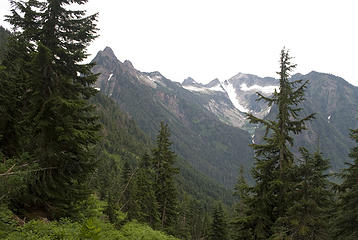 Big Four, Sperry, Vesper, Little Chief 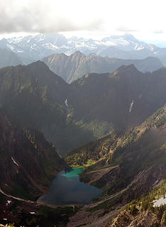 Copper Lake and Williamson Creek 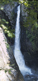 Falls from Copper Lake
|
| Back to top |
  
|
|
wolfs
Member

Joined: 07 Oct 2004
Posts: 302 | TRs | Pics
|
|
wolfs
Member
|
Thu Aug 28, 2008 4:10 pm |
|
|
Good lord. That is Lame with a capital L.
Now mind you I understand some of the underlying issues. For sure roads are expensive. And overall it's a pretty trashed up area back there, full of not very nwhikers type outdoor activity such as Fridge Dumping and Portamethlabbing. I don't happen to go there very much because that kind of thing turns my stomach. But: I've hiked Greider Lakes a couple times and they are nice, and it's a good hike for kids just the way it is. And I've climbed Static a couple times too, it's a nice place because it is a little farther in there and not quite the zoo that exit 38 is too many weekends.
As far as the road issue: note that they plan to log more. So, not only do they actually need MORE roads to do so, they also have a cash source that could pay for maintenance of existing roads (need to finance state schools notwithstanding). There seem to be a lot of dishonest justifications.
A quote from the climbers statement listed, the quote being from a DNR land manager, re: much longer access to Boulder and Greider Lakes:
| Quote: | | Also apart from cost considerations, he described it as a benefit that some nearby lakes that are presently day-hiking destinations will become out of reach for ordinary hikers: the two Grieder Lakes and Boulder Lake. This is going to provide an enhanced recreational experience for those willing to spend a week on a backpacking trip, he said. |
Uhhhhhhh..... this is exactly the kind of Tool-ness and premade decision passing that gives our government a bad (worse?) name. We lose enough trailheads to nature already without this kind of crap going on.
|
| Back to top |
|
|
Schroder
Member
Joined: 26 Oct 2007
Posts: 6717 | TRs | Pics
Location: on the beach |
|
Schroder
Member
|
Thu Aug 28, 2008 4:14 pm |
|
|
The week-long backpacking trip comment also doesn't make sense since overnight camping is prohibited near Spada Lake.
|
| Back to top |
|
|
Scrooge
Famous Grouse

Joined: 16 Dec 2001
Posts: 6966 | TRs | Pics
Location: wishful thinking |
|
Scrooge
Famous Grouse
|
Thu Aug 28, 2008 4:26 pm |
|
|
| Schroder wrote: | | The week-long backpacking trip comment also doesn't make sense since overnight camping is prohibited near Spada Lake. |
hee hee hee ........ Good one, Schroder. I missed that particular point when I was referencing the "enhanced Backpacking experience" comment, on another thread.
Just a small example of the kind of meaningless verbiage used by government agencies, whether they're conducting public involvement meetings ........ or writing budget requests.
Having done the latter for a living at one point in my career, I do know whereof I speak. 
Something lost behind the ranges. Lost and waiting for you....... Go and find it. Go!
Something lost behind the ranges. Lost and waiting for you....... Go and find it. Go!
|
| Back to top |
|
|
Scrooge
Famous Grouse
Joined: 16 Dec 2001
Posts: 6966 | TRs | Pics
Location: wishful thinking |
|
Scrooge
Famous Grouse
|
Thu Aug 28, 2008 5:23 pm |
|
|
I almost think this should be posted in the History forum, as well, since it eloquently discusses the past, as well as the future.
| Schroder wrote: | Over the past 2 decades weve seen gradual restrictions on access to Sultan Basin. Now the Department of Natural Resources and Snohomish County P.U.D. want to phase out all public access to the basin and remove the remaining roads between 2011 and 2015.
Culmback Dam was constructed in 1965, creating Spada Lake as a primary reservoir for the City of Everett water system that operates out of Lake Chaplain, about 400 feet lower in elevation. At that time, recreational improvements were made as a condition of the permit to construct the dam. Two boat launches were built, a campground below the basin was developed and a scenic overlook above the lake was developed. Overnight camping within one mile of the lake was prohibited as well as use of motorized watercraft. In the 1970s, a trail system was developed over Bald Mountain, connecting Ashland Lakes on the Mountain Loop Hiway to Sultan Basin. Historically, this area had many mining trails that connected to other areas: Marble Pass and Headlee Pass to the Mountain Loop and Sheep Gap to Mineral City on the Skykomish River drainage. The Williamson Creek road on the North side led to the 45 mine operation at the base of Big Four and Hall Peaks and the outlet of Copper Lake. The Bren Mac mine on the upper Sultan River operated until the 1970s.
In 1984, the Snohomish County P.U.D. built the Jackson Hydroelectric Project, raising Culmback Dam by 62 feet and flooding the road at the South Fork and Williamson Creek. The South Fork section of road was relocated and the access to Williamson Creek was provided by a new road that traversed Bald Mountain. Several new boat ramps were built for the public and a large picnic area above the North shore was also built.
Then things started to go downhill for public access.
In the late 1980s, the road up the Pilchuck River to Culmback dam was gated. This was a heavily used 15 mile long road for access to the west end of Spada Lake and the south side areas of Mt Pilchuck. Most of the problems that resulted in its closure were with illegal camping and dumping. This road closure shut down access to the western end of the Ashland Lakes trail and about 36 square miles of land to public access.
The new Williamson Creek Road could be driven until the late 1990s when a washout off the steep slopes of Bald Mountain closed the road. The DNR then decommissioned the road and tore out all the culverts. This shut out another 16 square miles to public access, including Copper Lake and the Hall peak-Big Four area. In 2001, the PUD closed access to the dam and the North Shore picnic area. Work is underway right now to close the Elk Creek (East side valley) by decommissioning the road down to the Boulder Lake trailhead.
The remaining access the South Shore road is the next to go. When this is gone, it will shut out another 25 square miles and access for climbers to Prospect Peak, Static Peak, Red Mountain and Little Chief (already impossible). Greider and Boulder Lakes will be out of reach for most as another 7 to 8 miles is added to the trail. The total: 80 square miles of public land shut off to the public.
This article by Washington Climbers coalition gives more background on some of the issues.
The P.U.D. relicensing document can be found here.
Big Four, Sperry, Vesper, Little Chief Copper Lake and Williamson Creek Falls from Copper Lake |
I don't know whether it's too late for us to take back our land or not. Probably it is, because probably the only money left in future government budgets will go to pay the saleries of the people who enforce the prohibitions.  So we go where we can, while we still can ....... and wonder where Jason's brother Jeremy will go when he gets to be our age. So we go where we can, while we still can ....... and wonder where Jason's brother Jeremy will go when he gets to be our age. 
Something lost behind the ranges. Lost and waiting for you....... Go and find it. Go!
Something lost behind the ranges. Lost and waiting for you....... Go and find it. Go!
|
| Back to top |
|
|
Sultan Guy
Member

Joined: 22 Jul 2008
Posts: 353 | TRs | Pics
Location: Now reinforced with Concrete |
| Schroder wrote: | | The week-long backpacking trip comment also doesn't make sense since overnight camping is prohibited near Spada Lake. |
At the May meeting that I attended I pointed this out to the PUD staff since they are very sensitive to any camping near the lake. They had not thought of that issue for some reason
Someone threw out a commmet about having designated camping sites where outhouses could be located.
I also asked exactly what the road would look like when converted to a "trail"? The DNR guy chimed in and said that they might replant some of the roadbed to enhance the recreational hiking asthetics...  WTF! WTF!
Any worthwhile expedition can be planned on the back of an envelope- H. W. Tilman
Any worthwhile expedition can be planned on the back of an envelope- H. W. Tilman
|
| Back to top |
|
|
Sultan Guy
Member
Joined: 22 Jul 2008
Posts: 353 | TRs | Pics
Location: Now reinforced with Concrete |
Schroder,
Thanks for starting this thread. I have known about the South Shore Road issues for about two years but just recently found this forum so I apologize for appearing to be a bit tardy...  I will post further updates as I hear about them to this thread, just be prepared for a never ending lengthy drawn out process.
Any worthwhile expedition can be planned on the back of an envelope- H. W. Tilman
Any worthwhile expedition can be planned on the back of an envelope- H. W. Tilman
|
| Back to top |
|
|
Sabahsboy
Member

Joined: 18 Jul 2006
Posts: 2484 | TRs | Pics
Location: SW Sno County |
Page, "Hiking in Sultan Basin" still lists both trails, Boulder Lake and Greider Lakes; however, a side bar notes that the road from Grieder Lake TH to Boulder Lake TH is gated and closed. Also, Sultan Basin Road will be clsoed on Sept. 8 until October 18 (from Hy 2); hiking is allowed until DNR/whoever removes porta-potties at Greider Lakes TH or about October 15. There is no note that road access from Olney Pass will close sooner...but, there is cavalier account of conditions and the over-all report of 2006 seems smug and resolute. Just when and where were all the public comments made, etc.?
I think this comprises a shady deal and was created to exclude the public. What reasons? Well, for the fishies. Well, to keep out noxious weeds. Well, to bar garbage dumping. Well, to keep out loners and friends with shotguns....etc.
It may be cheaper to hire rangers than to spend millions closing up territory. And, keeping secret the "real reasons for closure". Heck, there might be spies hiding behind bushes just yards from Grieder Lake TH...! Worse, traiters, scum, baby peddlers, weed farmers, who knows?
Closure of This vast area means ever more pressure on other areas by a public who has had declining interest in outdoors activities in lieu of "virtual play" and fat-ass sitting. Get the kids out and maybe they might lose a few lbs. of lard! What ever happened to Boy Scouts? Cub Scouts? Girl Scouts?
Our culture took a 90 degree turn somewhere between KFC, Golden Arches and tech games. Even I find myself ever so much more viewing "reality" from a chair in front of a screen than on my feet, in my boots, on natural, un-virtual dirt, roots and rocks! The Devil IS in the details and it frightens me. We can read of the thinning and melting of the Arctic ice, Global Warming, Greenland's slipping glaciers and Antarctic's collapsing ice shelves and glaciers plus the melt of glaciers, both marin terminous and alpine, around the globe...and we can get real disturbed...but, WHO DOES ANYTHING ABOUT IT? I never heard of Obama addressing the issue(s) nor of McCain standing up to his cronies that want him to continue the Bush Years.
Are we doomed to balloon into fat ass kids and oldsters, die of diseases related to fatty arteries, clogged veins, busted heart valves, etc. while China opens two coal belching power plants a week and particulate falls on once pure snow to melt the last snowdrift that might have been the seed of the last glacier? Are Americans so cowardly as to give up our independent mindset of wilderness and lay back, dance fingers on keyboards while downing McDonalds shakes and fries, and just believe that "some one will take care of everything..."?
The "someone" is us! We ARE they and it! No one else will do it!
If Obama will be President, then we must pressure him and Congress to ACT NOW...to open treasured walks and trails, let our sons and daughters discover wildness beyond concrete swimming pools and paved basket ball courts.
We humans have a gene somewhere that needs to explore....address that and follow the course....explore more than the tucked away acre park down the street and seek taller peaks, wider rivers and creeks, examine flora a fauna, not as a middle school projects but as a family events.
The terrible automobile allowed some of us to reach the edges of wilderness even before Wilderness became political and institutional. From those margines of wildness emerged at least one generation that loved the excitement of Grand Canyon, the soaring Grand Tetons, the wide meadows dotted with elk, moose and bear (and, now, ever so fortunately, wolves) at Yellowstone. Kids learned the names, geography and content of many, even all National Parks, monuments and other historic or wild places. What happened to that ethic and moral wonder?
Now, we must sit back and let God - like Agencies of Our Great White Father Government, whether Snohomish P. U. D. or BLM, decide where we will ever tread again. Hell, THIS IS OUR LAND!
Those "decommissioned roads" should be trails, improved to quality standards and set aside as primeval access for those of us who care. Heck, maybe the new trails will become all the rage!
If several railroad grades can be that, so could abandoned roads that travel into areas long unlogged and left to wither (or, flourish).
Access to Sultan Basin must be enhenced, not decommissioned! This is not China...and, the China that we perceive is changing so rapidly that they may end up being the true environmentalists as the 1.3 billion Chinese discover wilderness all around them and want to be in it, not as an urban experience, but as a lonesome, soul-purifying experience.
'nough written.
|
| Back to top |
|
|
xan
Member
Joined: 31 Mar 2007
Posts: 222 | TRs | Pics
|
|
xan
Member
|
Thu Aug 28, 2008 6:39 pm |
|
|
| wolfs wrote: | | Good lord. That is Lame with a capital L.
As far as the road issue: note that they plan to log more. So, not only do they actually need MORE roads to do so, they also have a cash source that could pay for maintenance of existing roads (need to finance state schools notwithstanding). There seem to be a lot of dishonest justifications. |
Uh..except that most of the upper Sultan Basin, and the area immediately tributary to the to-be-decommissioned S shore road, is, like Si or the N slope of Tiger mtn, NRCA (Natural Resource Conservation Area), and hence will not be logged.
It is worth noting, too, that this is a drinking water reservoir. How much public access of any sort is permitted in the Cedar watershed, or the S Fk Tolt? Zip, zilch, zero. The Sultan basin is by those standards a total anything-goes free fire zone.
|
| Back to top |
|
|
Backpacker Joe
Blind Hiker

Joined: 16 Dec 2001
Posts: 23956 | TRs | Pics
Location: Cle Elum |
| xan wrote: | | wolfs wrote: | | Good lord. That is Lame with a capital L.
As far as the road issue: note that they plan to log more. So, not only do they actually need MORE roads to do so, they also have a cash source that could pay for maintenance of existing roads (need to finance state schools notwithstanding). There seem to be a lot of dishonest justifications. |
The Sultan basin is by those standards a total anything-goes free fire zone. |
That is inaccurate. Yes, at one time the basin was pretty free to much of anything/everything. Not anymore. Years ago they curtailed the 4x4's, the shooting and the ATV's. It isn't necessary to close that road assessing Greider and Boulder. Certainly not to Olney Pass. If you're going to do that kill the bastard where it turns to gravel!
"If destruction be our lot we must ourselves be its author and finisher. As a nation of freemen we must live through all time or die by suicide."
Abraham Lincoln
"If destruction be our lot we must ourselves be its author and finisher. As a nation of freemen we must live through all time or die by suicide."
Abraham Lincoln
|
| Back to top |
|
|
Gil
Member

Joined: 29 Sep 2004
Posts: 4062 | TRs | Pics
|
|
Gil
Member
|
Thu Aug 28, 2008 11:00 pm |
|
|
The very first hike we went on with our kids when we moved back here in 2000 was Greider Lakes. My son (then 7) and I went swimming in Big Greider. Granted, I haven't been back in there for three years, but those are great hikes. It'd be sad if that road were closed.
Friends help the miles go easier.
Klahini
Friends help the miles go easier.
Klahini
|
| Back to top |
|
|
peltoms
Member

Joined: 13 Jul 2006
Posts: 1760 | TRs | Pics
Location: Worcester MA |
|
peltoms
Member
|
Fri Aug 29, 2008 4:34 am |
|
|
It is interesting to see a desire to ban all access to reservoir lands. In many regions of the nation, the plan is just the opposite, keep all development away, but allow minimal impact day use recreation. This helps keep the land patrolled and patrollable and opens up lots of open space for recreation.
|
| Back to top |
|
|
Stefan
Member

Joined: 17 Dec 2001
Posts: 5091 | TRs | Pics
|
|
Stefan
Member
|
Fri Aug 29, 2008 10:59 am |
|
|
Folks, it's all about money.
You want it open? Then you gotta allow logging.
|
| Back to top |
|
|
Hulksmash
Cleaning up.

Joined: 20 Apr 2008
Posts: 7113 | TRs | Pics
Location: Arlington |
|
Hulksmash
Cleaning up.
|
Fri Aug 29, 2008 11:13 am |
|
|
Much of this is simply reposting what i have posted in other threds, but maybe it will be easier to find here.
The past week or so i've been trying to read as many documents available on line regarding this subject, sultan guy obviously has a two year head start. No doubt he has much more information that me. Here's my gripe.  This quote is from the PUD's Pre-Application Document
vol1
http://www.snopud.com/water/relicensing/relicensingdocs/pad.ashx?p=3121#
This quote is from the PUD's Pre-Application Document
vol1
http://www.snopud.com/water/relicensing/relicensingdocs/pad.ashx?p=3121#
| Quote: | | Issue: What is the status of all roads used to access the Project in terms of ownership,
ongoing maintenance costs, easements, need and level of use? (DNR 05/23/05)
The co-licensees share maintenance costs with DNR for the South Shore Road, which
provides the only access to the south shore recreation sites, DNR Greider Lake and
Boulder Lake trailheads and NRCA lands, and USFS lands. The DNR expressed concern
that the co-licensees may not have complete authorization for all roads currently in use
for access. A full review of the permits, easements and other rights of access to the
Project, and the continuing need for same will be undertaken. The co-licensees and the
USFS have requested that DNR make no final decisions regarding road closure through
the current FERC license term (May 31, 2011), and until more information regarding
public use, interest and need for the roads in question can be gathered and evaluated
during the relicensing process. DNR has complied with this request. |
Did you read that carefully, on the urging of other govenment agency's the DNR has kept the road open, if was not for this the road would already be history!!!
| Quote: | | Issue: What is the status of the DNR-proposed abandonment of the South Shore Road?
(DNR 05/23/05 and USFS, IAC, whitewater boaters, and climbers 06/07/05)
Due to concerns about potential resource damage and ongoing maintenance costs
associated with the South Shore Road (SL-ML Road), the DNR has proposed to
decommission the road. Additional reasons given by the DNR for the proposal include
the lack of timber revenue from areas served by this road, the need for costly upgrades to
the road to meet current state Forest Practice Standards, and transfer of its lands to the
east and south of Spada Lake into the Natural Resource Conservation Area (NRCA)
management designation. Presently the co-licensees share the cost of maintaining this
road because it provides the only access to the Projects south shore recreation sites. This
road also provides access to USFS lands in the upper watershed and to DNRs lands in
the vicinity of the Project, including the popular Greider Lake and Boulder Lake
trailheads located beyond the Jackson Project recreation sites. Prospectors use the road to
access their active mining claims on USFS lands. Preliminary information gathered from
the current Recreation Visitor Survey indicates that a significant number of visitors to the
Sultan River basin are accessing lands managed by the DNR and USFS rather than
Project lands and facilities. As a result, the co-licensees believe that continued road
maintenance cost-sharing is appropriate. Annual maintenance costs incurred by the colicensees
for the South Shore Road equal approximately $62,000.
Closure of this road would jeopardize motorized recreation access (possibly changing it
to non-motorized access), as well as the practical viability of the existing Project
recreation and boating access sites located on the south shore of Spada Lake. The Bear
Creek Recreation Site, the most distant from the Olney Pass point of entry to the south
shore of Spada Lake, is approximately six miles by road. DNR trailheads for Greider
Lakes and Boulder Lake respectively, require an additional one to two miles of travel.
The co-licensees are engaged in ongoing discussion with the DNR as road closure would
substantially impact public access and the nature of public recreation in the basin. DNR
has deferred a final closure decision until 2011 when it will have the benefit of
information gathered during relicensing and from consultation with neighboring
landowners.
Road closures could result in greater co-licensee responsibility and cost for road
maintenance and possibly abandonment, relocation or revision of certain recreation sites.
However, until all recreation studies, public comment, and evaluation of the issues and
alternatives have been evaluated, it is difficult to predict the extent to which existing
conditions may change, if at all. |
Lack of timber revenue? The area has been logged in the past, as a state land trust, with money going to schools. If it has been logged in the past, it stands to reason it can be logged in the future. Water quality issue with logging? It didn't cause a water quality issue in the past. The tolt and ceader water sheds are logged. Not causing water quality issues! Oh, and no more money for schools!
Did you catch this "Road closures could result in greater co-licensee responsibility and cost for road
maintenance" Not the DNR's problem it dosn't come out of there budget  Right?
Ok so how much is a "costly upgrade" Right?
Ok so how much is a "costly upgrade"
| Quote: | | Costs associated with South Shore Road from South Fork Bridge to the Greider Lake trailhead (5
¼ miles):
1. Bring up to standards - $242,000. Includes replacing all culverts and 3 fish passage
projects, plus other repairs. About half of costs involve fish passage.
2. Annual maintenance - ~$32,000. Includes grading, brush cutting, annual storm events
and averages in major slides.
3. Abandonment - ~$25,000. Includes pulling culverts, excavating unstable fill slopes,
installing intermediate water bars, revegetating, and blocking entrance to the road. |
242,000 bucks to upgrade the road today. In 1991 it cost $2,211,390.70 to install the recreation sites. Anyone want to crunch the numbers and figure out the adjused value after 17 years of inflation? These site's will be abandoned if the road is closed! In addition to lost access to Grider, and Boulder lakes.
Half of $242,000 going to fish passage. From the lake to where? Given the rugged topography of the area those fish are not going far up stream. Did they bother reading the fishery report?
http://www.snopud.com/water/relicensing/relicensingdocs/studyrpts.ashx?p=3608#
SP5: Juvenile Fish Abundance, Life History and Distribution Progress Report
| Quote: | | Spada Lake, the reservoir created by Culmback Dam, has a surface area of 1,870 acres
when full, making it the largest lake in Snohomish County (Figure 2-1). Its maximum
depth near the dam is over 200 feet. Under normal operations its volume varies from
87,748 acre-feet (at 1,410 feet mean sea level [ft msl]) to 153,260 acre-feet (at 1,450 ft
msl) (Figure 2-2). The lake has a flushing rate of approximately three times a year. This
flushing removes nutrients, which, coupled with low nutrient inputs, makes the lakes
fish production potential quite low (Pfeifer et al. 1998).
Spada Lake begins to thermally stratify in April, reaches maximum stratification in late
summer, and then de-stratifies typically by early November (Figure 2-3). Bottom
temperatures range from approximately 4°Centegrade (°C) in winter to 10°C in October.
Mean surface temperatures reach approximately 18°C in July and August while
maximum surface temperatures often exceed 20°C during this period. The temperature
differential between mean surface and mean bottom temperature is about 10°C in the |
Wow! Got'a take care of those fish passages on a lake with little nurrients, that dosen't produce many fish
Oh by the way rgarding the fish. The state has been on a crusade to remove creosote treated lumber from the puget sound, the govoner gave the DNR 4million dollars to help fund the effort.
The DNR seems to be quiet proud of there efforts.
http://www.dnr.wa.gov/Publications/aqr_cleanup_creosote_summaries.pdf
http://www.wsdot.wa.gov/ferries/your_wsf/corporate_communications/creosote/
What does this have to do with Spada Lake? Well here it is
 old bridge debries in next to sultan river 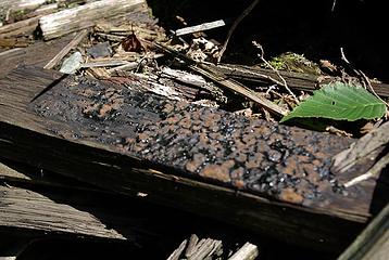 creosote oozing from old bridge debries near sultan river | Quote: | | A coal derivative and carcinogen in laboratory animals, creosote can cause skin and eye irritation, sweating, nausea and subsequent convulsions or coma from repeated or prolonged contact, and if ingested in high concentrations, death.
Creosote has been reported to cause cancer in laboratory animals and has also been associated with skin cancer in some workers occupationally exposed to creosote. No consistent data on low level exposure effects to humans are available.
Creosote contains phenolic compounds. Phenols in water are known to cause bad taste in fish for human consumption at concentrations of 1-10 mg/L. Effects on drinking waters which is chlorinated are also evident even at a concentration around 0.001 mg phenol per litre. Some chemicals in creosote, such as the tar acids and the napthalenes, are biodegradable and will soon be decomposed and assimilated by microflora. Other fractions of creosote, including fluorine, chrysene and pyrene, are biodegraded very slowly. The harmful effects of these compounds on a natural microflora in soil close to treated poles are therefore likely to last for a longer period of time |
Why is there no data? It's because no one has studied it yet!
Here's the unfunny irony
http://www.dnr.wa.gov/RecreationEducation/News/Pages/nr07_002.aspx
| Quote: | | I am pleased to make this significant addition to the existing conservation and recreation landscape in the Upper Sultan Basin, said Commissioner of Public Lands Doug Sutherland. This transfer connects three existing NRCAs, helping to protect Everetts municipal watershed and assuring continued public access to scenic trails and camping opportunities. |
 What a bunch of clowns
Here's my sugestion.
1. Since i may cost the taxpayer more to abandon the road DON'T!
2. The cost of improving the road could be cut in half by not takeing care of the fish passage issue on this road. Mitigate by spending the money elsewhere on a fish passage issue on more a more productive body of water.
3. Get rid of the potential toxic time bomb, one good flood event from being washed into spada lake.
In this way the DNR might be able to save face. If they give a sh@# What a bunch of clowns
Here's my sugestion.
1. Since i may cost the taxpayer more to abandon the road DON'T!
2. The cost of improving the road could be cut in half by not takeing care of the fish passage issue on this road. Mitigate by spending the money elsewhere on a fish passage issue on more a more productive body of water.
3. Get rid of the potential toxic time bomb, one good flood event from being washed into spada lake.
In this way the DNR might be able to save face. If they give a sh@#
"Bears couldn't care less about us....we smell bad and don't taste too good. Bugs on the other hand see us as vending machines." - WetDog
Albuterol! it's the 11th essential
"Bears couldn't care less about us....we smell bad and don't taste too good. Bugs on the other hand see us as vending machines." - WetDog
Albuterol! it's the 11th essential
|
| Back to top |
|
|
Backpacker Joe
Blind Hiker
Joined: 16 Dec 2001
Posts: 23956 | TRs | Pics
Location: Cle Elum |
Ole Hulker and SG sure are good for information.
Thanks guys.
"If destruction be our lot we must ourselves be its author and finisher. As a nation of freemen we must live through all time or die by suicide."
Abraham Lincoln
"If destruction be our lot we must ourselves be its author and finisher. As a nation of freemen we must live through all time or die by suicide."
Abraham Lincoln
|
| Back to top |
|
|
|
|
You cannot post new topics in this forum
You cannot reply to topics in this forum
You cannot edit your posts in this forum
You cannot delete your posts in this forum
You cannot vote in polls in this forum
|
Disclosure: As an Amazon Associate NWHikers.net earns from qualifying purchases when you use our link(s). |


