| Previous :: Next Topic |
| Author |
Message |
Sabahsboy
Member


Joined: 18 Jul 2006
Posts: 2484 | TRs | Pics
Location: SW Sno County |
|
Sabahsboy
Member
|
 Fri Aug 29, 2008 2:48 pm Sultan Basin's future access for public use?
|
|
|
With all the information flying around, is there any means that some of it can be put together and formalized; then comments and/or inquiries made of officials? And to whom would it be most effective to address comments and inquiries with greatest impact, bypassing those officials that would wish to suppress any challenges to the planning, esp. in light that the plans are dated in 2006?
My thought is our governor, but not until after election dust has settled. And, Committee Chairs (relevant to our cause or cause of environment and public access....) at State Legislature. There must be more...and, certainly, officials, elected, appointed or career who oversee agencies involved. In fact, this would let them know that they must defend and/or justify planning, such as closure of Sultan Basin Road, now at Grieder Lakes TH, later at Olney Pass, etc.).
Maybe we can get our collective heads together and come up with effective strategy? Bet we can!
There are several areas of interest (geographic areas) that might be merged, since all are linked:
Sultan Basin and watershed - Spada Lake drainage region;
drainages with formerly active logging or mining roads that could provide excellent trails, many or all of the low elevation kind so rare in the Cascades.
Consider maintaining trails to Boulder and Grieder Lakes and enhencing those routes (there is a beautiful bridge near the TH to Boulder Lake plus rest rooms, etc.. ).
Maybe even runnig a trail up to fabled Copper Lake!
The trail from Ashland Lakes across ridge to reach Cutthroat Lakes and loop back to re-instated Walt Bailey Trail (yes, spend some to maintain road access to Walt's TH).
Olney Creek - Mount Stickney and Lake Stickney, formerly a popular, drive-in area;
Mount Stickney access and public forest lands;
Wallace Falls State Park;
Wild Sky Wilderness (Lake Isabel - Ragged Ridge unit);
Possible other areas? Index Townsite (that might be a stretch; but the Index-Garland Springs road could be included since it has been a perennial maintenance problem and now must be replaced to provide access to extant, vacation home sites, road access to Blanca Lake TH and access to trails that weave from valleys to Cascade Crest. Thence, the Beckler River Road and access / loop road it provides the region.
Some of this is well within or edges to protected areas; some is within recent clear cuts. Trails are being reclaimed at Johnson Ridge (I understand) to provide more trail miles and differing access, a good way to disperse hikers and horsemen rather than gang all onto a single route.
The population of Puget Sound region is not ever going to retreat; it is doubtful that the percentage of population will ever fall so low as to make trail maintenance a silly and useless issue; ditto access roads to trailheads.
If allowed, there will always be pressure to take mineral and renewable (forest) wealth from the fringes of Pugetopolis. Biggest risk is the ever greater need for gravel and rock; but prescious and other metals could cause rapid development and decline in Puget City's hinterland.
WATER: This could be the key in preservation...and is being used (?) by those Snohomish planners to close off many, many square miles. However, the entire Cascade Range is a water source, a reservoir, much of it purified by waters percolating through tree roots and other perennial and annual plants. This system holds soils, soils that are not ancient since those were scraped away by Ice Age Claciers. By peeling away the forst cover, we allow rainfall to etch the surfaces and become erosion zones, washouts and other catastrophic (geologic) events.
It would take an awful lot of people peeing to do equivalent damage, eh?!
Perhaps 1.3 billion folks at the very exact moment, unleashing a torent down a selected stream. but, then, there would be no standing room, would there?!
What is needed is expansion of trails and routes for an ever expanding population of hikers, both day hikers and backpackers as well as scramblers, climbers and technical climbers, etc. Then, of course, how to keep separate the ATVers/ORVers, mountain bikers, horsemen, and other users plus the seasonal hunters (minus those under 16 years old...another issue, of course). And, kayakers, float trip operators and solo floaters on streams and lakes, etc.
And, can flights be regulated for landings on Lake Isabel and other high lakes?
Then, the High Lakers and their kind that plant fry and fish and love-to-death fishing holes of fishermen. Many of these folks glory in the sport and rarely take the fish, but return the critters ot waters for yet another season of growth.
Of migratory fish in the Spada Lake Basin....are there any? I don' tknow, but I think there is no means for ocean going, migratory salmon to reach upper Olney, but esp. upper Sultan and other rivers. I could be wrong, though. Nevertheless, native, fresh water fish deserve a fine environment low on silt run-off and high in valued nutrients, shade and such...mosquitos inclusive.
Without access, who will venture into back country to weed out Crupina vulgaris and other noxious weeds? How will bears and frogs be counted as Global Warming takes on even greater effect?
The present Administration wishes to allow vast expansion of development on public lands via new and Federal (taxpayer) paid roads; yet, over the ridge we have the obverse. It is a crazy quilt of regulation, non-regulation, inferior planninig and far worse politics.
I am just throwing out thoughts...forgive me!
SB
Potential Study Area:
Mount Pilchuck at NW corner to Monte Cristo road and Glacier Basin at the NE corner;
Skykomish Ranger Station at the SE corner to Blue Mountain at the SW corner.
However, this is an irregular polygon and really must be examined as to what should be studied and expanded. Some of the peripheral or "buffer" around Wild Sky Wilderness needs to be examined. There are many potential hikes or present routes that are difficult and should be made easer for families to hike, such as some historic mne sites, maybe and most especial, Mineral City.
Hey! We need a good trail with signage to access Lake Isabel! How about a trail that is more formal that runs from Upper Falls of Wallace River to the upper reaches of Wallace River, perhaps creating a loop over ridge to descend to Lake Isabel. And, re-establish the RR / Road bed as TRAIL, eastwardly from Upper Falls of Wallace River on the extant grade (go west and reach Wallace Lake) to Lake Isabel. Of course, some cash$ is needed to build a foot bridge across Wallace River just above brink of Upper Falls, a spectacular spot if ever there was one!
|
| Back to top |
  
|
|
Scrooge
Famous Grouse

Joined: 16 Dec 2001
Posts: 6966 | TRs | Pics
Location: wishful thinking |
|
Scrooge
Famous Grouse
|
Fri Aug 29, 2008 5:29 pm |
|
|
A minor point: SG, you rememember that "half of $242,000 would be required fish-friendly culverts, etc?
Sabahsboy just speculated | Quote: | | Of migratory fish in the Spada Lake Basin....are there any? I don' tknow, but I think there is no means for ocean going, migratory salmon to reach upper Olney, but esp. upper Sultan and other rivers. |
He's right, of course. Any fish up there are put there by Fish and Wildlife. The trout in the streams don't need any special culverts. That DNR "either-or" figure is totally spurious. 
Something lost behind the ranges. Lost and waiting for you....... Go and find it. Go!
Something lost behind the ranges. Lost and waiting for you....... Go and find it. Go!
|
| Back to top |
|
|
Hulksmash
Cleaning up.

Joined: 20 Apr 2008
Posts: 7113 | TRs | Pics
Location: Arlington |
|
Hulksmash
Cleaning up.
|
Sat Aug 30, 2008 1:05 am |
|
|
Sabahsboy wrote
| Quote: | | With all the information flying around, is there any means that some of it can be put together and formalized; then comments and/or inquiries made of officials? |
This is something i've been thinking about, but i don't have the first clue where to start, or how to go about it, except for post my gripe's here. In the hope that someone who has th know how does know where to start.
| Quote: | | can flights be regulated for landings on Lake Isabel and other high lakes? |
Float planes landing in wilderness area lakes is a no no. I do believe it's prohibited with in national forest's as well. However lake Isabel is unique in that the wildsky bill has a provision to allow it. If it becomes a problem there should be some regulation. But with 100LL being six to seven dollars a gallon, and jet A being in the same ballpark. The cost's associated with maintaining a general avaition air craft. I forsee few air panes landing in the lake. I seriously doubt any comercial venture could be profitable, since what drives profits in the aviaton world is capacity. A piper cub has little capacity. The only thing that might have capicity that can land in the lake, Cessna Caravan. Well used amphibious versions run 2 million plus, again economics don't support it. So let a few rich folks enjoy there flyin "wilderness experience"  But this is thread drift. But this is thread drift.
| Quote: | | Of migratory fish in the Spada Lake Basin....are there any? I don' tknow, but I think there is no means for ocean going, migratory salmon to reach upper Olney, but esp. upper Sultan and other rivers. I could be wrong, though. Nevertheless, native, fresh water fish deserve a fine environment low on silt run-off and high in valued nutrients, shade and such...mosquitos inclusive. |
On migratory fish. The sultan river has been an odd ball, since 1984 pinks spawing numbers have increased 1100%. Yea you read that right. 1100%
Chinook have increased 27%.
The canyon below the dam, is considered a fish barrier it's self. So migatory fish are not likely to make it to the base of the dam. Why the increase in number's? There's a theroy, that say that the dam has regulated the "flashy" nature of the river, and is makeing it easier for migratory fish to survive. At the same time, this could weaken the fish in the long run, because i allows the weaker fish to breed.
On resident trout, the same "flahy" nature of the rivers flushes out valued nutrients out of the lake. So maintaing one road will have little effect on the trout. But I'm no expert. I just read the fishery reports.
"Bears couldn't care less about us....we smell bad and don't taste too good. Bugs on the other hand see us as vending machines." - WetDog
Albuterol! it's the 11th essential
"Bears couldn't care less about us....we smell bad and don't taste too good. Bugs on the other hand see us as vending machines." - WetDog
Albuterol! it's the 11th essential
|
| Back to top |
|
|
Scrooge
Famous Grouse

Joined: 16 Dec 2001
Posts: 6966 | TRs | Pics
Location: wishful thinking |
|
Scrooge
Famous Grouse
|
Sat Aug 30, 2008 8:49 am |
|
|
Poor Spada fishies. I did a little reading in that "pre-licensing document", and happened to dig into
Factors Limiting Trout Production in Spada Lake
Final Technical Report for
Revised Study Plan 16: Spada Lake Trout Production
to try to gain some insight into how the needs of the fish in Sultan Basin could effect a decision to end public access to the area.
Here are a couple of samples from that Trout Production study (one tiny piece of the expenditures that could have gone to fill a pothole. ....... This is an excerpt from the Introduction:
| Quote: | | To determine the relative importance of food supply, prey quality, and thermal
regime on growth of trout in Spada Lake, Beauchamp (2006) used bioenergetics model
simulations combined with existing data on diet, growth, and temperature conditions that
were reconstructed or approximated for four different phases of reservoir operation:
1979-1980, 1986, 1992, and 1995-1997. The objectives of these simulations were to: 1)
estimate the average annual feeding rate of trout in terms of total prey biomass consumed
per individual trout and as a proportion of the theoretical maximum consumption rate for
trout of the same size that experience the same thermal regime; 2) compare feeding (as a
proportion of maximum consumption) and growth performance (age-specific growth rate
and growth efficiency) of trout during the four phases of reservoir operation reported.
Growth efficiency (GE) is a measure of growth in weight as a percentage of the weight of
food eaten to generate that growth over some specified period (a year in this case), and
thus provides a metric for how efficiently food was converted into somatic growth. High
growth efficiencies are typically associated with feeding at moderate to high rates on high
energy diets, or feeding at high rates on moderate to high energy diets. In both cases,
more surplus energy is available to convert into growth after metabolic and waste losses
have been satisfied. Similar analyses were required to evaluate the current growth
conditions for trout and to compare the current situation to previous production regimes
in Spada Lake.
Prior to this study, the specific factors that currently limit trout production in
Spada Lake remained undetermined. Consequently a field sampling effort was mounted
during April-November 2007 to measure key data on limnological conditions
(temperature, zooplankton), and fish populations (size structure, distribution, diet, and
abundance of trout and other fishes) to assess the current physical and biological
characteristics of the reservoir fish community (Meridian Environmental and Shuksan
Fisheries Consulting 2008). These data were targeted to provide inputs into a
bioenergetically-based food web model that would be used to determine what processes
limit trout production. |
If that bit of gobbledygook hasn't got you changing channels, check a random sample from the study, itself:
| Quote: | 3.2 Stable Isotope Analysis
The range in average δ15N signals (from 5.5 to7.6) across all sizes of
brown bullheads, trout, and largescale suckers Catastomus macrocheilus spanned less
than one full trophic level (δ15N 3.0-3.4; Figure 1). Brown bullheads showed
significantly higher trophic position (δ15N) than all species of trout (ANOVA and twosample
t-tests, P < 0.002). Brown bullheads overlapped considerably in carbon source
(δ13C) with cutthroat (P = 0.40) and rainbow trout (P = 0.07), but differed from large
Jackson Hydroelectric Project (FERC No. 2157)
Spada Lake Trout Production Page 12
Technical Report
hybrid trout (P = 0.02). In general, trout diverged somewhat from brown bullheads with
lower δ15N and higher (less negative) δ13C, suggesting a heavier reliance on benthic
invertebrates by trout, and a slightly higher tendency toward pelagic carnivory (higher
δ15N and lower δ13C) by brown bullheads. Both small and large largescale suckers
focused on lower trophic-level benthic invertebrates.
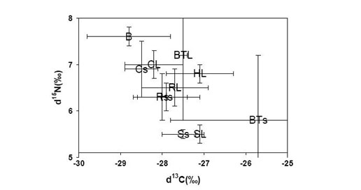 Stable isotope graph.. |
Did you pick up on "Thus, the patterns in δ15N showed no evidence for
a significant shift toward piscivory by larger trout and corroborated the findings from the
diet analysis." No. Probably not. Because the only point is that the rest of the study doesn't snow much evidence for anything else, either. ......... But you paid for it. And because you paid for it and hundreds like, the people you hire at DNR (et cetera) can't afford to maintain a road for you to use.
Something lost behind the ranges. Lost and waiting for you....... Go and find it. Go!
Something lost behind the ranges. Lost and waiting for you....... Go and find it. Go!
|
| Back to top |
|
|
Backpacker Joe
Blind Hiker

Joined: 16 Dec 2001
Posts: 23956 | TRs | Pics
Location: Cle Elum |
People used to land planes on Isabel all the time. Occasionally crashing there too. Im not sure what the "Wild Sky" says about that.
"If destruction be our lot we must ourselves be its author and finisher. As a nation of freemen we must live through all time or die by suicide."
Abraham Lincoln
"If destruction be our lot we must ourselves be its author and finisher. As a nation of freemen we must live through all time or die by suicide."
Abraham Lincoln
|
| Back to top |
|
|
Hulksmash
Cleaning up.
Joined: 20 Apr 2008
Posts: 7113 | TRs | Pics
Location: Arlington |
|
Hulksmash
Cleaning up.
|
Sat Aug 30, 2008 9:49 am |
|
|
I have to admit when i got to this stuff my eyes glazed over 
| Quote: | | δ15N signals (from 5.5 to7.6)trophic level (δ15N 3.0-3.4; Figure 1). lower δ15N and higher (less negative) δ13C, suggesting a heavier reliance on benthic Average (± 2SE) stable isotope values δ15N and δ13C for brown bullheads (B, 100- |
But the report seems to confirm what i've observed since the 90's fish have declined. I just assumed it was because of increased pressure from over fishing. Like everywhere else.
Backpacker Joe wrote:
| Quote: | | People used to land planes on Isabel all the time. Occasionally crashing there too. Im not sure what the "Wild Sky" says about that. |
Wild sky bill allows lading planes on Isabell. This is burried in my previous post on this thread. Yes sometimes they crash. I failed to mention this in my previous post. They some times crash because, there is no way to to a "touch and go" once you make your "final approach" it is absoutly a "Final approach" Either land successfully or crash. Those are the options. Which is yet another reason why there will never be commerical operations in and out of the lake. I doubt the FAA will ever allow it due to the lack of a go around option. Again this is more thread drift
"Bears couldn't care less about us....we smell bad and don't taste too good. Bugs on the other hand see us as vending machines." - WetDog
Albuterol! it's the 11th essential
"Bears couldn't care less about us....we smell bad and don't taste too good. Bugs on the other hand see us as vending machines." - WetDog
Albuterol! it's the 11th essential
|
| Back to top |
|
|
Backpacker Joe
Blind Hiker
Joined: 16 Dec 2001
Posts: 23956 | TRs | Pics
Location: Cle Elum |
Hey Hulker, I'm not sure if you are, but I'm a pilot and I can tell you that the last few crashes have happened on take off. I was there a few days after the recovery of a Lake Buccaneer that stalled in on take off. They pulled it out with a CH47. All four people died. It was a major bummer.
Because all the lakes capable of accepting float planes have been locked up in wilderness areas nobody has any mountain lake flying experience anymore. For example there is a Piper Super Cub sitting upside down at the bottom of Spade lake. There is a Piper Tri Pacer sitting upside down at the bottom of Otter lake. Etc etc etc. It wouldn't surprise me if Angeline had a plane in her mits either. Interesting.
"If destruction be our lot we must ourselves be its author and finisher. As a nation of freemen we must live through all time or die by suicide."
Abraham Lincoln
"If destruction be our lot we must ourselves be its author and finisher. As a nation of freemen we must live through all time or die by suicide."
Abraham Lincoln
|
| Back to top |
|
|
Sabahsboy
Member
Joined: 18 Jul 2006
Posts: 2484 | TRs | Pics
Location: SW Sno County |
Not weighing in on anythig...just hope the thread keeps going and a group can form and pose some strategy to present to some certain Governor(s), Senators, Congresspersons, Legistlators, et al. Yup!
Since my last input a day ago, there is some very fascinating and valuable info and observation. Thank you all and we'll keep up the good work!
Pray that Sultan Basin will have a Renaissance rather than a burial!
|
| Back to top |
|
|
Hulksmash
Cleaning up.
Joined: 20 Apr 2008
Posts: 7113 | TRs | Pics
Location: Arlington |
|
Hulksmash
Cleaning up.
|
Sun Aug 31, 2008 10:38 pm |
|
|
As i read through relicencing douments, i keep finding references to Wahington Climbers Coalition, American Whitewater, American Rivers, Snohomish County Sportsmen
Association, Prospectors Mining Association, Trout
Unlimited, Hydropower Reform Coalition (there's a hydropower reform coalition?! )
The one association I cannot find is the Wahington Trail Association. Where is the WTA? Why haven't they issued any concerns regarding loosing access to Boulder and Grider Lakes?
"Bears couldn't care less about us....we smell bad and don't taste too good. Bugs on the other hand see us as vending machines." - WetDog
Albuterol! it's the 11th essential
"Bears couldn't care less about us....we smell bad and don't taste too good. Bugs on the other hand see us as vending machines." - WetDog
Albuterol! it's the 11th essential
|
| Back to top |
|
|
Jason Hummel
Member

Joined: 31 Aug 2006
Posts: 1209 | TRs | Pics
Location: Tacoma Washington |
As a former whitewater boater, I am dismayed to see access for kayaking further limited (just as i am for hiking and climbing and skiing ie crystal mountain and mount rainier park). Sultan is a beautiful creek and with conflict with dams and dam projects, we are further at odds. There was a plan for miniature damn projects at one point, now maybe more in the works with the cost of fuel and such. Over the years, access is an increasingly touchy issue, especially as storms wreck havoc on improvements and repairs. These past few years have been hard. I remember once on the white river being accosted by cop-sorts (not cops) hired by the logging companies (i'm assuming). I guess there was a fire ban and we weren't allowed on the property. It was raining and we walked a short way up a logging road to get off the creek. They had several vehicles waiting for us. It was a very unpleasant experience with lots of verbal abuse to which we said little. There are a few good projects I see. The damn being taken down on the Elwha and White Salmon Rivers. These are good improvements. I'm not well informed with access of the past beyond that of my own experience. It has seemed to me that it is becoming increasingly hard to understand when, where, how, why and so forth. I can't imagine taking a family out. It would be costly. There needs to be access or people will forget the wilderness and the monies needed to maintain will dry up along with the protections. Most importantly, it needs to be affordable. To me 30 bucks here and 5 bucks there isn't bad, but it really adds up for a family.
Nevertheless it would be sad to see access further limited on the Sultan. If 250k to fix a road is the reasoning behind it, then that seems minor. If there are other reasons, then maybe I would understand it better?
What I think needs to happen is a cultural change. Young adults in high school or just after need to volunteer for public service. It would be great if this were a requirement to graduate high school or college. 6 months building trails or cleaning up garbage or working any sort of job. Just in some way giving back, beginning at an early age to install a good ethos.
|
| Back to top |
|
|
Dalekz
Member
Joined: 01 Mar 2002
Posts: 487 | TRs | Pics
|
|
Dalekz
Member
|
Wed Sep 03, 2008 12:51 pm |
|
|
I sort of remember a number of years ago reading that the DNR had decided to cut their recreation access budget to next to nothing and everyting was going in for timber. I think they started on the east side by closing gates for access etc. Probably what is happening in the sultun area.
Just remember that the DNR head is up for re-election this year. Maybe a change will also result in a change of their policys.
|
| Back to top |
|
|
Sultan Guy
Member

Joined: 22 Jul 2008
Posts: 353 | TRs | Pics
Location: Now reinforced with Concrete |
To help the folks here better understand exactly what has happened in the Sultan Basin here is the official transcripts from a public meeting held 9/19/2007. I was not at this meeting but was at a meeting held 5/28/2008. There are significant updates from the May meeting that are not yet posted online.
| Quote: | | Kurowski presented information on DNRs plans for the Upper Sultan Basin NRCA. Currently,
there are three separate NRCAs (Natural Resource Conservation Areas); DNRs plan is to
combine them into one larger NRCA called Morning Star NRCA. This will form one large
NRCA on the north, east and south side of Spada Lake on DNR-managed lands, making it the
largest NRCA in the state at 30,000 acres. (The state has approximately 100,000 acres of NRCA.) The intent of NRCAs is to conserve and protect lands that do not meet the strict
requirements of Natural Area Preserves. Trust Lands (benefiting and funding schools systems),
are transferred from the Trust to be managed as a NRCA. Priorities for protection for NRCAs,
listed in order of importance, are:
1) environment preservation
2) low impact recreation (will be sacrificed if it negatively impacts the environment)
3) environmental education
South Shore Road
DNR does not need the South Shore Road to manage the planned NRCA; they can manage the
area via trails and backcountry crews. Motorized uses are not permitted within a NRCA.
Therefore, DNR plans to abandon the road in phases:
Greider Lake Trailhead to Boulder Lake Trailhead to be abandoned within the next two
years. Boulder Lake Trailhead will be moved to the current Greider Lake Trailhead. The
permanent toilet has already been removed from the Boulder Lake trailhead.
South Fork to Greider Lake Trailhead expected to be abandoned no sooner than 2011,
based on agreement with the PUD, due to ongoing relicensing studies and consultation.
South Fork to Olney Pass expected to be abandoned no later than 2015 based on Road
Maintenance and Abandonment Plan requirements. The master trailhead would be
expected to be located at the existing Olney Pass site and will transform the current dayhike
experience from Olney Pass to Greider Lakes and Boulder Lake into a longer
weekend/week experience. Eventually the old road bed would be replaced by a trail
system back into Boulder. Day hikes are available on the north side of Spada Lake to
Cutthroat Lake, across Bald Mountain, and to Ashland and Beaver lakes.
With the closure of the South Shore Road, options that DNR is considering include:
1) convert the old road into a trail, and/or
2) convert trails off old logging roads on the south side of Spada Lake, and/or
3) connect Boulder Lake to Greider Lake via a trail, and/or
4) create a back-country trail to Greider Lakes.
Mountain biking is not normally considered a compatible use within a NRCA and there are no
mountain bike trails currently in the NRCA. Kurowski made it clear that no one should count on
having mountain bike trails in the NRCA but, he was intrigued by the concept of biking to a
trailhead location, and then hiking into the NRCA.
Eychaner disclosed that there is a Natural Resource Advisory Council and Statewide Heritage
Council that is different from DNR.
Pilchuck Mainline PK-ML (Road on north side of Sultan River and northwest side of Spada
Lake)
Previously, the PK-ML road was open to vehicles and multiple recreation types. Due to public
abuse issues, such as vandalism, thefts, death, etc., the road was closed to automobiles; however,
Off Highway Vehicle (OHV) use was still permitted. Public abuse still occurred over time, so
the road was then closed to all motorized vehicles. Non-motorized uses, such as horseback
riding, mountain biking, and hiking are allowed on the road today. There are no trails accessed
from the road. Road use as a trail on DNR-managed Trust land is managed by the multiple-use
act and by allowance of the Trust as long as users obey the rules. Kurowski does not see much changing related to allowable uses on this road. He noted that the road is technically not
designated as a mountain bike trail.
Abandonment Costs for South Shore Road
DNR reported estimated costs for the South Shore Road options using DNR crews as follows:
$45,000 to abandon the road from Olney Pass to Greider and Boulder trailheads
$250,000 to bring the road up to WA Forest Practice Standards (replace culverts, etc.)
$35,000/annually to maintain South Shore Road
Abandonment would be simple abandonment pull culverts, water bars, side casts, block off
to vehicles, etc. One can lessen the slope where very steep to accommodate hiking. Overall, it is
much less expensive for DNR to abandon the road than to bring it up to WA Forest Practice
standards and to continue to maintain this road. |
For the full text of this meeting you can find it here. It is SP13. http://www.snopud.com/water/relicensing/meetings/spudates.ashx?p=3507
At the 5/28/08 meeting we were presented with and discussed the merits of three options for the South Shore Road. I filed comments on these options wearing both my hiking and kayaking hats. The next meeting is scheduled for 9/25/08 at 9 AM in Everett. If anyone from NWhikers.net or WTA would like to attend you just need to let Dawn Pressler know by 9/19. DJPresler@snopud.com
I would like to point out and remind everyone that this is really a DNR decision regarding managing DNR lands. The Snohomish PUD is just an unfortunate agency that built $$ rec areas from the DNR's road. These rec areas have been very underutilized but served the criteria of meeting the FERC's requirements for recreational mitigation for Phase 2 of the Jackson Hydroelectric Project that raised the dam.
I understand everyone's frustration with the decision to possibly close off the Boulder and Grieder lakes TH's. I love those lakes and have taken my kids up there many times including the first camp out with my oldest son. They will always be special to me.  In my opinion the DNR has done a poor job of explaining their decision regarding the South Shore Road to the hiking public. I am trying to contact the appropriate people to ask what the process is for interested hikers to comment on the long term plans for the Morning Star NRCA and how it is managed. I would hope that as a WA State agency they would have a process to allow public comment.
Stay tuned....
In my opinion the DNR has done a poor job of explaining their decision regarding the South Shore Road to the hiking public. I am trying to contact the appropriate people to ask what the process is for interested hikers to comment on the long term plans for the Morning Star NRCA and how it is managed. I would hope that as a WA State agency they would have a process to allow public comment.
Stay tuned.... 
Any worthwhile expedition can be planned on the back of an envelope- H. W. Tilman
Any worthwhile expedition can be planned on the back of an envelope- H. W. Tilman
|
| Back to top |
|
|
Sultan Guy
Member
Joined: 22 Jul 2008
Posts: 353 | TRs | Pics
Location: Now reinforced with Concrete |
Any worthwhile expedition can be planned on the back of an envelope- H. W. Tilman
|
| Back to top |
|
|
Scrooge
Famous Grouse
Joined: 16 Dec 2001
Posts: 6966 | TRs | Pics
Location: wishful thinking |
|
Scrooge
Famous Grouse
|
Wed Sep 03, 2008 7:38 pm |
|
|
Interesting. Private lands bordering the upper third of Williamson Creek, and the whole slope up to Marble Pass. Also National Forest lands up to and around Copper Lake, as well as down the slope north of Marble Pass.
When DNR closes off Sultan Basin, they won't have any say in what goes on up there ......... and they won't even have any presence in the Basin to check up on what goes on up around the Williamson Creek headwaters.
I'd say that, in the future, there's a pretty good chance we'll be able to build a decent trail over the Pass. No bridge, but fording ........ or rafting  rivers has been standard practice in a lot of places for a lot of years. rivers has been standard practice in a lot of places for a lot of years.
Something lost behind the ranges. Lost and waiting for you....... Go and find it. Go!
Something lost behind the ranges. Lost and waiting for you....... Go and find it. Go!
|
| Back to top |
|
|
Hulksmash
Cleaning up.
Joined: 20 Apr 2008
Posts: 7113 | TRs | Pics
Location: Arlington |
|
Hulksmash
Cleaning up.
|
Thu Sep 04, 2008 12:08 pm |
|
|
Scrooge wrote:
| Quote: | | there's a pretty good chance we'll be able to build a decent trail over the Pass. |
No need to build a trail. It's already there, it just need's maintenance. Lot's of maintenance
Much of the trail has faired better than other overused, and abused trails in the area. Other spots, well, that's where it needs help.
"Bears couldn't care less about us....we smell bad and don't taste too good. Bugs on the other hand see us as vending machines." - WetDog
Albuterol! it's the 11th essential
"Bears couldn't care less about us....we smell bad and don't taste too good. Bugs on the other hand see us as vending machines." - WetDog
Albuterol! it's the 11th essential
|
| Back to top |
|
|
|
|
You cannot post new topics in this forum
You cannot reply to topics in this forum
You cannot edit your posts in this forum
You cannot delete your posts in this forum
You cannot vote in polls in this forum
|
Disclosure: As an Amazon Associate NWHikers.net earns from qualifying purchases when you use our link(s). |


