| Previous :: Next Topic |
| Author |
Message |
Scrooge
Famous Grouse


Joined: 16 Dec 2001
Posts: 6966 | TRs | Pics
Location: wishful thinking |
|
Scrooge
Famous Grouse
|
 Thu Sep 25, 2008 10:34 pm |
|
|
| Backpacker Joe wrote: | | Did anyone ever ask WHY there is any access to Spada at all? There isn't access to the Chester Morris, or Tolt or any other water shed I know of. Just curious. |
It's a matter of ownership. Chester Morse and Tolt are owned by Tacoma and Seattle respectively. As "private" owners (with government clout), they can set the rules for what happens on their property.
On the other hand, Spada Lake and the surrounding watershed is on public property (state or federally owned), various parts of which are managed by the Snohomish County PUD, DNR, and the Forest Service (making for the overlapping jurisdictions that complicate the current relicensing process).
Anyway, since it's on public lands, it operates under very different rules. There's actually a federal requirement that reservoirs on such lands be made available for low impact recreational use.
That's exactly what the meeting this morning was about: how are the involved agencies going to meet those recreational requirements in such a way that it will satisfy the relicensing authority? ........ It ain't none of it simple. 
Something lost behind the ranges. Lost and waiting for you....... Go and find it. Go!
Something lost behind the ranges. Lost and waiting for you....... Go and find it. Go!
|
| Back to top |
  
|
|
GeoHiker
Rocky Walker

Joined: 26 Feb 2005
Posts: 6033 | TRs | Pics
Location: Off the Deep End |
|
GeoHiker
Rocky Walker
|
Thu Sep 25, 2008 10:59 pm |
|
|
Thanks for the update Scrooge, I wish I had known about the meeting I would have gone. That's much better news than shutting it down all together.
Many of the regulations are a bunch of #$%^ and they are being guided by some desk jockey that's never seen the Sultan Basin. I wonder how much Homeland Security plays into the equation. This is a major water source, so I bet they have their fingers in what's happening. We are lucky it's stayed open as it has.
BPJ, Tolt and Chester Morse was open long ago. There was some awesome 4x4 roads on the Tolt. Both watersheds along with Sultan were logged to death, so you can't tell me that some hiking and access is any worse than what's happened previously.
I know some loggers that fished Chester Morse and there are some HUGE fish in there. They would stop off on the last run and fish for a couple hours. I have some pics buired in a box somewhere of a couple stringers of fish. Nothing was under 4 lbs.
Btw, there used to be some awesome fishing in Spada back when it was promoted as an outdoor place to visit.
You call some place paradise, kiss it goodbye......Eagles
You call some place paradise, kiss it goodbye......Eagles
|
| Back to top |
|
|
Sultan Guy
Member

Joined: 22 Jul 2008
Posts: 353 | TRs | Pics
Location: Now reinforced with Concrete |
Any worthwhile expedition can be planned on the back of an envelope- H. W. Tilman
|
| Back to top |
|
|
Dogpatch
Member

Joined: 17 Aug 2003
Posts: 1588 | TRs | Pics
Location: the dryside |
|
Dogpatch
Member
|
Fri Sep 26, 2008 10:14 am |
|
|
| Sultan Guy wrote: | | As Scrooge has mentioned the WA DNR in a completely separate process is creating the new Morningstar NRCA. This will be the largest NRCA in the state of Washington and will contain 30,000 acres that they basically want to limit recreation on. |
First off, thanks for being involved in the relicensing process from the beginning, and for letting us know about it. I, for one, had no idea this was going on.
The Morningstar NRCA: at the meeting, a woman from the DNR gave me some brochures about it. I was stunned to see that it includes the entire Bald Mountain trail, plus the Cutthroat Lakes area. I think we'll need to be vigilant about access to these if limiting access is their goal (which it seems like it is).
I asked her what the regs are in the NRCAs, and she said camping allowed only at their campsites.
"Outside of a dog, a book is man's best friend.
Inside of a dog, it's too dark to read." Groucho Marx
"Outside of a dog, a book is man's best friend.
Inside of a dog, it's too dark to read." Groucho Marx
|
| Back to top |
|
|
Sabahsboy
Member

Joined: 18 Jul 2006
Posts: 2484 | TRs | Pics
Location: SW Sno County |
Trails must be re-opened to Cutthroat Lakes and Bald Mountain to ease pressures on other trails. The north access of Cutthroat Lakes, Walt Bailey, needs to reopen...but there is no pressure on the agencies involved on the access way (road) to do so. Budget is always used as an excuse; indeed, if agencies sought priority funding and worked with Congresspersons and Senators, I think there would be reopening of Walt Bailey Tr and a host of other popular trails, including the rebuild of bridge to the ever popular and loved Big Four Ice Caves.
Opening a new, short, low land trail to a small (?) old growth stand at Sultan River sounds neat, but would we be sacrificing all the other routes possible? Why not run new trails to Grieder Lakes or other locations? Why not reuse the existing routes of roads as trails, esp. the route beyond our now defunct Boulder Lake Trailhead (goes into a gorge and maps show trail going a long way, possibly to old mining sites(?).
Since there is a drop of use of trails, partly due to ever lessening mileage and interest of routes plus difficult access or washed out access; and the ever rising interest in virtual play and just plain use of seat of your pants on-line presence (and the ever rising problem of overweight children and adults, once the domain of "couch potato"), agencies are taking advantage of the decline in public participation in decision making about OUR LANDS. Bureaucrats take advantage of every positioning they find to peel away intrusion into planning process and the rise of their agency leader(s). I have worked in the public sector and soon was engulfed in the lingo and aims of "us vs them (John Q. Public)". You quickly learn to approach "citizens" as "the enemy" and work them into corners so you can corral citizen opposition in favor of the most direct means to achieve department or agency goals and the pride of the overseeing powers (municipal, state, Fed., etc.). Philosophy is by group and subtle brain wash and success is measured in number of defeats of the public interest in projects, budgets, etc.
The silliness is well exemplified by transit planning and the development of plans that achieve goals of public interests but budget defaults. If projects must undergo approval via public vote, then all sorts of pressures keep planners up all night to route the issues toward success for the planning goals and budget priorities (SeaTac Airport is an obvious case in point...just why the runway actually had to be built in the way it was and if it will stand under severe and real seismic events remains to be seen...the tallest retaining wall in the world....that is not an engineering feat, it is pure stupidity. And the rush for fill encouraged removal of glacier debris from Vashon Island...well, public stood fast a while and the fill came anyway. Now, the ancient glacier outwash will be mined and shipped from docks at Maury Island, anyway....and the water table at the already poorly watered island will drop and drop and make residential occupancy impossible. But, Glacier NW will never tell you that about their "gold mine site" of Maury rubble fill.
We are so short sighted....maybe it is human nature, maybe it is American culture, but, in 50 years, what will Maury Is. be like; or, anywhere near Seattle...or USA? Or, in a hundred years?
We seem to avoid the all too obvious and suspend will and intelligence (a so called human characteristic) toward short sighted success, profit, profit margins, greed.
Hey, if we are to be successful inhabitants of Planet Earth, we must regard the future in a way that is not to be abolished, obviscated and put on the back burner.
The oil reserves ought to be for mankind in the future, not consumed to the last drop, now. The ancient forests needed to be preserved as more than a few last stands for photo ops and proud ecological planning, but as ubiquitous environments, as water resources, biologic resources, etc.
You get the point.
And, we are humans that love to explore; it is in our genes. That is what trails are about....to explore and open the door on the soul toward grounded and heavenly Cosmos...those that solo summit know what I am saying....maybe we all understand and have encountered that special moment.
|
| Back to top |
|
|
Hulksmash
Cleaning up.

Joined: 20 Apr 2008
Posts: 7113 | TRs | Pics
Location: Arlington |
|
Hulksmash
Cleaning up.
|
Sat Sep 27, 2008 8:24 am |
|
|
Some thing just hit me...It seems when ever a piece of private property get's purchased by some developer, and gets sub devided for more houses...A big sign that says proposed land use action goes up. Sultan basin is public land, why is there no signs of propsed land use action posted?
I have made a point, when up there, to notify hikers of the plans to decommision the road. All of them are supprised and unaware of the plan.
Perhaps posting a flyer, at Onely pass, Grider, and Boulder lake's trail heads. With names, e mail address, and perhaps snail mail address of who to send a letter would be usefull.
"Bears couldn't care less about us....we smell bad and don't taste too good. Bugs on the other hand see us as vending machines." - WetDog
Albuterol! it's the 11th essential
"Bears couldn't care less about us....we smell bad and don't taste too good. Bugs on the other hand see us as vending machines." - WetDog
Albuterol! it's the 11th essential
|
| Back to top |
|
|
Sultan Guy
Member
Joined: 22 Jul 2008
Posts: 353 | TRs | Pics
Location: Now reinforced with Concrete |
Here is a few pictures I have from the Sultan River Gorge below Culmback Dam. A fun place to explore. Lots of very low elevation old growth and waterfalls. 
 Sultan River canyon 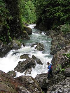 Top of canyon exit rapid 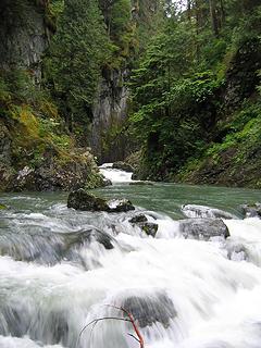 Looking upstream to large double ledge drop 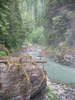 Above canyon exit rapid
Any worthwhile expedition can be planned on the back of an envelope- H. W. Tilman
Any worthwhile expedition can be planned on the back of an envelope- H. W. Tilman
|
| Back to top |
|
|
Sabahsboy
Member
Joined: 18 Jul 2006
Posts: 2484 | TRs | Pics
Location: SW Sno County |
Explain more about your photos. That looks very interesting...but how accessible is it?
|
| Back to top |
|
|
Sultan Guy
Member
Joined: 22 Jul 2008
Posts: 353 | TRs | Pics
Location: Now reinforced with Concrete |
| Sabahsboy wrote: | | Explain more about your photos. That looks very interesting...but how accessible is it? |
Pretty straightforward to get to one section of this gorge. From Olney Pass go left towards the dam. When you come to another gate you can either park here or take a right onto an old but drivable side road-USFS 6122. Take this road until you come to the large (massive) landslide which occurred in 2003. Just past this landslide is a well marked trail to the right which will take you down to the Sultan River approximately 1.25 miles below Culmback Dam. From here you can either go upstream or downstream, although you will soon be cliffed out. The trail reaches the river in one of the only few places without cliffs in the first two miles below the dam.
You can also continue on 6122 with much hard work and eventually reach the river at a really cool old log stringer bridge that still spans the river.  As I noted above there are plans in the future to make a formal trail to the river in this area.
Any worthwhile expedition can be planned on the back of an envelope- H. W. Tilman
Any worthwhile expedition can be planned on the back of an envelope- H. W. Tilman
|
| Back to top |
|
|
Scrooge
Famous Grouse

Joined: 16 Dec 2001
Posts: 6966 | TRs | Pics
Location: wishful thinking |
|
Scrooge
Famous Grouse
|
Tue Oct 07, 2008 8:00 pm |
|
|
Neat pictures, Andy. I can see where I'm going to be spending part of the winter. 
Something lost behind the ranges. Lost and waiting for you....... Go and find it. Go!
Something lost behind the ranges. Lost and waiting for you....... Go and find it. Go!
|
| Back to top |
|
|
Sultan Guy
Member
Joined: 22 Jul 2008
Posts: 353 | TRs | Pics
Location: Now reinforced with Concrete |
Any worthwhile expedition can be planned on the back of an envelope- H. W. Tilman
|
| Back to top |
|
|
Sabahsboy
Member
Joined: 18 Jul 2006
Posts: 2484 | TRs | Pics
Location: SW Sno County |
Sultan Guy, you have said it all. That road would have been a fine trail as it was. Bumpy for vehicles, great for walking. Can DNR and others submit request for funding with a budget? Sounds all too simple to fit their process.
|
| Back to top |
|
|
Scrooge
Famous Grouse

Joined: 16 Dec 2001
Posts: 6966 | TRs | Pics
Location: wishful thinking |
|
Scrooge
Famous Grouse
|
Mon Oct 27, 2008 9:17 pm We have too many Sultan Basin threads running. :irked:
|
|
|
Retraction requested.
Over in the Trip Reports forum, in The "new" trail head to Boulder lake thread, Scrooge said
| Quote: | The PUD had already been forced to reduce the scale of the recreation facilities created as part of the original licensing, because of the high maintenance costs, but it seems like the DNR could help the PUD just by doing nothing, so that things like access to Boulder and Greider Lakes and Static Point remained viable recreational options (which PUD could include in its application).
Instead, DNR has chosen to eliminate those options at the earliest possible time. It looks like they're deliberately moving fast so that those public access options cannot be included in the licensing agreement (which would then give those options federal protection for the nrxt 50 years).
The Department of Natural Resources serving the public, serving you and me.  |
After todays meeting, Andy (Sultan Guy) and Brian (hulksmash) and I spent some time talking to Stan Kurowski, DNR's representative at these meetings. In fact, Brian and I wound up talking to him for more than half an hour ( ! ) making us the last people to leave the room by a considerable margin.
We learned a lot, most importantly, that I was wrong and that the PUD's recreational interests are not connected to either DNR trails or climbers access to Static Point.  Stan had read our various forum threads on Sultan Basin; knew that we pretty much had it in for DNR; and accused one of the nwhikers of pushing a conspiracy theory (see bold-faced section of quote). I admitted that I was the author
  (although I did not agree that it was a conspiracy theory) and I hereby apologize for publicizing my erroneous conclusion. (although I did not agree that it was a conspiracy theory) and I hereby apologize for publicizing my erroneous conclusion.
 Perhaps the most interesting thing to come out of our conversation was an explanation of the huge mounds of dirt.
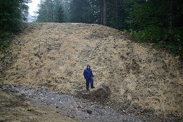 Static Point berm 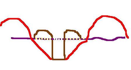 Trenches and berms  We'll be meeting with DNR sometime in January. You're invited. You can ask Stan, yourself. We'll be meeting with DNR sometime in January. You're invited. You can ask Stan, yourself. 
Something lost behind the ranges. Lost and waiting for you....... Go and find it. Go!
Something lost behind the ranges. Lost and waiting for you....... Go and find it. Go!
|
| Back to top |
|
|
Backpacker Joe
Blind Hiker

Joined: 16 Dec 2001
Posts: 23956 | TRs | Pics
Location: Cle Elum |
Thanks Scroogy.
"If destruction be our lot we must ourselves be its author and finisher. As a nation of freemen we must live through all time or die by suicide."
Abraham Lincoln
"If destruction be our lot we must ourselves be its author and finisher. As a nation of freemen we must live through all time or die by suicide."
Abraham Lincoln
|
| Back to top |
|
|
Hulksmash
Cleaning up.
Joined: 20 Apr 2008
Posts: 7113 | TRs | Pics
Location: Arlington |
|
Hulksmash
Cleaning up.
|
Mon Oct 27, 2008 10:28 pm |
|
|
As Andy just pointed out the DNR is not finished regrading the road.
So this is not exactly what the DNR envisioned as a pedristrian trail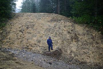 Decommissioned road in sultan basin..static point access
"Bears couldn't care less about us....we smell bad and don't taste too good. Bugs on the other hand see us as vending machines." - WetDog
Albuterol! it's the 11th essential
"Bears couldn't care less about us....we smell bad and don't taste too good. Bugs on the other hand see us as vending machines." - WetDog
Albuterol! it's the 11th essential
|
| Back to top |
|
|
|
|
You cannot post new topics in this forum
You cannot reply to topics in this forum
You cannot edit your posts in this forum
You cannot delete your posts in this forum
You cannot vote in polls in this forum
|
Disclosure: As an Amazon Associate NWHikers.net earns from qualifying purchases when you use our link(s). |


 One other very positive thing for hikers is the new trail we are likely to get built by the USFS paid for by the PUD. The USFS owns an isolated parcel of land below Culmback Dam in the Sultan River Gorge. For many years I have been exploring this gorge both by hiking and whitewater kayaking. Very stunning place with many waterfalls and rare low elevation old growth. We successfully argued that money spent on a trail for recreation was better then money spent on multiple lake recreational picnic sites that are underutilized. This new trail will be an excellent alternative for day hiking to Greider Lake. Where else do we have short easy trails to low elevation old growth that close to Seattle? I have lots of pictures of this gorge and will post some soon to this thread so everyone can see what is down there.


 Get used to hiking up and down giant ditches for the near future to access this beautiful lake TH.
  I still did not get a good reason why the abandonment and the conversion to a trail could not have been done at the same time. IMO the DNR needs to do a better job of explaining themselves and their plans in the Spada Basin.


