I have been wanting to visit this area for quite some time, having viewed it from various vantage points in the North Cascades. The timing never seemed quite right until cartman's TR from a few weeks ago finally spurred me into action!
So a couple of weeks ago, I emailed GeoTom, yukon222, and Schmidt Alti-Babe to see if they would be interested in joining me. Strangely (frightfully?) they all immediately agreed!
Many, many planning emails and other trip preparation activities later, we had things mostly squared away. The weather forecast called for a 30% of thunderstorms on Friday, then mostly sunny on Saturday, and sunny on Sunday, so those of us that owned bivies decided to save some weight and bring those in lieu of tents. Yukon222 was the sole tent bringer on this trip. Another potential problem arose as it became evident that Soapy would be joining us on this trip. Needless to say, I was somewhat apprehensive given his past history of reckless behavior and the fact that he did not participate at all in the trip preparations.
The portents of doom began immediately as a light rain greeted us upon our arrival at the Pyramid Lake trailhead. We distributed the group gear, which unfortunately included some pickets, slings, and a rope for the glacier portion of the trip. Yukon222 gamely volunteered to take the rope.
The route starts with a hike on an official trail to Pyramid Lake. The trail climbs steadily, though I didn't notice much more about it other than this because I was busy stuffing my face with huckleberries. It gains a sedate 1200' feet or so in its 2.1 mile length - a nice warm-up for what awaits once you reach the lake.
The lake. I have never seen a photo of Pyramid Lake before, and when we got there, I immediately understood why. "Lake" is an incredibly generous term for this body of water.
I've seen bodies of water that weren't even on the map that were bigger than this.
After a brief stop, we continued around the lake on a path and on up the ridge. There are a couple of different trails that branch off near the lake. We chose to follow one that had been recently flagged, and it quickly began gaining elevation, occasionally climbing up mossy slabs. I won't go into detail here as the trail is fairly hard to lose when not snow covered.
After much steep elevation gain, we broke out onto the ridge proper around 4200', where the forests thinned enough for views. The morning's rain and clouds were dispelling nicely, and we could see Pyramid Peak's impressive east face looming above.
The trail continues through steep terrain, sometimes in forest, sometimes in open meadows. We stopped to gasp for air and rest our burning quads once in a while, but the flies were just annoying enough to keep us from lingering too long.
Steve and Tom had similar expressions as Tisha, but unfortunately they saw me getting ready to take a photo and plastered on smiles. ;-)
The higher we went, the more beautiful the terrain became.
Pond on the ridge
Colonial Peak and some flowers
Tom ascends the unfortunate trail
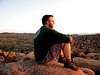
Tisha and Steve on the ridge
Right before the last elevation gain to the base of the steep face of Pyramid, we walked by a tent precariously perched right on the edge of a cliff. Its occupant(s) were nowhere in sight, yet as we continued, we did not see any tracks leading toward the tarn below Colonial Glacier. Where were these people? And who in their right mind would camp up here if they weren't going to climb something? The ridge certainly is beautiful, but there are much easier and beautiful ridges to get to!
The trail peters out for the last few hundred feet, mainly due to the fact that the ridge is more slab than vegetation, but the way is easy to find. Just go to the base of the impressive rock wall visible in this photo:
Pyramid from the ridge
Then, a tedious traverse is necessary to get to the tarn at the toe of the Colonial Glacier.
Talus/scree/snow traverse to camp
It is mostly scree, talus, and a bit of snow. We had to lose about 200' at one point in order to skirt an undermined snow bridge near a waterfall. This traverse is essentially one giant avalanche chute, so it was nice to cross it in a season where we didn't have to worry about it. Here's a photo of it I took in April from across the valley. Yikes!
traverse
We arrived at the toe of the Colonial Glacier and set up camp at the still somewhat snow-covered tarn. We were planning on ascending Pyramid Peak as it is a reasonably quick trip from here, but the weather had other ideas. Very dark clouds were quickly building. Thunder rumbled in the distance. The wind picked up. I didn't trust at all that my bivy was waterproof so I stashed it and everything else in my pack liner bag from New Zealand. Not only was the bag handy for this waterproofing purpose, but it had some very important instructions for us as well:
Important directions
We especially liked the last item on the list.
Suddenly, our choice to bring bivies seemed... impractical. This wasn't some isolated storm that would blow over in a few minutes or many even miss us entirely. We puttered around camp, waiting for impending doom. Different members of the group dealt with their anxiety in different ways:
yukon222 decided on some liquid courage:
Yukon and yukon
Schmidt Alti-babe chose more solid protection:
Tisha
GeoTom turned his back on the storm and munched on some almonds:
Tom and doom. Oh, and almonds.
Soapy wasn't anxious or nervous at all. In fact, he used this time to put up a new climbing route on a difficult slab.
Soapy making a difficult slab ascent
As the first few drops of rain hit, I headed for some larger rocks that formed an overhang of sorts that we could hide under and called to the others to join me.
Our hidey-hole, where we enjoyed hours of cowering
It started raining harder, and the lightning got closer and closer. Just for terrifying variety, the lightning and thunder were punctuated by rockfall from the cliff above us. I considered putting on my helmet, but GeoTom was right above me, so I figured he'd block any rock before it hit my head. The rain began to drip and seep into our meager shelter a bit. We watched the summit of Colonial get struck by lightning. Twice. We entertained ourselves by taking stupid videos (well, okay, that was only me), singing, complaining about the singing, and having silly conversations in general. Everyone was in amazingly good spirits given the circumstances.
It rained and thundered on. Was this ever going to stop?! Alti-Babe tried not to freeze. I tried not to starve. There was a brief break in the storm that lured us out of our hidey hole, but the respite was short and back under the rocks we went!
Overall the worst of it lasted about three hours, from 5 to 8 pm. Finally, the clouds became less threatening and there were even patches of blue sky!
Colonial after the storm has cleared
Jack in the evening
Everyone's stuff survived the downpour mostly unscathed, except for Alti-Babe's bivy. Oh, how very unwaterproof it turned out to be!
The rain stayed away during the night, but I did wake up at one point to a cloudless, starry sky that was punctuated by lightning flashes from... somewhere.
The plan for Saturday was to summit Snowfield Peak and perhaps give Colonial Peak a try as well. I got up early to catch the sunrise and was dismayed to find clouds. Oh well, the forecast was for mostly sunny, so these must just be remnants from last night. Surely they'll dissipate in a couple of hours. Right?
Well...
We ascended the Colonial Glacier to the Colonial-Neve Col on low angle and moderate slopes, skirting some glacier ice on the left side.
Steve crampons up
Ascending to Colonial-Neve Col
At the col, there is a nice view of Paul Bunyan's Stump, Pinnacle, and Pyramid, all lined up. The weather in that direction looked promising, too!
Paul Bunyan's Stump, Pinnacle, and Pyramid from Colonial-Neve Col
We also got our first look at Snowfield and the Neve Glacier from here. The col is an exposed, windy place and we didn't linger. we descended a few hundred feet onto the Neve Glacier, where we proceeded to rope up. The glacier is still fairly well covered, but some areas of crevasses are beginning to show on the route.
Tom, Snowfield, and DOOM.
As seen in this photo behind GeoTom, it was clear that the clouds were not, in fact, clearing up as the mostly sunny forecast implied. DOOM was building once again. GRRRR!!!!!
It began raining before we had even fully roped up, and we quickly unroped and found a hidey-hole for more cowering.
It was difficult to tell how big the storm was because it was coming from the east and our view was completely blocked by the ridge we'd just climbed over. At one point there was a break in the action and our eternal optimism caused us to rope up and start up the Neve Glacier in the hopes of being able to look back and see if more clouds were coming. We roped up and got about 500' horizontal feet before being once again hammered by heavy rain, thunder, lightning, etc. We fled back, unroped, and hid. AGAIN.
Well, except for Soapy, that is! That reckless frog said "to hell with it, I'm going" and proceeded up the glacier for a solo summit bid.
Unfortunately, our hiding spot was not terribly effective and streams were pouring by from all directions. Severely lacking in other options, we just shifted about, trying to avoid the worst of the running streams of water. Once again everyone remained cheerful and optimistic.
Eventually, sunshine returned, but having learned from our previous attempt, we waited instead of setting off right away. And waited. The blue patches of sky increased, and the sun stuck around, so after about half an hour of sunshine (a total delay of about three hours), we decided to make a run for it.
An hour after this photo was taken I decided to rename Snowfield Peak to Snowslog Peak.
GeoTom, our fearless leader on the glacier, picked a very efficient line toward the summit. The angle was very gentle for the most part. Very gentle. So gentle, in fact, that the suncupped surface made it a nuisance to walk straight.
We did have to skirt a few crevasses on slightly suspect snow bridges, so I'm glad we roped up!
After what seemed like an eternity of nearly flat walking, we arrived at the west ridge of Snowfield Peak. The weather to the east looked promising - some isolated clouds, but none that really yelled "IMPENDING DOOM" at us.
Thanks to cartman's route description, routefinding was generally simple once on the ridge. A few hundred feet below the summit, The Voice of Reason (aka Alti-babe) pointed out some unfriendly looking clouds to the southwest of us and wondered whether we should think about retreating. I too had seen them, but deemed them too small to be an immediate threat, plus which all of the bad weather had been coming in from the east all day, so if there are mean clouds to the southwest, what do we care?
Tom on Snowfield ridge
Descending the notch
Scrambling up to Snowfield summit
Despite my attempts at trying to traverse too far, we found the easiest route up to the summit and carefully scrambled to the top. And what do we find there? A giant storm, not visible to us from our ascent route. I took exactly one photo.
My only photo from the summit of Snowfield
Needless to say, we did not linger. The scramble down was made more interesting by the fact that it began to rain right as we left the summit.
Oh, and hail. Did I mention the hail? And the buzzing. That was not ideal, either.
Nothing like descending wet, exposed slabs and trying to outrun the lighting. Luckily the real downpour held off until we were done with the steeper rock scrambling. Back at the glacier at the base of the ridge, we found ourselves in some weird and sunny sucker hole so we took a brief food break before roping up for the descent. I went first, following our somewhat indistinct uphill bootpath.
The sucker hole closed with a bang as lightning struck the ridge around us. Being on a very open expanse, I felt very exposed. I went as fast as was possible, slowed a little by the sun cups and the increasingly bad lighting - it was getting hard to follow our ascent tracks. At one point, yukon222 and Alti-Babe reported that the pickets they were carrying began to buzz. The experience had now turned from anxiety-inducing to terrifying. There was nowhere to take shelter, so we continued on. It was a doubly memorable experience for the two of them as it was their first time being roped up on a glacier.
We unroped, though once again my mere presence caused annoying rope tangles that took a few minutes to work out before we could put the rope away. Even more unfortunately, the absolute worst of the weather seemed to be concentrated right around the Colonial-Neve Col that we needed to go through to get back to camp. Thunder and lightning were occurring at a regular and rapid rate, seemingly exactly where we wanted to go. There really wasn't a good alternative, so up and over we went. The ascent up to the col and the descent to camp went mostly without incident, though more than one of us ended up dragging our ice axe by its leash back to camp. The tingling sensation just wasn't a big draw, I guess.
Being in camp seemed safe and luxurious as we hid under the now familiar overhang and let the storm pass.
I knew another group of climbers were starting up on Saturday, so I went to look at the approach ridge to see if they had made it up. I saw the blue tent (and presumably its owner next to it) from the day before, though it had been relocated slightly.
WCN ridge camp
We made dinner, and GeoTom was kind enough to part with some of his emergency rations, thus giving me two dinners and helping me hold off starvation for a few more hours.
As I tried to go to sleep, I was serenaded by the gentle rain falling on my bivy, as well the sound of distant thunder and rockfall. Later I again woke to a starry sky and saw four shooting stars.
I once again woke up early for the sunrise and was happy to see mostly clear skies, with low valley fog making a dramatic sight.
Jack in the morning
Hozomeen and fog
Morning reflections
I decided not to be the dawn Nazi and let the others sleep in as we had no pressing matters, and we puttered around camp just enjoying the sunshine. FINALLY!
After a brief discussion, we decided to head up to Pyramid Peak. We probably had time to attempt Colonial, but from what we knew about it, we knew it would be somewhat spicy, and we'd had more than enough excitement already on this trip.
As we lazily continued preparing to leave, a group of climbers showed up at the tarn. I was expecting them, and knew a few of them, so I went over to chat and trade thunderstorm stories. They also solved the mystery about the blue tent - one of them had come up early (on Thursday) and was hanging out on the ridge waiting for the rest of the party to arrive on Saturday.
They were headed toward Snowfield Peak. One of them had been on all three of dicey's weathered out trips up here, and she was hoping the fourth time would be the charm!
Just the mere thought of ascending that trail THREE TIMES and not summitting anything makes me kind of nauseous. I wished them luck and they headed on up.
WCN crosses the tarn
Reflection and climbers
WCNers on their way up to the Colonial-Neve col
Meanwhile, we leisurely headed on up toward Pyramid Peak, basking in the sunshine. On the way up, GeoTom pointed out a bunch of new rocks that had fallen on the slopes we had ascended to the Colonial-Neve col that weren't there the day before. Of course, it couldn't be a completely mellow trip as we had one steeper snow slope with bad runout to cross before getting to easy slopes near the Pyramid summit. Oh well.
Steve traverses some steep snow
Tom gapes at the views from below the summit of Pyramid
The summit of Pyramid is a charming, wide, heather and rock covered spot with fantastic views. Having missed out on a stress free and long stay on Snowfield, we basked up here for quite some time, soaking up the views (instead of the rain, for once) and watching the climbers ascend the Neve Glacier.
Snowfield from Pyramid
Obligatory Pickets photo
Tom, Soapy, Steve, Yana, and Tisha on Pyramid summit
WCNers ascend the Neve Glacier toward Snowfield Peak
Flying saucer checks out the Spickard and Redoubt area
Hard-core summit lounging on Pyramid
We could already see thunderheads slowly forming, so eventually we moseyed on down to camp.
Descending Pyramid, Snowfield in the background
We still had a long way to go back to the car, and it was getting HOT. The traverse didn't take very long on the way back, but the sun reflecting off the talus just about killed me. Now that it was safe for them to come out, the flies and mosquitoes also showed up in full force as we descended the ridge.
Tarn, Pickets, and the rare North Cascades Flamingo
The trail was doubly hideous descending, especially since it was wet from all the rain. This is possibly the worst climbers' path I have ever been up. Somewhere in the lower portion, I accidentally got off the path we had come up. Unfortunately, I didn't realize this right away because I was still following pretty distinct boot tread. We figured there couldn't possibly be a trail up here that didn't go to Pyramid Lake, so we decided against retracing our steps uphill and followed the path down. It was the scenic route and deposited us atop a cliff above Pyramid Lake.
The mighty Pyramid Lake from above
This path is not as well beaten in but it does avoid some of the climbing up mossy slabs present in the other trail. Now we just had two miles of "normal" trail back to the car. We snacked on more huckleberries on the way down, visions of milkshakes keeping us going in the hot, dusty weather.
We made it down some time after 5 pm, tired but pleased. On the drive out, we looked back at the massive thunderstorms that looked to be swallowing the mountains. It was nice to see them from the outside instead of the inside!
After a gratifying stop for milkshakes (we all ordered raspberry - I think spending so much time huddled under rocks with one another melded our brains together ), we made the long drive back to Pugetopolis. Well, yukon222 drove. The rest of us just gawked at the storm clouds out the window and basked in the memories of our trip.
Though I would have preferred a less electrifying experience, this turned out to be a pretty good trip. Thanks to my partners in crime for agreeing to come and for remaining in excellent spirits throughout our various trials!
I'll have to come back for Colonial. Some day. Some day in the distant future.
PLAY SAFE! SKI ONLY IN CLOCKWISE DIRECTION! LET'S ALL HAVE FUN TOGETHER!
0
PLAY SAFE! SKI ONLY IN CLOCKWISE DIRECTION! LET'S ALL HAVE FUN TOGETHER!
"If destruction be our lot we must ourselves be its author and finisher. As a nation of freemen we must live through all time or die by suicide."
Abraham Lincoln
0
"If destruction be our lot we must ourselves be its author and finisher. As a nation of freemen we must live through all time or die by suicide."
Abraham Lincoln
Thanks for writing the TR Yana. I'll have to finish sorting through my photos and post a few tonight.
Unfortunately we left pretty early on Friday and were not able to see the thunderstorm warning that was posted later. Still, it was a good trip with some good people and a somewhat reckless frog. I had been talking about getting into this area someday, and now I have.
A few thoughts:
I might be a terrible singer, but at least it provided a small amount of entertainment while we were huddled under the rocks.
Group size is limited to 6 in this area. Apparently this rule does not apply to flies.
My bivy is waterproof (for now), but a tent would have been nicer to lounge in while waiting out the storm.
I need to make sure I count the fuel bottles I put into my pack. Bringing two extras as training weight really isn't necessary, or welcome.
Bringing extra food for Yana is good. She will hate you slightly less than before.
I still would like to climb Colonial Peak, but will not go up or down that approach trail for at least 5 years. Anyone want to join me in late July 2014?
Thanks for the invite, Yana! I think.
The climbers' bootpath above Pyramid Lake has a few spicy moments if one is hauling a large overnight backpack. Either branches from below, the side or above have a tendency to grab onto you at inopportune moments. Not too bad when dry; a little exciting in spots when the mossy outward sloping slabs are wet from heavy rains.
First time out on a glacier. Very interesting experience. Two of the crevasse crossings were eye opening as the snowbridges were at 45° side angle so you had to zig zag over the snowbridge without letting the forward or trailing rope pull you off your intended travel line. A quick glimpse at the dark depths below and I was happy to not have to test out my Prussik lines.
Snowfield Peak finished with a fun rock scramble. The notch in the ridge has a decent sized drop if one was careless. If the rock was wet, it would be a bit tricky as the key slab slopes outward towards a 40' drop. Too bad we had to flee the summit after only 2 minutes. It looked like the views could be tremendous.
I took plenty of pictures (some even NOT of the rain and dark ominous clouds ) and hope to post them late tonight or tomorrow. GPS said the trip was a bit over 19 miles and 10,900' gain.
Thanks again for the trip; excellent group of people to spend holed up beneath rocks for hours on end with rain, lightning and thunder flying around.
Holy Crap you guys! Remind me never to go on a trip Yana dreams up...
I don't think anybody got much warning about those storms. Down in Maple Falls, I'd checked the weather Fri morning and it just said partly sunny. It wasn't until we saw the really ominous clouds forming that anybody thought to check the NWS site again and saw the severe thunderstorm warnings.
Gorgeous pics, looks like quite a journey, I love that there are so many places like this to explore in Washington. Sucker holes suck! And I love being Dawn Nazi! Its the best time of the morning, my experience is Yukon has a bit too much Yukon to get up early.
I demand that more storm videos be posted! Glad you guys had an "enlightening" time in the North Cascades.
(And for the record, we had not one drop of rain/thunder/lightning on us at Rainier on Saturday. So hah. )
Very nice, I watched the NOAA forecast go from full sunshine around Black to mostly cloudy and t-storms for both days, then I looked at Shuksan and it was still looking good, then it deteriorated, so a quick change in the forecast, especially Friday. Great job under adverse conditions, sounds like you guys were really "Amped up".
Hah, we were happily ensconced in our house on Friday night thinking of you guys shivering in your little bivies high up on the mountain.
Fine, so we were actually a little worried. I'm glad you're all ok. I had visions of Soapy being struck by lightning and melting.
Moar pitchers!
....crevasse crossings were eye opening as the snowbridges were at 45° side angle so you had to zig zag over the snowbridge without letting the forward or trailing rope pull you off your intended travel line. A quick glimpse at the dark depths below and I was happy to not have to test out my Prussik lines......
...... GPS said the trip was a bit over 19 miles and 10,900' gain.....
You could have done Rainier, that was our round trip on the Emmons route.
As a student of "doom" myself, I appreciate your nuanced exploration of its many intricate levels:
- impending doom
- IMPENDING DOOM
- doom
- almond doom
- buzzing hail doom
- DOOM
- rock cowering doom
- brain-meld doom milkshakes
Sweet! A veritable cornucopia of doom-laden adventure!
Seriously, so glad you all made it up and down with out a shock or fall off Paul's Stumpy Bunion. Phew! Looking forward to seeing all the pics!
You cannot post new topics in this forum You cannot reply to topics in this forum You cannot edit your posts in this forum You cannot delete your posts in this forum You cannot vote in polls in this forum
Disclosure: As an Amazon Associate NWHikers.net earns from qualifying purchases when you use our link(s).


 The portents of doom began immediately as a light rain greeted us upon our arrival at the Pyramid Lake trailhead. We distributed the group gear, which unfortunately included some pickets, slings, and a rope for the glacier portion of the trip. Yukon222 gamely volunteered to take the rope.
  The route starts with a hike on an official trail to Pyramid Lake. The trail climbs steadily, though I didn't notice much more about it other than this because I was busy stuffing my face with huckleberries. It gains a sedate 1200' feet or so in its 2.1 mile length - a nice warm-up for what awaits once you reach the lake.
The lake. I have never seen a photo of Pyramid Lake before, and when we got there, I immediately understood why. "Lake" is an incredibly generous term for this body of water.
The route starts with a hike on an official trail to Pyramid Lake. The trail climbs steadily, though I didn't notice much more about it other than this because I was busy stuffing my face with huckleberries. It gains a sedate 1200' feet or so in its 2.1 mile length - a nice warm-up for what awaits once you reach the lake.
The lake. I have never seen a photo of Pyramid Lake before, and when we got there, I immediately understood why. "Lake" is an incredibly generous term for this body of water.


 It rained and thundered on. Was this ever going to stop?! Alti-Babe tried not to freeze. I tried not to starve. There was a brief break in the storm that lured us out of our hidey hole, but the respite was short and back under the rocks we went!
Overall the worst of it lasted about three hours, from 5 to 8 pm. Finally, the clouds became less threatening and there were even patches of blue sky!
It rained and thundered on. Was this ever going to stop?! Alti-Babe tried not to freeze. I tried not to starve. There was a brief break in the storm that lured us out of our hidey hole, but the respite was short and back under the rocks we went!
Overall the worst of it lasted about three hours, from 5 to 8 pm. Finally, the clouds became less threatening and there were even patches of blue sky!


 The rain stayed away during the night, but I did wake up at one point to a cloudless, starry sky that was punctuated by lightning flashes from... somewhere.
  The plan for Saturday was to summit Snowfield Peak and perhaps give Colonial Peak a try as well. I got up early to catch the sunrise and was dismayed to find clouds. Oh well, the forecast was for mostly sunny, so these must just be remnants from last night. Surely they'll dissipate in a couple of hours. Right?
Well...
We ascended the Colonial Glacier to the Colonial-Neve Col on low angle and moderate slopes, skirting some glacier ice on the left side.
The plan for Saturday was to summit Snowfield Peak and perhaps give Colonial Peak a try as well. I got up early to catch the sunrise and was dismayed to find clouds. Oh well, the forecast was for mostly sunny, so these must just be remnants from last night. Surely they'll dissipate in a couple of hours. Right?
Well...
We ascended the Colonial Glacier to the Colonial-Neve Col on low angle and moderate slopes, skirting some glacier ice on the left side.


 Unfortunately, our hiding spot was not terribly effective and streams were pouring by from all directions.
  Severely lacking in other options, we just shifted about, trying to avoid the worst of the running streams of water. Once again everyone remained cheerful and optimistic.


 Oh, and hail. Did I mention the hail? And the buzzing. That was not ideal, either.
Nothing like descending wet, exposed slabs and trying to outrun the lighting. Luckily the real downpour held off until we were done with the steeper rock scrambling. Back at the glacier at the base of the ridge, we found ourselves in some weird and sunny sucker hole so we took a brief food break before roping up for the descent. I went first, following our somewhat indistinct uphill bootpath.
The sucker hole closed with a bang as lightning struck the ridge around us. Being on a very open expanse, I felt very exposed. I went as fast as was possible, slowed a little by the sun cups and the increasingly bad lighting - it was getting hard to follow our ascent tracks. At one point, yukon222 and Alti-Babe reported that the pickets they were carrying began to buzz.
Oh, and hail. Did I mention the hail? And the buzzing. That was not ideal, either.
Nothing like descending wet, exposed slabs and trying to outrun the lighting. Luckily the real downpour held off until we were done with the steeper rock scrambling. Back at the glacier at the base of the ridge, we found ourselves in some weird and sunny sucker hole so we took a brief food break before roping up for the descent. I went first, following our somewhat indistinct uphill bootpath.
The sucker hole closed with a bang as lightning struck the ridge around us. Being on a very open expanse, I felt very exposed. I went as fast as was possible, slowed a little by the sun cups and the increasingly bad lighting - it was getting hard to follow our ascent tracks. At one point, yukon222 and Alti-Babe reported that the pickets they were carrying began to buzz.  The experience had now turned from anxiety-inducing to terrifying. There was nowhere to take shelter, so we continued on. It was a doubly memorable experience for the two of them as it was their first time being roped up on a glacier.


 After a brief discussion, we decided to head up to Pyramid Peak. We probably had time to attempt Colonial, but from what we knew about it, we knew it would be somewhat spicy, and we'd had more than enough excitement already on this trip.
As we lazily continued preparing to leave, a group of climbers showed up at the tarn. I was expecting them, and knew a few of them, so I went over to chat and trade thunderstorm stories. They also solved the mystery about the blue tent - one of them had come up early (on Thursday) and was hanging out on the ridge waiting for the rest of the party to arrive on Saturday.
They were headed toward Snowfield Peak. One of them had been on all three of dicey's weathered out trips up here, and she was hoping the fourth time would be the charm!
Just the mere thought of ascending that trail THREE TIMES and not summitting anything makes me kind of nauseous.
After a brief discussion, we decided to head up to Pyramid Peak. We probably had time to attempt Colonial, but from what we knew about it, we knew it would be somewhat spicy, and we'd had more than enough excitement already on this trip.
As we lazily continued preparing to leave, a group of climbers showed up at the tarn. I was expecting them, and knew a few of them, so I went over to chat and trade thunderstorm stories. They also solved the mystery about the blue tent - one of them had come up early (on Thursday) and was hanging out on the ridge waiting for the rest of the party to arrive on Saturday.
They were headed toward Snowfield Peak. One of them had been on all three of dicey's weathered out trips up here, and she was hoping the fourth time would be the charm!
Just the mere thought of ascending that trail THREE TIMES and not summitting anything makes me kind of nauseous. 


 Of course, it couldn't be a completely mellow trip as we had one steeper snow slope with bad runout to cross before getting to easy slopes near the Pyramid summit. Oh well.


 After a gratifying stop for milkshakes (we all ordered raspberry - I think spending so much time huddled under rocks with one another melded our brains together


 The climbers' bootpath above Pyramid Lake has a few spicy moments if one is hauling a large overnight backpack. Either branches from below, the side or above have a tendency to grab onto you at inopportune moments. Not too bad when dry; a little exciting in spots when the mossy outward sloping slabs are wet from heavy rains.
First time out on a glacier. Very interesting experience. Two of the crevasse crossings were eye opening as the snowbridges were at 45° side angle so you had to zig zag over the snowbridge without letting the forward or trailing rope pull you off your intended travel line. A quick glimpse at the dark depths below and I was happy to not have to test out my Prussik lines.
Snowfield Peak finished with a fun rock scramble. The notch in the ridge has a decent sized drop if one was careless. If the rock was wet, it would be a bit tricky as the key slab slopes outward towards a 40' drop. Too bad we had to flee the summit after only 2 minutes. It looked like the views could be tremendous.
I took plenty of pictures (some even NOT of the rain and dark ominous clouds
The climbers' bootpath above Pyramid Lake has a few spicy moments if one is hauling a large overnight backpack. Either branches from below, the side or above have a tendency to grab onto you at inopportune moments. Not too bad when dry; a little exciting in spots when the mossy outward sloping slabs are wet from heavy rains.
First time out on a glacier. Very interesting experience. Two of the crevasse crossings were eye opening as the snowbridges were at 45° side angle so you had to zig zag over the snowbridge without letting the forward or trailing rope pull you off your intended travel line. A quick glimpse at the dark depths below and I was happy to not have to test out my Prussik lines.
Snowfield Peak finished with a fun rock scramble. The notch in the ridge has a decent sized drop if one was careless. If the rock was wet, it would be a bit tricky as the key slab slopes outward towards a 40' drop. Too bad we had to flee the summit after only 2 minutes. It looked like the views could be tremendous.
I took plenty of pictures (some even NOT of the rain and dark ominous clouds 


 )
)

 Seriously, so glad you all made it up and down with out a shock or fall off Paul's Stumpy Bunion. Phew! Looking forward to seeing all the pics!