| Previous :: Next Topic |
| Author |
Message |
goats gone wild
Mr. Goat


Joined: 19 Aug 2007
Posts: 2524 | TRs | Pics
Location: Vampireville |
.....leaving me wanting to return over and over in what ever capacity that may be, even if one day my knees are too old and I can only see the mountains from my porch.
Jason Hummel
|
| Back to top |
  
|
|
silence
Member

Joined: 25 Apr 2005
Posts: 4420 | TRs | Pics
|
|
silence
Member
|
 Sat Aug 22, 2009 1:45 pm |
|
|
some photos of christie fm an unexpected trip to martins park this past weekend which might be helpful
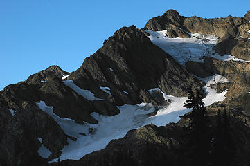 Christie's Couloirs 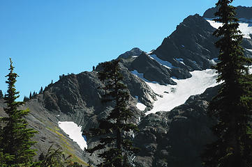 Mount Christie's Northeast Rib 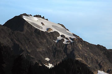 Mt Queets from Martins Park 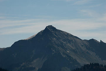 Chimney Peak from Martins Park 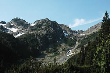 2 labels Mts Seattle and Noyes from Elwha Basin Camp 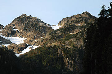 Mts Seattle and Noyes Closeup
PHOTOS
FILMS
Keep a good head and always carry a light bulb. Bob Dylan
PHOTOS
FILMS
Keep a good head and always carry a light bulb. Bob Dylan
|
| Back to top |
|
|
Greybeard
Member

Joined: 13 Jul 2010
Posts: 1 | TRs | Pics
Location: Storrs, CT |
|
Greybeard
Member
|
Tue Jul 13, 2010 2:17 pm Godkin-Buckinghorse Ridge
|
|
|
I chanced upon this post when I was looking into the feasibility of hiking the Mt. Delabarre ridge from Martins Park to the Godkin-Rustler divide.
My wife and I hiked the Godkin-Buckinghorse ridge to the Godkin-Rustler saddle in July 1976 as part of an 11-day loop from Dosewallips. Starting from below Camp Wilder on the Elwha and ending at Enchanted Valley on the E. Fork of the Quinault required 3 days of hiking. We saw nobody else on this X-C part of our trip.
I recall the ascent of the Godkin-Buckinghorse ridge being very unpleasantly steep, with a couple of slips fortunately arrested by ice axe. We climbed up the N. end of the ridge, traversing W. when necessary to avoid cliffs. (It would probably make more sense to ascend the S. side of the NW-SE ridge that leads to 5010T on the Chimney Pk. 7.5' quad, particularly since this peak is difficult to pass (on the W.) from the N.) Our first day ended just N. of 5451T, where we descended a bit to a more-or-less level campsite with water. (We had found no water to this point on the ridge.)
A little scouting the next morning revealed a break in the cliff that rises across the drainage N. of 5451T -- a short chute at the top of a brushy slope. Once through the cliff, it was easy to regain the ridge, passing the two buttresses 5329T (running water below it) and 5235T on the W. From the pass between Buckinghorse and Godkin, my notes indicate that we descended a bit (probably on the S. side) and then followed game trails up onto a ridge above the Godkin-Rustler saddle, to which we then descended to our second campsite, where we spent two nights.
Our descent to the E. Fork was via Pyrites Creek. I had expected to hit the trail shown on the old 15' Mt. Steel quad, but we found only reassuring fragments of it, one of them where it crossed the second stream coming down from 6049T. I recall that the descent, though long, was not bad -- at least compared to getting up the Godkin-Buckinghorse ridge. You can see from the Chimney Pk. topo that it is not super-steep.
The Godkin-Rustler saddle is a lovely area. I think there are probably easier -- not to say easy -- ways to get there than the one we chose.
|
| Back to top |
|
|
Lotus54
Member

Joined: 17 Oct 2010
Posts: 381 | TRs | Pics
Location: Port Angeles |
|
Lotus54
Member
|
Fri Nov 12, 2010 9:58 am |
|
|
Just stumbled on this.
I've done from Martins Park to Quinault. At the time we heard going over the top isn't too bad with a lot of snow, but not a lot of fun otherwise. We tried to stay fairly high, but below cliffs. We couldn't do it (see pics I posted in other thread). We dropped down to the old Rustler trail (still found quit a lot of sign at the time), then followed a killer Elk trail to Godkin pass.
an easy traverse over to Pyrites, then dropped down and picked up the old trail. Pretty easy to find back then.
We went from Low Divide to Enchanted Valley in two days. first day was a bit long, since we wasted a lot of time trying to stay high.
Mark
|
| Back to top |
|
|
|
|
You cannot post new topics in this forum
You cannot reply to topics in this forum
You cannot edit your posts in this forum
You cannot delete your posts in this forum
You cannot vote in polls in this forum
|
Disclosure: As an Amazon Associate NWHikers.net earns from qualifying purchases when you use our link(s). |


