Forum Index > Trip Reports > Tom, Dick, Harry, and me 8/18/09
 Reply to topic
Previous :: Next Topic
Author Message
whitebark
Member
Member


Joined: 08 Jul 2005
Posts: 1864 | TRs | Pics
Location: Seattle
whitebark
Member
PostTue Aug 18, 2009 8:54 pm 
Imagine the most beautiful lake that you've ever been to...clear, wind-rippled waters full of trout, rocky coves surrounded by groves of storm-sculpted alpine firs, a backdrop of rugged, snowy peaks. Well, the Tom Dick and Harry Lakes don't have any of that stuff. But they have a cool name and that's good enough for me! To get to TD&H lakes, I drove to Index then continued on the N. Fork Skykomish road a few miles farther to the start of the Bitter Creek logging road. I parked by the gate where there is room for about two cars. Elevation at this spot was a depressing 850' above sea level. The first two miles of the road offered easy and pleasant hiking in shady forest. The road looked like it was getting a bit of foot traffic and brush was minimal. The easy going ended at 1600', where a massive debris flow had wiped out a section of the road.
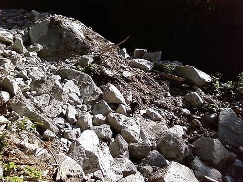
Washout, Bitter Creek road
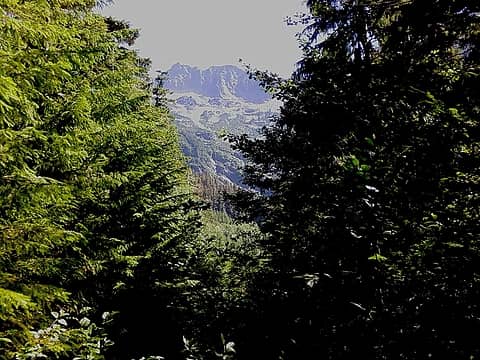
Beyond the rock slide the road became distinctly steeper and brushier, although not enough to impede progress. A series of 6 switchbacks took the road up to 2100', then it made an ascending traverse into the Bitter Creek canyon. In the 80's this part of the road offered spectacular views, but it is so overgrown now that only frustratingly limited peeks out to the Skykomish River canyon are all that is available. At 2400' the road passed by a talus slope of massive granite blocks fallen from a cliff, a nice change of scenery from all the trees. Then it descended to a crossing of Bitter Creek. The creek was too brushy for humans to enjoy, but Lex the dog took a much needed bath in its cool waters. From the creek, the deteriorating road resumed climbing toward the elusive TD&H lakes. Branches in the road and brush-obscured switchbacks made this part a bit confusing. I was expecting to see some ribbons put up by the fisherman anxious to get to the giant trout living in the lakes (possibly) but none were to be seen...As far as navigation was concerned, I was on my own. The Bitter Creek Cirque is a rather impressive spot, but you can hardly see it from the road anymore. This is about as good a view as one gets:
Bitter Creek Cirque
Bitter Creek Cirque
At 2900' I finally ran out of road. Ahead was old growth forest, which promised fairly easy going to the lakes, the first of which (Tom Lake?) was only a half mile away. Heading into the forest, I indeed found the cross-country travel to be not particularly difficult, although navigation on the deep forest was a bit tricky. I veered too far to the south and ran into a brushy rockslide. My Garmin Legend Cx quickly resolved the difficulty, although not after I managed to step in a bee nest and was stung several times (aah, the joys of late summer hiking). At 3200 feet the terrain became almost level and I found myself in an area especially magnificent subalpine old growth forest. Wonder what stopped the Forest Service from logging up here? I saw a bright area ahead through the trees, and I knew I had Tom Lake in the bag. In my head were visions of myself taking a nice swim in the lake's crystalline waters, then drying off in the sun while marveling at the alpine splendor of its setting. A few steps up a wooded draw and there it was...Tom Lake...and a major letdown:
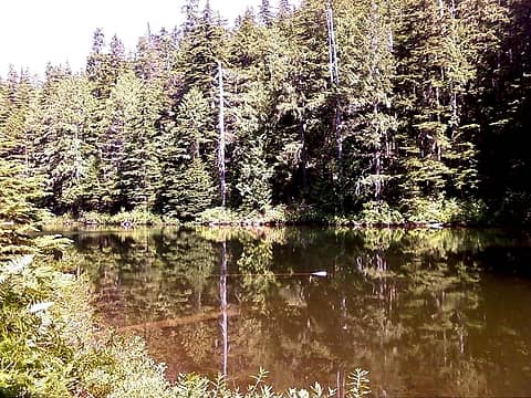
The first Tom Dick and Harry lake
In disbelief I consulted my GPS, hoping there was some kind of mistake. But no, this was the lake. At least Lex seem to enjoy wading around in the murky water. There was no sign that anyone had visited the lake or camped there. I pondered whether I should try to reach Dick and Harry Lakes, but decided there was not much point in doing so. Back at the comfort of home, I'm starting to regret not looking for the three other TD&H lakes. Even if the lakes are not much, the deeply wooded plateau that the lakes are located on is a unique spot. There is not too much to recommend about this hike. Due to its low starting elevation, the bitter creek road might be a good spring walk.
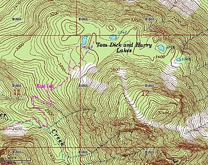
Route to Tom Dick and Harry Lakes

Back to top Reply to topic Reply with quote Send private message
Bedivere
Why Do Witches Burn?


Joined: 25 Jul 2008
Posts: 7464 | TRs | Pics
Location: The Hermitage
Bedivere
Why Do Witches Burn?
PostTue Aug 18, 2009 9:05 pm 
I've fished in Trout Creek a number of times and noted those lakes high up on the ridge. They're so small, I kind of figured they'd be about like what you found. You're certainly the first person I've ever heard of who's gone there. Thanks for the report!

Back to top Reply to topic Reply with quote Send private message
   All times are GMT - 8 Hours
 Reply to topic
Forum Index > Trip Reports > Tom, Dick, Harry, and me 8/18/09
Jump to:   
Search this topic:

You cannot post new topics in this forum
You cannot reply to topics in this forum
You cannot edit your posts in this forum
You cannot delete your posts in this forum
You cannot vote in polls in this forum