| Previous :: Next Topic |
| Author |
Message |
boomheist
Member


Joined: 25 Jul 2009
Posts: 55 | TRs | Pics
Location: tacoma |
Does anyone know anything about when the first trails were cut into the Olympics? Between the Press expedition going through in the 1890s and the Camp Parsons hiking trips of the mid 1920s (when there were trails as far as I can tell pretty much throughout the northern and eastern Olympics area, and the south, too) most of the basic trails were cut, and I am curious how that happened. Was it with a group or groups, like the Mountaineers, or individuals, or trappers and homesteaders? It all happened pretty fast, I am guessing in twenty years or less, and I am guessing it's because there were maybe half a dozen people who just fell in love with the country and did it, but maybe there is actual data rather than a guess....Could there be some books written that document this work?
Update 6/21/16: Geepers. In the almost 7 years since this first post there have been a whole lot of great comments ranging from, on the one hand, native peoples never went into the interior to, on the other, they have been wandering the high country and rivers forever. One of the most common legends among native peoples along the Pacific Northwest coast is they have been here forever, since before time. This of course contradicts current human origins theory (out of Africa or Eurasia). But I think the legends may be true. I developed this theory in 2010, then did a pile of research, and have been writing this tale based on the theory. https://charliesheldon2.com/2017/02/06/the-north-pacific-coast/ .....and in the meantime when I go into the back country, which hasn't been as often as I'd like due to work demands far away in recent years, I like to imagine I am trodding on a path made by people thousands, and thousands, of years ago....and if I am right - and I believe I am - then whoever those brave and intrepid first trail cutters in the early years of the 20th century were, they stood on the shoulders of ancient and long departed people who ranged this beautiful land in the time of great ice and terrible animals....
|
| Back to top |
  
|
|
Malachai Constant
Member

Joined: 13 Jan 2002
Posts: 16092 | TRs | Pics
Location: Back Again Like A Bad Penny |
assume some of the trails were made for the lodges. There was a large lodge at Sol Duk Hot Springs and both the Quinault and Lake Crescent LodgChalet in the Enchanted Valley was originally a comercial operation. There were home steaders in the Hoh, Queets and Quinault Valleys who were relocated after the National Park I assume they built some of the trails.
"You do not laugh when you look at the mountains, or when you look at the sea." Lafcadio Hearn
"You do not laugh when you look at the mountains, or when you look at the sea." Lafcadio Hearn
|
| Back to top |
|
|
bobbi
stillaGUAMish

Joined: 13 Jul 2006
Posts: 8012 | TRs | Pics
Location: olympics! |
|
bobbi
stillaGUAMish
|
 Sun Dec 13, 2009 9:27 am |
|
|
hubby believes that some of the trails were blazed by the CCC.
bobbi ૐ
"Today is your day! Your mountain is waiting. So
get on your way!" - Oh, the Places Youll Go! By Dr. Seuss
bobbi ૐ
"Today is your day! Your mountain is waiting. So
get on your way!" - Oh, the Places Youll Go! By Dr. Seuss
|
| Back to top |
|
|
reststep
Member
Joined: 17 Dec 2001
Posts: 4757 | TRs | Pics
|
|
reststep
Member
|
Sun Dec 13, 2009 12:14 pm |
|
|
Robert L. Wood has some information on the early trail system in his "Olympic Mountains Trail Guide". This is the 1985 version and starts on page 13.
He states that "During the 1930s the Civilian Conversation Corps constructed a number of trails for the Forest Service."
He talks some about earlier trails also.
I have read about the Seattle Mountaineers getting trails built special for their early outings. I cannot recall at this time where I read this.
Wood also mentions "Jim Taplin's Olympic Trail Guide, a map published in 1930, shows the trail system in the Olympics as it was more than half a century ago."
I wonder if there are any more of those in existence.
"The mountains are calling and I must go." - John Muir
"The mountains are calling and I must go." - John Muir
|
| Back to top |
|
|
Phil
Member

Joined: 02 Jul 2003
Posts: 2025 | TRs | Pics
Location: Shoreline, WA |
|
Phil
Member
|
Sun Dec 13, 2009 9:09 pm |
|
|
Boom, a few key sources have already been mentioned. I'll add my opinion that the earliest trails weren't carefully documented in the sense we think of documentation today. When the Press and Oneil expeditions went into the Olympics they came across locations where hunting, mining or various human operations were in recent or current operation. So in terms of european forays into those mountains I think it's anyone's guess how many folks went there and when they did, but suffice to say they were hunting and surveying for minerals pretty early on.
Read Wood and other sources and they suggest that native people didnt go into the Olympics. Some BS story about native people being afraid of Thunderbird in the mountains or something like that. I think that's just a ploy to make the newspaper-sponsored expeditions seem that much more adventurous. I also I think the evidence is more in favor of the scenario where the native people had plenty of trips into the mountains, even deep in. For resources, trade, etc. Heck, even just to go see what's in those hills, ordinary human curiosity. For example, Elmindorf's research notes that Quinalt and Skokomish would meet seasonally at one of the divides, he speculates at the headwaters of the Skokomish. Olympic National Park has a number of archeological sites pretty far in, 7 lakes basin and over by Grand Valley is what I recall.
Anyway, if you want to read more on early ventures into the Olympics, here are some other ideas:
1) Drop by the local museum in Shelton, right on the main street. You can buy some great historical society booklets about mining and homesteading in the SE olympics. I bet same can be said of the museum in Port Angeles.... never been there myself.
2) Get books by the anthropologist Elmendorf:
Twana Culture, Twana Narratives. He and his subjects seemed most interested in religion, etc., which makes for great reading, but you can read about old trails and settlements in his books, there is even a fantastic map of the old skok valley villages and trails.
3) start digging around in the King County library system if you can. I recommend Chris Morgenroth's autobiography, Footprints in the Olympics, it includes some very old annotated maps and general narrative about settlement on the west side. All in all a good read about a green german kid that came to america and made good.
Also books about Herb Crisler, Huelsdonk "Iron Man of the Hoh" to name a couple leads.
|
| Back to top |
|
|
weatherman
climatologist

Joined: 09 Feb 2007
Posts: 658 | TRs | Pics
Location: Seattle |
|
weatherman
climatologist
|
Wed Jan 06, 2010 10:55 pm |
|
|
I highly recommend Carsten Lien's book "Olympic battleground : the power politics of timber preservation", for a general overview of the history of Olympic National Park. But I don't recall this book spending much time on the history of trail building in what is now Olympic NP. It would be interesting to know how many of the trails were built after the establishment of the park in 1938.
|
| Back to top |
|
|
strider
Member
Joined: 24 Aug 2002
Posts: 464 | TRs | Pics
Location: Silverdale |
|
strider
Member
|
Thu Jan 07, 2010 2:18 pm |
|
|
There's a lot of new and interesting things accessable via the WINDSOX website. The entire contents of the book "Trails and Trials of the Pioneers" by Lucile Cleland can be found herre:
http://www.windsox.us/PIONEERS/BOOK/C.html
It's a wonderful collection of stories and accounts assembled about and by the Humptulips Pioneer Association.
strider
I've never been lost, but I'm frequently uncertain where my destination might be in relation to where I am at the moment....
strider
I've never been lost, but I'm frequently uncertain where my destination might be in relation to where I am at the moment....
|
| Back to top |
|
|
RodF
Member

Joined: 01 Sep 2007
Posts: 2593 | TRs | Pics
Location: Sequim WA |
|
RodF
Member
|
Sat Jan 30, 2010 6:03 pm |
|
|
| boomheist wrote: | | Does anyone know anything about when the first trails were cut into the Olympics?... |
Wood's Olympic Mountain Trail Guide says (page 24)
| Quote: | | About this time [1850s] prospectors and hunters began roaming throughout the Olympics, but they left no records or trails.
The first organized attempt to explore the Olympic Mountains occurred in 1882, when the U.S. Army cut a trail from Fort Townsend, on the NE tip of the Olympic peninsula, to the Dungeness River. The soldiers were followed, three years later, by an expedition commanded by Lt. Joseph P. O'Neil that explored the northeastern Olympics. |
(This only whetted his appetite - O'Neil would return in 1890 to organize and lead the first thorough exploration of the Olympics.)
I found a map depicting this first "built" trail in the Olympics in the WSU library entitled Olympic forest reserve, Washington (1902). Notice the "MILITARY TRAIL" coming west down Gold Creek almost to the Dungeness River. The trail must have come over Bon Jon Pass, where FS 28 road now runs.
This map, available online, shows only a few other trails in the Olympics in 1902: N Fk Quinault to Elip Creek, Elip Creek, Quinault to Evergreen to Queets to Clearwater R and up Christmas Creek (on and just east of later Hwy 101 route), and some coastal trails. It doesn't even show the Elwha trail, which we know existed then, but concentrates on logging potential. It must have been based on the amazing Dodwell-Rixon survey, published in 1900, also available online.
The Olympic National Forest, Washington (1911) map does show the Elwha Trail, Wolf Creek - Cox Valley - Obstruction Point trails, Big Quilcene - Tubal Cain - Little Quilcene trails, lower Dosewallips and Duckabush wagon roads, wagon road from Hoodsport and trail from Lilliwaup to Cushman, trails up the lower north and south fork Skokomish, Wynoochee and Humptulips, the lower N Fk Quinault to Elip Creek, Queets wagon road up to Spruce Bottom, lower Hoh to the forks of the main/south forks, the Sol Duc Trail, and a loop trail around the entire Olympics approximating the later Hwy. 101 route. (The ones in bold survive as important trails today.)
"of all the paths you take in life, make sure a few of them are dirt" - John Muir
"the wild is not the opposite of cultivated. It is the opposite of the captivated - Vandana Shiva
"of all the paths you take in life, make sure a few of them are dirt" - John Muir
"the wild is not the opposite of cultivated. It is the opposite of the captivated - Vandana Shiva
|
| Back to top |
|
|
RodF
Member
Joined: 01 Sep 2007
Posts: 2593 | TRs | Pics
Location: Sequim WA |
|
RodF
Member
|
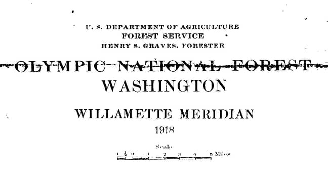
Sat Jan 30, 2010 6:07 pm 1918 Olympic National Forest map
|
|
|
This 1918 Olympic National Forest map is the earliest published trail map of the interior Olympics in the Park archives. (Thanks to Gay Hunter, ONP Archivist, for sharing it.) For higher resolution, see the original scans posted here, and click on the magnifying glass icon or download them to your computer.
 title 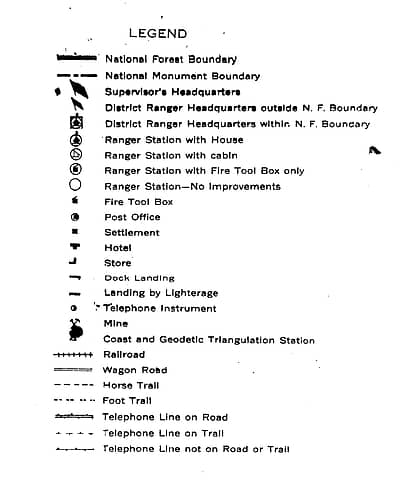 legend
"of all the paths you take in life, make sure a few of them are dirt" - John Muir
"the wild is not the opposite of cultivated. It is the opposite of the captivated - Vandana Shiva
 jonreedna@yahoo.com jonreedna@yahoo.com
"of all the paths you take in life, make sure a few of them are dirt" - John Muir
"the wild is not the opposite of cultivated. It is the opposite of the captivated - Vandana Shiva
jonreedna@yahoo.com
|
| Back to top |
|
|
Phil
Member
Joined: 02 Jul 2003
Posts: 2025 | TRs | Pics
Location: Shoreline, WA |
|
Phil
Member
|
Sun Jan 31, 2010 11:09 am |
|
|
Great maps Rod.  N Fork Skokomish section is intrigueing for showing trails not apparently in existence today. You can see the old west side route past Four Stream, drawn to apparently cross to the east side just downstream of the Six Stream canyons. Then the trail stays on east side before crossing almost all the way to Hammer creek, whereas today it crosses sooner.
I'm going to have to check out the terrain in those areas some day.
N Fork Skokomish section is intrigueing for showing trails not apparently in existence today. You can see the old west side route past Four Stream, drawn to apparently cross to the east side just downstream of the Six Stream canyons. Then the trail stays on east side before crossing almost all the way to Hammer creek, whereas today it crosses sooner.
I'm going to have to check out the terrain in those areas some day.
|
| Back to top |
|
|
Phil
Member
Joined: 02 Jul 2003
Posts: 2025 | TRs | Pics
Location: Shoreline, WA |
|
Phil
Member
|
Sun Jan 31, 2010 11:19 am Re: 1918 Olympic National Forest map
|
|
|
| RodF wrote: | | Just as surprising are some of the trails not depicted, that I'd assumed existed earlier than some of the above:
O'Neil Pass etc etc |
Add to that list the network of trails related to Tubal Caine mining operations.
|
| Back to top |
|
|
RodF
Member
Joined: 01 Sep 2007
Posts: 2593 | TRs | Pics
Location: Sequim WA |
|
RodF
Member
|
Sun Jan 31, 2010 3:10 pm |
|
|
| reststep wrote: | | Wood also mentions "Jim Taplin's Olympic Trail Guide, a map published in 1930, shows the trail system in the Olympics as it was more than half a century ago." |
There's a poor-quality photocopy in the ONP Archive, and the south and east edges look like they didn't fit in the photocopier and got clipped. It is annotated "By Jim Taplin, drawn by G. H. Paulson, 1932, Seattle Public Library, Downtown Branch". For full resolution, go to the original scan and click the "magnifying glass" icon or download it to your computer.
 1932 Taplin "Olympic Trail Guide"
"of all the paths you take in life, make sure a few of them are dirt" - John Muir
"the wild is not the opposite of cultivated. It is the opposite of the captivated - Vandana Shiva
"of all the paths you take in life, make sure a few of them are dirt" - John Muir
"the wild is not the opposite of cultivated. It is the opposite of the captivated - Vandana Shiva
|
| Back to top |
|
|
RodF
Member
Joined: 01 Sep 2007
Posts: 2593 | TRs | Pics
Location: Sequim WA |
|
RodF
Member
|
Tue Feb 02, 2010 12:50 pm Re: 1918 Olympic National Forest map
|
|
|
| Phil wrote: | | RodF wrote: | | Just as surprising are some of the trails not depicted, that I'd assumed existed earlier than some of the above:
O'Neil Pass etc etc |
Add to that list the network of trails related to Tubal Caine mining operations. |
Both the 1911 and 1918 maps do show the Tubal Cain trail connecting to both the Big Quilcene and Little Quilcene trails, which extend all the way down to the town of Quilcene (the Gold Creek/lower Tubal Cain trail down the Dungeness was apparently built later).
Tubal Cain mine apparently operated 1902-06.
"of all the paths you take in life, make sure a few of them are dirt" - John Muir
"the wild is not the opposite of cultivated. It is the opposite of the captivated - Vandana Shiva
"of all the paths you take in life, make sure a few of them are dirt" - John Muir
"the wild is not the opposite of cultivated. It is the opposite of the captivated - Vandana Shiva
|
| Back to top |
|
|
Phil
Member
Joined: 02 Jul 2003
Posts: 2025 | TRs | Pics
Location: Shoreline, WA |
|
Phil
Member
|
Thu Feb 04, 2010 9:09 am |
|
|
I guess I can see a trail overlapping the heavy black crease line just above the 'mt townsend' text but I dont see Tull canyon or the trails that I understood to exist based on a small press tubal caine history I bought.
|
| Back to top |
|
|
Mace
Member
Joined: 16 Jul 2008
Posts: 59 | TRs | Pics
Location: Bainbridge Island |
|
Mace
Member
|
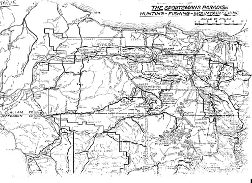
Fri Feb 05, 2010 12:35 am Taplin's Olympic Trails Guide
|
|
|
|
| Back to top |
|
|
|
|
You cannot post new topics in this forum
You cannot reply to topics in this forum
You cannot edit your posts in this forum
You cannot delete your posts in this forum
You cannot vote in polls in this forum
|
Disclosure: As an Amazon Associate NWHikers.net earns from qualifying purchases when you use our link(s). |


