| Previous :: Next Topic |
| Author |
Message |
cartman
Member


Joined: 20 Feb 2007
Posts: 2800 | TRs | Pics
Location: Fremont |
|
cartman
Member
|
 Wed May 19, 2010 10:35 pm |
|
|
This is the 7157' high point of the ridge 5 miles east of the East Creek TH and one mile west of Methow Pinnacles on the north side of Highway 20. I'd been suggesting this one nearly every week for about a month as a good spring day trip, based on a TOPO map of the area, probable safe ridge run and the likelihood of great views. Matt found some pics from a trip up Gabriel etc. several years ago in June, which showed the terrain going up to this peak that made it look like a good choice for the dangerous avy conditions forecasted, so we decided to finally make this one happen. Joining us were gregor, Dave C., Martin and Mike C.
We parked at the pullout just E of where Hwy 20 crosses Granite Creek. We decided to do the most direct of the three prospective routes since the map and pics made it look like a safe treed ridge run until close to the main E-W trending ridge. This is a trail-less route trending a little left but mostly up the hillside. Easy but sustained up on this route. One spot where we had to thread through a minor cliff band up a short, loose gully. Views south kept getting better as we gained elevation and the trees got more open. We didn't hit snow until far up the slope; snow was firm and we never used snowshoes.
About 250' below the main ridge, two choices presented themselves. Continue up the ridge (more like a steeper, sparsely treed slope here) or traverse left 200-300', part of the way below an open slope to another ridge that looked better. I dug a pit here to check on the snow conditions, and found 5 feet of good consolidated snow, no weak layers. This face gets a lot of direct sun in the afternoon and must pack down more quickly than many others. I felt OK about traversing this based on the conditions observed from the pit, the firm footing up to there, the temps were not particularly warm yet, no cliffs or gorges below, and especially that the slope and surrounding slopes at that aspect (south) showed zero effects of warming--no snowballing or sliding. We all had beacons and avy gear. Once on the ridge we did observe point release snowballing on the east aspects which had received sun sooner.
Booting over to this neighboring ridge then up to the main ridge on good snow, we continued to the summit with spectacular views in all directions. The summit even had bare rocks for hanging out. Plenty of pointing out of peaks--it's kind of amazing that despite all of the cumulative experience, we are still sometimes unsure which peak is which.
We were all up for a traverse, so we headed north along the ridge with the goal of gaining the East Creek Trail at ~3600' and walking that out. Snow had softened considerably by this time so not reversing our route may have been a wise choice. As we continued to drop along the ridge, the post-holing became more troublesome so we tended to walk on the left out of the snow. Considerable blowdown on the ridge and slope; however, the trees are generally not very large so it's easy to step over or around them. But there are a lot of them.
The ridge is rather broad in places, but when occasionally wandering too far left or right one can simply correct by contouring uphill until cresting the top, and then continuing back down. Gets a bit steep at ~4000', but easy to find a route through or around to the left. Connected to trail exactly where expected, which was in good shape, some blowdowns to negotiate but otherwise fine.
Another good day in the hills.
~9 miles, 4000' gain.
Eric Johnson
|
| Back to top |
  
|
|
Matt
Tea, Earl Grey, Hot

Joined: 30 Jan 2007
Posts: 4307 | TRs | Pics
Location: Shoreline |
|
Matt
Tea, Earl Grey, Hot
|
Thu May 20, 2010 12:26 am Point 7157 Traverse (USGS Azurite), 5/15/10
|
|
|
Date: 5/15/10
Destination: Point 7157 (USGS Azurite)
Party: cartman, gregor, Martin Shetter, Mike Collins, Dave Creeden, Matt
Point 7157 lies midway on a ridge that rises from the East Creek trailhead on its northwest end to Methow Pinnacles on its southeast end.
Because the ridge parallels East Creek, Im naming it East Creek Ridge for convenience.
Three possible routes lead to Point 7157.
- Granite Creek Direct Route: From the bridge where SR20 crosses Granite Creek, ascend a slope & ridge ENE to the unmarked point just south of Point 7157 (which Ill call Point 7140 for convenience) and then follow the ridge briefly north to Point 7157. This route is less scenic, but most direct, and stays mostly on a crest that seemed likely to avoid avalanche terrain. 2.3 miles, 3800 gain. Yellow line on map.
- East Creek Ridge Route: From the East Creek trailhead, take the trail to 3600 feet, then follow the crest of East Creek Ridge southeast over Point 6844 to Point 7157. This route is longest but lowest angle. However, it has multudinous small trees to hop over. 5 miles, 4600 gain. Red line on map.
- Methow Pinnacles Route: From milepost 150, follow a rib ENE toward Methow Pinnacles. Circa 6600 feet, turn northwest, drop to a 6400-foot col, then follow the ridge over Ponit 7073 to Point 7157. This route is very scenic, but has somewhat open slopes near the turn. 4 miles, 4000 gain. Purple line on map.
We ascended via the Granite Creek Direct Route and descended via the East Creek Ridge Route. In more consolidated conditions, doing the compete run up the Methow Pinnacles Route and down the East Creek Ridge Route would be especially scenic.
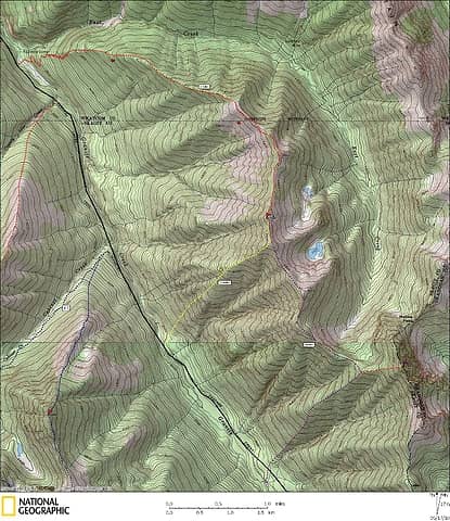 Point 7157 Route map (Ignore the lines west of the highway from other trips.) 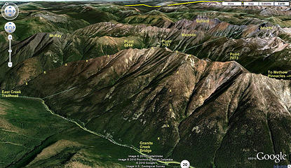 Point 7157 Route viewed from high perspective in Google Maps Earth View 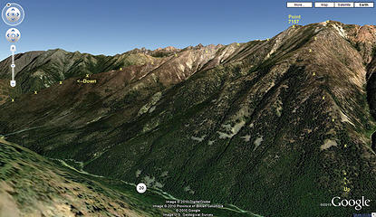 Point 7157 Route viewed from low perspective in Google Maps Earth View 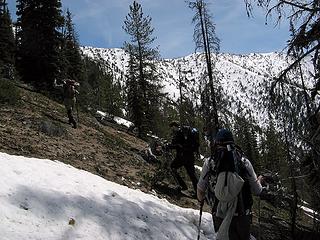 Going up mostly dry ground with a few patches of snow 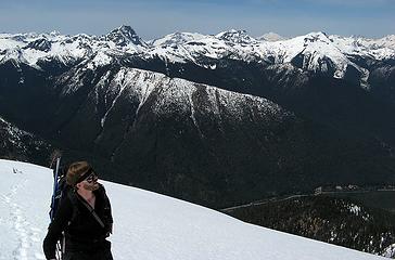 Arriving on 7140, with view west to County Line Ridge & Gabriel 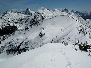 6 labels Looking SE to Point 7073 & Methow Pinnacles, with Mebbe Pass on left  Mebbe Pass, Holliway & Golden Horn 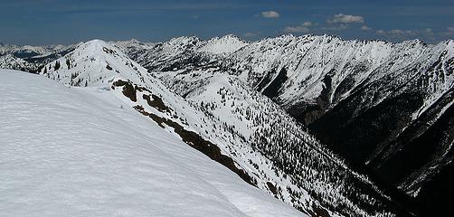 View north up East Creek Ridge & East Creek 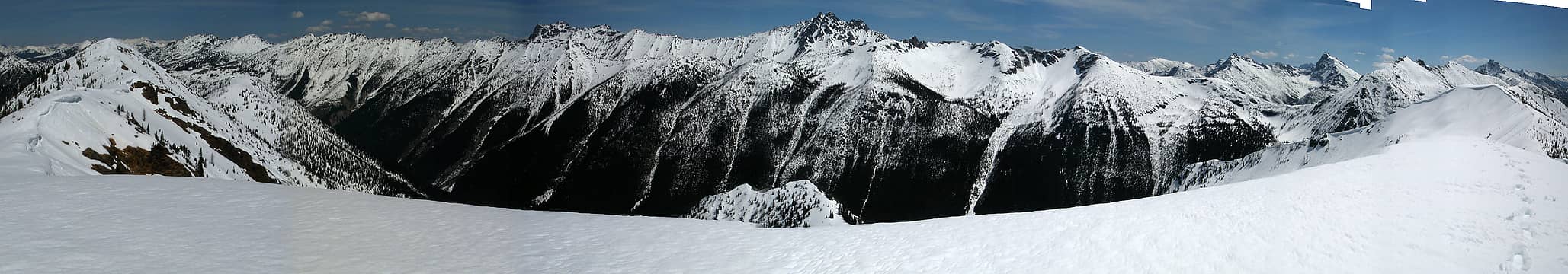 2 labels 180-degree panorama looking east from Point 7140. 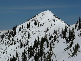 Martin & Dave on 7157 summit 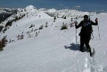 Running the crest from 7140 to 7157 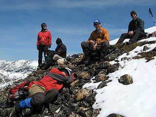 Comfy rocks for a summit break & nap 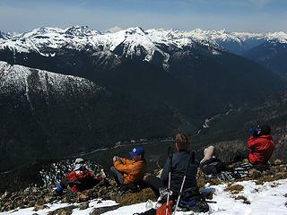 Enjoying the view northwest 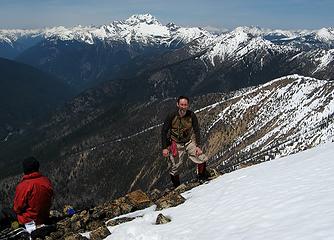 4 labels Looking north to our descent ridge & to Jack & McKay 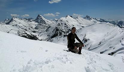 View south to Mebbe Pass peaks, Methow Pinnacle & Point 7073 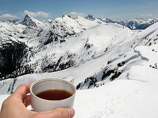 Summit tea 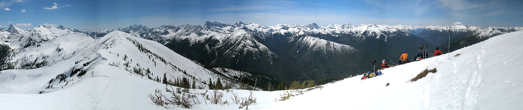 180 degree pan from SE to SW to NW 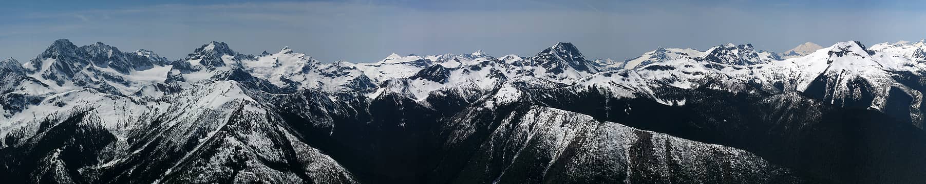 13 labels 90 degree pan looking west: Ragged Ridge, Icecap Traverse. & Gabriel/Elija group 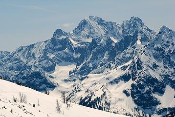 4 labels Black Peak, with Repulse, Fisher, & Graybeard at front right 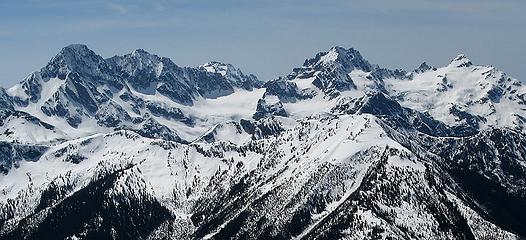 Ragged Ridge (& Logan) 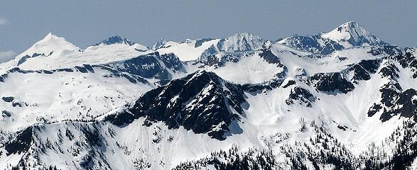 1 label Icecap Traverse (Eldorado, Klawatti, Austera, Tricouni, Primus) 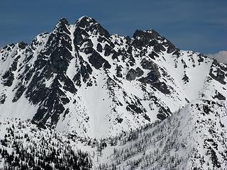 Azurite, showing the snow-filled central gully 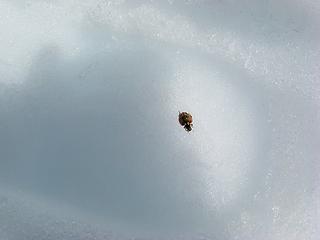 First ladybug sighting of the year, sitting in a footprint on the snow 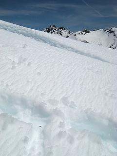 The ladybug in context, with Azurite behind 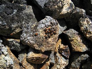 Ladybugs on overturned summit rock 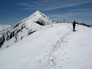 Descending from Point 7157 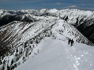 Heading from Point 7157 to Point 6844 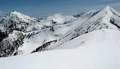 3 labels Looking back from Pont 6844 to Point 7157, Point 7073, & Methow Pinnacles. 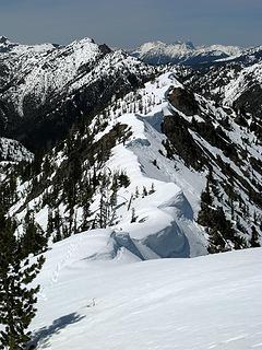 Somewhat corniced crest beyond Point 6844 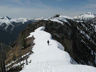 Crossing the knuckle 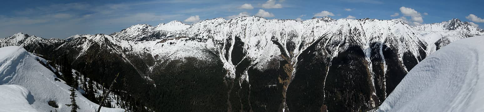 3 labels 150-degree pan of the long crest of McKay & Magestic 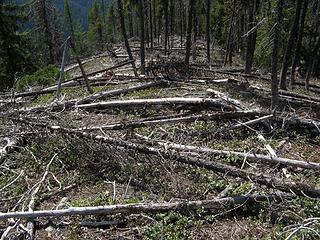 Hurdles on the descent ridge 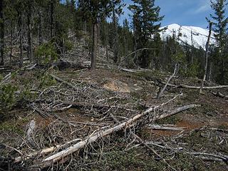 Looking back toward the snowy high points 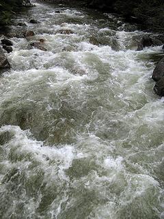 Granite Creek 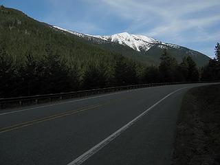 SR20 view back to our ascent ridge while trying to hitchhike back to the cars
As beacons mountains burned at evening. J.R.R. Tolkien
 Now I Fly Now I Fly
As beacons mountains burned at evening. J.R.R. Tolkien
Now I Fly
|
| Back to top |
|
|
wamtngal
Member

Joined: 13 Jun 2004
Posts: 2382 | TRs | Pics
Location: somewhere |
|
wamtngal
Member
|
Thu May 20, 2010 9:05 am |
|
|
Matt -- I'm enjoying your animated photos. Both this TR and the last one. Keep doing them. 
Opinions expressed here are my own.
Opinions expressed here are my own.
|
| Back to top |
|
|
iron
Member

Joined: 10 Aug 2008
Posts: 6392 | TRs | Pics
Location: southeast kootenays |
|
iron
Member
|
Thu May 20, 2010 9:13 am Re: Point 7157 Traverse (USGS Azurite), 5/15/10
|
|
|
| Matt wrote: | | The key was not to stick out a thumb for hitchhiking, but rather desperately wave your arms and look pathetic, so that someone will stop long enough to learn that we only need a ride for 4 miles. |
excellent advice 
|
| Back to top |
|
|
RichP
Member

Joined: 13 Jul 2006
Posts: 5634 | TRs | Pics
Location: here |
|
RichP
Member
|
Thu May 20, 2010 10:17 am |
|
|
I love a good ridge walk like this one. I'll definitely keep this in my memory bank for the future. Thanks 
|
| Back to top |
|
|
loper
Member
Joined: 11 Aug 2007
Posts: 453 | TRs | Pics
Location: seeking the sun |
|
loper
Member
|
Fri May 21, 2010 8:36 pm |
|
|
Another good day in the mountains brought to us by Matt and Cartman.
Thanks for the TR.
Wish I could have swung joining you guys. (Only two more LOR FT till I am free, free I say, freeeeeee!)
Lisa
|
| Back to top |
|
|
|
|
You cannot post new topics in this forum
You cannot reply to topics in this forum
You cannot edit your posts in this forum
You cannot delete your posts in this forum
You cannot vote in polls in this forum
|
Disclosure: As an Amazon Associate NWHikers.net earns from qualifying purchases when you use our link(s). |


