| Previous :: Next Topic |
| Author |
Message |
cartman
Member


Joined: 20 Feb 2007
Posts: 2800 | TRs | Pics
Location: Fremont |
|
cartman
Member
|
 Mon Jul 19, 2010 9:59 pm |
|
|
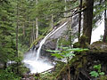
OK, you've all seen 'em, so I won't bore you with more pics of this beautiful area--not that I was going to anyway.  This was going to be a climb of Adams via the Mazama Glacier, but as the road to that TH is still gated, I switched to Snowking, which neither I, ejain, or Dorothy had ever done.
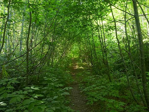
I had read reports that the approach trail was brutally steep, "relentless", very brushy etc etc. I found none of these to be true. Heck, the road walk has more brush than the entire trail has. Only the first 300' of the actual trail is brushy, and that no big deal. The trail is at its steepest here, but past that isn't any worse than numerous others I've been on, and has plenty of opportunities to relax. TH starts at 1250', trail at 2300', then lays back a bit at 4000' at its closest point to Found Creek. Continues up to a flat marshy area at ~4800', up to 5000' then traverses down and right to the 4800' saddle in the woods. Never did see the side trail to Found Lake. Right where the trail goes up from the saddle is the only place you might lose it as it starts to rise to Peak 5791, Found Peak--not the highest point on Kindy Ridge but the only point that has prominence.
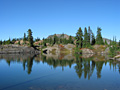
Around 5200' is where we encountered the first significant snow. Soon after we'd see the trail in and out of the snow; best bet is to follow the path of least resistance on or near the ridge crest. Took a good break at the top of Found Pk, then continued down a bit of scrambly trail to the 5250' saddle. Up and over the next two bumps, then dropped down toward the two small lakelets just N of Cyclone Lake. Though this was mostly still snowed in, we found an excellent spot near the smallest lakelet perfect for a small 2-man tent and my spankin' new Tarptent Rainbow with stellar views of Snowking.
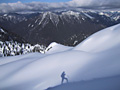
Concerns about the low marine layer were dispatched when we woke to crystal clear skies at 6am. Headed up the usual route w/crampons over Peak 5860 (the end of and the highest point on Kindy Ridge) and down to the beginning of Snowking's NE Ridge. Soon we found the track of the couple who were the only others in the area this weekend. The marine layer began to rise with the temps, but though many of the surrounding peaks were shrouded in mist, Snowking seemed to reside in an isle of sunshine the entire day.
Most of the ridge was still snow covered, but conditions were good and we made it to and over the summit ridge and headed up on rather mediocre class 3 rock the 200' to the summit. Extensive searching turned up no summit register. Think this was one of Eric's (ejain) first big peaks and he did great.
To put the question of elevation gain on this route to rest, I kept track via map and altimeter and came up with about 9000' cumulative gain. That's equal to the DC route on Rainier for total gain. 6200' car to summit, 1000' lost and regained each way to/from camp, and 650' lost/regained RT camp to summit. And 150' marching around to find a dry camp...now if I only had a decent grasp of the mileage, since that's all over the place in guide books and TRs too. Though I can say that the road walk is closer to 2.5 miles than two because of how long it took to hike it.
Eric J. Johnson
This was going to be a climb of Adams via the Mazama Glacier, but as the road to that TH is still gated, I switched to Snowking, which neither I, ejain, or Dorothy had ever done.
I had read reports that the approach trail was brutally steep, "relentless", very brushy etc etc. I found none of these to be true. Heck, the road walk has more brush than the entire trail has. Only the first 300' of the actual trail is brushy, and that no big deal. The trail is at its steepest here, but past that isn't any worse than numerous others I've been on, and has plenty of opportunities to relax. TH starts at 1250', trail at 2300', then lays back a bit at 4000' at its closest point to Found Creek. Continues up to a flat marshy area at ~4800', up to 5000' then traverses down and right to the 4800' saddle in the woods. Never did see the side trail to Found Lake. Right where the trail goes up from the saddle is the only place you might lose it as it starts to rise to Peak 5791, Found Peak--not the highest point on Kindy Ridge but the only point that has prominence.
Around 5200' is where we encountered the first significant snow. Soon after we'd see the trail in and out of the snow; best bet is to follow the path of least resistance on or near the ridge crest. Took a good break at the top of Found Pk, then continued down a bit of scrambly trail to the 5250' saddle. Up and over the next two bumps, then dropped down toward the two small lakelets just N of Cyclone Lake. Though this was mostly still snowed in, we found an excellent spot near the smallest lakelet perfect for a small 2-man tent and my spankin' new Tarptent Rainbow with stellar views of Snowking.
Concerns about the low marine layer were dispatched when we woke to crystal clear skies at 6am. Headed up the usual route w/crampons over Peak 5860 (the end of and the highest point on Kindy Ridge) and down to the beginning of Snowking's NE Ridge. Soon we found the track of the couple who were the only others in the area this weekend. The marine layer began to rise with the temps, but though many of the surrounding peaks were shrouded in mist, Snowking seemed to reside in an isle of sunshine the entire day.
Most of the ridge was still snow covered, but conditions were good and we made it to and over the summit ridge and headed up on rather mediocre class 3 rock the 200' to the summit. Extensive searching turned up no summit register. Think this was one of Eric's (ejain) first big peaks and he did great.
To put the question of elevation gain on this route to rest, I kept track via map and altimeter and came up with about 9000' cumulative gain. That's equal to the DC route on Rainier for total gain. 6200' car to summit, 1000' lost and regained each way to/from camp, and 650' lost/regained RT camp to summit. And 150' marching around to find a dry camp...now if I only had a decent grasp of the mileage, since that's all over the place in guide books and TRs too. Though I can say that the road walk is closer to 2.5 miles than two because of how long it took to hike it.
Eric J. Johnson
|
| Back to top |
  
|
|
ejain
Member

Joined: 27 Apr 2009
Posts: 1498 | TRs | Pics
Location: Seattle, WA |
|
ejain
Member
|
Mon Jul 19, 2010 10:27 pm |
|
|
 FR-1570 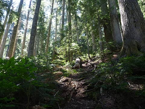 Approach Trail 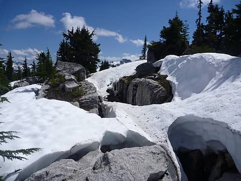 Trail Somewhere 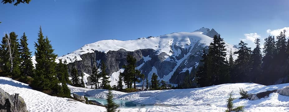 View from Camp 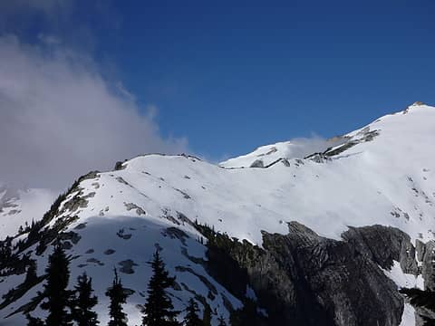 Ridge 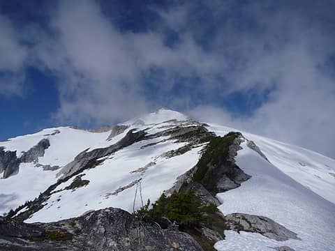 On the Ridge 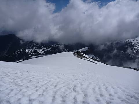 Snow Field 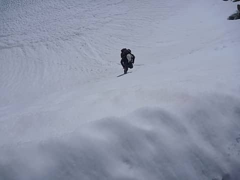 Snow Wall 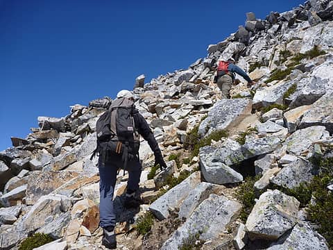 Summit Scramble 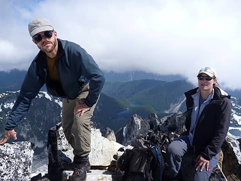 Cartman & Dorothy on Summit 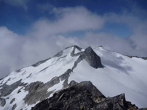 Neighbor 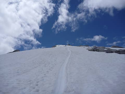 Glissade
|
| Back to top |
|
|
Magellan
Brutally Handsome

Joined: 26 Jul 2006
Posts: 13116 | TRs | Pics
Location: Inexorable descent |
|
Magellan
Brutally Handsome
|
Mon Jul 19, 2010 10:32 pm |
|
|
|
| Back to top |
|
|
ejain
Member
Joined: 27 Apr 2009
Posts: 1498 | TRs | Pics
Location: Seattle, WA |
|
ejain
Member
|
Mon Jul 19, 2010 10:50 pm |
|
|
Google Earth thinks the tracklog shows close to 7,800 ft cumulative gain and 1,500 ft loss over 8.5 miles from car to summit (also excluding the detour to the campsite)...
|
| Back to top |
|
|
joker
seeker

Joined: 12 Aug 2006
Posts: 7953 | TRs | Pics
Location: state of confusion |
|
joker
seeker
|
Mon Jul 19, 2010 10:50 pm |
|
|
Nice one! I have to agree on the trail - it is steep-ish and more New Englandy than a named/numbered Cascades trail, but it was not severe. A tad muddy in June when there was solid snow above 4K (all the better for our ski trip), but that's mostly what I recall about it.
9K? My Suunto watch racked up a cumulative 7500 of gain from car-to-summit-and-back on our day trip back in '99, but I'm always skeptical of both watch-logged and GPS logged stats (I've been hearing some intriguing GPS-logged distance claims this summer). There was a little less road to walk (we parked right before a washout - I seem to recall that there's a newer obstacle before that now), but not that much less elevation. My body may agree with your estimate, though, as I recall being a tad trashed the day after. One of these summers I have to get up there to camp in the alpine for a night or two.
|
| Back to top |
|
|
ejain
Member
Joined: 27 Apr 2009
Posts: 1498 | TRs | Pics
Location: Seattle, WA |
|
ejain
Member
|
Mon Jul 19, 2010 10:53 pm |
|
|
|
| Back to top |
|
|
Tom
Admin
Joined: 15 Dec 2001
Posts: 17851 | TRs | Pics
|
|
Tom
Admin
|
Mon Jul 19, 2010 11:13 pm |
|
|
As far as gain, the math isn't hard. The summit is 7433' and the current trailhead is ~1120', or a minimum gain of ~6300'. Since you hit all the bumps, add 500' for the loss from 5791', 200' for the loss from 5695', and 300' for the loss from 5860', leading to a gain of ~7300'.
|
| Back to top |
|
|
ejain
Member
Joined: 27 Apr 2009
Posts: 1498 | TRs | Pics
Location: Seattle, WA |
|
ejain
Member
|
Mon Jul 19, 2010 11:29 pm |
|
|
| Tom wrote: | | As far as gain, the math isn't hard. The summit is 7433' and the current trailhead is ~1120', or a minimum gain of ~6300'. Since you hit all the bumps, add 500' for the loss from 5791', 200' for the loss from 5695', and 300' for the loss from 5860', leading to a gain of ~7300'. |
That doesn't include the elevation gain on the way out: 7,300 + 500 + 200 + 300 = 8,300
|
| Back to top |
|
|
Tom
Admin
Joined: 15 Dec 2001
Posts: 17851 | TRs | Pics
|
|
Tom
Admin
|
Mon Jul 19, 2010 11:41 pm |
|
|
Good point, not to mention uphill both ways in the snow. 
|
| Back to top |
|
|
silence
Member

Joined: 25 Apr 2005
Posts: 4420 | TRs | Pics
|
|
silence
Member
|
Tue Jul 20, 2010 6:04 am |
|
|
it sucks when it's wet 
Approach Trail
PHOTOS
FILMS
Keep a good head and always carry a light bulb. Bob Dylan
PHOTOS
FILMS
Keep a good head and always carry a light bulb. Bob Dylan
|
| Back to top |
|
|
cartman
Member
Joined: 20 Feb 2007
Posts: 2800 | TRs | Pics
Location: Fremont |
|
cartman
Member
|
Tue Jul 20, 2010 6:44 am |
|
|
TH TO SUMMIT:
TH 1250' to summit 7433' = 6200' gain
APPROACH/OUT:
5000' to 4800' saddle = 400' RT regained
Peak 5791' to 5250' saddle = 1100' RT regained
Point 5695' to 5600' saddle = 200' RT regained
Saddle b/n lakelets to camp = 75' regained coming in
5500' Saddle b/n lakelets to Point 5695' = 200' gain going out
SUMMIT:
Saddle b/n lakelets to camp = 150' regained
Peak 5860' to Snowking ridge low point = 500' RT regained
Snowking ridge = 100' RT regained
Plus area wanderings...
TOTAL = ~9000' gain
|
| Back to top |
|
|
Layback
Cascades Expatriate

Joined: 16 Mar 2007
Posts: 5712 | TRs | Pics
Location: Back East |
|
Layback
Cascades Expatriate
|
Tue Jul 20, 2010 8:47 am |
|
|
Nice job Eric. I had no idea you were up there this weekend. I was looking at Snowking from camp on Sahale thinking if I wasn't in such a fine place, I wouldn't mind being over there.
|
| Back to top |
|
|
silence
Member
Joined: 25 Apr 2005
Posts: 4420 | TRs | Pics
|
|
silence
Member
|
Tue Jul 20, 2010 9:09 am |
|
|
hmmm .. we got a total RT 19.25 mi, gain 10,000'+ .. but we were up there for 3 nites and did a lot of wandering for photos .. everyone's trips this year .. starting with irons .. has made me want to go back with a little more snow on the mountain ...
PHOTOS
FILMS
Keep a good head and always carry a light bulb. Bob Dylan
PHOTOS
FILMS
Keep a good head and always carry a light bulb. Bob Dylan
|
| Back to top |
|
|
Tom
Admin
Joined: 15 Dec 2001
Posts: 17851 | TRs | Pics
|
|
Tom
Admin
|
Tue Jul 20, 2010 10:39 am |
|
|
Cartman, I think you're counting too much gain. For example, 5000' to 4800' saddle - I don't recall the route going up to 5000'. Sounds like you got off route which accounts for some of the difference in math.
|
| Back to top |
|
|
Josh Cowart
hiker/fisherman

Joined: 26 Sep 2007
Posts: 169 | TRs | Pics
Location: crawling in 6' brush |
Uggggghh Thats two snowking reports now and no pictures of the found lakes! You guys are not making me happy. How can you walk past those and not take and post pictures!? I guess I truly am a lake bagger.
Nice trip report and pictures though. 
|
| Back to top |
|
|
|
|


