| Previous :: Next Topic |
| Author |
Message |
Tom_Sjolseth
Born Yesterday


Joined: 30 May 2007
Posts: 2652 | TRs | Pics
Location: Right here. |
Birddog and I linked up for a great traverse of the Dakobed Range this past weekend. The original plan was to climb Tenpeak and W Tenpeak from White River via Thunder Basin, but a sudden change of heart (mid-approach) led to us embarking on a rugged, scenic, and unique traverse.
Day 1
From White River TH, it is ~7 miles to the turn off to Thunder Basin, the now standard approach to the Tenpeak massif. As we ascended the trail, the insects soon became oppressive. Just after Boulder Pass Trail, the White River Trail got very brushy. From that point on, we couldnt see our feet, and could only barely make out the faint outline of a trail. After about 10 minutes of this, as I looked at the relatively brush-free cliffs just adjacent to us, I remembered a trip Paul Klenke and I shared where we climbed Clark and Luahna in a day via a watercourse draining Clarks SE slopes - it was a very direct and trouble-free route, a from-scratch route that Paul Klenke is quite good at coming up with. I asked Geoff if he was interested in this route, and he said, sure. So it was settled, we were now doing a traverse.
Since we didnt leave the trailhead until about 4:30PM, we decided to camp on flat slabs just adjacent to the watercourse. We had a great sleep among clear skies.
Day 2
The next morning we awoke and began climbing up the watercourse, crossing three times to avoid brush and cliffs. After about 1000, the slabs and brush turn into very pleasant heather and abundant wildflowers. The wildflowers are in full bloom right now, and in combination with all the snow up high and the greenery and the cascading waterfalls, it was a sight!
After about 4000 of climbing, we finally topped out on a ridge overlooking Boulder Pass. We followed the ridge about 1 mile on or near its crest until we got to the slopes below Clark Mtn. The scramble of Clark on its S side is class 3. The summit register is a big white Mountaineers PVC tube placed by NWHikers own Modern.
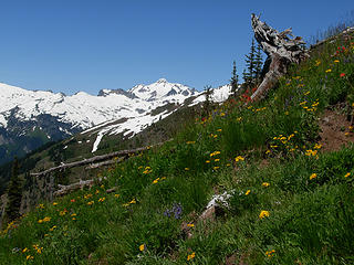
As it was getting later in the day, we descended Clark in search of a campsite. We found a dry one with running water at 7700 in the basin between Clark and Pt 7970. That evening, we headed up to the summit of Pt 7970 to get a view of the sunset. Im glad we did, because we were treated to one of the neatest sunsets Ive ever witnessed. Glacier Peak, Kololo, and the entire Tenpeak Massif were the dominant features. Splendid.
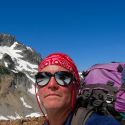
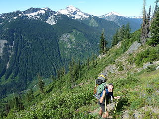 Geoff ascending steep slopes below Clark Mtn. 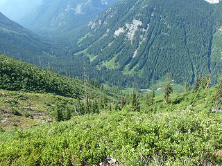 Looking down to White River. 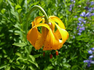 Tiger Lily. 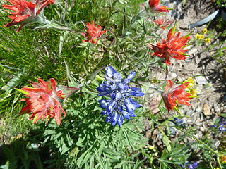 Lupine and Indian Paintbrush. 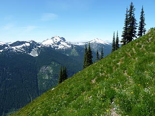 The view towards Saul and Indian Head. 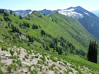 Typical terrain on the approach to Clark Mtn. 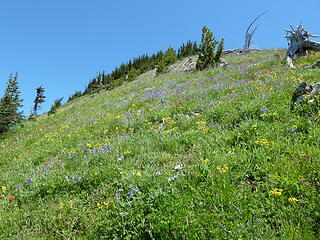 Wildflowers! 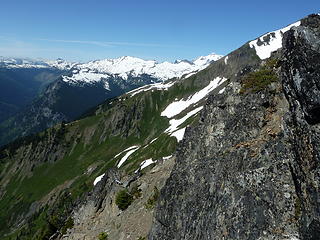 Kololo, Tenpeak, and Glacier Peak. 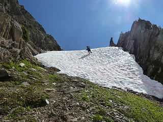 Geoff descending steep snow below Clark Mtn. 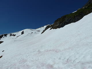 The slopes we traverse. 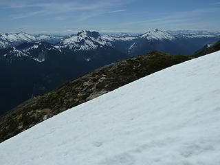 Mt. Saul and Indian Head. 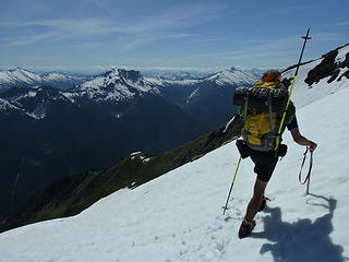 Geoff traversing. The antenna strapped to his backpack is actually connected to a tiny personal locator beacon implanted in his lower back.. 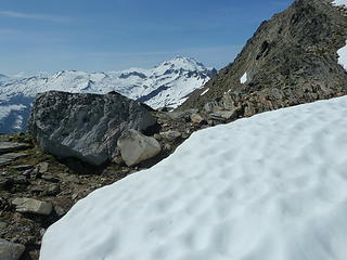 Views to Glacier Peak. 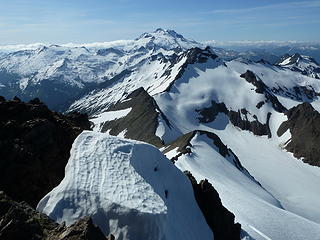 The Tenpeak massif and Glacier Peak. 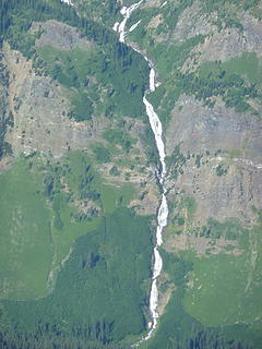 Louis Creek. That's a lot of water! 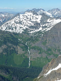 Buck Mountain and Louis Creek Basin. Entiat Range beyond. 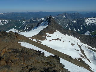 A pinnacle above Boulder Pass. 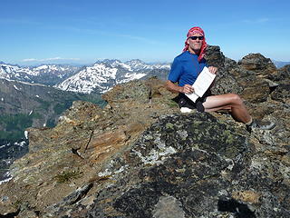 Geoff on the summit of Clark Mountain. 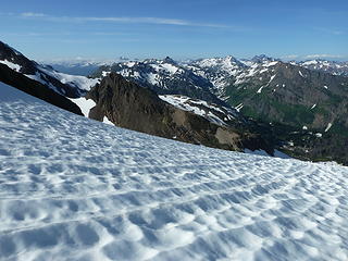 Looking towards High and Buck Creek Passes. 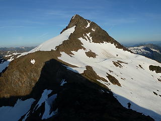 Clark Mountain. The gully we used to descend can be seen at upper right. 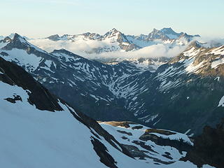 Looking N to Fortress and Bonanza. 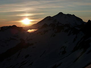 Sunset on Glacier Peak. 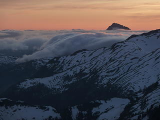 Beautiful colors over Sloan Peak. 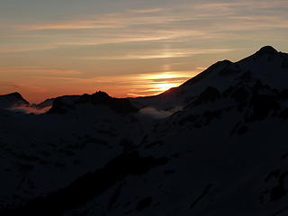 Glacier Peak at Sunset. 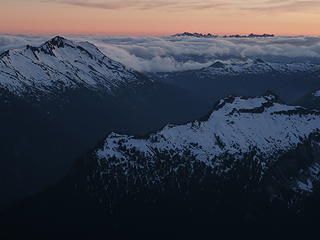 Sunset over the Monte Cristo Range. 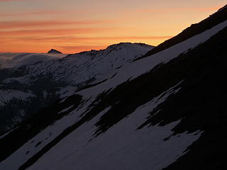 Sloan Peak peeking above the lucid cloud deck, bathed in reds and ambers. 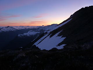 The last rays of light. 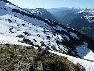 A thin layer of fog (or mosquitoes?) in the valley. 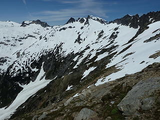 The Tenpeak massif. 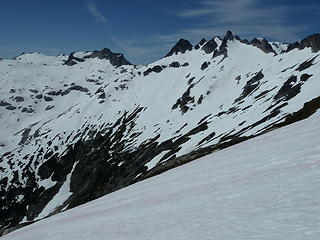 Tenpeak. 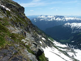 Geoff traversing ledges and wet heather. 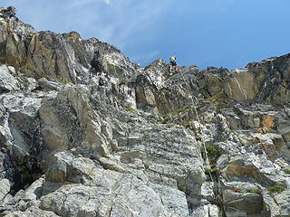 Rappelling into Upper Thunder Basin. 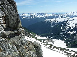 Looking down into Thunder Basin. 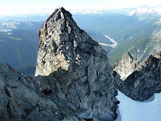 Geoff climbing up Tenpeak. Suiattle River headwaters below. 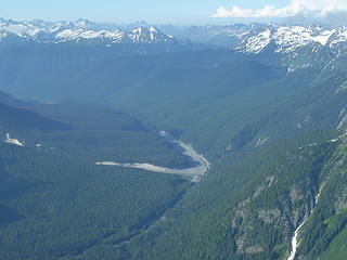 Upper Suiattle River. 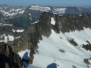 Part of the Tenpeak massif with Buck Mountain beyond. 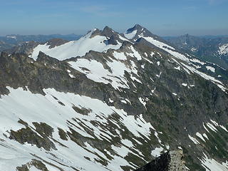 Luahna and Clark. 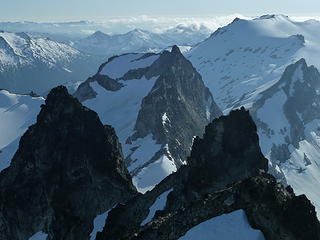 W Tenpeak and Kololo from the summit of Tenpeak. 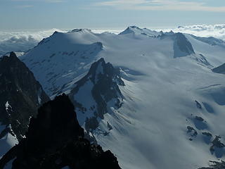 Kololo and the Honeycomb Glacier. 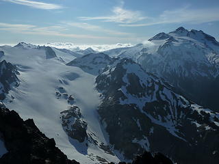 Kololo, Honeycomb, and Glacier Peak. 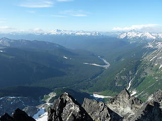 Can't get enough of the Suiattle River. What a unique view! 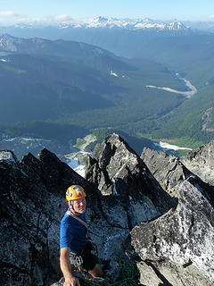 Geoff on the summit of Tenpeak. 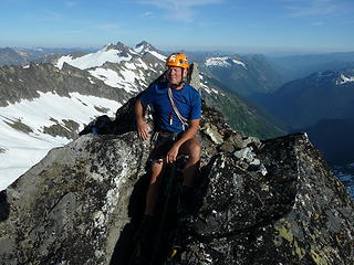 Geoff enjoying a little sleepy time on the summit of Tenpeak. 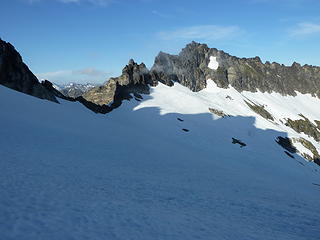 Swirling mist dances around one of the Tenpeaks. 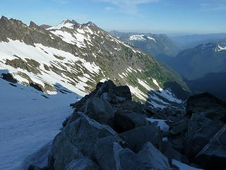 Looking back at our traverse.  It took about an hour to gain the col just S of W Tenpeak, where I chased a family of goats up and out of sight. I stashed my overnight gear, and headed up with a rope, some slings, and some cams (just in case). The scrambling on lower W Tenpeak was very enjoyable, high alpine ridge climbing, with great views on both sides. Just as I got to where the ridge flattens out, the family of goats that I chased down low were now scurrying across seemingly impossible cliff bands to get away from me. They were pulling moves that rock jocks would envy!
Near the summit, the climbing gets wildly exposed, but the climbing is fairly easy (low fifth). The rock was coated with flaky lichen, so I was very careful to concentrate 100% on every move, and not worry about the exposure (which, admittedly, was getting to me a little bit being unroped and with so much lichen to make things feel insecure). Just below the summit, I placed a cam in a crack and clipped my personal to it and made the move above the cam with security and confidence.
The summit is a tiny perch with a stack of rocks for a summit cairn. There was a Fay Pullen register up there that was placed a few weeks ago when she, Matt, and Mtn Mike climbed it, and an old, rusty, empty tube. I added my name to the register and made my way back down, rappelling twice on the N Face.
The trip back down Thunder Basin was entertaining, and much trail-finding shenanigans ensued. The climbers paths into these basins are works of art, but take much concentration to keep on them. If these trails werent here, getting into the basin would be an epic bushwhack. Despite there being a "trail" here, don't expect brush-free travel.
The mosquitoes on the way back to the TH were the absolute WORST IVE EVER SEEN!! 100s of mosquitoes orbited and dive bombed me all the way back to the car. I wound up hiking in a head net and schoeller jacket (hot!!) just to avoid the little buggers. Bring Deet.
One of the finest areas in the range.
Trip Stats:
-14,000' gain
-25 miles
It took about an hour to gain the col just S of W Tenpeak, where I chased a family of goats up and out of sight. I stashed my overnight gear, and headed up with a rope, some slings, and some cams (just in case). The scrambling on lower W Tenpeak was very enjoyable, high alpine ridge climbing, with great views on both sides. Just as I got to where the ridge flattens out, the family of goats that I chased down low were now scurrying across seemingly impossible cliff bands to get away from me. They were pulling moves that rock jocks would envy!
Near the summit, the climbing gets wildly exposed, but the climbing is fairly easy (low fifth). The rock was coated with flaky lichen, so I was very careful to concentrate 100% on every move, and not worry about the exposure (which, admittedly, was getting to me a little bit being unroped and with so much lichen to make things feel insecure). Just below the summit, I placed a cam in a crack and clipped my personal to it and made the move above the cam with security and confidence.
The summit is a tiny perch with a stack of rocks for a summit cairn. There was a Fay Pullen register up there that was placed a few weeks ago when she, Matt, and Mtn Mike climbed it, and an old, rusty, empty tube. I added my name to the register and made my way back down, rappelling twice on the N Face.
The trip back down Thunder Basin was entertaining, and much trail-finding shenanigans ensued. The climbers paths into these basins are works of art, but take much concentration to keep on them. If these trails werent here, getting into the basin would be an epic bushwhack. Despite there being a "trail" here, don't expect brush-free travel.
The mosquitoes on the way back to the TH were the absolute WORST IVE EVER SEEN!! 100s of mosquitoes orbited and dive bombed me all the way back to the car. I wound up hiking in a head net and schoeller jacket (hot!!) just to avoid the little buggers. Bring Deet.
One of the finest areas in the range.
Trip Stats:
-14,000' gain
-25 miles
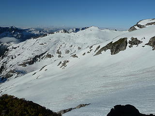 Morning views from camp below Tenpeak. 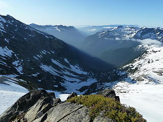 The White River Valley begins to heat up. 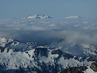 Daniel and Hinman rise above the cloud deck. 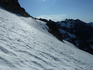 Looking back towards camp from my traverse to W Tenpeak. 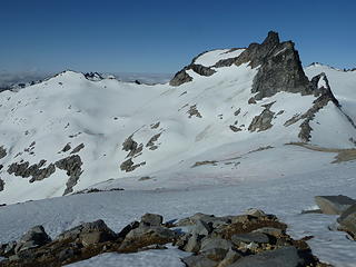 W Tenpeak. 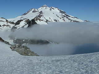 Glacier Peak as seen from the col between W Tenpeak and Tenpeak. This is one of the most amazing spots I've ever been to. 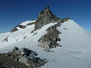 W Tenpeak threatens. 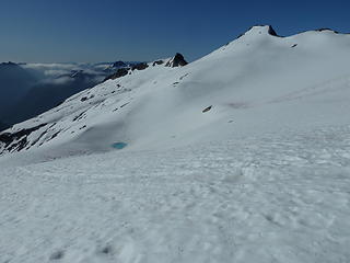 A little tarn on the way up to W Tenpeak. 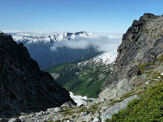 Looking SW from the notch in W Tenpeak's S Ridge. 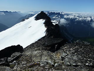 Enjoyable high ridge scrambling. 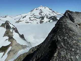 "Yes" Peak. 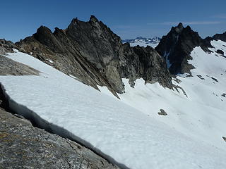 Looking up to the summit of W Tenpeak from the S Ridge. 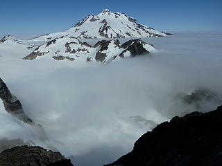 Glacier Peak sits watch above the clouds. 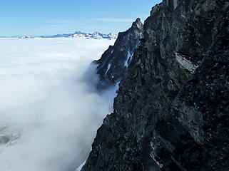 Stunning views just below the summit of W Tenpeak. 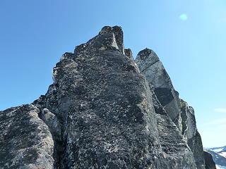 The climbing route above me. 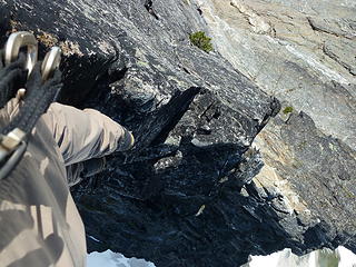 Lots of exposure here. 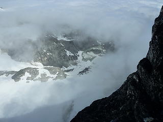 Peering through the cloud deck at a lake-tarn at the toe of the Honeycomb Glacier. 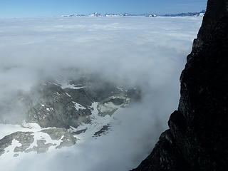 "" "". 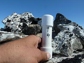 I've seen a few of these around. 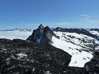 Tenpeak from the summit of W Tenpeak. 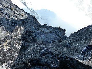 Looking down from the summit of W Tenpeak. 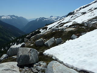 Upper Thunder Basin. 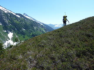 Geoff enjoying some high alpine roaming on the descent into Lower Thunder Basin. 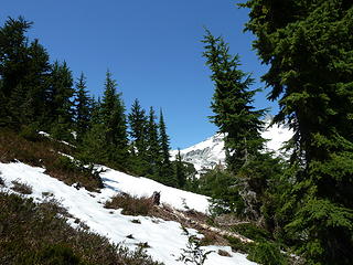 The views on the descent. 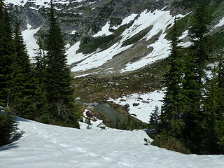 Thunder Creek. 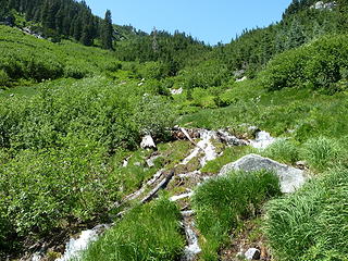 Brushy. The trail certainly helps.. if you can find it! 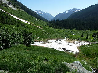 Meadows in Lower Thunder Basin. 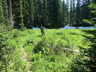 Geoff headed for home.
|
| Back to top |
  
|
|
silence
Member

Joined: 25 Apr 2005
Posts: 4420 | TRs | Pics
|
|
silence
Member
|
 Wed Aug 10, 2011 10:55 am |
|
|
sweeet trip tom .. and as always a great tr and pix ... way to go!!!
kyle had a run in with those goats when he and jace were there in 09 .. rascals  btw is there some place where we can read about fay's ongoing climbs to place the summit registers? her name keeps popping up every where now .. in the olys and cascades
PHOTOS
FILMS
Keep a good head and always carry a light bulb. Bob Dylan
PHOTOS
FILMS
Keep a good head and always carry a light bulb. Bob Dylan
|
| Back to top |
|
|
Stefan
Member

Joined: 17 Dec 2001
Posts: 5091 | TRs | Pics
|
|
Stefan
Member
|
Wed Aug 10, 2011 12:22 pm |
|
|
great stuff Tom. the traversing in the wildflowers and heather looks awesome! me jealous? You bet!
|
| Back to top |
|
|
iron
Member

Joined: 10 Aug 2008
Posts: 6392 | TRs | Pics
Location: southeast kootenays |
|
iron
Member
|
Wed Aug 10, 2011 1:21 pm |
|
|
cool views of the suiattle headwaters. such an amazing river!
looks like a lot of lichen on the summit.
any camp spots near that tarn that's not yet melted out?
|
| Back to top |
|
|
Tom_Sjolseth
Born Yesterday
Joined: 30 May 2007
Posts: 2652 | TRs | Pics
Location: Right here. |
There are some very choice camp spots (up high) that overlook the Honeycomb Glacier. Currently you would be camping on pumice, and would have access to running water within a few hundred feet of camp. The camp at the col is one of the nicest camps around.
|
| Back to top |
|
|
Nietzsche's Horse
Equine Philosopher

Joined: 16 Aug 2010
Posts: 92 | TRs | Pics
Location: Seattle |
Thank you for taking the time to put together these reports, replete with useful beta, fine imagery, and wry, terse wit. That range is wonderfully rugged, as seen from the traverse to Buck Creek pass from the north. It is like a long and beautiful tail extending from Glacier/"Yes" peak. Thanks for sharing some of what it's like, up close.
"Trails are like that: you're floating along in a Shakespearean Arden paradise and expect to see nymphs and fluteboys, then suddenly you're struggling in a hot broiling sun of hell in dust and nettles and poison oak... just like life." - Kerouac
"Trails are like that: you're floating along in a Shakespearean Arden paradise and expect to see nymphs and fluteboys, then suddenly you're struggling in a hot broiling sun of hell in dust and nettles and poison oak... just like life." - Kerouac
|
| Back to top |
|
|
iron
Member
Joined: 10 Aug 2008
Posts: 6392 | TRs | Pics
Location: southeast kootenays |
|
iron
Member
|
Wed Aug 10, 2011 3:39 pm |
|
|
|
| Back to top |
|
|
belowfellow
Transplant

Joined: 22 Feb 2009
Posts: 261 | TRs | Pics
Location: Seattle |
nice work
|
| Back to top |
|
|
dicey
custom title

Joined: 11 May 2004
Posts: 2870 | TRs | Pics
Location: giving cornices a wider berth |
|
dicey
custom title
|
Wed Aug 10, 2011 4:39 pm |
|
|
Fantastic trip! What great views you guys had
|
| Back to top |
|
|
Matt
Tea, Earl Grey, Hot

Joined: 30 Jan 2007
Posts: 4307 | TRs | Pics
Location: Shoreline |
|
Matt
Tea, Earl Grey, Hot
|
Wed Aug 10, 2011 4:44 pm |
|
|
Great way to do the trip. Your approach up Boulder Basin and traverse from Clark looks far better than the brush route up Thunder Creek. If you thought it was bad going down, it's even more special going up.
| Tom_Sjolseth wrote: | | Tenpeak doesnt get climbed much.. in fact, we were the 7th party to sign the register since 2000, and only the 2nd party since 2005! |
Who was in the other party since 2005?
| Tom_Sjolseth wrote: | | There was a Fay Pullen register up there that was placed a few weeks ago when her group climbed it, and an old, rusty, empty tube. |
Was anyone besides Fay in the group a few weeks ago?
Edit: Please don't think any offense was taken or intended that Tom's original write-up didn't mention me or mtnmike by name in the previous party. It seemed odd that hardly anyone has signed the register for Tenpeak in years, and then two groups who post on nwhikers were there within a couple weeks.
As beacons mountains burned at evening. J.R.R. Tolkien
As beacons mountains burned at evening. J.R.R. Tolkien
|
| Back to top |
|
|
BirdDog
Member
Joined: 09 Jan 2007
Posts: 1067 | TRs | Pics
Location: Seattle |
|
BirdDog
Member
|
Wed Aug 10, 2011 5:57 pm |
|
|
Wow, what a great trip into an awesome area. I'm glad we chose an eastside route for this trip as we watched the cloud layer stack up just west of the crest for three days. Every night at sunset we watched as the marine layer poured over the crest and instanly disapated as it hit the warm dry eastside air. Stunning scenery in remote and seldom visited area. There are still massive cornices all over up there, and it's August. The views of the upper Suiattle river valley were a spectacle.
Can't add too much more as Tom did a first rate job on his write up. Thanks for being a great partner Tom. Excellent route choice.
 Looking west towards Glacier Peak from ridge leading to Dakobed Traverse 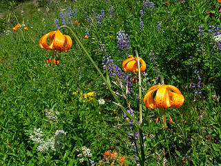 Quite the flower show up there. 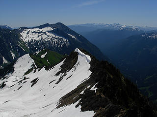 Looking back on the ridge leading to Clark Mt. 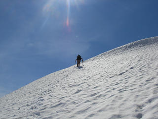 Tom crossing on of the numerous ridges 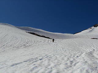 Tom on the snowfields between Clark & Tenpeak 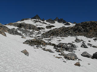 Looking at Tenpeak Mt. from Upper Thunder Basin 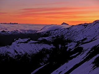 Sunset from our bivy 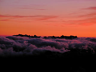 Monte Cristo group above the clouds 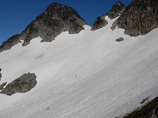 Tom traversing under Tenpeak to West Tenpeak
"There can be no greater issue than that of conservation in this country."
Teddy Roosevelt August 6, 1912
"There can be no greater issue than that of conservation in this country."
Teddy Roosevelt August 6, 1912
|
| Back to top |
|
|
Tom_Sjolseth
Born Yesterday
Joined: 30 May 2007
Posts: 2652 | TRs | Pics
Location: Right here. |
Wow, your sunset shots came out great!
@Matt, the others in Fay Pullen's party were you and MtnMike, of course. No malice intended for not mentioning you both in the TR, and I apologize, I should have included your names for a complete report. I only mentioned Fay because she was the one who placed the register. I have edited the report to include yours and Mtn Mike's names.
|
| Back to top |
|
|
Stefan-K
Member

Joined: 10 Aug 2009
Posts: 522 | TRs | Pics
Location: seattle |
|
Stefan-K
Member
|
Wed Aug 10, 2011 8:10 pm |
|
|
"The antenna strapped to his backpack is actually connected to a tiny personal locator beacon implanted in his lower back.." that's pretty funny...
super views from W. Tenpeak with the clouds and all - wow! - still want to ski that Tenpeak couloir
|
| Back to top |
|
|
Magellan
Brutally Handsome

Joined: 26 Jul 2006
Posts: 13116 | TRs | Pics
Location: Inexorable descent |
|
Magellan
Brutally Handsome
|
Wed Aug 10, 2011 9:56 pm |
|
|
Simply awesome!
|
| Back to top |
|
|
reststep
Member

Joined: 17 Dec 2001
Posts: 4757 | TRs | Pics
|
|
reststep
Member
|
Thu Aug 11, 2011 11:04 am |
|
|
Great report and pictures. I like the picture that shows Louis Creek because I hope to take that high route some time.
| silence wrote: | | btw is there some place where we can read about fay's ongoing climbs to place the summit registers? her name keeps popping up every where now .. in the olys and cascades |
I don't know of anyplace on the internet where there is a chronicle of Fay's climbs but I used to follow her reports in Pack and Paddle Magazine. I think she used to do many of the climbs solo. I don't know if she still does that.
I did come up with her report of a solo climb of Mt. Goode.
Link to Mt. Goode Report
Edit: Actually after reading the report I see Fay also climbed Storm King Mountain on the same trip. Simply amazing.
"The mountains are calling and I must go." - John Muir
"The mountains are calling and I must go." - John Muir
|
| Back to top |
|
|
|
|
You cannot post new topics in this forum
You cannot reply to topics in this forum
You cannot edit your posts in this forum
You cannot delete your posts in this forum
You cannot vote in polls in this forum
|
Disclosure: As an Amazon Associate NWHikers.net earns from qualifying purchases when you use our link(s). |


