| Previous :: Next Topic |
| Author |
Message |
Matt
Tea, Earl Grey, Hot


Joined: 30 Jan 2007
Posts: 4307 | TRs | Pics
Location: Shoreline |
|
Matt
Tea, Earl Grey, Hot
|
 Thu Sep 15, 2011 12:16 am |
|
|
Diptop Loop, August 27-28, 2011
Peaks: Diptop, Lynch, Cathedral Rock
Lakes: Marmot, No Name, Jade, Pea Soup, Peggys Pond (also Hyas & Squaw)
Party: cartman, Dicey, Matt
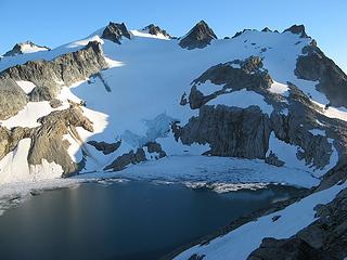
We did this trip as a loop through Diptop Pass.
From the Hyas Pass trailhead we hiked trails to Deception Pass & Marmot Lake, then way trails to Jade Lake, and finally up the snowfield to Diptop Gap, with an evening scramble up Diptop.
The next morning we pretty much carried over Lynch, then traversed over the east arm of Daniel to Peggys Pond, made a side trip up Cathedral Rock, and out via the Cathedral Pass trail.
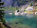
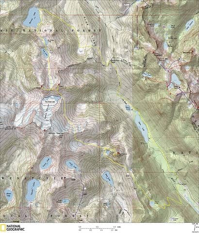 Diptop Loop Map 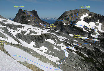 Route from Diptop Gap to Lynch to Pea Soup Lake to Daniel Arm 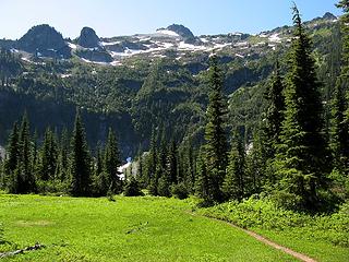 Meadow between Deception Pass & Marmot Lake 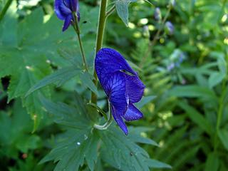 Monks Hood 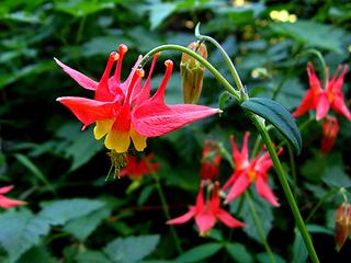 Columbine 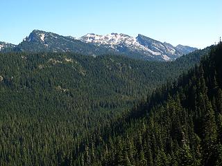 Looking back at the drop between Deception Pass & Marmot  Not quite poodles 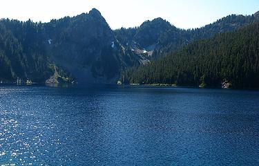 Blue Marmot 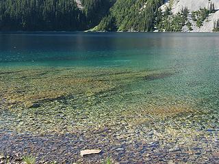 Many-colored clear Marmot 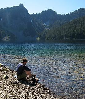 Pumping water at Marmot 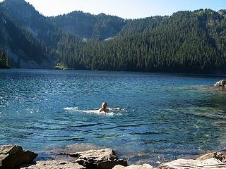 Marmot swim 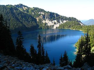 Marmot from above 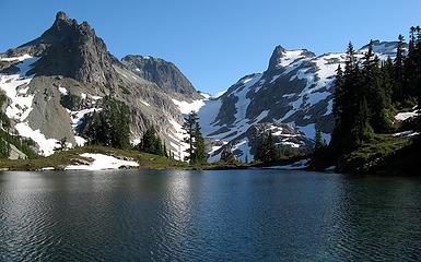 No Name Lake & Diptop Gap 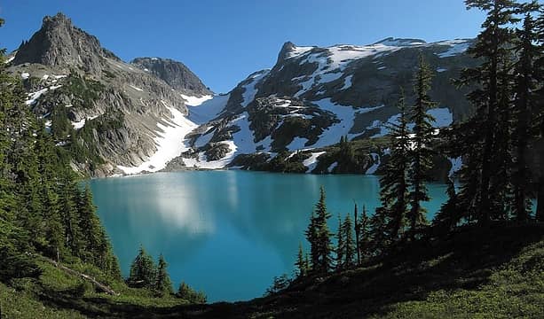 Jade Lake 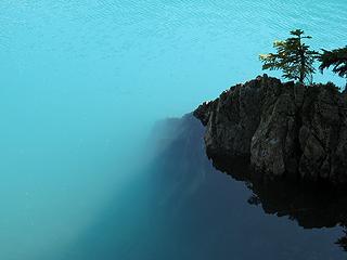 Crystal Jade Depths 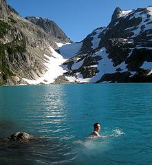 Swimming to Diptop Gap 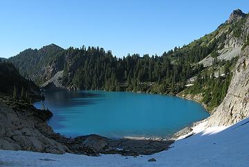 Looking back down on Jade 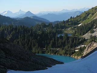 The view back (north) to Jade & No Name 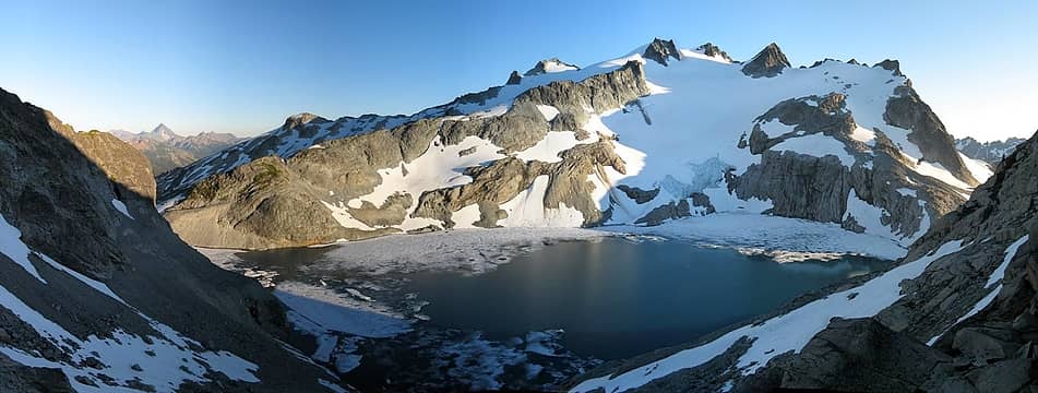 The view ahead (south) Mt. Daniel & Pea Soup Lake 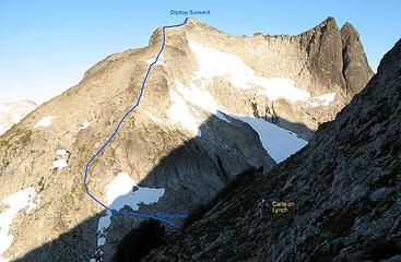 5692A Diptop Route, viewed the next day from Lynch 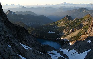 Jade & Marmot from even higher up 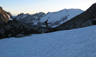 Crossing a level spot below the summit 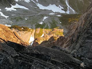 2000-foot drop down to Pea Soup outlet stream (upper East Fork Foss) 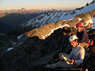 Reading the register 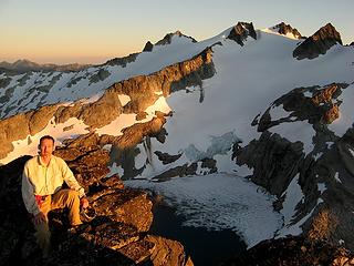 Evening summit 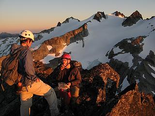 Mmm, snacks. 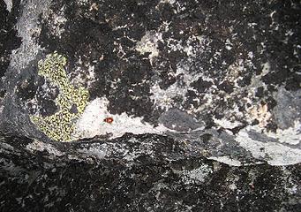 Proof of summit: ladybug 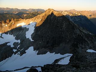 Shadow of Diptop on Lynch 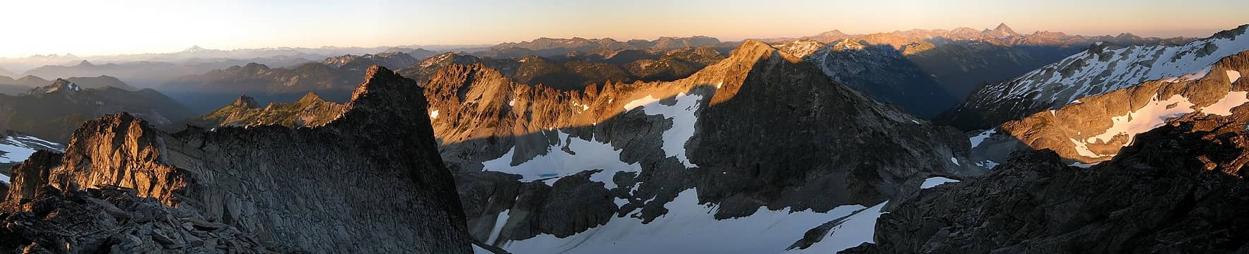 Diptop Shadows panorama 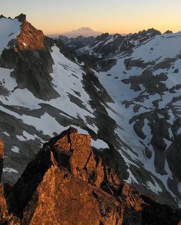 Rainier & the Snoqualmie Crest above Hinman Gap (3 Queens, Hibox, Chikamin, Lemah, Chimney Rock, Overcoat) 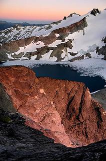 Last light through Hinman gap 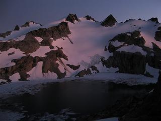 Magenta afterglow on Daniel 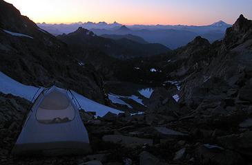 Camp falling into night 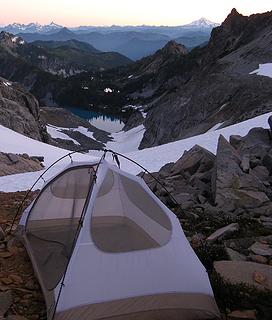 Camp lightening into day, 6:08am 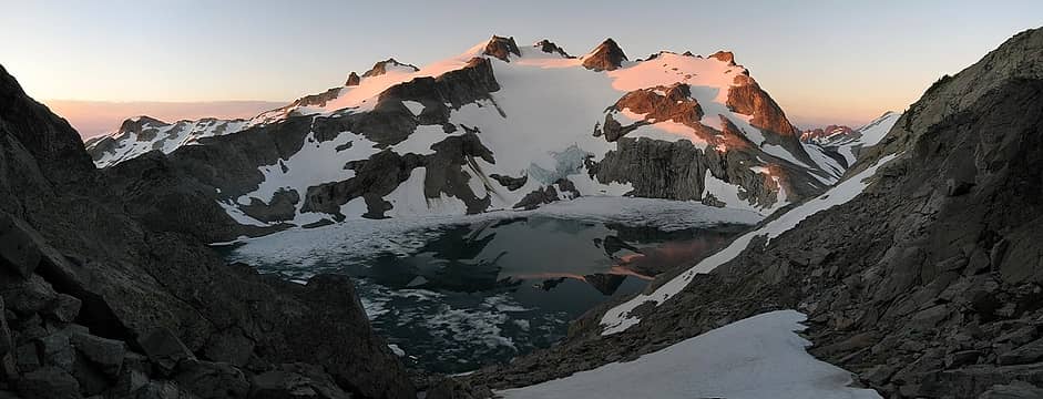 Daniel sunrise 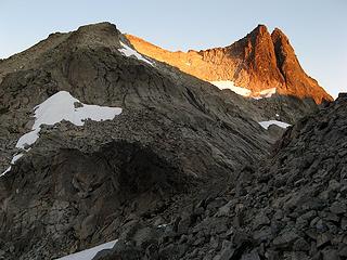 Diptop Sunrise, 6:30am 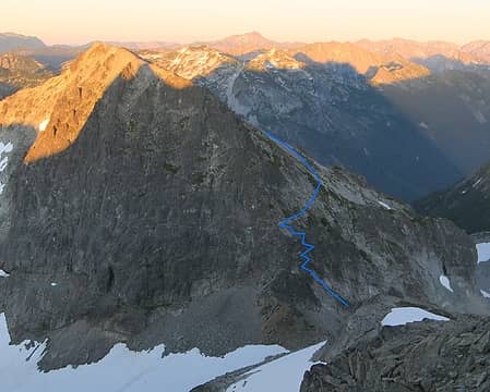 Lynch route from Diptop 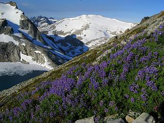 Flowers on Lynch slopes 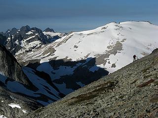 Eric on the upper slopes of Lynch 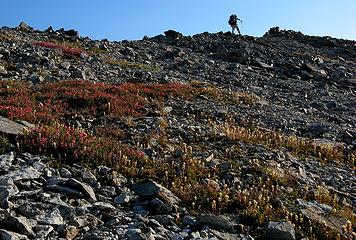 Carla on the Lynch crest 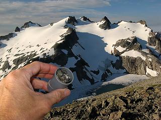 Wet film can register 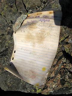 Wet Fay Pullen register book 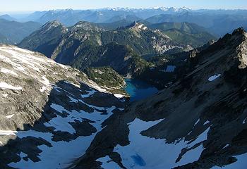 The view back north 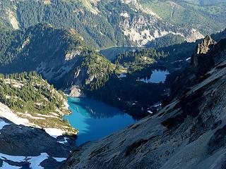 Jade, No Name & Marmot 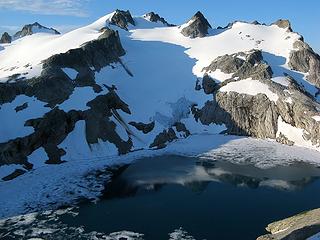 Blue Daniel 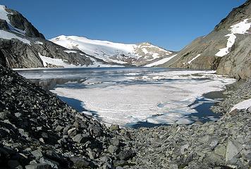 East edge of Pea Soup Lake 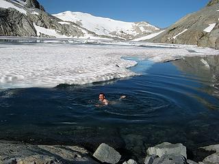 A brisk swim 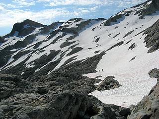 Heading up onto Daniel east ridge 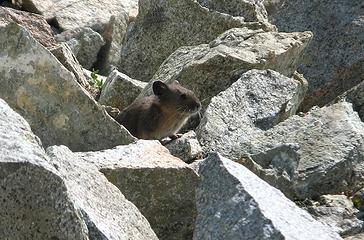 Pika on Daniel ridge crest 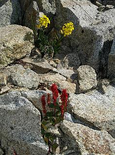 Flowers on Daniel east ridge crest 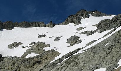 Daniel Scramblers 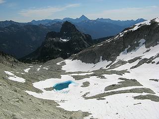 Looking down Daniels east basin 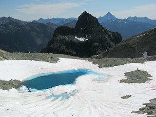 Closer to the blue tarn 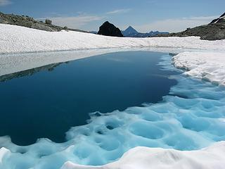 Blue tarn shoreline 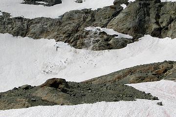 Small slab collapse avalanche 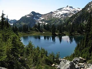 Peggys Pond 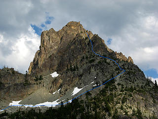 Cathedral Route 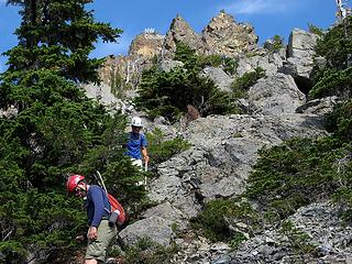 On the west ridge rock step (photo taken going down on descent) 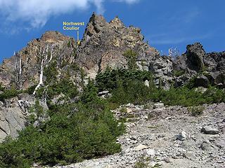 Looking up the west ridge rock band to the NW Couloir 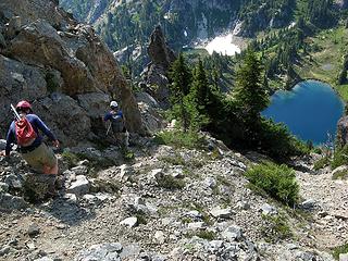 Below the NW Couloir (photo taken going down on descent) 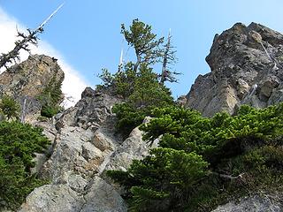 Looking up the NW Couloir (route is right of the center outcrop) 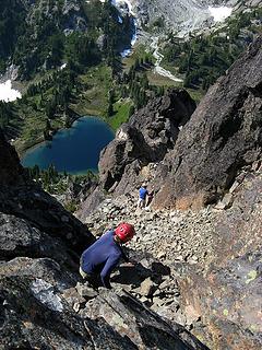 Terrain between top of couloir & base of tunnel (photo taken going down on descent) 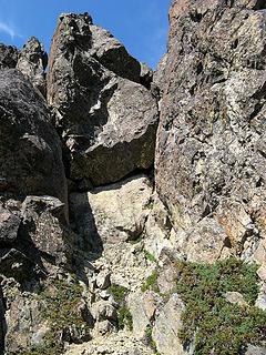 1 label The giant chockstone, with tunnel at its lower right corner 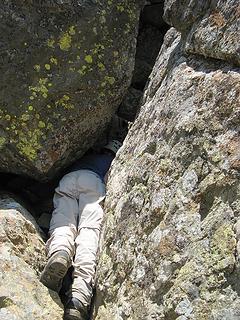 Dicey twisting into the entry (the tunnel isnt above her head, but underneath the boulder on the left) 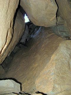 Looking up at Dicey higher in the tunnel 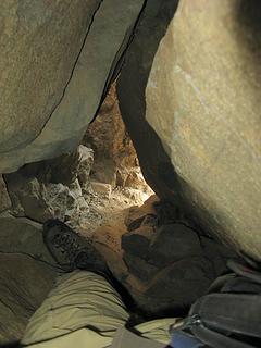 Looking down past my feet from top of the tunnel 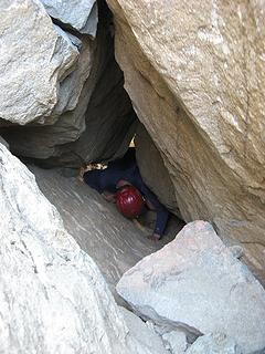 Cartman climbing the tunnel 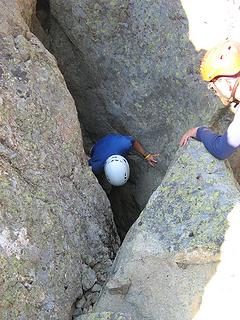 Top of the tunnel 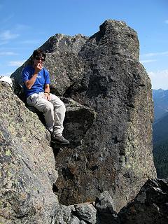 Carla sitting on a summit chockstone 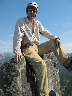 On the summit 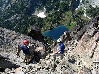 Getting off the summit, cant quite make the dive to Peggys Pond 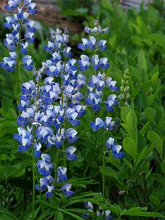 Flowers along the trail 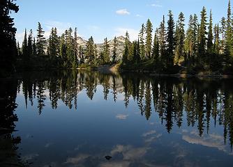 Reflections in a pond along the way
As beacons mountains burned at evening. J.R.R. Tolkien
As beacons mountains burned at evening. J.R.R. Tolkien
|
| Back to top |
  
|
|
Fletcher
Member

Joined: 29 Jul 2009
Posts: 1870 | TRs | Pics
Location: kirkland |
|
Fletcher
Member
|
Thu Sep 15, 2011 12:58 am |
|
|
When I was in that area a few weeks ago I took basically the same picture as yours from Daniel arm. I climbed up there from our campsite which was just below and thought Man! That looks like a cool area to explore. Looks like you walked right through our campsite on your way to Peggy's. Looks like a cool trip.
|
| Back to top |
|
|
iron
Member

Joined: 10 Aug 2008
Posts: 6392 | TRs | Pics
Location: southeast kootenays |
|
iron
Member
|
Thu Sep 15, 2011 1:53 am |
|
|
awesome. really like the picture "crystal jade depths"!
|
| Back to top |
|
|
silence
Member

Joined: 25 Apr 2005
Posts: 4420 | TRs | Pics
|
|
silence
Member
|
Thu Sep 15, 2011 6:16 am |
|
|
gorgeous gorgeous .. eye candy ...
PHOTOS
FILMS
Keep a good head and always carry a light bulb. Bob Dylan
PHOTOS
FILMS
Keep a good head and always carry a light bulb. Bob Dylan
|
| Back to top |
|
|
alpinelakes
Member

Joined: 07 Jun 2009
Posts: 414 | TRs | Pics
Location: Seahurst |
Exceptional report and photos. Some really nice light on some of these shots.
And an excellent map, too. Thanks.
I've been wanting to get in that way for a while... just need to decide how to get past Pea Soup Lake...Lynch, Diptop or flotation technology... I think the FS should provide rafts like they do bear cannisters... it's a safety issue for heavens sake...
Bravo for the great effort!
|
| Back to top |
|
|
Stefan
Member

Joined: 17 Dec 2001
Posts: 5091 | TRs | Pics
|
|
Stefan
Member
|
Thu Sep 15, 2011 3:44 pm |
|
|
i really like the jade lake depths too.
It is simple and elegant at the same time.
Look like you enjoyed the outing. Great!!!
|
| Back to top |
|
|
Mofro
Member

Joined: 17 Aug 2010
Posts: 17 | TRs | Pics
|
|
Mofro
Member
|
Thu Sep 15, 2011 4:01 pm |
|
|
Excellent pics!
A striking difference in the "Little Jade Glacier" from this year's cold and wet spring.
| Matt wrote: | Jade Lake |
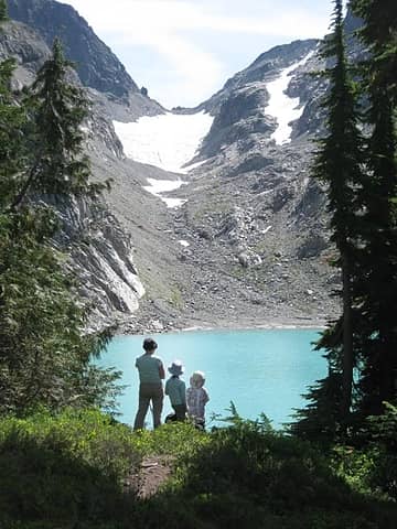 Aug 27 2009
|
| Back to top |
|
|
Dayhike Mike
Bad MFKer
Joined: 02 Mar 2003
Posts: 10958 | TRs | Pics
Location: Going to Tukwila |
What a great idea for a loop! Really nice work, guys!
"There is only one basic human right, the right to do as you damn well please. And with it comes the only basic human duty, the duty to take the consequences." -P.J. O'Rourke
"Ignorance is natural. Stupidity takes commitment." -Solomon Short
"There is only one basic human right, the right to do as you damn well please. And with it comes the only basic human duty, the duty to take the consequences." -P.J. O'Rourke
"Ignorance is natural. Stupidity takes commitment." -Solomon Short
|
| Back to top |
|
|
raising3hikers
Member
Joined: 21 Sep 2007
Posts: 2344 | TRs | Pics
Location: Edmonds, Wa |
Great pics, Looks like a great trip, I've wanted to go in that way for some time now, I'll definitely put it on the list
|
| Back to top |
|
|
Matt
Tea, Earl Grey, Hot
Joined: 30 Jan 2007
Posts: 4307 | TRs | Pics
Location: Shoreline |
|
Matt
Tea, Earl Grey, Hot
|
Fri Sep 16, 2011 1:14 am |
|
|
| iron wrote: | | awesome. really like the picture "crystal jade depths"! |
I really liked that spot, how the fin of rock dropped deep into the translucent water, and how the bar of shadow angled down through the water, and of course the little tree on top. Here are a couple other views of it.
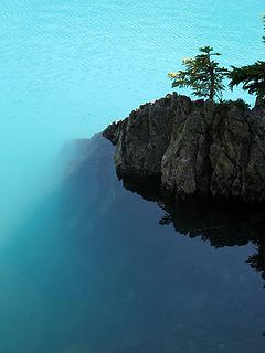 Jade Depths vertical 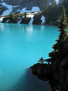 Jade Depths wider
As beacons mountains burned at evening. J.R.R. Tolkien
As beacons mountains burned at evening. J.R.R. Tolkien
|
| Back to top |
|
|
Matt
Tea, Earl Grey, Hot
Joined: 30 Jan 2007
Posts: 4307 | TRs | Pics
Location: Shoreline |
|
Matt
Tea, Earl Grey, Hot
|
Fri Sep 16, 2011 1:15 am |
|
|
I added the rest of Sunday to the report above.
From our Diptop Gap camp, it was also fascinating to watch the light shift across Daniel overnight evening shadows stretching across one side, deepening into sunset color, fading to dark at night, then ripening into sunrise colors, and morning shadows retreating across the other side.
 Evening Daniel, 7:06pm 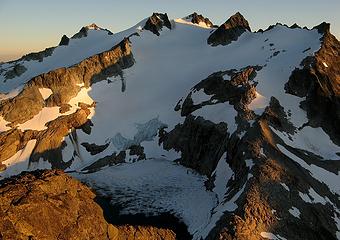 Sunset Daniel, 7:36pm 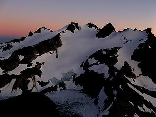 Afterglow behind Daniel, 8:00pm  Magenta Daniel, 8:22pm 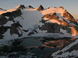 Sunrise Daniel, 6:30am  Morning Daniel, 7:36am
As beacons mountains burned at evening. J.R.R. Tolkien
As beacons mountains burned at evening. J.R.R. Tolkien
|
| Back to top |
|
|
yukon222
Member

Joined: 12 Mar 2007
Posts: 1893 | TRs | Pics
|
|
yukon222
Member
|
Fri Sep 16, 2011 8:58 am |
|
|
Very fine TR showing that incredible scenery. I really enjoyed "revisiting" the area thru your TR.
Isn't that Cathedral "tunnel" fun? Tight squeeze to get thru that but very cool to pop out so close to the summit.
|
| Back to top |
|
|
Hiker Mama
Member

Joined: 25 Jun 2006
Posts: 3451 | TRs | Pics
Location: Lynnwood |
Fabulous! (My kids saw this and totally want to go. Time to start investing in backpacking gear, I think...) Thanks for the beautiful photos.
|
| Back to top |
|
|
puzzlr
Mid Fork Rocks

Joined: 13 Feb 2007
Posts: 7220 | TRs | Pics
Location: Stuck in the middle |
|
puzzlr
Mid Fork Rocks
|
Fri Sep 16, 2011 9:22 pm |
|
|
| Matt wrote: | Jade Depths vertical |
This photo that would work great as a two-page vertical in the calendar. Don't forget!
Fantastic pictures. The ones of Cathedral Rock are vertigo-inducing. Can't wait to get there myself some day.
|
| Back to top |
|
|
Backpacker Joe
Blind Hiker

Joined: 16 Dec 2001
Posts: 23956 | TRs | Pics
Location: Cle Elum |
Great pics as usual Matt. Hey I climbed Diptop once. Closest thing to being a peak bagger I guess. LOL.
"If destruction be our lot we must ourselves be its author and finisher. As a nation of freemen we must live through all time or die by suicide."
Abraham Lincoln
"If destruction be our lot we must ourselves be its author and finisher. As a nation of freemen we must live through all time or die by suicide."
Abraham Lincoln
|
| Back to top |
|
|
|
|
You cannot post new topics in this forum
You cannot reply to topics in this forum
You cannot edit your posts in this forum
You cannot delete your posts in this forum
You cannot vote in polls in this forum
|
Disclosure: As an Amazon Associate NWHikers.net earns from qualifying purchases when you use our link(s). |


