Forum Index > Trip Reports > 9 Days from Silver Creek to Little Beaver (8/18-8/26, 2013)
 Reply to topic
Previous :: Next Topic
Author Message
Tom_Sjolseth
Born Yesterday


Joined: 30 May 2007
Posts: 2652 | TRs | Pics
Location: Right here.
Tom_Sjolseth
Born Yesterday
PostTue Aug 27, 2013 8:57 am 
The Plan It’s been a while since my Dad and I have taken a trip together into the mountains. As a youngster, trips into the mountains with Dad were frequent, and a formative part of my life. Despite being “retired” now, his schedule is busier than ever. Babysitting grandchildren, managing a game reserve in Botswana, interminable yard/house work, traveling around the globe… free time for Dad has never been at such a premium. As I begin to pursue certain professional endeavors, my availability for climbing trips will also soon be at a premium. With that in mind, we decided an extended trip into the mountains was in order. In coming up with a plan, certain things had to be taken into account. Like, for example, the fact that Dad is 69 years-old now, has an artificial knee, and is collecting Social Security. At a time when most Dads should be going to AARP meetings and getting prostate exams, mine is planning a trip into some of the most remote and rugged terrain the North Cascades has to offer. After going back and forth on destination, we ultimately decided on a trip through the Chilliwacks to try to climb some peaks on the Bulger Top 100 list, a goal of my Dad’s for quite some time. Although only 10 peaks remained for him, many of them could be considered difficult, including the Moxes and Redoubt. Above all else, we expected to share some great times in the North Cascades, a place near and dear to both of us. As the years go on, opportunities to get out together become limited, and with that in mind, we intended to make the most of it. So in the end, we decided on an 11 day traverse from Silver Creek to Little Beaver, with ambitions to climb several peaks along the way. Even if we only accomplished half of what we set out to do on this grand traverse, we would be happy for the opportunity to share some time together in one of our favorite places on earth – the North Cascades. This is the story of our journey.
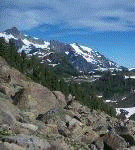
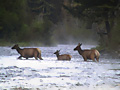
Our route.
Our route.
Day 1 We couldn’t reserve the boat heading up lake until 10AM on Sunday the 18th. Being that our day 1 was long, we needed to make good time. The boat driver did a great job of landing us along the shoreline N of Silver Creek, about ¼ mile S of the International Boundary. This is a route that worked out great for Stefan and Greg on their ascent of Devil’s Tongue [in a DAY!] in May of 2009. With 11 days worth of provisions (including rope and climbing gear), we set off up the dry forested ridge at about 11:15 AM. Travel for the first 400’ or so was hampered by tight timber resulting from past logging operations, but the forest soon opened up and easy travel ensued all the way to the ridge top. Unfortunately (for Dad) we hit several wasp nests along the way. Before reaching the ridge, he suffered at least 5 stings while I (in front) missed out on the fun. Water was scarce on the way up, and we were glad to be packing several liters each from the lake. Views along the ridge were supreme, with high green meadows adorning the flanks of Canadian hills one valley to the N. There are some ups and downs along the ridge, but the terrain is pleasant. The mosquitoes (on the other hand) were NOT! Just as Fay Pullen had mentioned in her trip report of Devil’s Tongue from Galene Lakes, the bugs for us were terrible.. some of the worst mosquitoes either of us have ever experienced. By about 5 PM, we were in camp on a flat patch of grass at a 5960’ saddle between points 6545 and 6434. After setting up the tent, I needed to find water. There was no water source and no snow patches nearby. Knowing I would probably have to go as far as the basin below Devil’s Tongue, I grabbed my headlamp and 9 liters of carrying capacity and headed out to climb Devil’s Tongue (and get water). Devil’s Tongue is still a long ways off from camp – much farther than it looks on the map with a lot of up and down and going around pinnacles and such. Along the way, I entered Canada. After paying respects to our neighbors to the North, I continued on, arriving at the summit of Devil’s Tongue at dusk (2.5 hours from camp). Due to a combination of factors, I only took one photo on day 1, a photo of the DT register, with two familiar parties signed in. I arrived back in camp with 9 liters of water at midnight. It took 3 hours to get back, mainly due to having to down climb in the dark. It was a long day for me (~8500’ gain, 5500’ of that was with a 75 pound pack!).
Devil's Tongue summit register.
Day 2 We awoke late due to light rain in the morning. We were headed down into the brush, and we had hoped to give it time to dry out. By about 10AM, we were moving, descending into Silver Creek. Our goal for today was to find a route up into Silver Lake via an obvious bench between 4400’-4600’. When we reached the bench, it began to rain again. We decided to sit it out rather than get completely soaked in the brush on day 2 of an 11 day trip. After sitting around for about 4 hours, the rain finally let up and the sun came out, drying out the brush fairly fast. We again moved on, but now it was 3PM and routefinding was getting tricky. We kept hitting walls and buttresses and deep clefts that didn’t show on our USGS map. At one point, we made a rappel in the forest. Frustrated, we decided to call it a day early and set up camp in a rocky cleft on a good, flat slab at 4500’.
Rocky Cleft Camp.
Rocky Cleft Camp.
Day 3 Today, we needed to get to a camp on the W end of Silver Lake. We had talked to only a couple of people who had been up the headwall before, and they both said it was brushy. “Godawful” is one adjective used to describe it by a well-known local climber. I would definitely say godawful is an apt descriptor of the route up the Silver Creek headwall. In fact, in terms of tough approaches in the Cascades, I think Silver Creek ranks highly. Other approaches traditionally thought of as difficult (such as the route up the Barrier into Crescent Creek Basin, Access Creek, Eiley/Wiley Ridge, etc.. pale in comparison). Steep forest sprinkled with slick duff laced with dense brush interspersed with class 3-4 rock capped with a smattering of voracious insects just about sums it up. My Dad (who has done some of the most heinous bushwhack lake approaches in the range) said this was the most difficult approach he has ever done. Maybe it’s because we had 11 days worth of gear.. or maybe it’s because we’re soft. Either way, I agree. After passing a few amazing waterfalls, we soon broke out of the brush and came to heavenly open heather slopes high above Silver Creek and Ross Lake. Our moods lightened and we bounced up towards Silver Lake. Our first view of Silver Lake was jaw-dropping. Definitely the most beautiful lake I’ve ever seen. I had been eager to get back here ever since my first visit to the lake 10 years prior. Getting around Silver Lake was surprisingly easy, beginning high, then doing a descending traverse to the shore line, completing the last half of the traverse within 12” of the shore. We found an amazingly flat, clean rock slab within 100’ of shore that night for camp. The bugs were very light, and we were finally able to enjoy ourselves.
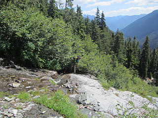
Dad escaping the brush.
Dad scrambling high above Silver Creek.
Waterfalls on the approach.
The only open terrain we found on the headwall.
Looking back down on Silver Creek.
Cliffs looming above us on the approach.
Cliffs below Devil's Tongue.
Upper Silver Creek.
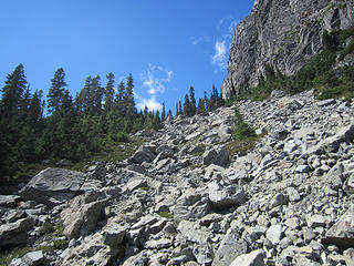
Upper Silver Creek.
TheSilver Creek drainage.
Steep walls at the head of Silver Creek.
Moss.
Moss.
Devil's Tongue and a tarn.
Silver Creek Headwall Falls.
More falls.
More falls.
More...
More...
Dad on the approach.
Dad in front of a glorious Silver Lake.
Did I mention glorious?
Dad having a break below Devil's Toothpick.
Beautiful Silver Lake.
Can there be too many Silver Lake shots?
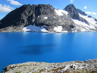
Silver Lake and Spickard.
Silver Lake.
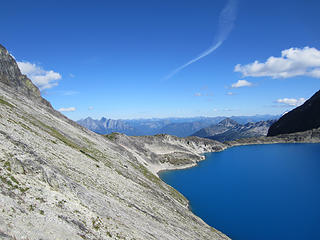
Silver Lake.
Boot shot w/ Silver Lake.
Silver Lake!
Silver Lake!
Guess who?
Guess who?
Dad traversing Silver Lake.
Happy Dad.
Happy Dad.
Flowers and Silver Lake.
Dad and Silver Lake reflection.
View from camp.
View from camp.
Silver Lake.  Again.
Silver Lake. Again.
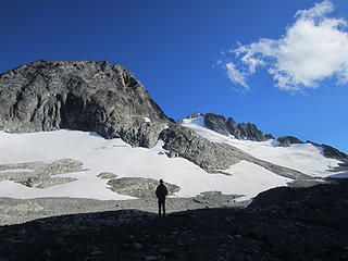
Dad silhouetted against the N side of Spickard.
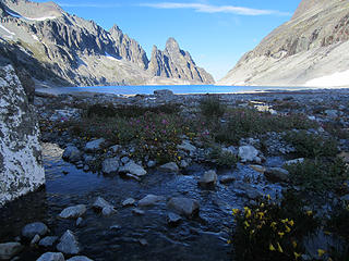
Silver Lake yet again.
11 days worth of gear = 75 pounds.
Dad at camp.
Dad at camp.
This never gets old.
Tent shot!
Tent shot!
Day 4 Day 4 dawned clear, and we headed up towards the pass between Custer and Spickard. Here, we dropped our packs and continued on towards the summit of Custer. I didn’t remember the traverse to Custer being as crappy as it was, but sure enough – it is! The views to the lake and surrounding peaks from Custer’s summit are amazing. After signing the register, we headed back down to our packs. One interesting thing though.. as we were up on the ridge, we saw a helicopter fly up to Silver Lake from Depot Creek and land pretty much directly where we were camped the night before. One man got out, went to the water, got a sample and hopped back in the chopper. The chopper then flew off to the E towards Hozomeen. See photos below of chopper.. Satisfied, we decided to call it a day and set up camp on a beautiful heather bench amid a grove of larches, about 400’ below the Silver Lake Col. That evening we enjoyed a great sunset over the Chilliwack Lake Valley.
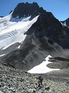
Dad on the way up Mt Custer.
The view of Silver Lake from partway up Custer.
Moxes and Redoubt from Custer.
Silver Lake from the route up Custer.
On the way to Custer.
Dad scrambling high on Custer Ridge.
Chopper landing at Silver Lake.
Chopper flying over Silver Lake.
Dad high on Custer Ridge.
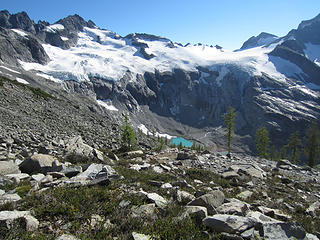
Ouzel Lake below from camp.
Camp.
Camp.
Sunset at camp.
Sunset at camp.
Day 5 Today we had planned to climb Spickard, then head to camp at 7200’ on the Redoubt Glacier to set up for the Moxes and Redoubt. That morning, while listening to the forecast on the radio, the weather appeared to be headed south over the course of the next few days. After much discussion, my Dad and I ultimately decided to forgo Spickard and instead climb the more difficult NW Mox that day on the way to Redoubt Camp. Instead of dropping all the way to Ouzel Lake and going back up the other side, we settled on a high traverse under the flanks of Spickard – which worked out quite well. One obstacle – a 35’ glacier ice step – caused us a bit of a problem, but we were able to work through it with a little bit of ingenuity. Soon we found ourselves headed up NW Mox. Along the way we had some excitement when a ~5000# boulder broke free from a gully I was climbing. I was being careful around it because I knew it was barely perched, but only a slight nudge was all it took to send it into motion. It cracked my brand new helmet and left me with some abrasions, but I was able to jump out of the way in time. I understand that these are risks we take while climbing, and they are risks I am willing to accept. In retrospect, despite recognizing the potential threat ahead of time, I should have been even more careful and not touched the boulder at all. Lesson learned.. thankfully only at the expense of a few scratches. The sidewalk in the sky that is the route up NW Mox was every bit as enjoyable as I had remembered it from before. Beautiful views in both directions, relatively solid and fun scrambling, followed by an exciting summit pitch all make this a really great climb. The summit register here is falling apart.. the cap is cracked wide open and the ziplock bag is full of holes. This peak appears to be getting a lot of traffic lately as evidenced by its busy register that was only recently placed. The retreat back to the glacier and our packs was uneventful, and we continued on to camp at 7200’ by maintaining a high traverse.
Mt Redoubt from the high traverse to NW Mox.
Dad on NW Mox.
Dad on NW Mox.
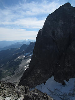
SE Mox.. the Devil's Club (E Face).
Dad on NW Mox.
Dad on NW Mox.
The crux pitch on NW Mox.
Dad relaxing on the summit of NW Mox.
Dad descending NW Mox.
IMG_4842
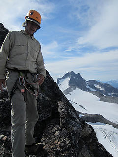
IMG_4842
Dad traversing Redoubt Glacier on the way to camp.
Dad on Redoubt Glacier.
Views from Redoubt Camp at dusk.
Rustic Ridge.
Rustic Ridge.
Day 6 Our goal for today was to climb Redoubt. When we awoke, the weather was iffy at best. Clouds swirled all around, and it threatened to rain all morning. Being unsure what the weather was going to do, we hung out around camp for a bit to see if things would improve. Things did improve slightly as the day went on, enough so that we felt OK heading out to climb Redoubt. Routefinding up Mt Redoubt was a bit of a challenge, despite having climbed it before (7 years ago). Near the top I strayed too far right and we wound up on some 5.7ish loose rock. I should have moved one gully left to climb through the cannonhole (we never did climb through the cannonhole). After signing in one of two summit registers (??), I proceeded to leave my ice axe on the summit. Not noticing until I got down and running out of daylight due to our late start, I didn’t have time to go back and get it. The descent back to camp on loose talus was unpleasant.. more so than I remember from last time I climbed it. They say the memory is the first thing to go. That night it rained a little bit. Signs of things to come?
Dragonfly with Redoubt's Flying Buttress behind.
The gully on Redoubt.
Dad climbing Redoubt.
Redoubt summit register.
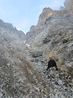
Dad descending Redoubt.
Views from the S side of Redoubt.
Bear and Bear Lake from Redoubt.
Evening glow on Redoubt.
Mystical clouds on Bear.
More views from Redoubt.
Dad descending Redoubt.
Looking towards Bear at dusk.
Dad descending to camp.
Day 7 Today’s goal was to climb SE Mox, but things were damp when we awoke and it was cloudy and breezy. Hanging over our heads was the uncertainty of what the weather would bring in the days to come, and the fact that we were still a minimum of 3 days in from our exit point at Little Beaver. After much discussion, we reluctantly pulled the plug on SE Mox and decided to continue on closer to Whatcom Pass in case the weather completely deteriorated and we had to make a dash for it. The weather continued to be cloudy all day, and by 2PM, it began to drizzle. Traversing some of the loosest talus I’ve ever seen while wet was a challenge to say the least. If ever there were terrain that mandated the use of trekking poles, the area between Redoubt Col and Cave Lake is it! Loose, steep, and wet. Find an adjective that is the exact opposite of fun and you would be completely justified in applying it to this traverse. Luckily, the traversing is short-lived, and we soon found ourselves at Cave Lake. The drizzle began to intensify a bit, so we decided to set up the tent to get out of the rain. Eventually we decided to just camp here at Cave Lake on a beautiful heather bench with great views to Challenger and the Pickets. The rain eventually let up and the sun came out. We were happy to have the intensity of the August sunshine to dry out some of our gear and fuel us with motivation.
Rustic (Pt 7747).
Rustic (Pt 7747).
Looking at Mox Peaks in swirling clouds.
Cloudy camp views.
Cloudy camp views.
Rustic Peak in the clouds.
Looking out towards Jack and Prophet.
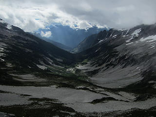
Looking down into Redoubt Creek.
Bear Lake.
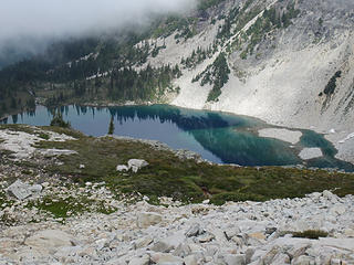
Bear Lake.
Bear Lake (again).
Bear Lake (again).
Talus hell.  Poles REQUIRED.
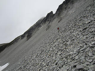
Talus hell. Poles REQUIRED.
How long do you think this cairn will last?
Cave Lake.
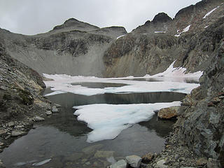
Cave Lake.
Cave Lake outlet.
Cave Lake outlet.
Cave Lake.
Cave Lake.
Day 8 Today dawned clear, much to our surprise! We were up early and off to a camp somewhere around Tapto Lakes, where exactly we didn’t know. The traverse here is especially scenic, with splendid views in all directions. Chilliwack Lake, Mt. Challenger, The Pickets, Bear Mountain, Shuksan.. all the peaks were out and basking in the summer sun. After a brief bout with crappy talus again, we gained the ridge and left it all behind. We would stay on this high ridge all the way to our next camp high above Middle Lakes. As we neared camp, skies began to cloud up again, and the telltale sign of impending weather – lenticular clouds – engulfed nearby peaks. There was no question weather was coming in, and we were happy with our decisions to forgo peaks and accelerate our schedule. We set up camp on a splendid patch of grass on a high ridge at ~6400’ with commanding views of a very close Mt. Challenger and Whatcom Peak. That evening, the clouds continued to build. Listening to the weather forecast, things had gotten considerably worse, and they were predicting an incoming storm with high winds in the Strait and showers in Seattle (w/ rain in Vancouver). Sure enough, it rained hard and steady all night.
Views from Cave Lake Camp.
Challenger from Cave Lake Camp.
Luna to Challenger.
Luna to Challenger.
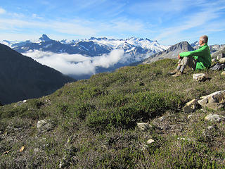
Dad enjoys the morning views.
Traversing towards Whatcom Pass from Cave Lake.
High heather meadows.
Challenger.
Challenger.
Dad enjoying some high alpine rambling.
Looking down into Pass Creek.
Dad traversing to our final camp above Middle Lakes.
High alpine roaming.
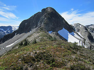
Pt 6874t.
Pt 6874t.
Expansive views.
Expansive views.
East Lakes.
East Lakes.
Looking down into East Lakes.
Dad scrambling on the traverse.
Whatcom Peak and Pass.
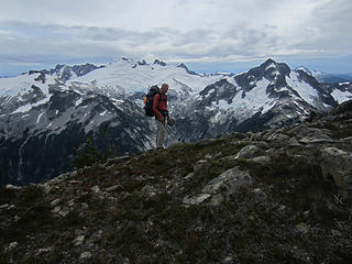
Dad wondering why it's getting so cloudy.
Looking N to Chilliwack Lake.
Chilliwack Lake.
Chilliwack Lake.
This will do.
This will do.
Day 9 Although we were so close to Redface and Indian Peaks, two goals of ours for this trip, the steady soaking rain and threat of even worsening conditions caused us to cut things short and head out to Little Beaver Landing. The brush on the way down to Whatcom Pass was all wet, and we were completely soaked by the time we hit the pass. We didn’t stop until getting to Ross Lake 18 miles later. Luckily we were able to get one of the pleasure boaters to inform Ross Lake Resort that we were ready to be picked up early. Within 2 hours, the boat arrived and picked us up. The whole trip back to the dam we were engulfed in heavy rain and winds.
Hiking out from Whatcom Pass into Little Beaver Valley.
Below Whatcom Pass.
Below Whatcom Pass.
Challenger Glacier from Little Beaver.
Clouds putting on a show in Little Beaver Valley.
Despite not accomplishing all of our climbing goals on this traverse, we accomplished the one goal that counted most: spending time together as Father and Son. To me, this beats ticking off peaks on a list. One interesting thing to note: we didn't see a single person the entire trip (except for the guy who got out of the chopper). I hope you enjoy the words and photos. TRIP STATS: UNKNOWN – Will try to figure out later.

Back to top Reply to topic Reply with quote Send private message
fox212
lost in the woods...


Joined: 24 Jun 2011
Posts: 232 | TRs | Pics
Location: Bham
fox212
lost in the woods...
PostTue Aug 27, 2013 9:18 am 
Way to go!! up.gif up.gif Can't beat a father and son adventure through the North Cascades. Very inspiring.

Back to top Reply to topic Reply with quote Send private message
gb
Member
Member


Joined: 01 Jul 2010
Posts: 6310 | TRs | Pics
gb
Member
PostTue Aug 27, 2013 9:31 am 
Tom_Sjolseth wrote:
we accomplished the one goal that counted most: spending time together as Father and Son. To me, this beats ticking off peaks on a list.
That sounds great, Tom. You are lucky to have a father that likes to share adventures with you. To bad about the rain, but that will soon be forgotten.

Back to top Reply to topic Reply with quote Send private message
twodogdad
Member
Member


Joined: 21 Nov 2006
Posts: 846 | TRs | Pics
Location: seattle
twodogdad
Member
PostTue Aug 27, 2013 9:55 am 
You two are the most admirable father-son team! Thoroughly absorbing and instructive report. Thanks, Tom & Dad. N

Back to top Reply to topic Reply with quote Send private message
Jetlag
Member
Member


Joined: 17 Aug 2010
Posts: 1410 | TRs | Pics
Jetlag
Member
PostTue Aug 27, 2013 10:06 am 
This TR just lit up my whole rainy morning! Loved the pictures of Silver Lake. Several were spectacular - 4659, 4697, 4735 - I've looked down on the lake but now I want to be on the shore! Good to know the traverse under Spickard without dropping to Ouzel is feasible. That looked pretty rubbly from lower down, but saves a few miles not having to approach NW Mox from the other side of the Redoubt glacier. Picture 4838 really captures the "sidewalk in the sky" route to NW Mox. We were buzzed by Rufous hummingbirds here. From the summit I saw an even longer sidewalk section leading over to the Ridge of Gendarmes. 5006 is a stunning picture of the Challenger glacier expanse; 5054 is not so shabby either! What an interesting photo of a dragonfly - 4899. Last, so glad that the falling boulder didn't beat you up any worse. I can't begin to explain what it's like for a father climbing with his son to experience that.

Back to top Reply to topic Reply with quote Send private message
HitTheTrail
Member
Member


Joined: 30 Oct 2007
Posts: 5458 | TRs | Pics
Location: 509
HitTheTrail
Member
PostTue Aug 27, 2013 11:06 am 
Tom, There is a lot I can identify with in this post. Your father and I are about the same age, I agree with his philosophy that if you don’t keep moving you will stop, and hiking trips with my kids are becoming less frequent but still my favorite activity. About the only thing I had trouble with is the concept of a 75 lb pack. But still a great inspiring TR. Thanks for sharing this very personal experience. up.gif up.gif

Back to top Reply to topic Reply with quote Send private message
DIYSteve
seeking hygge


Joined: 06 Mar 2007
Posts: 12655 | TRs | Pics
Location: here now
DIYSteve
seeking hygge
PostTue Aug 27, 2013 11:20 am 
Wow up.gif Gotta get out the map and see how you hooked that up.

Back to top Reply to topic Reply with quote Send private message
Backpacker Joe
Blind Hiker


Joined: 16 Dec 2001
Posts: 23956 | TRs | Pics
Location: Cle Elum
Backpacker Joe
Blind Hiker
PostTue Aug 27, 2013 11:39 am 
All youre missing is an "S" on your chest. Another great adventure. up.gif

"If destruction be our lot we must ourselves be its author and finisher. As a nation of freemen we must live through all time or die by suicide." — Abraham Lincoln
Back to top Reply to topic Reply with quote Send private message
Tom
Admin


Joined: 15 Dec 2001
Posts: 17853 | TRs | Pics
Tom
Admin
PostTue Aug 27, 2013 11:50 am 
Nice!

Back to top Reply to topic Reply with quote Send private message
Don
Member
Member


Joined: 25 Apr 2005
Posts: 2013 | TRs | Pics
Location: Fairwood, WA
Don
Member
PostTue Aug 27, 2013 11:54 am 
Awesome TR, both in pics and words, Tom. It must have been a great experience to share with your dad, and the memories will last a lifetime. On top of that, what a fantastic trip!

Back to top Reply to topic Reply with quote Send private message
jboealps
Member
Member


Joined: 10 Aug 2006
Posts: 71 | TRs | Pics
Location: Seattle
jboealps
Member
PostTue Aug 27, 2013 12:01 pm 
Great Trip and Report !javascript:emoticon('up.gif')

Back to top Reply to topic Reply with quote Send private message
Bedivere
Why Do Witches Burn?


Joined: 25 Jul 2008
Posts: 7464 | TRs | Pics
Location: The Hermitage
Bedivere
Why Do Witches Burn?
PostTue Aug 27, 2013 12:14 pm 
That's a helluva trip, thanks for sharing! Too bad about the weather, but still a very cool accomplishment and I'm sure you'll always remember it. Kudos to your dad for getting it done with the bionic knee, too. Man, I sure hope to still be getting after it like that at his age.

Back to top Reply to topic Reply with quote Send private message
Goats Know
Gravity's Bitch


Joined: 29 Aug 2007
Posts: 194 | TRs | Pics
Goats Know
Gravity's Bitch
PostTue Aug 27, 2013 12:56 pm 
Quote:
As I begin to pursue certain professional endeavors, my availability for climbing trips will also soon be at a premium.
Look out Tom! It's a trap!! smile.gif Another great trip and trip report! up.gif

Here on this mountaintop...Woahoho...I got some wild, wild life - Talking Heads
Back to top Reply to topic Reply with quote Send private message
b00
Member
Member


Joined: 29 Sep 2003
Posts: 1144 | TRs | Pics
b00
Member
PostTue Aug 27, 2013 1:57 pm 
Tom_Sjolseth wrote:
Routefinding up Mt Redoubt was a bit of a challenge, despite having climbed it before (7 years ago). Near the top I strayed too far right and we wound up on some 5.7ish loose rock. I should have moved one gully left to climb through the cannonhole (we never did climb through the cannonhole).
tom, you are awesome. i sure envy your father. being able to spend quality and quantity time with your kids is so lucky. i did a similar route to you on redoubt, one gulley to the right which led us to the ridge and north face. phil had done that route 3 times previously, never going through the cannonhole. his route goes onto the north face, is mostly third class, with a move or two that might be 4th, that brought us to the cannonhole and then up to the summit the way everyone goes from the cannonhole. it was kind of interesting and fun and i was very glad not to encounter loose 5.7 or i never could have reached the summit. i sure wish i could be a climber like you. for devils tongue, where did you find water? how far was it from your camp? do you think that water source will be there later in the fall(after the mosquitos die down)? was there snow on the devils tongue route?

Back to top Reply to topic Reply with quote Send private message
DIYSteve
seeking hygge


Joined: 06 Mar 2007
Posts: 12655 | TRs | Pics
Location: here now
DIYSteve
seeking hygge
PostTue Aug 27, 2013 2:09 pm 
Thanks for posting the map, Tom. Your route on the E flank on the N part of the Indian Creek/Pass Creek divide looks like that one described in R&R (which T&C did not actually do but scouted from the air). Very cool that you ran the top of the divide all the way to above Middle Lakes.

Back to top Reply to topic Reply with quote Send private message
   All times are GMT - 8 Hours
 Reply to topic
Forum Index > Trip Reports > 9 Days from Silver Creek to Little Beaver (8/18-8/26, 2013)
  Happy Birthday treasureblue, CascadeSportsCarClub, PYB78, nut lady!
Jump to:   
Search this topic:

You cannot post new topics in this forum
You cannot reply to topics in this forum
You cannot edit your posts in this forum
You cannot delete your posts in this forum
You cannot vote in polls in this forum