| Previous :: Next Topic |
| Author |
Message |
mosey
Member


Joined: 18 Dec 2018
Posts: 163 | TRs | Pics
|
|
mosey
Member
|
 Sat May 28, 2022 8:57 pm |
|
|
| zimmertr wrote: | | Spent 2 hours schwacking in the rain with EternalBlue trying to find the CCC cabin today. Didn't find it but did find some enormous trees and lots of bear poop. |
If you found the big trees, you're close assuming you're referring to the gingerbread cabin. But someone bashed some support beams two years ago and it has fallen down since. The grove is much more interesting imo. Even when it was still intact, you couldn't see the cabin until you're ten feet away.
 zimmertr zimmertr
zimmertr |
| Back to top |
  
|
|
Now I Fly
Member
Joined: 07 Jun 2018
Posts: 467 | TRs | Pics
|
wyattmullen, RichP, zimmertr  KascadeFlat KascadeFlat |
| Back to top |
|
|
awilsondc
Member

Joined: 03 Apr 2016
Posts: 1324 | TRs | Pics
|
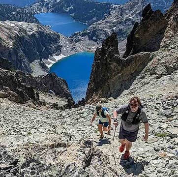
Big Craggy and West Craggy Peaks - 6/11/22
These peaks got a lot of attention over the weekend, probably because it was one of the few areas in the state with a decent forecast! The sunshine was glorious, and it was a beautiful day! We took the ridge up to Big Craggy which was the way to go for sure given the conditions. We caught up with another party on the summit of Big Craggy, but didn't stay long. The traverse over to West Craggy was my favorite part, great views and interesting mixed terrain. There was wallowing in soft snow, consolidated snow, scrambling, and some choss. Good views from West Craggy too! The descent down the "magic ramp" was a little spicy on steep snow. A mix of nice consolidated snow and thigh deep post holing got us back to the trail. It was so nice to have some sun!
Snuffy, wyattmullen, RossJames, Now I Fly, LukeHelgeson, RichP, zimmertr, jaysway, Route Loser  ngie ngie
Snuffy, wyattmullen, RossJames, Now I Fly, LukeHelgeson, RichP, zimmertr, jaysway, Route Loser ngie |
| Back to top |
|
|
zephyr
aka friendly hiker

Joined: 21 Jun 2009
Posts: 3370 | TRs | Pics
Location: West Seattle |
|
zephyr
aka friendly hiker
|
Tue Jun 14, 2022 9:08 am |
|
|
| awilsondc wrote: | |
Geez Louise!
|
Great framing.
Such a beautiful day up there. ~z
RossJames, awilsondc
RossJames, awilsondc |
| Back to top |
|
|
RichP
Member

Joined: 13 Jul 2006
Posts: 5634 | TRs | Pics
Location: here |
|
RichP
Member
|
Tue Jun 14, 2022 10:56 am |
|
|
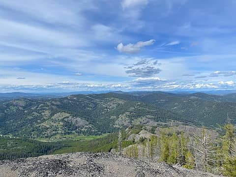
BCRT with WTA starting at Sweat Creek Picnic Area (Defunct) to Clackamas Mountain and Maple Mtn. June 9-12, 2022.
This is a section of The PNT that climbs up from the north side of Highway 20 about 30 miles east of Tonasket and 8 miles west of Republic. I got in a few peaks before and during. Fir Mtn has a trail to the top and is directly across the highway from Sweat Ck TH. Clackamas has a trail nearly to the top as does Maple. An active grazing allotment ensures that cow pies and moos are almost always present.
Sweat Ck is strange in that a nice FS sign indicates that it is a picnic area but it is not, and there is no sign indicating a trailhead, which it is. There is a very nice (and clean) restroom that seems popular with passing motorists. It was also a campground at some point but it is no longer.
A nice 10ish mile loop can be made from here up The PNT and down the Clackamas Mtn Trail. The FS does not want The Clackamas Mtn Trail to be maintained anymore due to illegal motorized use but I've heard that it's still passable.
 Looking north to Clackamas Mtn, 5280 and Maple Mtn from Fir Mtn 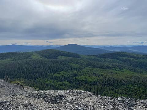 Mt Annie from Fir 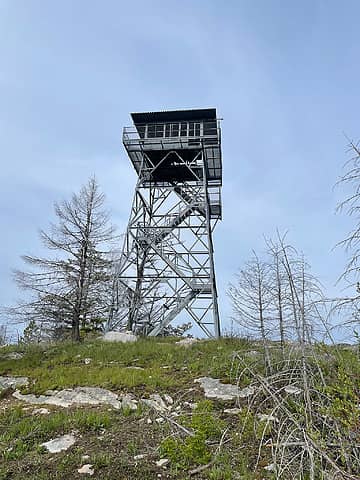 Cornell Butte Lookout. Notice the holes burnt in the flooring 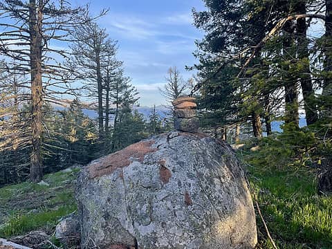 Storm King summit 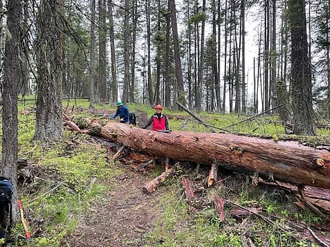 The biggest log 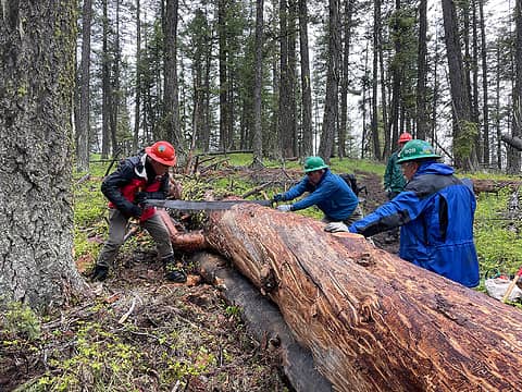 Sawing away 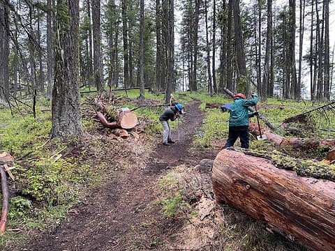 After the cut 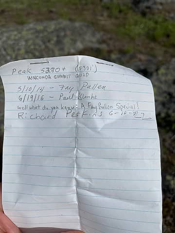 Summit register 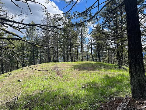 Summit of Maple Mtn 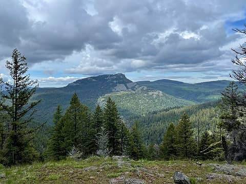 Fir Mtn from 5280 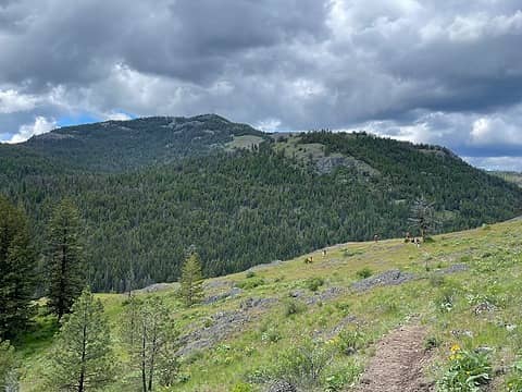 Fir Mtn on the hike out
ngie, Snuffy, jaysway, mosey, Now I Fly, HikingBex, JimK
ngie, Snuffy, jaysway, mosey, Now I Fly, HikingBex, JimK |
| Back to top |
|
|
Fletcher
Member

Joined: 29 Jul 2009
Posts: 1870 | TRs | Pics
Location: kirkland |
|
Fletcher
Member
|
Thu Jun 16, 2022 10:02 am |
|
|
Quick conditions report for the East-Central Pasayten. We finally decided to pull the trigger on a big trip out of Billy Goat, over the Fool Hens and Bauble Butte, out to Sheep, then to Two Point and Skepticle before taking the valley back to the trailhead. Well
it was not to be.
The road to the trailhead and even the trail was logged out to Bill Goat Pass last week, but it was just our luck that a massive blowdown came down in the last few days from just before Copper Glance, so we had to walk from there. We made decent time up to the pass and Pk 7967 and onward to Burch Mtn. This is where the postholing began. Wed be walking on decent spring snow for 50 yards or so, and then without warning, plunge down to our wastes. This persisted to the summit of Burch. Beyond that, on our way to Little Fool Hen, the intermittent postholing just continued and our traverse to Fool Hen began to feel like a fools errand. We decided to bail when it was still convenient. Direct and unpleasant route back down to the valley and the car by 7:30.
This disappointing start to the season continues. I suppose Im thankful that we seem to be in a good place in terms of fire season
LukeHelgeson, Michael Lewis, RichP, Now I Fly, geyer
LukeHelgeson, Michael Lewis, RichP, Now I Fly, geyer |
| Back to top |
|
|
thunderhead
Member

Joined: 14 Oct 2015
Posts: 1519 | TRs | Pics
|
| RichP wrote: | Sawing away |
What saw is that? How long did it take you to make those cuts?
|
| Back to top |
|
|
RichP
Member
Joined: 13 Jul 2006
Posts: 5634 | TRs | Pics
Location: here |
|
RichP
Member
|
Sun Jun 19, 2022 3:09 pm |
|
|
| thunderhead wrote: | | What saw is that? How long did it take you to make those cuts? |
I don't know the brand but like most good saws, its pre 1930. AFAIK crosscut saws, at least quality ones, are no longer produced. It belongs to our crew leader, Holly and she named it "Princess." Those cuts take approximately 30- 45 minutes on a log like that. We had to make three cuts on this log and it took nearly 3 hours to get it all done with a crew of 8.
zimmertr, Tom
zimmertr, Tom |
| Back to top |
|
|
zimmertr
TJ Zimmerman
Joined: 24 Jun 2018
Posts: 1228 | TRs | Pics
Location: Issaquah |
|
zimmertr
TJ Zimmerman
|
Sun Jun 19, 2022 5:46 pm |
|
|
Went up Iron Peak in the Teanaway today. Fourth weekend in a row I've grabbed a summit or two there. First time the snow wasn't crappy though. It's very well consolidated and melting fast. Will probably be gone in a couple weeks.
Mighta saw Ozzy at the DeRoux trailhead?
Flickr | Strava
Snuffy, RossJames, RichP, jaysway, mosey KascadeFlat
Flickr | Strava
Snuffy, RossJames, RichP, jaysway, mosey KascadeFlat
|
| Back to top |
|
|
RichP
Member
Joined: 13 Jul 2006
Posts: 5634 | TRs | Pics
Location: here |
|
RichP
Member
|
Fri Jun 24, 2022 11:26 am |
|
|
Rode/pushed the bike up to Ten Four yesterday. Started at the unmarked logging road off of Ben Howard south of Sultan known as 297th. It was a grunt but the ride down was energizing.
Stopped by the lookout site on Haystack Ridge along the way. Scenic views from all the clearcuts.
 Airplane Lake  Da top
Now I Fly, Bramble_Scramble KascadeFlat
Now I Fly, Bramble_Scramble KascadeFlat |
| Back to top |
|
|
HikingBex
Member
Joined: 17 Aug 2020
Posts: 110 | TRs | Pics
|
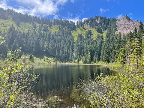
Mount Shuksan via Sulphide Glacier 6/24-25 with the Mountaineers
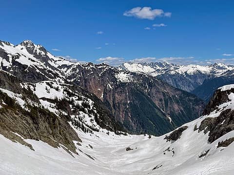 view to the east when you pop over the ridge 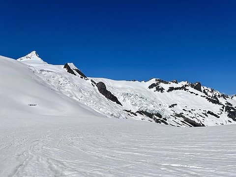 view of Shuksan from camp 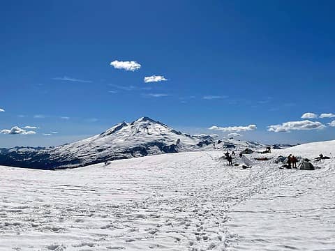 Baker from camp 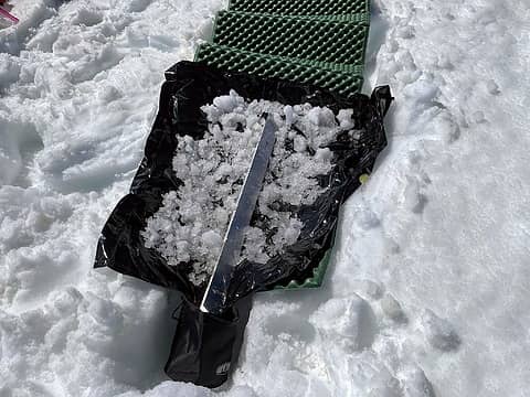 tried melting snow this way just for fun - I could get about 1L per hour.  Didn't encounter any crevasses or sagging on Sulphide  Vancouver!  spectacular sunrise  some nice alpenglow 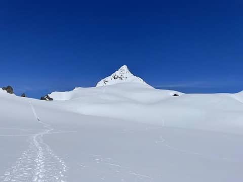 forgot to take a closer picture of the summit pyramid, but it was very snowy with tons of wet loose debris at the bottom with these huge channels that I think had been carved out by the debris 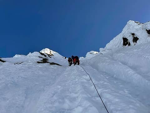 climbing between the channels on the upper pyramid. great snow for kicking steps (or using the steps already kicked in)  summit view! 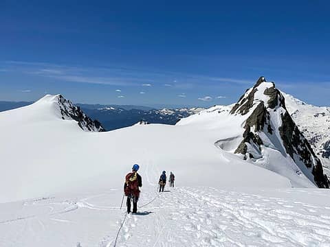 back down the glacier. snow was getting really sloppy at this point and we were postholing mid-shin with each step 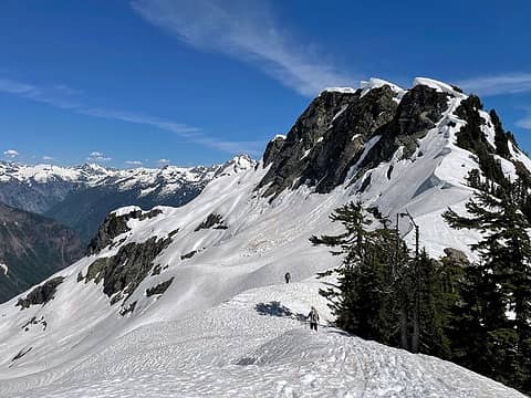 easy hike out on soft snow. tons of new debris between camp and the NCNP boundary that weren't there the day before (particularly on the east-facing slopes)
fourteen410, Now I Fly, jaysway, JimK, awilsondc, RossJames, RichP, zimmertr
fourteen410, Now I Fly, jaysway, JimK, awilsondc, RossJames, RichP, zimmertr |
| Back to top |
|
|
RossJames
Member

Joined: 27 Apr 2020
Posts: 39 | TRs | Pics
Location: Kennewick, WA |
Nice post. We probably went by each other at some point. I like the water melting technique. Heres a little closer shot of Shuksan from the 25th
HikingBex, JimK, RichP, Tom
HikingBex, JimK, RichP, Tom |
| Back to top |
|
|
RichP
Member
Joined: 13 Jul 2006
Posts: 5634 | TRs | Pics
Location: here |
|
RichP
Member
|
Mon Jun 27, 2022 9:04 am |
|
|
Turned off the freeway for the short hike up (down?) to Peoh Point. After hitting a couple of nearby peaks, I walked up from the gate. Bird's eye view of Cle Elum and the valley. Quite a few ORV driving maniacs speeding around blind curves on the drive up. I almost bagged one of them. Duh!
Now I Fly, JimK
Now I Fly, JimK |
| Back to top |
|
|
Opus
Wannabe

Joined: 04 Mar 2006
Posts: 3700 | TRs | Pics
Location: The big rock candy mountain |
|
Opus
Wannabe
|
Mon Jun 27, 2022 9:27 am |
|
|
The Yellow Aster Butte area is still very snowy. Solid snow from about 4500 ft upwards and the tarns are still frozen. Only a few of them beginning to melt through now. I found 2 small melted campsites but otherwise all camping is on snow right now.
resilient, gumby, RossJames, HikingBex, wyattmullen, Now I Fly, half fast, jaysway, JimK, Lightning_bug, awilsondc, zimmertr
resilient, gumby, RossJames, HikingBex, wyattmullen, Now I Fly, half fast, jaysway, JimK, Lightning_bug, awilsondc, zimmertr |
| Back to top |
|
|
HikingBex
Member
Joined: 17 Aug 2020
Posts: 110 | TRs | Pics
|
thanks for this! it was a beautiful day to be up there!
RossJames
RossJames |
| Back to top |
|
|
|
|
You cannot post new topics in this forum
You cannot reply to topics in this forum
You cannot edit your posts in this forum
You cannot delete your posts in this forum
You cannot vote in polls in this forum
|
Disclosure: As an Amazon Associate NWHikers.net earns from qualifying purchases when you use our link(s). |


