| Previous :: Next Topic |
| Author |
Message |
MLHSN
What goes here?????


Joined: 09 Sep 2007
Posts: 1069 | TRs | Pics
Location: Wenatchee |
|
MLHSN
What goes here?????
|
 Mon Jul 21, 2008 6:22 pm |
|
|
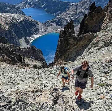
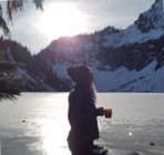
Lake Victoria
length: 4.5 mi. one-way
gain: 3650'
Dan and I stepped off around 6:30 pm on Friday in the hopes of making it to Victoria by dark. The path follows an old fishermen's trail straight up the north side of Mount Cashmere. The trail appears to have once been an official Forest service trail at one point in time judging by the TH sign and signs at the lake as well as a privy near the camping site. However, the trail has long since been abandoned. Much of the area containing the trail was burned badly in 2004 and in some sections little vegetation has returned.
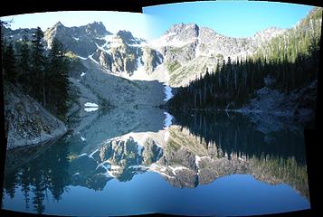 First Autostich, Victoria reflection 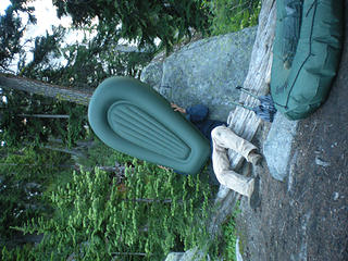 light headed 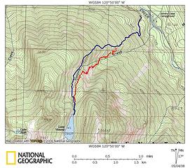 Victoria Map
 Chief Joseph Chief Joseph
Chief Joseph |
| Back to top |
  
|
|
Backpacker Joe
Blind Hiker

Joined: 16 Dec 2001
Posts: 23956 | TRs | Pics
Location: Cle Elum |
Well, how was the fishing?
"If destruction be our lot we must ourselves be its author and finisher. As a nation of freemen we must live through all time or die by suicide."
Abraham Lincoln
"If destruction be our lot we must ourselves be its author and finisher. As a nation of freemen we must live through all time or die by suicide."
Abraham Lincoln
|
| Back to top |
|
|
MLHSN
What goes here?????
Joined: 09 Sep 2007
Posts: 1069 | TRs | Pics
Location: Wenatchee |
|
MLHSN
What goes here?????
|
Mon Jul 21, 2008 8:00 pm |
|
|
biggest Marlin I ever saw....

|
| Back to top |
|
|
Flower Sniffer
Sniffer of flowers

Joined: 12 Jun 2006
Posts: 977 | TRs | Pics
Location: Snohomish, WA |
That's sweet! I used to have one of those Sevlor backpack boats! Well, I still do, but it's got a hole in it from when someone who won't be named tied it to a tree in a wind storm.  Anyway, those pics bring back memories! Thanks! Anyway, those pics bring back memories! Thanks!
If you don't know where you're going, any road will take you there.
If you don't know where you're going, any road will take you there.
|
| Back to top |
|
|
mntsun
Wunderer

Joined: 08 Jul 2007
Posts: 206 | TRs | Pics
Location: Squaresville |
|
mntsun
Wunderer
|
Tue Jul 22, 2008 9:08 am |
|
|
Good work on flotation and avoiding the Cashmere Mozzies. Over the weekend Eightmile Lake was nearly bug free but Lake Caroline up to Windy Pass was one of the worser mozzie bite fests I've experienced.
We did see some successful Lake Caroline fisherman (in the requisite bug netting).
|
| Back to top |
|
|
Ashleynne
Member

Joined: 15 Apr 2024
Posts: 14 | TRs | Pics
|
I dont suppose you will be going back this summer? I might of missed it in the thread but was wanting to know the mileage and elevation gain approximately. 
|
| Back to top |
|
|
MLHSN
What goes here?????
Joined: 09 Sep 2007
Posts: 1069 | TRs | Pics
Location: Wenatchee |
|
MLHSN
What goes here?????
|
Tue Apr 16, 2024 6:48 am |
|
|
Well, this was 16 years ago so my memory fades a bit. About 4-4.5 miles and 3600' gain. Last I went was after a fire and the trail had pretty much disappeared. I've heard through the grapevine that the old footpath has improved with an uptick in traffic.
I don't plan on going back this summer or for a while. Going in for back fusion surgery soon and will be out of action for the summer.
|
| Back to top |
|
|
zimmertr
TJ Zimmerman
Joined: 24 Jun 2018
Posts: 1227 | TRs | Pics
Location: Issaquah |
|
zimmertr
TJ Zimmerman
|
Tue Apr 16, 2024 7:13 pm |
|
|
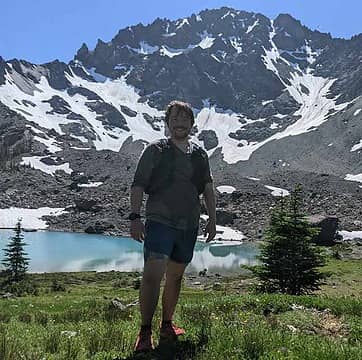
I got 7 miles and 3,563' when I went in 2021. Make sure you look into property ownership before you go. The route wasn't very hard to follow, but the middle section of the climb is very exposed to the sun and there are dozens of down trees from the burn. It's a pretty lake.
EDIT: Removed links to avoid drama. DM me if you want them.
|
| Back to top |
|
|
Ashleynne
Member
Joined: 15 Apr 2024
Posts: 14 | TRs | Pics
|
I dont suppose you have any interest going back and letting me tag along with you? I have so much interest in off trails but would like the company and safety of having another with me!
|
| Back to top |
|
|
zimmertr
TJ Zimmerman
Joined: 24 Jun 2018
Posts: 1227 | TRs | Pics
Location: Issaquah |
|
zimmertr
TJ Zimmerman
|
Tue Apr 16, 2024 7:43 pm |
|
|
Sure, maybe once summer comes. Where do you live approximately? Feel free to DM me, my girlfriend and I are always looking for more hiking/backpacking friends.
For what it's worth though, this is about as easy as route finding gets. You can still find traces of the trail for almost all of it. I remember one spot where the route crossed a talus field that was a little tricky but that's it. I think you would be fine as long as you have the stamina and are able to route find while you're there. (Carry a map/compass or prepare a GPX file and bring a GPS enabled device with downloaded topographic data)
I hyperlinked my Strava activity above, you should be able to harvest my GPX file from it. Also, while you're at it, look up Chikamin Lake and Lake Ida
EDIT: Removed links to avoid drama. DM me if you want them.
|
| Back to top |
|
|
Bootpathguy
Member

Joined: 18 Jun 2015
Posts: 1790 | TRs | Pics
Location: United States |
| zimmertr wrote: | | For what it's worth though, this is about as easy as route finding gets |
I don't agree. Just finding the trailhead is confusing. It's tradition for me to go every cinco de mayo. Every trip I stumble around to locate the route. Bring home ticks every time. Boulder section is hazardous with snow cover. I do agree that it's a really pretty area.
Experience is what'cha get, when you get what'cha don't want
Experience is what'cha get, when you get what'cha don't want
|
| Back to top |
|
|
Worthington
Member
Joined: 23 Jun 2021
Posts: 80 | TRs | Pics
|
It's a free country, but any chance a huge "pretty please" would help convince you to remove your "Lake Eye Duh" tracks and gps trails from the internet and this link?
Please?
|
| Back to top |
|
|
Sculpin
Member

Joined: 23 Apr 2015
Posts: 1384 | TRs | Pics
|
|
Sculpin
Member
|
Wed Apr 17, 2024 8:01 am |
|
|
This TR feels like it's right in the NWHikers sweet spot, a ridiculously difficult route to a really nice place.
Between every two pines is a doorway to the new world. - John Muir
Between every two pines is a doorway to the new world. - John Muir
|
| Back to top |
|
|
zimmertr
TJ Zimmerman
Joined: 24 Jun 2018
Posts: 1227 | TRs | Pics
Location: Issaquah |
|
zimmertr
TJ Zimmerman
|
Wed Apr 17, 2024 8:39 am |
|
|
| Bootpathguy wrote: | | Just finding the trailhead is confusing |
That's fair. I actually recall getting parking information from you here years ago
| Worthington wrote: | | remove your "Lake Eye Duh" tracks and gps trails from the internet |
Sharing route information is safety conscious. There are also plotted trails to the lake on OSM now that show up on Caltopo and all (not that they really exist). There are also six other files here on Peakbagger already.
I edited my comment to break incoming search engine results for you though. (I still think we should have a members only forum index that isn't indexed by Google)
Also: https://en.wikipedia.org/wiki/Streisand_effect
EDIT: Removed links to avoid drama. DM me if you want them. (Now that the Streisand Effect is at max efficacy)
|
| Back to top |
|
|
KascadeFlat
Member
Joined: 06 Jul 2020
Posts: 317 | TRs | Pics
Location: Eating peanut M&Ms under my blue tarp |
I'll throw my hat in the ring for a Lake Victoria trip. My regular trip partner is getting married in August so I will be partner-less in prime time this year. This area has been on my list for a long time.
I can bring my route finding experience, endless patience for navigating burns, and two pack rafts (but someone else has to carry one).
For a good time call: 1-800-SLD-ALDR.
zimmertr, MLHSN, RichP, Tom
For a good time call: 1-800-SLD-ALDR.
zimmertr, MLHSN, RichP, Tom
|
| Back to top |
|
|
|
|


