| Previous :: Next Topic |
| Author |
Message |
Matt
Tea, Earl Grey, Hot


Joined: 30 Jan 2007
Posts: 4307 | TRs | Pics
Location: Shoreline |
|
Matt
Tea, Earl Grey, Hot
|
 Fri Oct 03, 2014 11:30 pm |
|
|
Dates: September 27-28, 2014
Destination: Corteo, Benzarino
Party: Dicey, Matt
Itinerary:
Saturday: Hike to camp at Horsefly Pass. Climb Corteo.
Sunday: Traverse around Corteo to Benzarino. Return to camp and hike out.
Result: Miles of beautifully colored meadow hiking around the edges of the peaks.
Larch Report: Some large trees had turned. Most had not. Thousands of juvenile larches along the way not turned yet. Probably lucky, because even without the full larch color, I could barely keep moving without stopping to admire or photograph the colors.
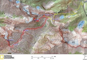 Corteo & Benzarino GPS Track 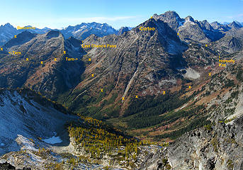 Routes viewed from Frisco Mtn 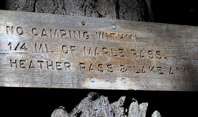 No camping in these places 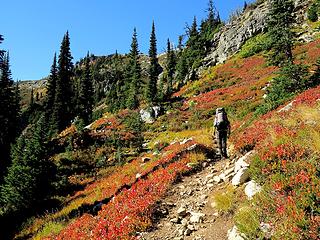 Maple Pass Trail 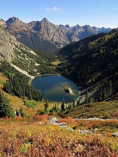 Lake Ann 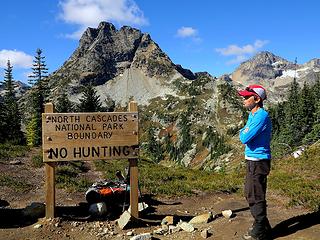 Giant Maple Pass sign that you can see from a mile away 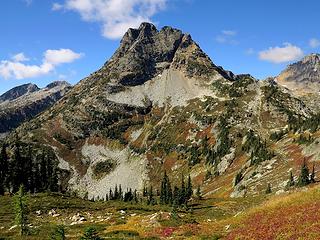 Corteo! 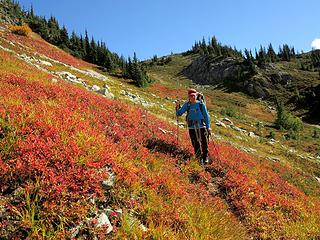 Way trail to Horsefly Pass 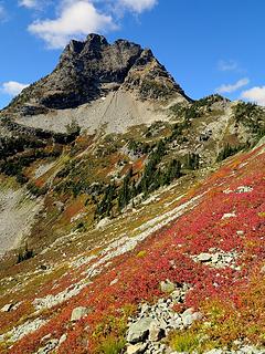 Corteo along the way 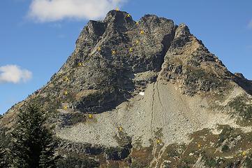 Corteo Route 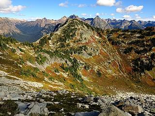 Looking back at Horsefly & Maple Passes on the way up 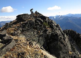 Carla arriving at the summit 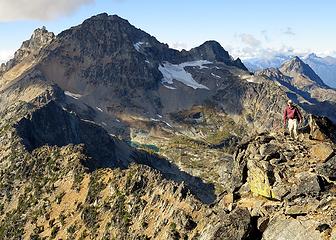 Me on Corteo 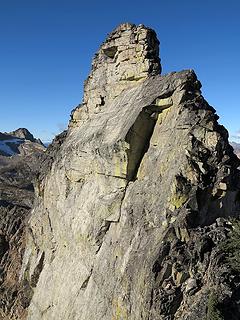 Back side of Corteo 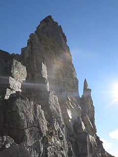 Steep side of the summit block seen from the notch 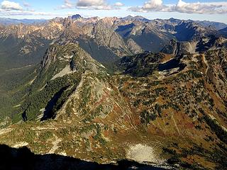 Maple Pass 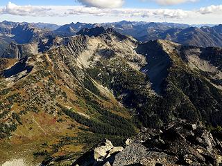 Frisco 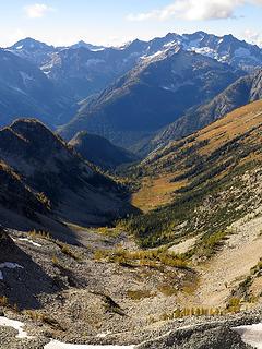 Looking west down Woody Creek 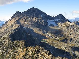 Black Peak 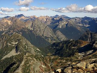 Looking east to Whistler & Washington Pass 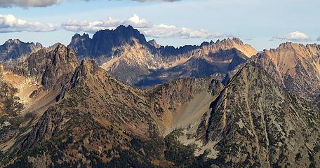 Spiky Silverstar & Snagtooth Ridge 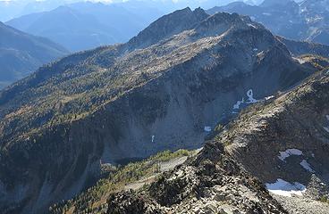 Benzarino in the distance, with the steep valley to cross below Last Chance Pass 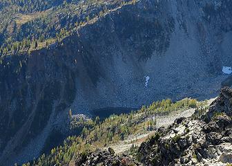 Tarn in the valley, route goes right up the opposite side, but is much less steep than it looks 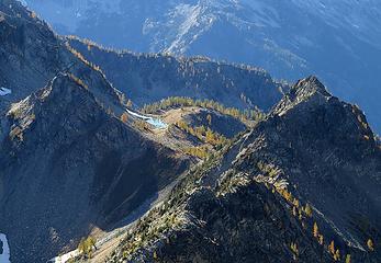 Beautiful tarn on top of Last Chance Pass 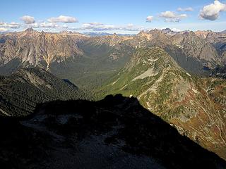 Corteo's square-topped shadow sitting on Horsefly Pass 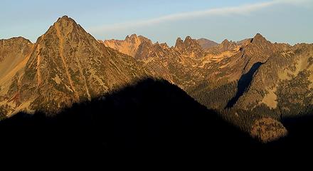 Evening light on Whistler and the Liberty Bell area 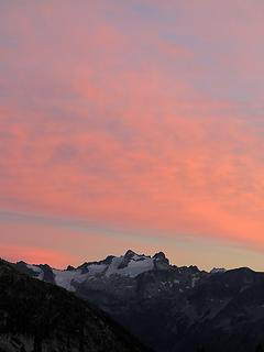 Sunset clouds above McGregor 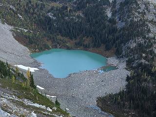 Looking down at Lewis Lake in the twilight 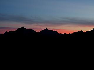 Last light behind Hardy & Golden Horn 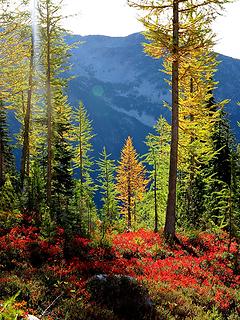 Colors along the way 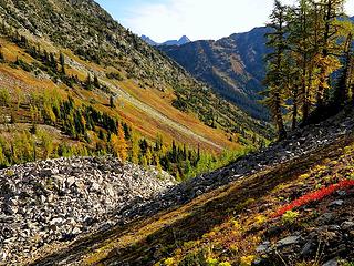 Looking back along the meadows we traversed 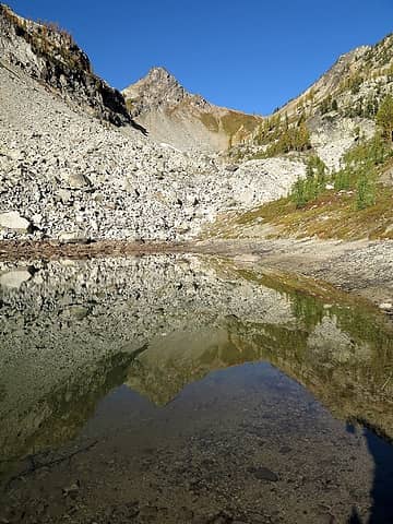 Looking up from Tarn 6250 to Last Chance Pass 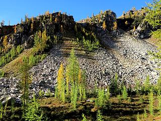 Route out of Tarn 6250 goes up the center of this photo 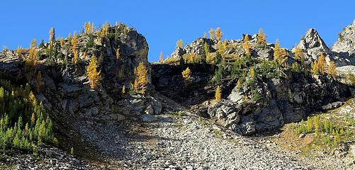 More of the green and gold crest 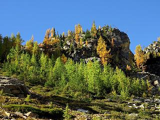 And more of the green and gold crest 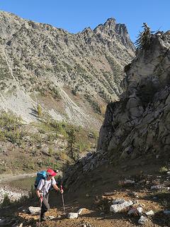 Dicey exiting the exit gully above Tarn 6250 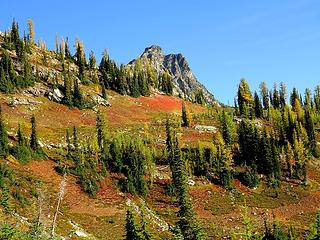 Looking back at the red bench and Corteo 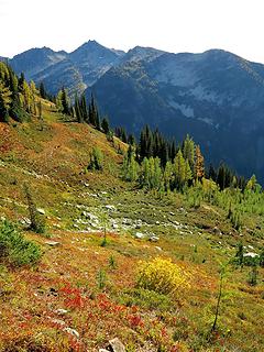 Meadows & Frisco 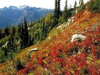 Meadows & McGregor 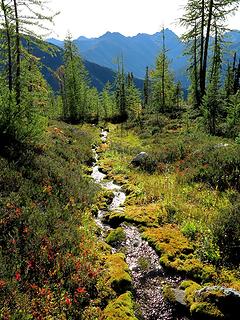 Bright stream 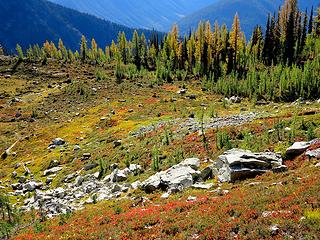 Meadows and rocks 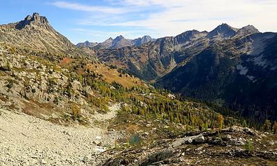 Looking down at Tarn 6350 and the traverse from Corteo 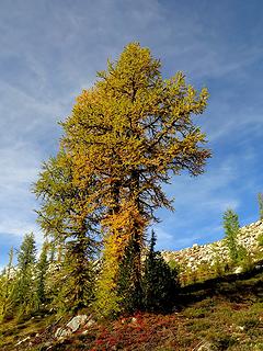 A bigger larch along the way 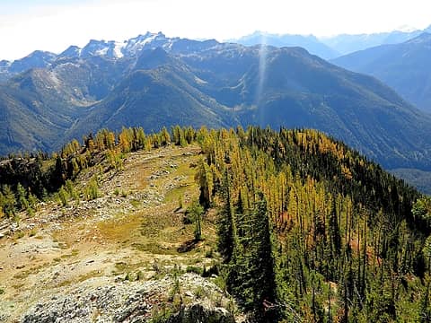 Wide crest of Benzarino's lower south ridge 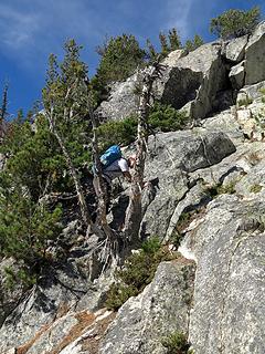 Scrambling on Benzarino south ridge. 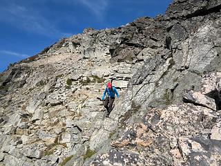 Bypassing the false summit 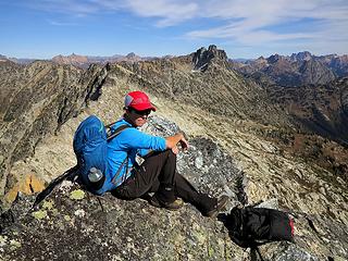 Carly on Benzarino 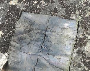 Old register 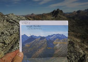 New register 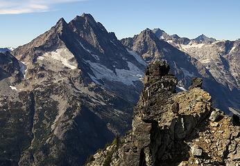 Goode & Stormking 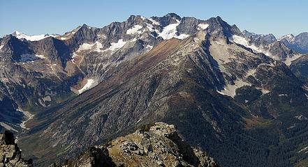 Logan 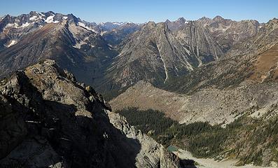 Looking up Fisher Creek to Logan, Natal & Indecision, and Ragged Ridge 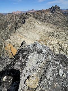 Summit cairn and Benzarino's crest running east to Corteo 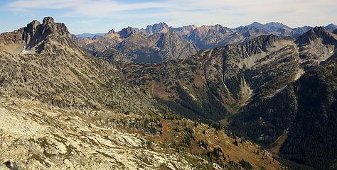 Looking back to Corteo & Maple Pass 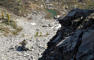 Looking way down at Tarn 6350 note the larches perches high on the rocks and on a boulder 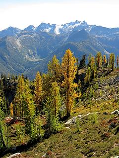 Larches & McGregor 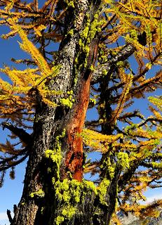 Interesting mix of colors of needs, bark, & lichens 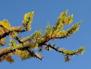 Green & gold needles 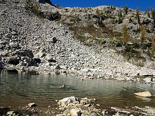 A quick swim in Tarn 6350 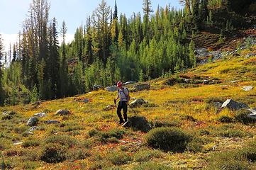 Meadow hiking 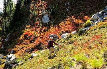 Me hiking through the colors 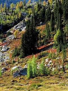 Layers of trees 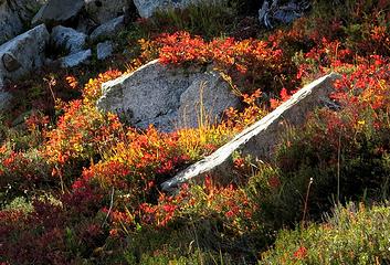 Rocks carpeted with colors 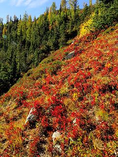 Red! 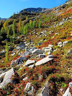 White rocks, red meadow, bright green trees, gray mountain, blue sky 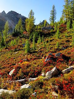 More white, red, gold, green, gray, and blue 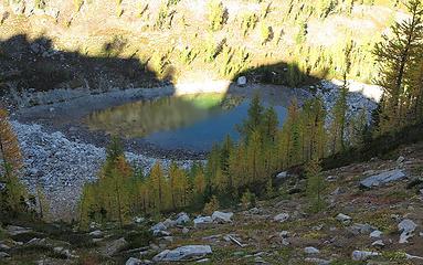 Tarn 6250 dropping into shadow 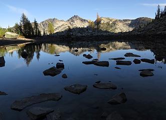 Rocks in the shallow tarn 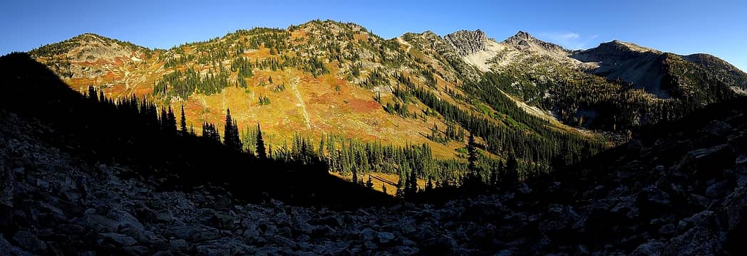 Evening shadows and light across Maple Pass
As beacons mountains burned at evening. J.R.R. Tolkien
As beacons mountains burned at evening. J.R.R. Tolkien
|
| Back to top |
  
|
|
John Morrow
Member

Joined: 03 Apr 2007
Posts: 1526 | TRs | Pics
Location: Roslyn |
Awesome, thanks you two. Looks like Benzarino is another great scramble option in the WA Pass region. Add it to the Stiletto Traverse, Blue Lake Pk (west ridge above lake to east gully) to Pk 7651', Copper-Wallaby, Rainy-Frisco, Hock-Twisp, etc. etc. No one seems to go to Corteo SW Ridge which I thought was another great Cl 3 scramble, probably because it is a circuitous access...good combined with Black Peak. A trip to WA Pass is in order!
| Matt wrote: | White rocks, red meadow, bright green trees, gray mountain, blue sky |
Sums it up perfect!!!
Tell me, what is it you plan to do with your one wild and precious life?-Mary Oliver
A nation that continues year after year to spend more money on military defense than on programs of social uplift is approaching spiritual doom.
― MLK Jr.
Tell me, what is it you plan to do with your one wild and precious life?-Mary Oliver
A nation that continues year after year to spend more money on military defense than on programs of social uplift is approaching spiritual doom.
― MLK Jr.
|
| Back to top |
|
|
Gimpilator
infinity/21M

Joined: 12 Oct 2006
Posts: 1684 | TRs | Pics
Location: Edmonds, WA |
Very cool trip and a fun report too. Thanks! 
|
| Back to top |
|
|
Sadie's Driver
Sadie's Driver

Joined: 24 Apr 2006
Posts: 1763 | TRs | Pics
Location: Welcome Pass |
Lovely pics with all of the splendid fall color - even without much Larch! That area has such vibrant reds in the fall. Nice - thanks.
Four-paw buddy lets me tag along!
Four-paw buddy lets me tag along!
|
| Back to top |
|
|
Stefan
Member

Joined: 17 Dec 2001
Posts: 5091 | TRs | Pics
|
|
Stefan
Member
|
Sat Oct 04, 2014 8:59 pm |
|
|
I don't recall it being that beautiful. Awesome pictures Matt!
|
| Back to top |
|
|
puzzlr
Mid Fork Rocks

Joined: 13 Feb 2007
Posts: 7220 | TRs | Pics
Location: Stuck in the middle |
|
puzzlr
Mid Fork Rocks
|
Sat Oct 04, 2014 10:47 pm |
|
|
Fall is already so far along up there. Beautiful pictures and helpful report.
What does a "matchbox container register" look like?
|
| Back to top |
|
|
Snowdog
Member

Joined: 21 Jul 2006
Posts: 1028 | TRs | Pics
Location: on (& off) the beaten path |
|
Snowdog
Member
|
Sun Oct 05, 2014 9:21 am |
|
|
loverly- good to the last drop!
'we don't have time for a shortcut'
'we don't have time for a shortcut'
|
| Back to top |
|
|
joker
seeker

Joined: 12 Aug 2006
Posts: 7953 | TRs | Pics
Location: state of confusion |
|
joker
seeker
|
Sun Oct 05, 2014 10:53 am |
|
|
Thanks for the very visual report. Looks like some great hiking/scrambling.
| Matt wrote: | | The tea was almost undrinkable, because the water from my new MSR dromedary bag tasted so bad. |
Good to know - my V1 dromedary bag only got one use due to the awful taste. I tried cleaning it, soaking it, etc. and nothing could get rid of that awful flavor. I'm surprised they keep selling it if they haven't been able to fix this.
I suppose the inner plastic liner back must have horrible hormone-screwing chemicals, but I still use my REI Water Sack, a product that they discontinued quite a while back (but I managed to buy a handful of spare lines before the stock was gone...).
At 4 oz for something well north of a gallon, it's a great solution for hauling a night/morning/dayhike's worth of water to a dry camp.
|
| Back to top |
|
|
littlebit
Member

Joined: 23 Jun 2012
Posts: 39 | TRs | Pics
Location: Winthrop WA |
Nice trip report. It was very helpful on our recent climb (9/10-9/11). Since I'm likely to be too lazy to write my own I'll just add a couple of notes.
We've done the traverse from Maple pass twice, once by the high route and once by the low route described in this trip report. The low route is somewhat better although about halfway over we climbed to join the higher route in order to avoid a large swath of slide alder.
We camped at the second tarn at the base of Mt Benzarino. It took us about 5 hours to get there. We camped on a nice, mostly dry mud flat.
I no longer feel comfortable climbing hard class 3 without a rope so we did not go straight up the ridge. Instead we found a gully on the south face that bypasses the 3rd class. We climbed to the notch on the south ridge (it looks like the south coast line of Texas). About 20 ft past the lowest part of the notch there is a west trending ledge. We dropped down a few feet and then up and around the corner. This dumped us into the gully which easily took us just to the top of the 3rd class climbing. The rest was an easy scramble to the summit.
Unfortunately, it was to early in the fall for the amazing fall colors pictured in this trip report. However there was some color starting to show.
This summit gets few visitors. One entry in each year, 2104, 2015 and 2016 (ours).
|
| Back to top |
|
|
Gwen
LO Girl-of-the-Month
Joined: 14 Feb 2010
Posts: 1673 | TRs | Pics
|
|
Gwen
LO Girl-of-the-Month
|
Mon Sep 12, 2016 5:25 pm |
|
|
Dammit littlebit! You got me all excited by dredging up this post with golden larches. Sigh, I guess we still have to wait a couple of weeks. Will they turn early this year?
Tomorrow's not promised to anyone, so be bold, scare yourself, attempt something with no guarantee of success. You'll be amazed at what you can achieve. -Olive McGloin
Tomorrow's not promised to anyone, so be bold, scare yourself, attempt something with no guarantee of success. You'll be amazed at what you can achieve. -Olive McGloin
|
| Back to top |
|
|
iron
Member

Joined: 10 Aug 2008
Posts: 6392 | TRs | Pics
Location: southeast kootenays |
|
iron
Member
|
Mon Sep 12, 2016 5:55 pm |
|
|
| Matt wrote: | Looking way down at Tarn 6350 note the larches perches high on the rocks and on a boulder |
really cool to see the drainage line of the tarn!
this is a wonderful area. thanks for bringing back some memories. i always thought that camping at that tarn in larch season would be truly awesome. guess you'd need to do it in a year that rains a lot just before heading out to fill it back up (but not enough to drop all the larch needles).
| Stefan wrote: | | I don't recall it being that beautiful. Awesome pictures Matt! |
it helps when you look at the scenery instead of only thinking about the summit!  
|
| Back to top |
|
|
Kenji
Member

Joined: 18 May 2010
Posts: 320 | TRs | Pics
Location: Seattle |
|
Kenji
Member
|
Mon Sep 12, 2016 6:36 pm |
|
|
|
| Back to top |
|
|
ShailCaesar!
Member
Joined: 15 Sep 2016
Posts: 5 | TRs | Pics
Location: Westbank |
Looks so different from when I ski toured up to pt 6870 on May 1! Just keeping this post up at the top for reference I might have to go hike there this fall. What an awesome area! Thx!
|
| Back to top |
|
|
tigermn
Member

Joined: 10 Jul 2007
Posts: 9242 | TRs | Pics
Location: There... |
|
tigermn
Member
|
Thu Sep 15, 2016 1:26 pm |
|
|
Wish the weather was going to be better this weekend. I'd head up for the Maple Pass loop. Looks like fall is in full swing.
Beautiful.
|
| Back to top |
|
|
Foist
Sultan of Sweat

Joined: 08 May 2006
Posts: 3974 | TRs | Pics
Location: Back! |
|
Foist
Sultan of Sweat
|
Thu Sep 15, 2016 5:05 pm |
|
|
Do not despair, this trip report is from September 27-28, 2014.
|
| Back to top |
|
|
|
|
You cannot post new topics in this forum
You cannot reply to topics in this forum
You cannot edit your posts in this forum
You cannot delete your posts in this forum
You cannot vote in polls in this forum
|
Disclosure: As an Amazon Associate NWHikers.net earns from qualifying purchases when you use our link(s). |


