| Previous :: Next Topic |
| Author |
Message |
puzzlr
Mid Fork Rocks


Joined: 13 Feb 2007
Posts: 7220 | TRs | Pics
Location: Stuck in the middle |
|
puzzlr
Mid Fork Rocks
|
 Wed Aug 05, 2015 1:51 pm |
|
|
Martin S and I climbed Burntboot via the Middle Fork valley, starting up at the Hardscrabble trailhead. Most years the river crossing is the first difficulty, but this year's low water let us rock-hop across. We came in the night before and slept at the trailhead to get an early start and avoid the heat of the day. On the way in we enjoyed 2 miles of new pavement just laid down this week.
The lower 1500' of the valley was gouged out by the glaciers with steep walls interspersed with cliffs and avalanche chutes. To get through this we followed the Pteropsida route described in Dreisbach's book and by Mike Collins. If you can't cross the river right at Hardscrabble then getting to this route would be tough because of the thick brush on the valley floor - other people have reported having to walk up to 1/2 mile up the trail to find a crossing. But there is a recent big log down that spans the river just below the trailhead that will probably be useable for years. We got to the talus after pushing through some tall brush on the valley floor then climbed it to the base of a cliff visible from the trailhead. There is 80' of open forest for the last bit to the cliff, then it's a brushy traverse left below the cliff until you drop down into the gully. The gully would be horrible with water flowing, but it was dry so we could walk up the scoured and sometimes slabby creek bottom which is almost as good as a (very steep) trail. Huge cliffs tower over the right side of the gully until the top where you can exit left into open forest, but with a steep duffy floor.
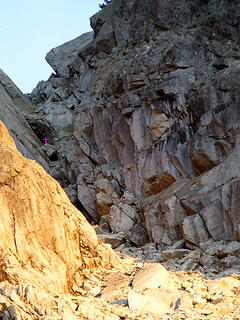
It continues to be steep for a few hundred feet above the gully until at ~4200' the slope eases and the rest of the way is through open forest and talus fields with several options for getting to the summit. We chose to go directly up to the notch just west of the summit, traverse over the peak, then descend the east face. There is easier access to the ridge farther west, but then you need to rap down into the notch. The reason for descending the east face was so I could try to find remains of a 1947 plane crash that went missing until it was discovered by the first ascent group in 1963 (but from a mining company helicopter, not while climbing). The only uncertainty for us was whether the couloir would go without any snow in it. Well, it did, but with a few short 4th class steps spicing up the otherwise 3rd class scrambling with loose rocks. From the notch there is a short 3rd class heather and rock scramble to the summit talus field with some exposure. The 2003 Fay Pullen register was totally soaked so I left a new one and brought it down for archiving.
The summit is only about 1 mile away from the Hardscrabble trailhead, but 3700' higher. We kept moving, and even with an hour on the summit and a short side trip to the plane wreck our RT time from Hardscrabble was 7 hours. But there was still the long segment to and from the Dingford gate.
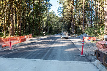 Big Blowout Creek bridge with new pavement starting from the far end of the bridge 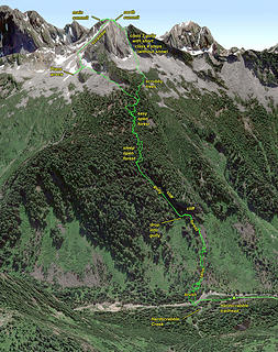 Burntboot route from Hardscrabble trailhead 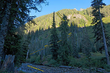 View up from Hardscrabble TH. The north Summit, notch, and the fang west of the notch are visible. The cliff in the foreground is where our route goes. 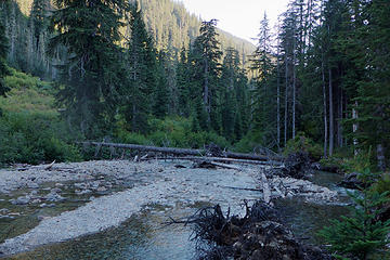 A big tree just downstream of the trailhead that could be a possible river crossing at higher flows 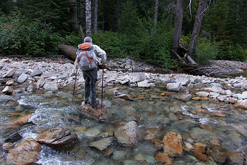 Rock hopping over the Middle Fork river, unusual for this early in summer 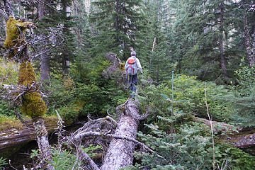 Taking advantage of fallen logs to get through the brush and over the creek to reach the talus field across the river 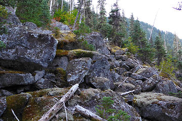 Beginning of the talus slope leading up to the cliff 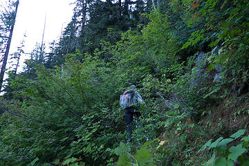 At the base of the cliff we veered left toward a gully. This was the most brushy section and on a steep slope. 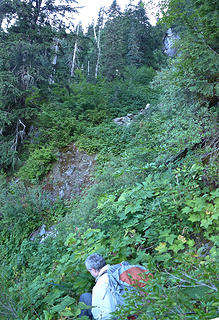 At 3480' we dropped down a 15' step into the gully using veggie belays 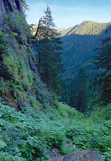 View back down the gully after starting up. The sun is just rising and lighting up the Price-Big Snow ridge across the valley. 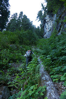 The dry stream bed worked as a relatively less brushy path up the gully. In wetter periods this would be difficult because of slabby rock sections. 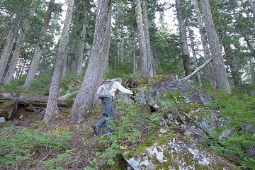 The top of the gully at 4000'. Upon entering the forest here the undergrowth becomes thinner and travel is much easier, but still steep 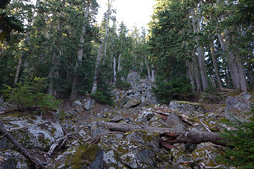 Open forest and blocky talus clearings at ~5000' 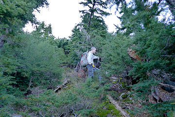 At timberline the trees shrunk to scrub size but it was still easy to find paths through and connect with talus sections. 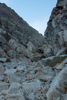 Closer to the gully leading up to the notch. There appear to be big rocks blocking progress. Can we scramble up it? 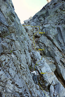 Martin at the first short class 4 step 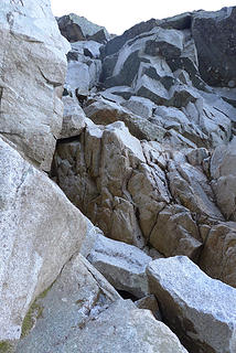 Third class 4 step. It's steep but there were lots of solid foot and hand holds. 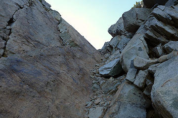 Final scramble to the notch 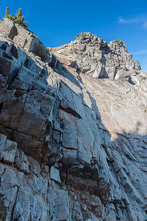 Entering the notch from the ridge would require a rope to descend this cliff safely. I'm glad we chose to come up the gully. 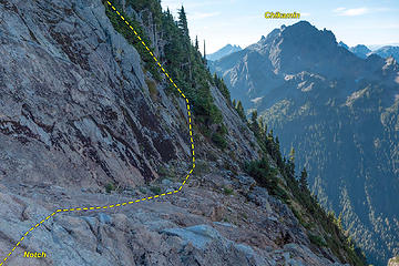 On the south side of the notch a ledge leads to a scramble up and left 300' to the summit. 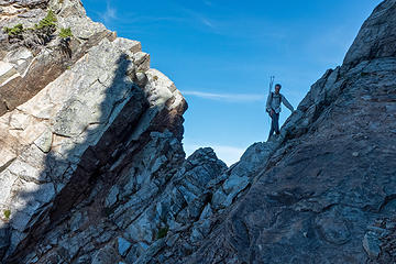 Martin at the notch 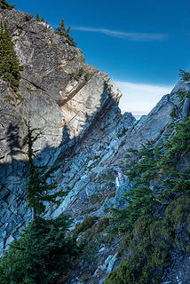 Traversing the ledge from the notch 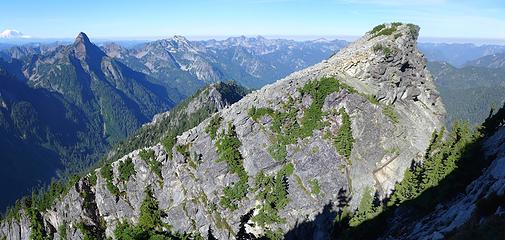 The fang just west of the notch, Point 5481 behind it, Thomson on the left 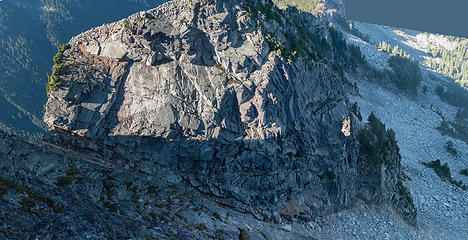 Looking down into the gully we climbed from the north summit 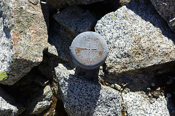 Beyond the north summit I found this survey marker. It says "BCMC Keechelus Peak". My guess is that BCMC stands for Bear Creek Mining Company that sponsored mineral exploration here in the 60s when the peak was first climbed. 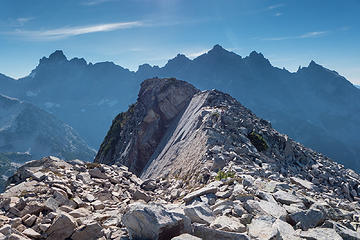 Burntboot south (main) summit 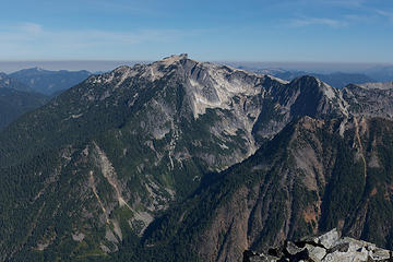 Big Snow from Burntboot 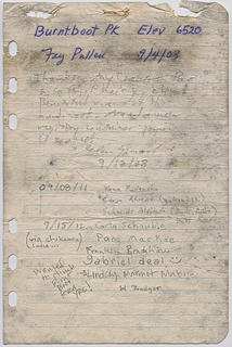 summit register 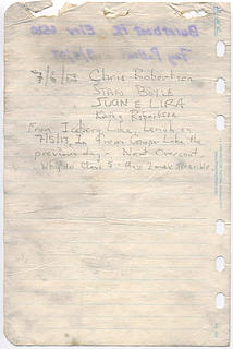 summit register 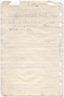 summit register 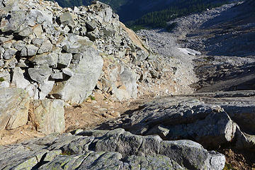 Dreisbach's "class 2" gully up the east face. We chose to descend via the rocky ridge at the top of the picture which worked well. 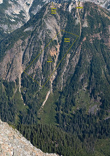 1 label Nellie claim slope on Hardscrabble Peak from Burntboot. The cabin is just a few pixels from this far away. The Nellie Claim is an active mine on private property and entry is not permitted. 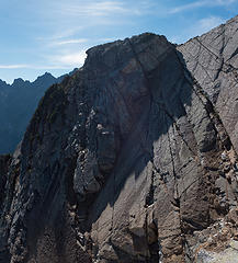 The south (main) Burntboot summit and the huge slab wall below it from the east face 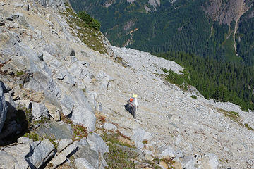 Traversing around to join our ascent route around the corner to the left 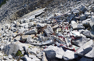 The 1947 plane wreck 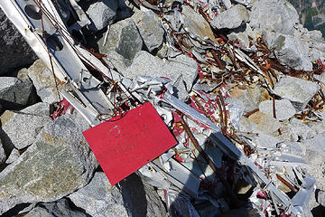 1 label The 1947 plane wreck. Was this red plate used to mark the location? 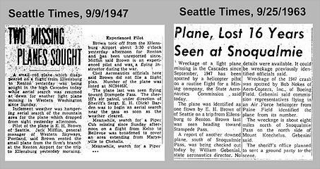 Seattle Times articles related to this plane wreck 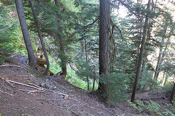 At the top of the gully. The slope is steep here so care must be taken to get into the gully safely. 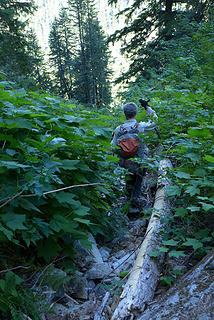 Descending the gully 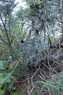 Brush below the cliff after exiting the gully 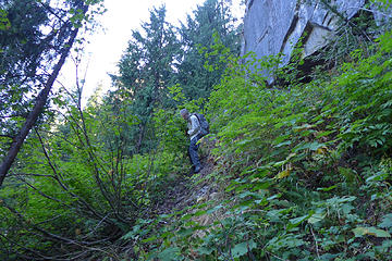 Brush below the cliff after exiting the gully 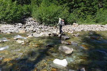 Rock hopping across the Middle Fork at Hardscrabble Creek outlet
|
| Back to top |
  
|
|
yukon222
Member

Joined: 12 Mar 2007
Posts: 1893 | TRs | Pics
|
|
yukon222
Member
|
Wed Aug 05, 2015 2:17 pm |
|
|
Great report! Love the pics and route.
Question - when / why did the "unofficial" peak name change from Keechelus to Burntboot? Obviously burnt boot due to nearby hot springs / creek. Just surprised that the survey marker would reference Keechelus Peak. Burntboot is a "better" choice. :-)
|
| Back to top |
|
|
cartman
Member

Joined: 20 Feb 2007
Posts: 2800 | TRs | Pics
Location: Fremont |
|
cartman
Member
|
Wed Aug 05, 2015 2:18 pm |
|
|
Nice route! Looking at that hillside earlier this year I thought no way would I want to attempt it with all that brush. The rock looks interesting and grippy.
The light at the end of the tunnel grows near...
|
| Back to top |
|
|
puzzlr
Mid Fork Rocks
Joined: 13 Feb 2007
Posts: 7220 | TRs | Pics
Location: Stuck in the middle |
|
puzzlr
Mid Fork Rocks
|
Wed Aug 05, 2015 2:31 pm |
|
|
| yukon222 wrote: | | when / why did the "unofficial" peak name change from Keechelus to Burntboot? |
The name change was in the early 1970's based on the wording in this AAC report. I don't know the reason, but someday I hope to find the records of the naming board. On the other hand, as Martin pointed out when we talked about it, Burntboot is not on the maps so maybe it's not an "official" name. And should there be a space in it or not? I know the name change is not mentioned in the Mountaineers annuals. If belayon still reads these forums maybe he can tell us -- he was one of the two in the first ascent party in 1963.
| Quote: | | 1972 Burnt Boot Peak, North Ridge. Across the middle fork of the Snoqualmie River, two miles southeast of Big Snow Mountain lies P 6480, now officially Burnt Boot Peak. Bill Bucher, Tom Oas and I climbed a new route, the north ridge. From the base of the steepest part of the ridge, three leads of class five on granite, the last being a very sharp crest, led to easier ground. Three leads of class three and four put us on the summit. Only one previous ascent of Burnt Boot Peak was listed in the tin-can register, that of the survey party of 1963.
Don Williamson |
|
| Back to top |
|
|
Hutch
Member
Joined: 18 Jun 2009
Posts: 638 | TRs | Pics
|
|
Hutch
Member
|
Wed Aug 05, 2015 2:33 pm |
|
|
Your trip reports never cease to be inspiring. Not sure I've got the determination for that, but thank you.
|
| Back to top |
|
|
yukon222
Member
Joined: 12 Mar 2007
Posts: 1893 | TRs | Pics
|
|
yukon222
Member
|
Wed Aug 05, 2015 2:58 pm |
|
|
Thanks for the info, Puzzlr.
BTW - the nearby creek currently shows on my USGS 7.5' map as "Burnboot Creek" without any "T". Yet the historical USGS 1885-1915 and 1915-1945 maps show it as "Burnt Boot Creek".
|
| Back to top |
|
|
RichP
Member

Joined: 13 Jul 2006
Posts: 5633 | TRs | Pics
Location: here |
|
RichP
Member
|
Wed Aug 05, 2015 3:27 pm |
|
|
Looks better than I imagined it, puzzlr. Great report.
|
| Back to top |
|
|
Gimpilator
infinity/21M

Joined: 12 Oct 2006
Posts: 1684 | TRs | Pics
Location: Edmonds, WA |
Awesome to see a good detailed route description for this peak. I've wondered about it for a long time. Thanks!!!
|
| Back to top |
|
|
Stefan
Member

Joined: 17 Dec 2001
Posts: 5091 | TRs | Pics
|
|
Stefan
Member
|
Wed Aug 05, 2015 4:48 pm |
|
|
|
| Back to top |
|
|
Stefan-K
Member

Joined: 10 Aug 2009
Posts: 522 | TRs | Pics
Location: seattle |
|
Stefan-K
Member
|
Wed Aug 05, 2015 4:52 pm |
|
|
awesome! love this pic:
...pure cascadia
I went up that couloir last October. Some of those boulders in there, even small bus sized ones, felt like they could easily be re-arranged by another winters season... Here's what it looked like -
 Burnt Boot's NW gully with figure for scale 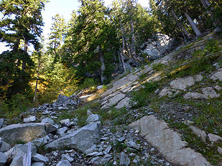 141004_MFkS-BB_13
|
| Back to top |
|
|
Mike Collins
Member
Joined: 18 Dec 2001
Posts: 3095 | TRs | Pics
|
So I am curious. Was my trip report of any help to you reaching the top?
|
| Back to top |
|
|
neek
Member

Joined: 12 Sep 2011
Posts: 2335 | TRs | Pics
Location: Seattle, WA |
|
neek
Member
|
Wed Aug 05, 2015 6:40 pm |
|
|
Neat. That class 4 section looks fun.
|
| Back to top |
|
|
puzzlr
Mid Fork Rocks
Joined: 13 Feb 2007
Posts: 7220 | TRs | Pics
Location: Stuck in the middle |
|
puzzlr
Mid Fork Rocks
|
Wed Aug 05, 2015 10:22 pm |
|
|
| Mike Collins wrote: | | Was my trip report of any help to you reaching the top? |
It was very helpful with specifics about getting up through the gully. As you know, Dreisbach's instructions are vague and the sketch maps are not much help!
But Mike, in your WTA report I think you misplaced what you called Point 5841. The "fang" on the other side of the notch by the summit is at least 6400'. Point 5841 is a ways down the SW ridge. And while it may also be necessary to rap off Point 5841, I don't think that's what you meant.
| Quote: | | Do not attempt to follow the ridge from the Goldmyer Hot Springs unless prepared to rappel into the gully between point 5,841 and the summit. It cannot be done without rope. |
Stefan K re "went looker's right at the first cliff, crossed the avi gully and went up that wooded rib" -- I looked at that as a route option as well, but chose to go with a the gully because there were two accounts that described it. It's good to know that would work as well, maybe better if water was flowing down the gully.
|
| Back to top |
|
|
Mike Collins
Member
Joined: 18 Dec 2001
Posts: 3095 | TRs | Pics
|
| puzzlr wrote: | | But Mike, in your WTA report I think you misplaced what you called Point 5841. |
You are undoubtedly correct. The report with WTA cannot be amended as it was written a number of years ago. With more recent WTA reports I can change the text.
|
| Back to top |
|
|
raising3hikers
Member
Joined: 21 Sep 2007
Posts: 2344 | TRs | Pics
Location: Edmonds, Wa |
good luck on your final 5! thanks for sharing your report on a rarely visited summit
|
| Back to top |
|
|
|
|


