| Previous :: Next Topic |
| Author |
Message |
williswall
poser


Joined: 30 Sep 2007
Posts: 1966 | TRs | Pics
Location: Redmond |
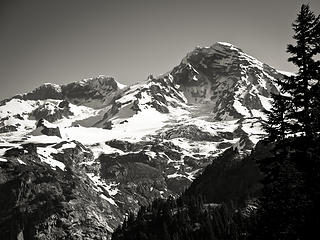
I've been wanting to explore this divide for a few years so finally got to it. Weather of late has been an impediment to some of my plans and originally this was to be a two day trip where I hit the Success Divide on day one then forge up the Puyallup Cleaver on day two. However, one can see from the photos that despite an overall good day weather wise, the clouds covering Rainier were hovering around the 8000 foot level, and since the following day's forecast called for increasing clouds and eventually rain, I decided to bag day two and save that for a pristine day, if it turns up when I am not working.
This is a straight forward hike up to the base of Pyramid Peak, but I found skirting around to acquire the divide was slightly complicated, with myriad tiny cliff bands and, with the exception of one tiny stretch, nary a hint at a trail or an indication that someone has been there before you. Of course this is what makes this hike special, in that very few people come here. Once I finally found a way down to the divide after wandering too far left, travel was not especially pleasant. Loose rock and scree set the tone once above some grassy areas, and some of it is downright nasty. Probably the nastiest part was the final ridge scramble to my high point at 7800 feet, where I was really showing my age. Step, slide, huff puff, repeat. Continuing above this point was not necessary as the views I was seeking were available right at this level and the clouds were lingering slightly above me. In this case, unlike say Mt. Ruth where the glaciers are far below, it seems like you can reach out and touch the South Tahoma Glacier, and my vantage point allowed close up looks at the seracs and interesting morphology of the ice as it spilled over a steep grade. Despite no views upward to the mountain proper, the views west and south were fantastic, even being able to pick out the Tahoma Creek suspension bridge down the gully of the origins of Tahoma Creek. Although fall colors were sparse with areas like Indian Henrys looking winterlike, what patches I did see were vibrant and amazing....I just love hiking in the fall. This round trip worked out to be 22 miles with 5400 feet of elevation gain/loss.
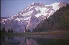
 1. Alder Lake  2. Alder Lake 2  3. Alder Lake 3  4. Alder Lake 4 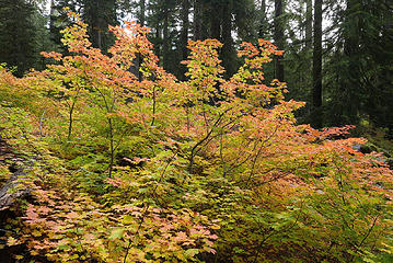 5. Fall Color 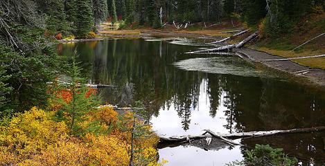 6. tarn below Indian Henrys 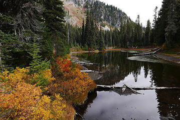 7. fall colors on tarn below Indian Henrys 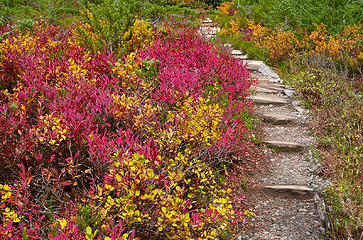 8. fall on the Wonderland 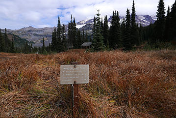 9. Indian Henrys ready for winter 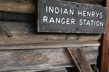 10. Jeff sucks 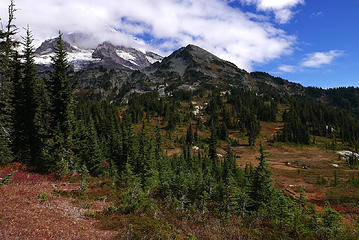 11. Pyramid Peak, Success divide left 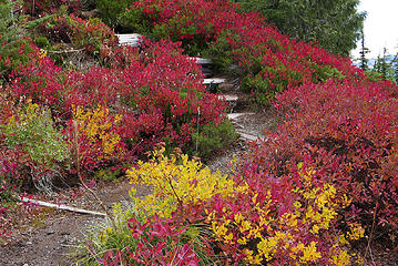 12. fall colors in Pyramid Park 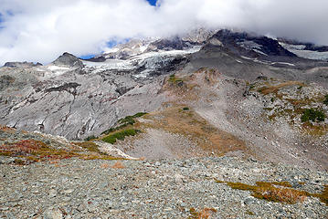 13. Success Divide, S.Tahoma Glacier left 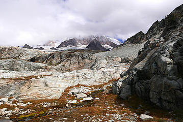 13. terrain skirting Pyramid Peak, Success cleaver center 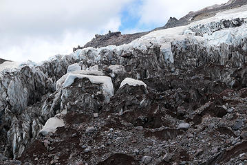 14. S. Tahoma glacier up close 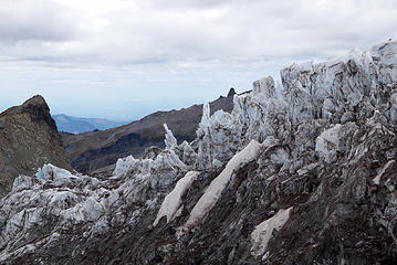 15. S. Tahoma Glacier, Glacier Island left 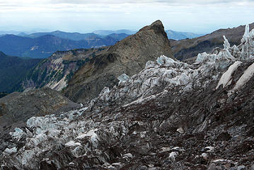 16. Glacier Island 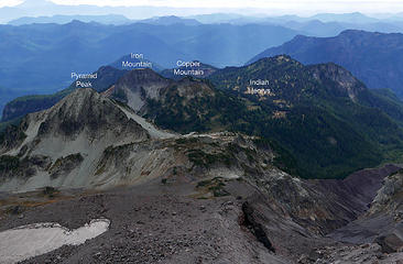 16. the view 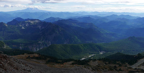 17. Adams and layers 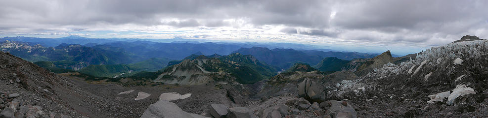 18. pano from 7800' 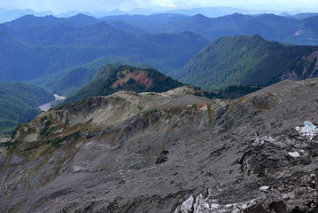 19. Glacier Island below prominence 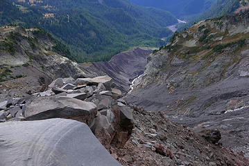 20. gnarly terrain 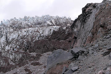 22. S. Tahoma Glacier up close and personal 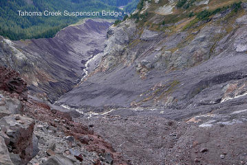 23. Tahoma Creek origin 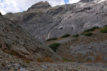 24. snout of the S. Tahoma Glacier 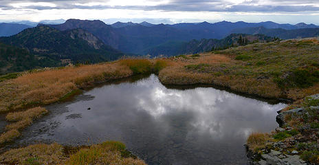 24. tarn below Pyramid Peak 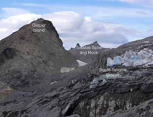 21. points of interest 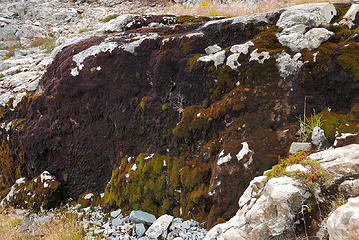 25. dripping moss wall 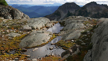 26. Iron and Copper Mountains right 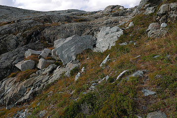 26. not the Enchantments 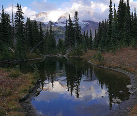 27. Mirror Lakes 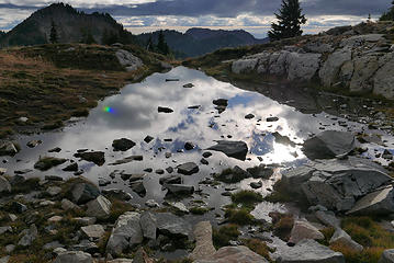 27. reflecting tarn 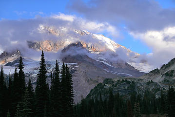 29. Success Divide 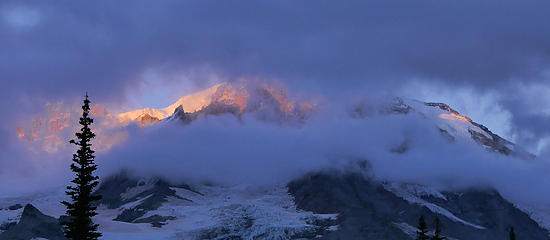 30. peekaboo sunset 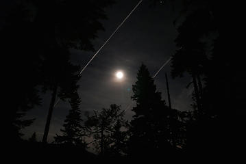 31. moon and contrails  32. parting shot 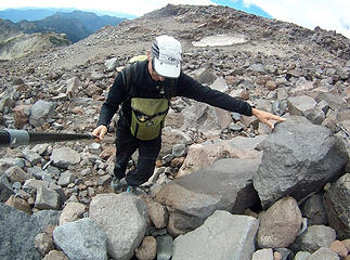 negotiating rocks 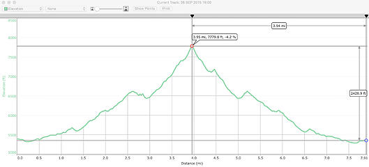 Success Divide elevation profile 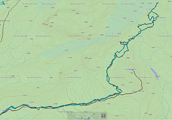 Success Divide Ground Track 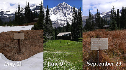 Indian Henrys 3 season
I desire medium danger
williswall.com
 wallorcrawl, jaysway, zimmertr, Now I Fly wallorcrawl, jaysway, zimmertr, Now I Fly
I desire medium danger
williswall.com
wallorcrawl, jaysway, zimmertr, Now I Fly
|
| Back to top |
  
|
|
Distel32
Member

Joined: 03 Jun 2014
Posts: 961 | TRs | Pics
Location: Edmonds, WA |
|
Distel32
Member
|
 Thu Sep 24, 2015 3:43 pm |
|
|
|
| Back to top |
|
|
puzzlr
Mid Fork Rocks

Joined: 13 Feb 2007
Posts: 7220 | TRs | Pics
Location: Stuck in the middle |
|
puzzlr
Mid Fork Rocks
|
Thu Sep 24, 2015 4:34 pm |
|
|
| williswall wrote: | 23. Tahoma Creek origin |
Love that view down the path where the glacier used to be. Isn't this where the recent glacial outburst went down?
|
| Back to top |
|
|
williswall
poser
Joined: 30 Sep 2007
Posts: 1966 | TRs | Pics
Location: Redmond |
| puzzlr wrote: | | williswall wrote: | 23. Tahoma Creek origin |
Love that view down the path where the glacier used to be. Isn't this where the recent glacial outburst went down? |
Possible, but this is the smaller glacier on the right side of Glacier Island. The flood could have originated in the larger Tahoma Glacier which feeds on the other side of Glacier Island. This is a view of the Tahoma Glacier looking towards Success Divide, you can see one lobe of the Tahoma passes skiers left of Emerald Ridge, thereby feeding Tahoma Creek, and the other lobe passes Emerald Ridge skiers right, feeding the South Puyallup River.
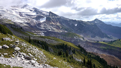 Tahoma Glacier view, Glacier Island
|
| Back to top |
|
|
Magellan
Brutally Handsome

Joined: 26 Jul 2006
Posts: 13116 | TRs | Pics
Location: Inexorable descent |
|
Magellan
Brutally Handsome
|
Thu Sep 24, 2015 8:30 pm |
|
|
Great story and exploration.  I've wanted to climb this ridge since I figured out that one doesn't have to cross a glacier to summit. Perhaps some snow would be helpful. I've wanted to climb this ridge since I figured out that one doesn't have to cross a glacier to summit. Perhaps some snow would be helpful.
|
| Back to top |
|
|
Bernardo
Member

Joined: 08 Feb 2010
Posts: 2174 | TRs | Pics
Location: out and about in the world |
|
Bernardo
Member
|
Thu Sep 24, 2015 9:12 pm |
|
|
Nice trip. Thanks for posting.
|
| Back to top |
|
|
silence
Member

Joined: 25 Apr 2005
Posts: 4420 | TRs | Pics
|
|
silence
Member
|
Fri Sep 25, 2015 9:07 am |
|
|
There's actually a pretty obvious climber's path that traverses around Pyramid. Been on it twice. We were up there early season this year with some hard snow still lingering, and without ice axes or crampons we thought it was too dicey for us because the creek below was running strong. However, yes, it's a non-technical climb to the summit. We talked with a climber (we were both on our way out) who did it in 1 nite, 2 days.
PHOTOS
FILMS
Keep a good head and always carry a light bulb. Bob Dylan
Now I Fly
PHOTOS
FILMS
Keep a good head and always carry a light bulb. Bob Dylan
Now I Fly
|
| Back to top |
|
|
Jetlag
Member
Joined: 17 Aug 2010
Posts: 1410 | TRs | Pics
|
|
Jetlag
Member
|
Fri Sep 25, 2015 11:59 am |
|
|
Great TR and photos!
This is the view I see distantly from my house. After the two glacial outbursts, I went up to MRNP to hear the glacier scientists discuss the events, finding that both DID originate at the shrinking South Tahoma terminus. The second outburst was larger, but no one was there to shoot a video of it.
Magellan, I do NOT recommend the Success Cleaver route, unless you attempt it after avalanche danger has passed and before all that dangerous loose rock surfaces. Even more than the glacier-less north ridge on Adams, the route has a very short climbing window. I would be happy to accompany you to the summit on a better route.
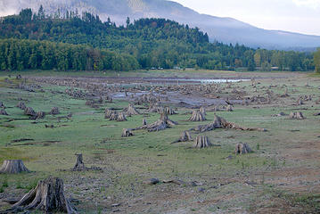
Also, hoping for more rain to fill Alder Lake soon. Reps from the dams, the tribe and WSFW meet every week to adjust the water level. Tacoma City Light just raised the dam's outflow from 550 cubic feet per second to 750 CFS so that the lower Nisqually weir could continue to separate wild Chinook from hatchery fish.
|
| Back to top |
|
|
williswall
poser
Joined: 30 Sep 2007
Posts: 1966 | TRs | Pics
Location: Redmond |
| silence wrote: | | There's actually a pretty obvious climber's path that traverses around Pyramid......However, yes, it's a non-technical climb to the summit. We talked with a climber (we were both on our way out) who did it in 1 nite, 2 days. |
Guess it wasn't so obvious to me, and describing this as a non technical climb is perhaps a bit of an understatement. The route description above 9600' describes very exposed traverses with no way to place protection and generally some pretty nasty conditions. Stats show this climb is mostly done early season with snow cover. Of course, I'm assuming you have not climbed this route....if you have then more power to ya.
|
| Back to top |
|
|
silence
Member
Joined: 25 Apr 2005
Posts: 4420 | TRs | Pics
|
|
silence
Member
|
Fri Sep 25, 2015 1:15 pm |
|
|
It's a grade II climb, but still I thought it was risky doing it solo. He climbed Jun 5 and 6 this year and said it was pretty straightforward, except for some rock fall. Yes agreed, according to Gauthier there is quite a bit of exposure.
Shot on the 6th while on our way out
 Mount Rainier
PHOTOS
FILMS
Keep a good head and always carry a light bulb. Bob Dylan
PHOTOS
FILMS
Keep a good head and always carry a light bulb. Bob Dylan
|
| Back to top |
|
|
Hikingqueen
Member

Joined: 12 Nov 2007
Posts: 2946 | TRs | Pics
|
Great Pics! I know that Jeff! He's a real SOB, used to work for the MRNP and does that *HIT! He also has JEFF ROCKS tattoo on his nuckles in case he forgets how cool he is?  He also carved Snow Pounders into that building somewhere, did you see that? He took pic and posted it on FB years ago! I was SO PISSED when i saw it! He also carved Snow Pounders into that building somewhere, did you see that? He took pic and posted it on FB years ago! I was SO PISSED when i saw it! 
|
| Back to top |
|
|
Popcorn
Member
Joined: 20 Aug 2008
Posts: 151 | TRs | Pics
Location: Another Place |
|
Popcorn
Member
|
Wed Sep 30, 2015 12:01 pm |
|
|
13. terrain skirting Pyramid Peak, Success cleaver center
|
| Back to top |
|
|
Now I Fly
Member
Joined: 07 Jun 2018
Posts: 464 | TRs | Pics
|
Great report! Thanks for writing it!
Think I'll attempt it tomorrow (I have three days)!
Can't wait to try anyways!
|
| Back to top |
|
|
Kascadia
Member
Joined: 03 Feb 2014
Posts: 650 | TRs | Pics
|
|
Kascadia
Member
|
Tue Sep 20, 2022 7:47 pm |
|
|
Nice TR and photos! Had a spectacular ON camp on a ledge at ~10,000 feet on Success Cleaver several decades ago. If one continues up, I would suggest a helmet, it is an exceedingly large pile of dookie.....
It is as though I had read a divine text, written into the world itself, not with letters but rather with essential objects, saying:
Man, stretch thy reason hither, so thou mayest comprehend these things. Johannes Kepler
Now I Fly
It is as though I had read a divine text, written into the world itself, not with letters but rather with essential objects, saying:
Man, stretch thy reason hither, so thou mayest comprehend these things. Johannes Kepler
Now I Fly
|
| Back to top |
|
|
Bruce Albert
Member
Joined: 01 Sep 2007
Posts: 160 | TRs | Pics
|
| williswall wrote: | Indian Henrys 3 season |
Permit me to add a winter view to complete your excellent three season tryptich. This was Thanksgiving, 1975.
With respect to "Jeff" and his transgressions, the surfaces of wooden backcountry structures have long been thickly covered with the names, dates, and anecdotes of those who have come before. At some point that which might be originally condemned as vandalism becomes, like it or not, part of a historical archive. In this case I agree Jeff might reasonably have chosen a more discreet slate for his effort.
In June, 1969 two high school friends and I did a one-week ski trip from White River to Box Canyon on the Cowlitz. After several days of fine weather and excellent skiing we became lost in thick fog on the exit from Indian Bar and spent an entire day bushwhacking with ginormous packs down Nickel Creek to the west of the trail. With absolutely no inkling of where we were or what lay before us, we dutifully slogged down valley, spending much of that time singing a song made up from an inscription on the walls of the Indian Bar shelter which went in part:
"Walter V Kromoga
Great Falls, Montana
August 7, 1940"
Wouldn't have been the same without Walter...
|
| Back to top |
|
|
|
|
You cannot post new topics in this forum
You cannot reply to topics in this forum
You cannot edit your posts in this forum
You cannot delete your posts in this forum
You cannot vote in polls in this forum
|
Disclosure: As an Amazon Associate NWHikers.net earns from qualifying purchases when you use our link(s). |


