| Previous :: Next Topic |
| Author |
Message |
RichP
Member


Joined: 13 Jul 2006
Posts: 5634 | TRs | Pics
Location: here |
|
RichP
Member
|
 Wed Oct 21, 2015 1:21 pm |
|
|
I saw this thread inquiring about a trail between Captain Point and Johnson Ridge.
https://www.nwhikers.net/forums/viewtopic.php?t=8018676
My curiosity was piqued. Since I was planning a hike in the area anyway, I decided to check it out.
The hike along Johnson Ridge has been covered in several trip reports already, so I'll focus on the hike out to Captain Point from there.
Once on Scorpion Mtn, the highpoint of Johnson Ridge, follow the trail down toward Joan Lake which skirts the edge a large, flattish meadow. Hike southward down the meadow to it's eastern edge to where the ridge narrows and look for some tread that enters the forest.
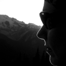
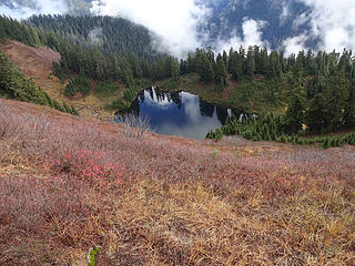 Joan Lake while ascending the last bit to Scorpion Mtn. 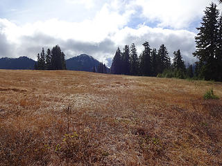 1 label Meadow just below Scorpion Mtn. 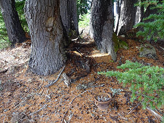 The first signs of the trail from Scorpion to Captain Point were this blaze and old pot. 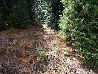 Walking to the east side of the meadow where the ridge narrows we found some tread. 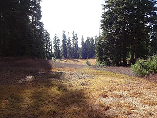 Soon one arrives to a second meadow. No sign of trail while crossing, but it soon picks up on the other side. 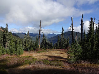 Typical terrain along the ridge between Scorpion Mtn and Captain Point. 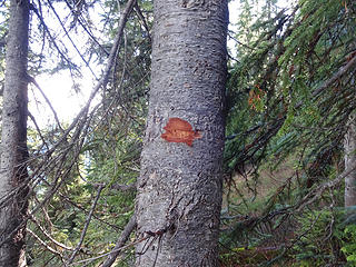 Some newer blazes appear from time to time. 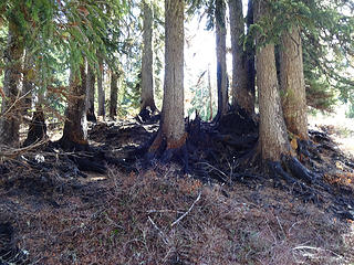 A small burn that was contained by surrounding meadows. 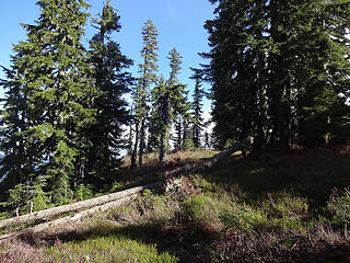 The trail follows benches when near Captain Point. 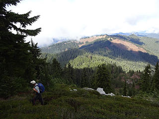 We left the trail at a basin and headed up the north ridge to Captain Point. Scorpion Mtn, Johnson Ridge and much of our route is visible from here. 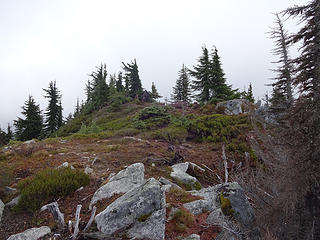 Almost to Captain Point. 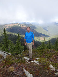 Captain Point 5728.' 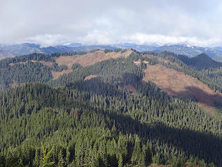 2 labels The trail drops off the ridge before an intermediate point (5133) and traverses east to the basin below Captain Point. 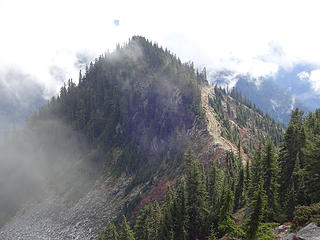 Another point of Captain Point that looks about the same height. A logging road reaches to the saddle between the two. 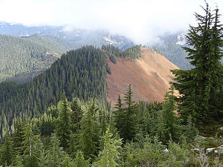 A lower peak below Captain Point. Windy Mtn? 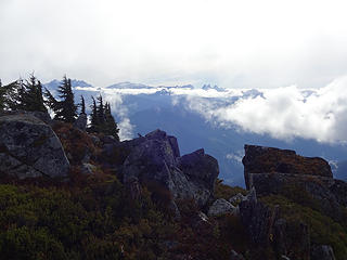 Views north from Captain Point. 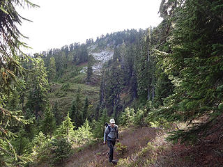 Back in the basin below Captain Point. The east ridge in the rear looks like it would go as well. 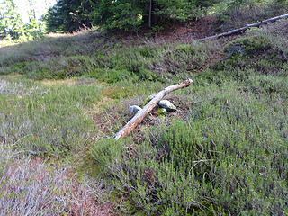 A large cairn. 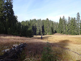 back in the second meadow before ascending back to Johnson Ridge and Scorpion. 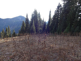 1 label The eastern edge of the first meadow below Scorpion where the trail becomes visible. 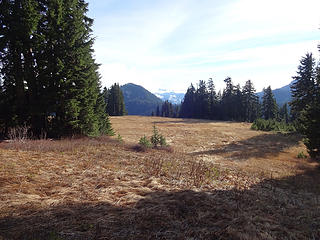 2 labels Looking back across the meadow from the trail that drops to Joan Lake from Johnson Ridge. 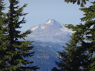 A peak of Glacier from Scorpion Mtn. 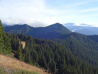 2 labels A view of the ridge between Scorpion Mtn and Captain Point. the small bump in the middle is Point 5133. 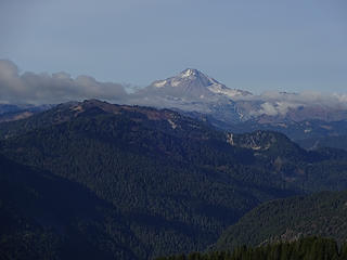 1 label Glacier from Johnson Ridge Trail.
|
| Back to top |
  
|
|
Steve Erickson
Member

Joined: 13 Jun 2005
Posts: 210 | TRs | Pics
Location: Next door to my neighbors |
It has been awhile but I have hiked this trail starting from the logging road you mentioned, up to Captains Point and then down into the basin. As you come into the basin from Captains Point on your way back did you see any trail signage? From memory it was right at the forest edge as the basin starts to level out. That is a very beautiful area and it is sad that the logging road is now closed and not accessible any longer.
|
| Back to top |
|
|
RichP
Member
Joined: 13 Jul 2006
Posts: 5634 | TRs | Pics
Location: here |
|
RichP
Member
|
Wed Oct 21, 2015 1:54 pm |
|
|
| Steve Erickson wrote: | | As you come into the basin from Captains Point on your way back did you see any trail signage? |
I didn't see the signs, but others have mentioned them as well. I looked for them but we may have left the basin before their location to ascend Captain Point.
|
| Back to top |
|
|
Joey
verrry senior member

Joined: 05 Jun 2005
Posts: 2797 | TRs | Pics
Location: Redmond |
|
Joey
verrry senior member
|
Wed Oct 21, 2015 5:45 pm |
|
|
The sign I mentioned in the other thread is at a saddle on the ridge just north of the Captain Point 'basin'.
|
| Back to top |
|
|
Nancyann
Member
Joined: 28 Jul 2013
Posts: 2318 | TRs | Pics
Location: Sultan Basin |
|
Nancyann
Member
|
Wed Oct 21, 2015 6:41 pm |
|
|
Thanks for the great trip report, Rich P..it sounds like you guys had a fun day!
This is a fun area to explore, with lots of potential. 
|
| Back to top |
|
|
Redwic
Unlisted Free Agent

Joined: 23 Feb 2009
Posts: 3292 | TRs | Pics
Location: Going to the Prom(inence) |
|
Redwic
Unlisted Free Agent
|
Wed Oct 21, 2015 8:18 pm |
|
|
Nice report! I need to check out that trail, sometime.
From Johnson Ridge, in addition to the trail leading to Joan Lake I also recall seeing a different trail veering southward from just before (west of) Scorpion Mountain. Does that lead to Fernow Pot Holes?
60 pounds lighter but not 60 points brighter.
60 pounds lighter but not 60 points brighter.
|
| Back to top |
|
|
RichP
Member
Joined: 13 Jul 2006
Posts: 5634 | TRs | Pics
Location: here |
|
RichP
Member
|
Wed Oct 21, 2015 8:19 pm |
|
|
| Redwic wrote: | | in addition to the trail leading to Joan Lake I also recall seeing a different trail veering southward from just before (west of) Scorpion Mountain. Does that lead to Fernow Pot Holes? |
I saw that trail as well. I have no idea where it goes, but maybe someone else does. I'm curious too.
I wish I had taken a pic of it for reference.
|
| Back to top |
|
|
Steve Erickson
Member
Joined: 13 Jun 2005
Posts: 210 | TRs | Pics
Location: Next door to my neighbors |
I am not sure if that other trail off Johnson Ridge you are talking about would lead to Mt. Fernow Potholes. The way I get into the Potholes is not off of the Johnson Ridge Trail to Lake Joan.
|
| Back to top |
|
|
Snowdog
Member

Joined: 21 Jul 2006
Posts: 1028 | TRs | Pics
Location: on (& off) the beaten path |
|
Snowdog
Member
|
Thu Oct 22, 2015 10:18 am |
|
|
Nice extension of Johnson Ridge! I like that trail, not as heavily used as others in the area.
'we don't have time for a shortcut'
'we don't have time for a shortcut'
|
| Back to top |
|
|
puzzlr
Mid Fork Rocks

Joined: 13 Feb 2007
Posts: 7220 | TRs | Pics
Location: Stuck in the middle |
|
puzzlr
Mid Fork Rocks
|
Thu Oct 22, 2015 1:41 pm |
|
|
Nice report about a fading trail. That pot looks really heavy duty for camping  . At one time this must have been a favorite route for hunters or someone that enjoyed being in the back country. . At one time this must have been a favorite route for hunters or someone that enjoyed being in the back country.
|
| Back to top |
|
|
Gwen
LO Girl-of-the-Month
Joined: 14 Feb 2010
Posts: 1673 | TRs | Pics
|
|
Gwen
LO Girl-of-the-Month
|
Thu Oct 22, 2015 2:58 pm |
|
|
We looked and looked for that tread back in July but couldn't find it. Nice work!
The split on Johnson just west of Scorpion is just a bootpath off the main trail that also goes to the summit (bootpath stays on the ridge top, main trail goes right and sidehills through the meadows before reaching the summit/Joan jct).
Tomorrow's not promised to anyone, so be bold, scare yourself, attempt something with no guarantee of success. You'll be amazed at what you can achieve. -Olive McGloin
Tomorrow's not promised to anyone, so be bold, scare yourself, attempt something with no guarantee of success. You'll be amazed at what you can achieve. -Olive McGloin
|
| Back to top |
|
|
RichP
Member
Joined: 13 Jul 2006
Posts: 5634 | TRs | Pics
Location: here |
|
RichP
Member
|
Thu Oct 22, 2015 4:20 pm |
|
|
| Gwen wrote: | | The split on Johnson just west of Scorpion is just a bootpath off the main trail that also goes to the summit (bootpath stays on the ridge top, main trail goes right and sidehills through the meadows before reaching the summit/Joan jct). |
I think Redwic is referring to another trail well before the final climb to the summit. It veers off the ridge and looks to drop down into a meadowy area to the south with a tarn. It's quite visible now that there are no leaves on the vegetation.
I walked that short trail from the summit that joins back with the main trail a bit down the ridge. The views to the north are actually better than from the top.
|
| Back to top |
|
|
Redwic
Unlisted Free Agent
Joined: 23 Feb 2009
Posts: 3292 | TRs | Pics
Location: Going to the Prom(inence) |
|
Redwic
Unlisted Free Agent
|
Thu Oct 22, 2015 7:35 pm |
|
|
| RichP wrote: | | Gwen wrote: | | The split on Johnson just west of Scorpion is just a bootpath off the main trail that also goes to the summit (bootpath stays on the ridge top, main trail goes right and sidehills through the meadows before reaching the summit/Joan jct). |
I think Redwic is referring to another trail well before the final climb to the summit. It veers off the ridge and looks to drop down into a meadowy area to the south with a tarn. It's quite visible now that there are no leaves on the vegetation. |
Exactly. Gwen is thinking further east and left (towards Scorpion summit), while I am thinking further west and right (towards Fernow). Whatever type of trail it is, it is an old one.
60 pounds lighter but not 60 points brighter.
60 pounds lighter but not 60 points brighter.
|
| Back to top |
|
|
Gwen
LO Girl-of-the-Month
Joined: 14 Feb 2010
Posts: 1673 | TRs | Pics
|
|
Gwen
LO Girl-of-the-Month
|
Thu Oct 22, 2015 7:48 pm |
|
|
| Redwic wrote: | | Exactly. Gwen is thinking further east and left (towards Scorpion summit), while I am thinking further west and right (towards Fernow). Whatever type of trail it is, it is an old one. |
Gotcha. My bad. I'll look for it next time I'm up there.
Tomorrow's not promised to anyone, so be bold, scare yourself, attempt something with no guarantee of success. You'll be amazed at what you can achieve. -Olive McGloin
Tomorrow's not promised to anyone, so be bold, scare yourself, attempt something with no guarantee of success. You'll be amazed at what you can achieve. -Olive McGloin
|
| Back to top |
|
|
|
|


