| Previous :: Next Topic |
| Author |
Message |
Dect6
Member


Joined: 27 Mar 2011
Posts: 162 | TRs | Pics
|
|
Dect6
Member
|
 Sat Jan 23, 2016 10:16 pm |
|
|
|
| Back to top |
  
|
|
I'm Pysht
Member
Joined: 11 Jul 2007
Posts: 517 | TRs | Pics
Location: Pacific NW |
|
| Back to top |
|
|
nordique
Member

Joined: 04 May 2008
Posts: 1086 | TRs | Pics
|
|
nordique
Member
|
Sun Jan 24, 2016 7:40 am |
|
|
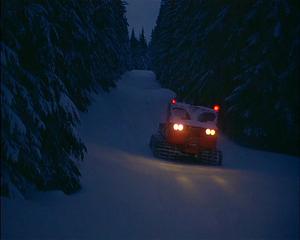
"KING CO., Wash.
Two hikers stranded on Rattlesnake Ridge were rescued Saturday night after hiking up a trail and getting lost.
Both men were uninjured.
According to King Co. Marine Rescue, the men were not dressed appropriately for the high level of snow.
King Co. Marine Rescue advised they were assisting in the rescue attempt at around 5 p.m.
The hikers were rescued a little before 7 p.m.
Rescuers used a military-grade Snocat to help rescue the men. Without the Snocat, the rescue could have taken up to four hours, King Co. Marine Rescue says. "
http://www.kirotv.com/news/news/hikers-stranded-rattlesnake-ridge/
|
| Back to top |
|
|
spamfoote
Member
Joined: 26 Oct 2014
Posts: 860 | TRs | Pics
|
Good grief, what is wrong with people? Walk downhill, self rescue your stupid butts.
|
| Back to top |
|
|
nordique
Member
Joined: 04 May 2008
Posts: 1086 | TRs | Pics
|
|
nordique
Member
|
Sun Jan 24, 2016 6:17 pm |
|
|
I was hoping someone had some additional information about why these two kids got into trouble and where they were. Rattlesnake Ridge covers a lot of territory and they were rescued by King County Maritime, using a military snocat? Where the heck were they? Up in the watershed?
I assume they were newbies, in pullovers and jogging shoes, no packs, just phones.
|
| Back to top |
|
|
tigermn
Member

Joined: 10 Jul 2007
Posts: 9242 | TRs | Pics
Location: There... |
|
tigermn
Member
|
Sun Jan 24, 2016 9:57 pm |
|
|
| nordique wrote: | | I was hoping someone had some additional information about why these two kids got into trouble and where they were. Rattlesnake Ridge covers a lot of territory and they were rescued by King County Maritime, using a military snocat? Where the heck were they? Up in the watershed?
I assume they were newbies, in pullovers and jogging shoes, no packs, just phones. |
Yea I was wondering the same thing, especially where were they? A lot of old logging roads/trails and such up on that ridge and in that area.
|
| Back to top |
|
|
Bernardo
Member

Joined: 08 Feb 2010
Posts: 2174 | TRs | Pics
Location: out and about in the world |
|
Bernardo
Member
|
Sun Jan 24, 2016 10:26 pm |
|
|
I randomly picked up two folks lost in the woods today. They had had a great day out together but were lost and weren't going to get out by dark. The difference between a good outing and something worse was pure luck. Very nice young people, maybe love had distracted them...
|
| Back to top |
|
|
Dect6
Member
Joined: 27 Mar 2011
Posts: 162 | TRs | Pics
|
|
Dect6
Member
|
Mon Jan 25, 2016 7:14 am |
|
|
Was Rattlesnake snowed in or something? Unless they went off path and needed the bob cat to plow a way thru it.
|
| Back to top |
|
|
boot up
Old Not Bold Hiker

Joined: 12 Dec 2006
Posts: 4745 | TRs | Pics
Location: Bend Oregon |
|
boot up
Old Not Bold Hiker
|
Mon Jan 25, 2016 9:07 am |
|
|
| Dect6 wrote: | | Was Rattlesnake snowed in or something? Unless they went off path and needed the bob cat to plow a way thru it. |
If you have ever hiked further than the teeming masses at Rattlesnake Ledge, where most of the world thinks the trail stops, you would know that the Rattlesnake Traverse (now known as the RMT) usually has a lot of snow in winter for a large portion of it, and often deep enough to warrant snowshoes.
Its always interesting doing the full traverse in winter, packing snowshoes, passing people with sneakers and flip flops at both ends, that look at you like you are crazy. On the other hand, you won't need a pricey snowcat rescue.
|
| Back to top |
|
|
Snowbrushy
Member
Joined: 23 Jul 2003
Posts: 6670 | TRs | Pics
Location: South Sound |
| Dect6 wrote: | | needed the bob cat to plow a way.. |
 shiningsnowcat
Oh Pilot of the storm who leaves no trace Like thoughts inside a dream Heed the path that led me to that place Yellow desert stream.
Oh Pilot of the storm who leaves no trace Like thoughts inside a dream Heed the path that led me to that place Yellow desert stream.
|
| Back to top |
|
|
cascadeclimber
Member

Joined: 04 Sep 2006
Posts: 1427 | TRs | Pics
|
I'm glad everyone, especially the rescue group is okay. That's by far the most important thing.
That said, I think this is the inevitable result of 'dumbing down' trails. Paved parking lots, paved roads, ubiquitous signage, fences, switchbacks, you name it. Some people become externally oriented for navigation and safety. They expect a sign or ranger to appear to tell them where not to go, where to go, how far they have to go, etc. And when it doesn't, they pull out a phone and call for it, instead of thinking.
Perhaps the one sign that should be at trailheads goes something like this:
"This trail accesses wild places. Knowledge of navigation, self-rescue, and snow travel (in winter) is required. Do not expect signs or directional assistance. Rescue, if required, may take many hours. Unmanaged danger, such as cliffs, falling trees and rocks, wild animals, etc. exist here. Do not proceed unless you are prepared."
|
| Back to top |
|
|
joker
seeker

Joined: 12 Aug 2006
Posts: 7953 | TRs | Pics
Location: state of confusion |
|
joker
seeker
|
Mon Jan 25, 2016 9:50 am |
|
|
It's kind of hard to make any clear and confident pronouncements about exact cause w/o a bit more info - perhaps it was better that they called for help in time for a near-dark rescue versus finding a way to get harder to find more fully into nighttime (perhaps going hypothermic and getting themselves hurt as a result in the process).
In any case, Rattlesnake Ledges, which we can hazard a guess was on the route of these folks, clearly shows the high demand in our increasingly populated area for no-permit-required buffed out hikes to nice views. It's no shock that some very small percent of the folks who head up there get into trouble. Less experienced hikers of course also get into trouble on less paved/signed/fenced (and of course the most horrific of all - switchbacked!!!  ) hikes too, but with the #'s and relative experience of the masses hitting Rattlesnake I'd frankly expect a bit more SAR activity up there. I'm glad so many folks get out into the woods and hills there (though after joining some friends there once last summer, I'm not eager to go back and spend the day swimming upstream!!).
Interesting that King County has a snow cat now - I wonder how often it will be helpful for SAR given the need for both road and snow. ) hikes too, but with the #'s and relative experience of the masses hitting Rattlesnake I'd frankly expect a bit more SAR activity up there. I'm glad so many folks get out into the woods and hills there (though after joining some friends there once last summer, I'm not eager to go back and spend the day swimming upstream!!).
Interesting that King County has a snow cat now - I wonder how often it will be helpful for SAR given the need for both road and snow.
|
| Back to top |
|
|
Snowbrushy
Member
Joined: 23 Jul 2003
Posts: 6670 | TRs | Pics
Location: South Sound |
| cascadeclimber wrote: | | Perhaps the one sign that should be at trailheads goes something like this: |
Do you know the difference between making a basic 911 emergency call and an SAR call? 911 discourages folks from making non-emergency calls, and SAR doesn't.
Oh Pilot of the storm who leaves no trace Like thoughts inside a dream Heed the path that led me to that place Yellow desert stream.
Oh Pilot of the storm who leaves no trace Like thoughts inside a dream Heed the path that led me to that place Yellow desert stream.
|
| Back to top |
|
|
nordique
Member
Joined: 04 May 2008
Posts: 1086 | TRs | Pics
|
|
nordique
Member
|
Tue Jan 26, 2016 8:05 pm |
|
|
I'm still mystified where that big snocat could go, in such a rescue situation. Were those being rescued up on the ledges? Or south of the education center? Or headed towards Cedar Butte?
|
| Back to top |
|
|
Kim Brown
Member
Joined: 13 Jul 2009
Posts: 6899 | TRs | Pics
|
Nordique, the ridge runs west from the ledges; the high point is Snoqualmie Point. I don't recall how long the ridge is, but much of it was a logging road. The watershed is on the south slope. I was confused at first as well when they said "closed watershed," because I forget that just below the ridge - even just off the Ledges trail, is closed watershed.
"..living on the east side of the Sierra world be ideal - except for harsher winters and the chance of apocalyptic fires burning the whole area."
Bosterson, NWHiker's marketing expert
"..living on the east side of the Sierra world be ideal - except for harsher winters and the chance of apocalyptic fires burning the whole area."
Bosterson, NWHiker's marketing expert
|
| Back to top |
|
|
|
|


