| Previous :: Next Topic |
| Author |
Message |
wildernessed
viewbagger


Joined: 31 Oct 2004
Posts: 9275 | TRs | Pics
Location: Wenatchee |
Location : North of Winthrop at the West end of Eightmile Rd. / Billy Goat TH
Map : GTM - Billy Goat Mountain, TOPO
Stats : 14.7 mi, 7030' loop
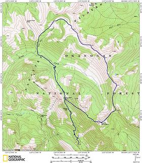 Billy Goat - Eightmile Ridge - Two Bit Creek Loop 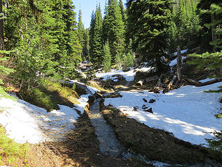 Billy Goat Trail 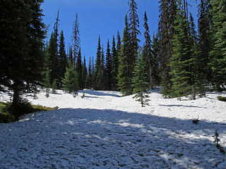 Nearing Billy Goat Pass at 6600' 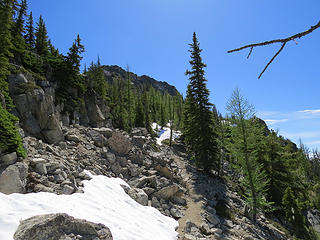 Burch Mtn. / Eightmile Ridge Trail from Billy Goat Pass 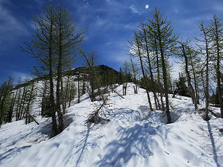 Lots of snow in the saddle. 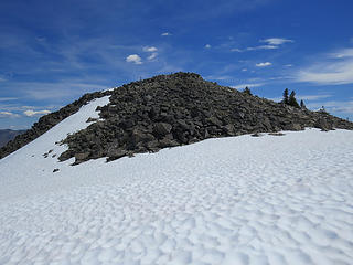 Burch Peak 7782' 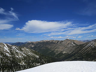 From Burch looking at our destination across Drake Creek drainage. 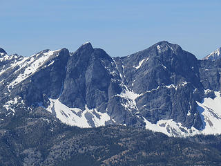 Three Pinnacles 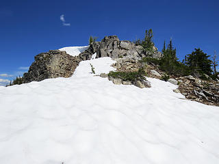 7482' 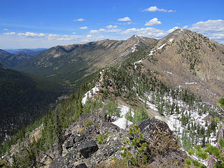 On the North ridge of 7482, some maps have the entire ridge listed as part of Eightmile Ridge. 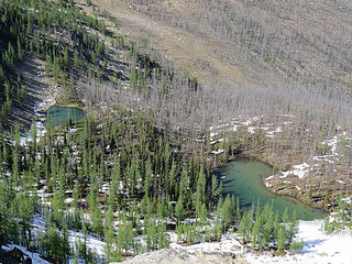 Unnamed lakes just East of the ridge. 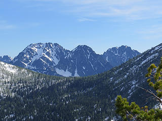 Big Craggy, North Craggy, West Craggy 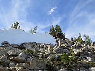 Steve high on GU leads the assault on 8055' 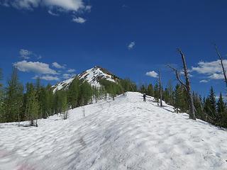 Heading for 8055' 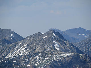 Peepsight 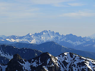 Silver Star 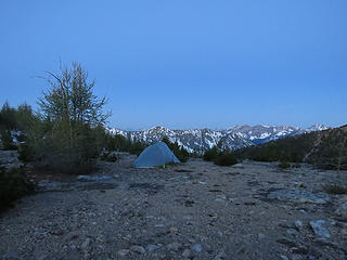 Steve strategically set his tent up for views. 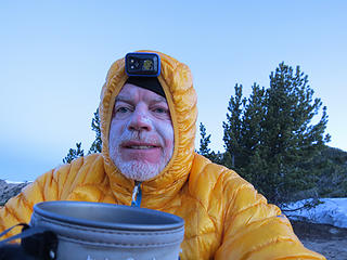 Early A.M. at camp in a saddle at 7540' 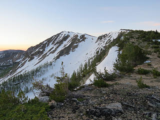 Looking back at 7987' 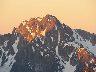 West Craggy in the morning. 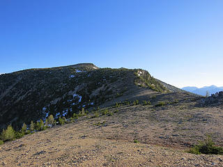 Point 8062' and a ridge route out to Fool Hen and Fox Lakes. 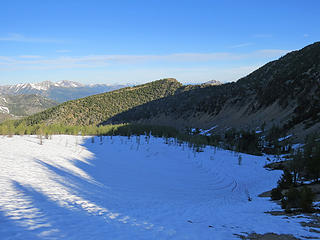 Head of Two Bit Creek where we dropped down off the main ridge down to the Larch Creek Trail (205) then back towards Billy Goat Pass from the North. 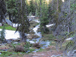 Upper Two Bit Creek 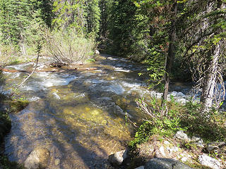 Drake Creek Ford 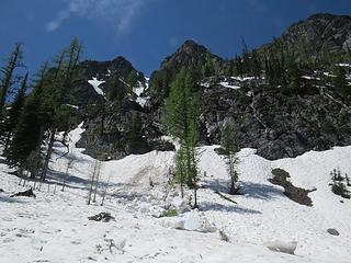 Slide off Billy Goat. 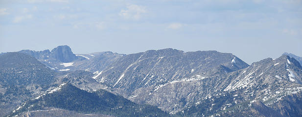 Cathedral - Ampitheater - Andrews - Peepsight and smokey haze 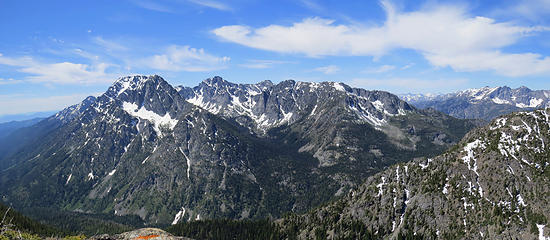 Craggies and Eightmile 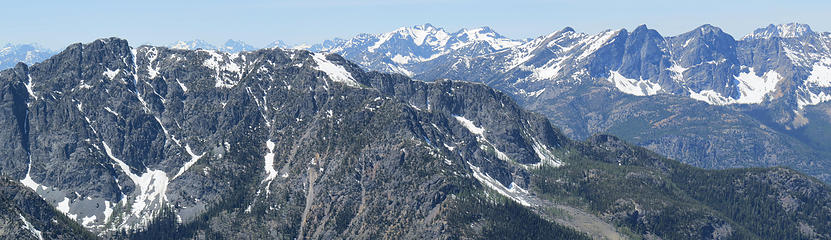 Eightmile 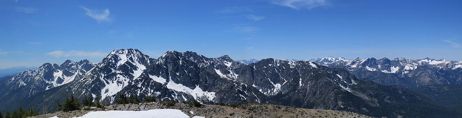 Isabella Ridge Peaks and more 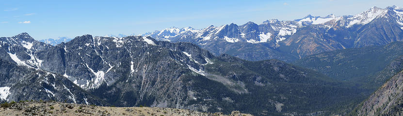 Route options for Eightmile 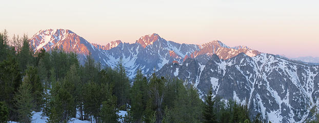 Views with morning joe. 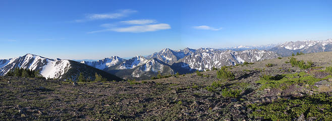 Views as we drop into Two Bit Creek Drainage 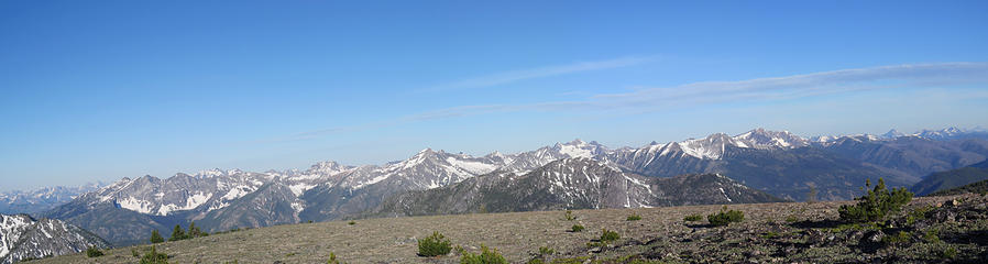 Views off 7836' 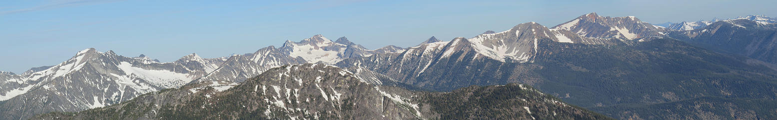 Pasayten Peaks
Living in the Anthropocene
Living in the Anthropocene
|
| Back to top |
  
|
|
Distel32
Member

Joined: 03 Jun 2014
Posts: 961 | TRs | Pics
Location: Edmonds, WA |
|
Distel32
Member
|
 Tue Jun 07, 2016 5:53 pm |
|
|
 nice and good Pasayten snotel update! And now I know what it looks like nice and good Pasayten snotel update! And now I know what it looks like 
|
| Back to top |
|
|
fourteen410
Member

Joined: 23 May 2008
Posts: 2629 | TRs | Pics
|
Thanks for the info!
|
| Back to top |
|
|
wildernessed
viewbagger
Joined: 31 Oct 2004
Posts: 9275 | TRs | Pics
Location: Wenatchee |
Yeah look at the lack of snow back in that area and at elevation. The trails and snow in unexposed areas lower is what slows you down those slopes and ridges look good for getting around. I had surgery and couldn't hike for nearly 4 weeks so I didn't have a clue as to the conditions but it looks like summer. They are doing controlled burns in the area and the lower end of Eightmile was very smokey, but the Upper end was fine. Driving the road up they were doing controlled burns right across from campsites where people were camping. 
Living in the Anthropocene
Living in the Anthropocene
|
| Back to top |
|
|
raising3hikers
Member
Joined: 21 Sep 2007
Posts: 2344 | TRs | Pics
Location: Edmonds, Wa |
i also appreciate the update for the area! thanks and glad you guys had a good trip
|
| Back to top |
|
|
silence
Member

Joined: 25 Apr 2005
Posts: 4420 | TRs | Pics
|
|
silence
Member
|
Tue Jun 07, 2016 6:29 pm |
|
|
I'm always jealous of your early season outings ... nice work! Love the pix!
PHOTOS
FILMS
Keep a good head and always carry a light bulb. Bob Dylan
PHOTOS
FILMS
Keep a good head and always carry a light bulb. Bob Dylan
|
| Back to top |
|
|
HitTheTrail
Member

Joined: 30 Oct 2007
Posts: 5460 | TRs | Pics
Location: 509 |
Yup, looks like a killer trip in more ways than one. Looks like the dudes nailed it again.
|
| Back to top |
|
|
Distel32
Member
Joined: 03 Jun 2014
Posts: 961 | TRs | Pics
Location: Edmonds, WA |
|
Distel32
Member
|
Tue Jun 07, 2016 7:26 pm |
|
|
Now you're going to make me have a total 6hrs+ of driving this weekend  
|
| Back to top |
|
|
Leafguy
Member
Joined: 16 Sep 2003
Posts: 525 | TRs | Pics
Location: Wenatchee |
|
Leafguy
Member
|
Tue Jun 07, 2016 9:34 pm |
|
|
I'm telling your doctor 
|
| Back to top |
|
|
wildernessed
viewbagger
Joined: 31 Oct 2004
Posts: 9275 | TRs | Pics
Location: Wenatchee |
| Leafguy wrote: | | I'm telling your doctor |
He told me I could go hiking and running. 
Living in the Anthropocene
Living in the Anthropocene
|
| Back to top |
|
|
Brockton
Member
Joined: 02 Aug 2012
Posts: 266 | TRs | Pics
Location: West Seattle |
|
Brockton
Member
|
Wed Jun 08, 2016 6:52 am |
|
|
Thanks for the report.
What's the road like up to the trailhead? Anything rough for a passenger car?
|
| Back to top |
|
|
Get Out and Go
Member

Joined: 13 Nov 2004
Posts: 2128 | TRs | Pics
Location: Leavenworth |
Glad to see a TR from you again...and a hearty one at that. 
"These are the places you will find me hiding'...These are the places I will always go."
(Down in the Valley by The Head and The Heart)
"Sometimes you're happy. Sometimes you cry.
Half of me is ocean. Half of me is sky."
(Thanks, Tom Petty)
"These are the places you will find me hiding'...These are the places I will always go."
(Down in the Valley by The Head and The Heart)
"Sometimes you're happy. Sometimes you cry.
Half of me is ocean. Half of me is sky."
(Thanks, Tom Petty)
|
| Back to top |
|
|
HitTheTrail
Member
Joined: 30 Oct 2007
Posts: 5460 | TRs | Pics
Location: 509 |
| wildernessed wrote: | | We eventually hit a nice, dry trail (Larch Creek) but soon realized we would have to ford Two Bit Creek |
After looking at the map I am assuming this was trail #502 that goes to Larch Creek since you were still a ways away from Larch Creek? I hope that trail is good all the way in. I have been mentally planning a trip to camp near Larch Pass and day hike around Sand Ridge and some of the nearby lakes/meadows. Once more of the snow gets knocked down of course.
|
| Back to top |
|
|
wildernessed
viewbagger
Joined: 31 Oct 2004
Posts: 9275 | TRs | Pics
Location: Wenatchee |
| HitTheTrail wrote: | | I hope that trail is good all the way in. |
I wish it was Hit the Trail there is sporadic down fall before The Billy Goat / Eightmile split and Billy Goat is a mess especially after the Pass. I anticipated fording Two Bit and Drake creeks so we brought those UL camp shoes and were fine. The water was knee high in the a.m. I think taking Larch Creek to Fox Lakes then looping back over those 8000' peaks, hitting Fool Hen lake and dropping down Two Bit like we just did would be a great outing but I won't be going that way until the down fall is cleared out. That basin in Two Bit was nice.
Living in the Anthropocene
Living in the Anthropocene
|
| Back to top |
|
|
wildernessed
viewbagger
Joined: 31 Oct 2004
Posts: 9275 | TRs | Pics
Location: Wenatchee |
| Brockton wrote: | | Thanks for the report.
What's the road like up to the trailhead? Anything rough for a passenger car? |
The road was in great shape. Better than years past.
Living in the Anthropocene
Living in the Anthropocene
|
| Back to top |
|
|
|
|


