| Previous :: Next Topic |
| Author |
Message |
cambajamba
Member


Joined: 05 Nov 2011
Posts: 339 | TRs | Pics
|
I have heard rumors that an old campground existed on the east side of the confluence of the Middle Fork Snoqualmie and Taylor rivers. All I have heard is that it existed, was closed due to either lack of funds or a massive slump/slide, and was used after it was permanently closed for some sort of big party/rave/youth jamboree that happened on an annual basis. I cannot for the life of me find links to where I heard or read this information. My understanding is that historically one would go up and over "hell hill" en route to the road end at Dutch Miller (at that time) and then turn right at the bottom of the hairpin turns that bring you back to river grade after the hill. It was somewhere back in there. I'd believe this, as when you drive through the area now there's clearly an old road that cuts back in there and some shaky treads still evident on the ground once the old road peters out.
Even in the time I've been going back in there (since about 2000) there have been new slumps/slides above the area, nearly cutting into the road over hell hill at that one point near the waterless camp.
Can anyone tell me anything about:
The facility that used to be there?
Was there even a formal campground or just a spur road with dispersed camping?
The parties that took place after the closure?
Were these even formal parties or is this just where all the keggers used to happen?
What caused the closure and decomissioning of that spur road?
Anyone been back in there recently? Last winter I took a peek to the spur end and saw rough tracks continuing, but I wasn't prepped for brush bashing in the rain so I backed out.
|
| Back to top |
  
|
|
Mike Collins
Member
Joined: 18 Dec 2001
Posts: 3097 | TRs | Pics
|
The next time that you need a haircut you should go to Mike's Barber Shop in Gold Bar. Call the shop before you go to make sure that Mike will be there as the barber. He offers a wealth of information about the Taylor River and the Middle Fork area. He owns a large section of land in that area and told me that the Forest Service wanted an easement to build one of their trails across his land. He will regale you with stories and entertain you for the entire time of your haircut. He told me that it bothers him that the Forest Service was giving tickets to cars that were parked on his land near the trailhead. It didn't bother him that people parked on his property. He had nothing good to say about the Forest Service. I called the shop and he answered the phone telling me that there used to be an old campground. But if you have the time to patronize his shop you will be greatly rewarded with the information he offers.
|
| Back to top |
|
|
cambajamba
Member
Joined: 05 Nov 2011
Posts: 339 | TRs | Pics
|
Does he trim beards? Cause I'm bald as hell. Thanks for the advice!
|
| Back to top |
|
|
RichP
Member

Joined: 13 Jul 2006
Posts: 5634 | TRs | Pics
Location: here |
|
RichP
Member
|
 Fri Jan 12, 2018 3:39 pm |
|
|
Here's a blog post that makes reference to a campground but doesn't offer much more than that. The 1960 USGS map at the bottom shows a Taylor River Forest Camp.
http://rubble.blogspot.com/2012/09/middle-fork-snoqualmie-camp-brown.html
| Quote: | | I, also, know nothing about the Taylor River Campground (1950s-70s) and the old ranger station mentioned above. More old sites to check out? Further research is required. |
![image_thumb[1]](https://cloud.nwhikers.net/38759433145_410x240.jpg) image_thumb[1]
|
| Back to top |
|
|
Randito
Snarky Member

Joined: 27 Jul 2008
Posts: 9513 | TRs | Pics
Location: Bellevue at the moment. |
|
Randito
Snarky Member
|
Fri Jan 12, 2018 4:57 pm |
|
|
I don't have any online references -- but I launched kayaks and my drift boat from that camp ground back in the '80s to float the "upper middle fork" from there down to the "concrete bridge"
Pleasant class II rapids along that section -- I gravel bar camped out of the drift boat with my kids around 1989 -- unfortunately "plinkers" shooting somewhat randomly in the area made this outing less relaxing than I'd hoped for -- I'm sure it's better now than it was back in the '80s which burned out cars and shot up TVs lined the road between the "concrete bridge" and the Taylor river bridge.
|
| Back to top |
|
|
Damian
Member

Joined: 18 Dec 2001
Posts: 3260 | TRs | Pics
|
|
Damian
Member
|
Fri Jan 12, 2018 6:30 pm |
|
|
I remember the campground. It is shown on the 1975 Green Trails map and others. There was no trace of it last time I poked around the area about 10 years ago.
|
| Back to top |
|
|
Dusty Trale
Member
Joined: 24 Nov 2014
Posts: 49 | TRs | Pics
Location: East of Redmond |
In my copy of the old "Trips and Trails, 2" book by E.M. Sterling published by the Mountaineers in 1968 it has this write up about the campground, "Taylor River - 21 sites on a bar formed by the Snoqualmie River and Taylor River. A timbered area with undergrowth of vine maple and alder. Some sites near the rivers. Other back from the streams. All off several spurs near the entrance. Pit toilets."
|
| Back to top |
|
|
contour5
Member

Joined: 16 Jul 2003
Posts: 2963 | TRs | Pics
|
|
contour5
Member
|
Fri Jan 12, 2018 9:25 pm |
|
|
I vaguely remember a high school beer pachanga at this location in '72 or '73. About a dozen of us spent the night huddled around the fire under a couple of big plastic tarps. It was wet and cold, but we were well fortified with cheap liquor and moldy dirtweed. The next morning we attempted to walk up Taylor River, but got turned around by the rain.
The best part of the trip was stopping in at the gas station at the E end of North Bend on the way up, to ask directions. Four grease stained mechanics were sitting around in the back, drinking lunch. After looking us up and down, and spewing out copious quantities of tobacco juice, they all replied at the same time:
"What the hell you wanna go up there for?"
"Course it's that way- where else would it be?"
"Yeah, you can't miss it."
"Just follow the rest of the gawd dam hippies!"
|
| Back to top |
|
|
Malachai Constant
Member

Joined: 13 Jan 2002
Posts: 16092 | TRs | Pics
Location: Back Again Like A Bad Penny |
I think the whole area was washed out by a flood some time in the 70's early 80's as long as I remember there was nothing but rocks and mud.
"You do not laugh when you look at the mountains, or when you look at the sea." Lafcadio Hearn
"You do not laugh when you look at the mountains, or when you look at the sea." Lafcadio Hearn
|
| Back to top |
|
|
puzzlr
Mid Fork Rocks

Joined: 13 Feb 2007
Posts: 7220 | TRs | Pics
Location: Stuck in the middle |
|
puzzlr
Mid Fork Rocks
|
Sat Jan 13, 2018 12:05 am |
|
|
That old campground was on USFS Recreation Maps as late as 1978, but was not on the 1988 map. I don't know exactly when it was shut down, but heard that there was too much partying and vandalism to make it feasible to manage. The same thing happened at the DNR Mine Creek camp further downstream and that was closed down in 1994.
It's not very easy to get to the old campground now because the river has eaten away the old roadway from the far end of the Hell Hill switchback and most of the year you need to walk through a swamp to get there. During low water periods you can walk down the Taylor River gravel bars to get there. But many floods on the Taylor River over the years have sliced several channels through what remains of the campground and it's difficult to pick out anything. This is one spot that still looks like the old campground loop road.
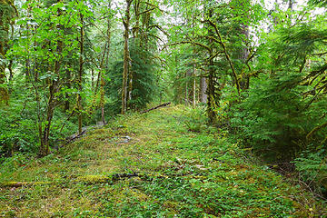 old Taylor Campground road 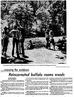 Buffalo Party gathers at the old Taylor River campground on July 4, 1971
|
| Back to top |
|
|
RichP
Member
Joined: 13 Jul 2006
Posts: 5634 | TRs | Pics
Location: here |
|
RichP
Member
|
Sat Jan 13, 2018 10:20 am |
|
|
Yay hippies! I knew you'd have some good info, puzzlr.
|
| Back to top |
|
|
joker
seeker

Joined: 12 Aug 2006
Posts: 7953 | TRs | Pics
Location: state of confusion |
|
joker
seeker
|
Sat Jan 13, 2018 6:08 pm |
|
|
|
| Back to top |
|
|
lopper
off-route

Joined: 22 Jan 2002
Posts: 845 | TRs | Pics
|
|
lopper
off-route
|
Sun Jan 14, 2018 4:08 pm |
|
|
The keggers were history, and the campground loop was getting overgrown when I took this picture in 1977. This is the temporary RR flatcar bridge over the Taylor River, about 100 yds upstream from the MFK confluence, immediately W of the campground.
While it lasted, it was a great way to avoid the obnoxious & rocky up/down loop on the upper MFK Road, heading for Dingford. The bridge itself was fine....the challenge was negotiating the cobble up-ramps.
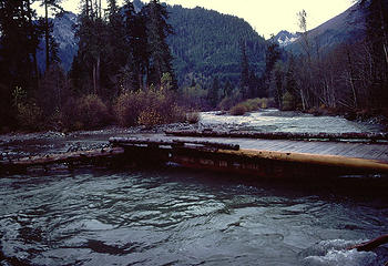 77TaylorFlatcar
|
| Back to top |
|
|
cambajamba
Member
Joined: 05 Nov 2011
Posts: 339 | TRs | Pics
|
Holy History NWHiker-ites!
Thank you all so much for the thorough replies - this is way more information than I expected to find! I had heard "there was a big bash" at some point but 700 people!? I just camped at those river-adjacent spots near the bottom switchback coming down from Hell Hill this weekend (gimpy friend needed a camp trip, can't walk far) and it was so silent and still back in those woods. It's incredible to think about the difference in scene.
I still want to get back in there, even if most traces of it are long gone now and across a swamp - can't wait to see what's remaining now.
The RR flatcar bridge is intriguing to me - so you had to 4x4 across the river bars until you got to the main channel and then get over on the flatcar? Was this because there was no Taylor river bridge at the time or because it had been temporarily washed out?
|
| Back to top |
|
|
puzzlr
Mid Fork Rocks
Joined: 13 Feb 2007
Posts: 7220 | TRs | Pics
Location: Stuck in the middle |
|
puzzlr
Mid Fork Rocks
|
Tue Jan 16, 2018 4:48 pm |
|
|
There was a bad stretch for the Taylor River bridge in the 1970s.
- Jan 18, 1975 - Peak flow 24,900 cfs took out Taylor River bridge, which was less than 3 years old. This flood was the 12th largest to date since the gage was installed in 1961. At this time the bridge was still near the confluence with the Middle Fork river.
- Dec 01, 1975 - 14th largest flood to-date peaked at 23,700 cfs, but bridge was already out anyway.
- Summer, 1975 - 4-wheel crossing of Taylor confluence banned because of damage to vegetation and banks
- Summer, 1977 - USFS installs a temporary bridge during summer months (lopper's photo)
- Fall, 1977 - Plans to fix the road and bridge stalled because the first 6 or 7 miles are still on private land, King County doesn't want to pay.
- Dec 02, 1977 - 4th largest flood to-date peaked at 30,200 cfs. It's good they didn't fix the bridge yet.
- Spring, 1978 - USFS "seeking funds to build a year-round single-lane wood structure" across the Taylor River
- Summer, 1978 - USFS again installs a temporary bridge
- May, 1979 - New Taylor River bridge is in place but located at the current position, about 1/4 miles upstream.
- March, 1983 - Bridge damaged. Not sure if it was a complete washout
- 1988 - Current concrete bridge built
- Jan 7, 2009 - Far end of current bridge washes out in 3rd largest flood to-date, peaking at 31,200 cfs
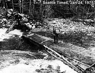 1975 Taylor River Bridge washout. Seattle Times, Jan 24, 1975 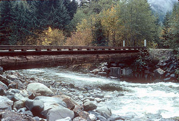 1979 Taylor River Bridge. Photo by Charlie Hickenbottom 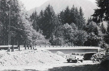 1989 Taylor River Bridge shortly after construction. Photo from Goldmyer newsletter 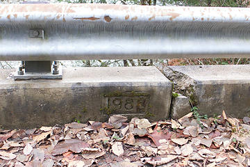 1988 cornerstone on current Taylor River bridge 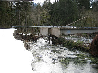 Taylor River bridge after the 2009 flood. Photo by Aaron Pease.
|
| Back to top |
|
|
|
|


![image_thumb[1]](https://cloud.nwhikers.net/38759433145_bf972b33f0_o.jpg#644x377+https://farm5.staticflickr.com/4608/38759433145_bf972b33f0_o.jpg#644x377)


