| Previous :: Next Topic |
| Author |
Message |
kitya
Fortune Cookie


Joined: 15 Mar 2010
Posts: 842 | TRs | Pics
Location: Duvall, WA |
|
kitya
Fortune Cookie
|
 Sun Dec 06, 2020 11:13 am |
|
|
Via Dingford creek trail
Sorcery Mountain aka P5270 is unofficially named to fit the nearby (officially named) Merlin Lake, Nimue Lake (Merlin's lover), and Le Fay Lake (Morgan Le Fay, Merlin's student and King Arthur's sister).
The hardest part of this hike is the driving to the trailhead. After an amazing smooth drive on the newly paved section of Middle Fork Road (up to mile 12) you have to turn right and the next 6 miles are some worst of the least maintained forest service roads out there. It took me close to an hour to drive 6 miles. It is not scary, because the road follows the valley and doesn't have any steep drop offs, but it is muddy, rocky and filled with frozen potholes big enough to eat someone alive. There are also three spots with big sharp dips, where creeks completely washed out sections of the road. The middle washout is the worst, but trucks already made another trail curving on the side through the creek. On the way to the trailhead I followed the curvy trail around the washout, but on the way back, when I was driving in the darkness and couldn't see the trail, I missed it and drove directly through the middle washout instead. My poor car made some very scary sounds doing it.
Anyway, after 6 miserable miles you get to a giant flat well-developed trailhead with a lot of parking and a closed ("due to lack of funding") restroom. There were two cars at the trailhead before us already, but I didn't see any people on the trail, I suspect most people who drive this road go to visit the amazing Goldmeyer hot springs.
Dingford creek trail starts rocky, but is surprisingly well maintained and easy to walk on. Patches of somewhat deep snow start around 2500 feet, but after a week of dry weather some areas are completely melted out. It is really smooth and easy sailing to the intersection with Goat creek.
From the previous reports I knew there supposed to be a trail/bootpath all the way to Horseshoe lake, but I couldn't find it. Stubbornly I avoided coming too close to the creek (usually creek beds have lots of blowdowns) and instead me and Cookie had to fight a very slow fight up through blowdowns, devils club, wet sliding snow, hidden creeks and rocks. It was very tedious and I never found the boot path on the way up. However, I have seen one hericium, old cow, quite a few big golden chanterelles and also a few tiny yellow feet (AKA winter chanterelles) growing right through the snow. In the process Cookie also found some deer (or maybe snowshoe hare) poop and ate it. Finally, around 3800 snow coverage became good enough for snowshoes and things got better from there.
On my way back down I did manage to find the boot path, it is slightly more visible going down, and is a lot closer to the creek than I would have expected. The boot path is not perfect and completely disappears in places (or maybe I just lost it), but it is a whole lot better than battling through devils club the whole way.
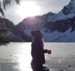
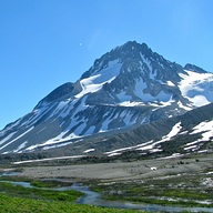
Horshoe lake was frozen and from the lake me and Cookie followed an obvious ridge all the way up to the false summit. This part is really fun. The ridge is sometimes narrow and steep and choked with giant boulders, but there is always a zig-zagy way to come up, sometimes using veggie belays. Finally from the false summit it is another few feet of scrambling to the true summit. It was sunny and very warm, so snow was very wet and not very stable, but the views are quite great, and include Dakobed and Tahoma.
 Now I Fly Now I Fly
Now I Fly |
| Back to top |
  
|
|
zephyr
aka friendly hiker

Joined: 21 Jun 2009
Posts: 3370 | TRs | Pics
Location: West Seattle |
|
zephyr
aka friendly hiker
|
Sun Dec 06, 2020 12:53 pm |
|
|
| kitya wrote: | | There are also three spots with big sharp dips, where creeks completely washed out sections of the road. The middle washout is the worst, but trucks already made another trail curving on the side through the creek. On the way to the trailhead I followed the curvy trail around the washout, but on the way back, when I was driving in the darkness and couldn't see the trail, I missed it and drove directly through the middle washout instead. My poor car made some very scary sounds doing it. |
Great report. Yes, that middle washout can get really deep at times. This year the local stakeholders had to knock down the sides to level it out from last winter's storms. Usually if you enter it at an angle it's not quite so rough. It also helps to get out and scout it (the washout) if you haven't been down that road in awhile.
The potholes are enormous and it's difficult to see bottom when they are filled with water. ~z
|
| Back to top |
|
|
kitya
Fortune Cookie
Joined: 15 Mar 2010
Posts: 842 | TRs | Pics
Location: Duvall, WA |
|
kitya
Fortune Cookie
|
Sun Dec 06, 2020 7:47 pm |
|
|
| zephyr wrote: | | Great report. Yes, that middle washout can get really deep at times. This year the local stakeholders had to knock down the sides to level it out from last winter's storms. Usually if you enter it at an angle it's not quite so rough. It also helps to get out and scout it (the washout) if you haven't been down that road in awhile. |
Yeah, I did much better in the morning, when I still could see the road and around. Unfortunately darkness comes really early now and it gets very-very dark there. Car headlights are very directional, so it is bright only straight ahead and very hard to see what is down or on the sides. If I ever try this road next time, I will try to make sure not driving it at night.
|
| Back to top |
|
|
KascadeFlat
Member
Joined: 06 Jul 2020
Posts: 314 | TRs | Pics
Location: Eating peanut M&Ms under my blue tarp |
Great report! I love visiting the little peaks and lakes that jump off from the Middle Fork and seeing folks make trips to places like Sorcery is inspiring. The bushwhacking back there can be ferocious -- as your GPS track clearly attests. 
For a good time call: 1-800-SLD-ALDR.
For a good time call: 1-800-SLD-ALDR.
|
| Back to top |
|
|
kitya
Fortune Cookie
Joined: 15 Mar 2010
Posts: 842 | TRs | Pics
Location: Duvall, WA |
|
kitya
Fortune Cookie
|
Mon Dec 07, 2020 12:05 pm |
|
|
| KascadeFlat wrote: | | Great report! I love visiting the little peaks and lakes that jump off from the Middle Fork and seeing folks make trips to places like Sorcery is inspiring. The bushwhacking back there can be ferocious -- as your GPS track clearly attests. |
Yeah, it is not pleasant going up to the lake, but such smooth sailing after the lake to the summit.
Also continuing with tradition I broke one of my two super expensive carbon hiking BD poles. But at least I didn't lose it!
|
| Back to top |
|
|
puzzlr
Mid Fork Rocks

Joined: 13 Feb 2007
Posts: 7220 | TRs | Pics
Location: Stuck in the middle |
|
puzzlr
Mid Fork Rocks
|
Mon Dec 07, 2020 1:34 pm |
|
|
Thanks for writing a report on this peak. It's fun to work out a route through the rocks on that last ridge is to the summit. I'm sorry but not surprised you had trouble finding the Horseshoe Lake trail. Even though I had been up it 3 times before, we had trouble finding the beginning this spring. I don't think it's getting much use because it was easier to follow 5 years ago.
There was a lot of blow down on the Dingford Creek trail from last winter but crews worked hard to clear it this spring.
I drive the gravel road past the Taylor River junction so often I don't think about the pot holes so much any more. I guess you can get used to anything, but I agree that it is in worse shape this year with more and bigger holes than in recent years. In the 2005 ATM plan the USFS committed to maintenance level 2 for this segment. I'd say they are pressing the limits of that level, but there's no level 1.5 -- maintained for no user convenience and probable damage to most vehicles  .
USFS maintenance levels
1: Closed to motorized access.
2: High-clearance vehicles. Passenger car traffic, user comfort, and user convenience are not considerations.
3: Maintained for travel by a prudent driver in a standard passenger car. User comfort and convenience are not considered priorities.
4: Moderate degree of user comfort and convenience at moderate travel speeds.
5: High degree of user comfort and convenience, normally double laned and paved.
BTW, many refer to that middle (and largest) stream crossing as "Garfield Wash" because it drains the Great Canyon that comes down from the summit of Garfield. The next stream just a few hundred yards further also blows out almost every winter and has the colorful and descriptive name "Oil Pan Creek".
Garfield Wash .
USFS maintenance levels
1: Closed to motorized access.
2: High-clearance vehicles. Passenger car traffic, user comfort, and user convenience are not considerations.
3: Maintained for travel by a prudent driver in a standard passenger car. User comfort and convenience are not considered priorities.
4: Moderate degree of user comfort and convenience at moderate travel speeds.
5: High degree of user comfort and convenience, normally double laned and paved.
BTW, many refer to that middle (and largest) stream crossing as "Garfield Wash" because it drains the Great Canyon that comes down from the summit of Garfield. The next stream just a few hundred yards further also blows out almost every winter and has the colorful and descriptive name "Oil Pan Creek".
Garfield Wash
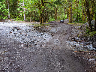 May, 2020 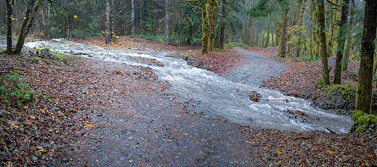 October 21, 2019 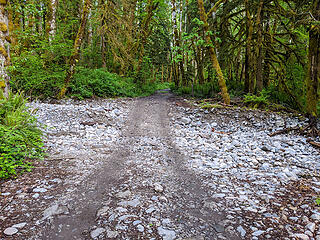 May, 2020 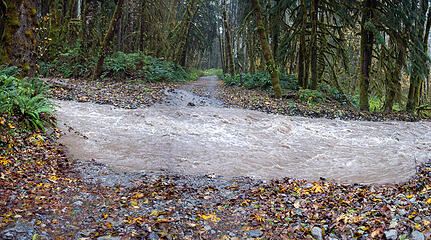 October 21, 2019 (I had to turn back here)
|
| Back to top |
|
|
zephyr
aka friendly hiker
Joined: 21 Jun 2009
Posts: 3370 | TRs | Pics
Location: West Seattle |
|
zephyr
aka friendly hiker
|
Mon Dec 07, 2020 3:16 pm |
|
|
| puzzlr wrote: | | BTW, many refer to that middle (and largest) stream crossing as "Garfield Wash" because it drains the Great Canyon that comes down from the summit of Garfield. The next stream just a few hundred yards further also blows out almost every winter and has the colorful and descriptive name "Oil Pan Creek". |
Thank you so much puzzlr for including those photographs of the above two washes both dry and at flood. That really explains how those road crossings take their shape. I also appreciate getting the nomenclature down. I had heard of Garfield Wash from a local guy this spring but wasn't 100% sure it was the "middle" one. Also nice to know the FS road ratings.  ~z
P.S. That May, 2020 photo is after the improvements this year. It was much deeper with steep walls when I bicycled it on May 7 (just after they opened the Middle Fork to traffic following that slide repair). I should think that this is an annual thing most spring seasons--smoothing out that wash. Sorry for the thread drift kitya. ~z
P.S. That May, 2020 photo is after the improvements this year. It was much deeper with steep walls when I bicycled it on May 7 (just after they opened the Middle Fork to traffic following that slide repair). I should think that this is an annual thing most spring seasons--smoothing out that wash. Sorry for the thread drift kitya.
|
| Back to top |
|
|
kitya
Fortune Cookie
Joined: 15 Mar 2010
Posts: 842 | TRs | Pics
Location: Duvall, WA |
|
kitya
Fortune Cookie
|
Mon Dec 07, 2020 4:19 pm |
|
|
Thanks! Actually Garfield Wash looked worse to me now than on May 2020 photo, but maybe because I was scared of it.
The USFS document is quite fun. If only they were as good at maintaining forest road as they are at word formatting skills  )) ))
|
| Back to top |
|
|
puzzlr
Mid Fork Rocks
Joined: 13 Feb 2007
Posts: 7220 | TRs | Pics
Location: Stuck in the middle |
|
puzzlr
Mid Fork Rocks
|
Mon Dec 07, 2020 5:53 pm |
|
|
| kitya wrote: | | Garfield Wash looked worse to me now than on May 2020 photo |
That's because it IS worse now. As vehicles try to drive straight through instead of taking the left-side route the spinning tires trying to climb the far bank have eroded multiple depressions and bumps in the bank. Until about a month ago I drove straight through with my Forester, but now I always go around.
|
| Back to top |
|
|
Type E
Member

Joined: 19 Aug 2006
Posts: 1381 | TRs | Pics
|
|
Type E
Member
|
Mon Dec 07, 2020 9:35 pm |
|
|
One of my favorite summits , too bad the trail is hard to follow . It was smooth sailing the times I used it .
|
| Back to top |
|
|
BeardoMcGrath
Member
Joined: 16 Jan 2018
Posts: 143 | TRs | Pics
Location: Snohomish |
Nice report; I snowshoed up there a couple years ago but in March, which allowed me to avoid as much bushwhacking thanks to snow cover. I like this summit as a winter ascent since there is pretty minimal avalanche risk but you still get great, open views from the top.
|
| Back to top |
|
|
Pyrites
Member

Joined: 16 Sep 2014
Posts: 1884 | TRs | Pics
Location: South Sound |
|
Pyrites
Member
|
Tue Dec 08, 2020 7:38 pm |
|
|
Keep Calm and Carry On?
Heck No.
Stay Excited and Get Outside!
|
| Back to top |
|
|
Cyclopath
Faster than light

Joined: 20 Mar 2012
Posts: 7721 | TRs | Pics
Location: Seattle |
|
Cyclopath
Faster than light
|
Wed Dec 09, 2020 7:26 pm |
|
|
| puzzlr wrote: | October 21, 2019 |
Such a great photo, I love the way the road disappears off into the distance like something from a storybook. I rode this on a gravel bike, this exact spot was dry and rocky and might have been the hardest part of the day. It was obviously from water but it's interesting to actually see it. Thanks for posting this!
|
| Back to top |
|
|
|
|


