| Previous :: Next Topic |
| Author |
Message |
wiki summary
|
Current status of the NWHTSR
Awaits you on Sauk Mountain
Old Log Book(s):
- July 23rd, 2005 - April 26th, 2009
Previously on: (map)
- Poe Mountain
- Whittier Peak
- Gothic Peak
- Kendall Peak
- Huckleberry Mountain
- Alaska Mountain
- Kendall Peak
- Bryant Peak
- Yellow Aster Butte
- Terrace Mountain
- Trico
- McClellan Butte
- Hi Box
- Spring Mountain
- Breccia
- Tumac
- American Ridge
- Alaska Mountain
- Stilliguamish Peak
- Mount Forgotten
- Bogachiel Peak
- Welch Peaks
- Pyramid Mountain
- Granite Mountain (Wenatchee Mountains)
- Red Mountain (Snoqualmie Pass North)
- Floating Rock
- Galleon Peak
- Granite Mountain (Snoqualmie Pass North)
- Mt. Aix
- Puffer Butte
- Whitestone Rock
- Wapaloosie Mountain
- Antoine Peak
- Day Mountain (Mount Spokane State Park)
- Sauer's Mountain
- Putrid Pete's Peak
- Mailbox Peak
- Mount Teneriffe
- Rock Mountain
- Granite Mountain (Snoqualmie Pass North)
- Mount Kent
- Spark Plug
- Antler Peak, MRNP
- Dege Peak
- Crystal Mountain (Silver King) (The King)
- Mt. Forgotten
- Boulder Top Spire (Sherpani)
- Mac Peak (AWOL)
NWHTSR #2
1. Sauk Mountain
Wiki summmary last edited by veronika on Sat Jun 15, 2019 7:27 pm (this post can be edited by any member)
Wiki summmary last edited by veronika on Sat Jun 15, 2019 7:27 pm (this post can be edited by any member) |
| Back to top |

|
 |
naturealbeing
Member

Joined: 05 Dec 2004
Posts: 1565 | TRs | Pics
Location: Great Mystery |
Destination Whittier Peak.
After checking out the trip reports on WTA I thought that Whittier would be a good choice for the first placement of the NWHikers Traveling Summit Register
As the reports on WTA give an accurate account of the route I will let their words speak for me (Heres the link: http://www.wta.org/~wta/cgi-bin/wtaweb.pl?7+ds+WHITTIER%20PK+exact+trails+wta++all+3+on+browse) . I will add that I went up and over the NW ridge of Longfellow at about 6,000 ft. From this vantage point the view of Whittier gives one the illusion of either of being close or far away. From this point to the base of the summit rock is a rock fest. If you like traveling on rocks and boulders then this will make you feel like you are in heaven.
Upon nearing the summit I kept studying the W face and was hoping to find a sweet spot that would take me to the summit. Recalling what I had read in the WTA reports I was hoping that the final scramble would become obvious. After trying four different locations and coming up with all routes having lots if small loose rocks on route and with the exposure, I really didnt feel comfortable in proceeding any further. I would say that I was within 200-250 feet from the summit. Although I didnt make the summit, I had come a long way and the beauty that surrounded me was well enough a reward for all the hard work done.
I was now looking back to the ridge that I crossed over earlier and this reminded me of the repeat performance that I would have to take in order to get back. I knew it was going to be a long journey back with lots of ups and down, but I was looking forward to the challenge. A nice steady pace brought me back to the TH in about the same time that it took me to reach the summit base (5 hrs.). I started at 8:17 am. and returned at 6:40 pm. 14 miles RT w/6,666 feet of recorded gain.
I suppose I could have left the NWHikers Traveling Summit Register at the summit of Poe or Longfellow, but somehow it didnt feel right. Although I did go over the summit of Poe Mtn. on the way in and I took a picture of the register between two pieces of rusted angle iron. In that regard, the journey of the NWHikers Traveling Summit Register has begun and now has a young history.
I will make an attempt to place it this coming week.
Picture of NWHikers Traveling Summit Register 7.23.5
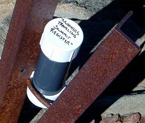 Heres a shot of the official "NWHikers Traveling Summit Register". Taken from the summit of Poe Mtn. 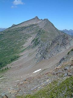 Whittier Peak as seen from the NW ridge of Longfellow Mtn. 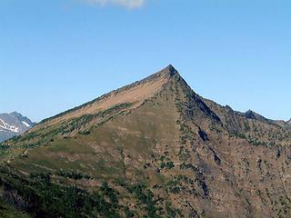 Whittier Peak as seen from the ridge between Longfellow Mtn. and Poe Mtn. 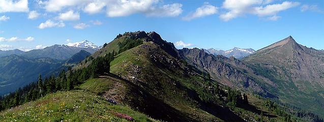 Glacier Peak-Whittier Peak Pano as seen from the ridge between Longfellow Mtn. and Poe Mtn.
|
| Back to top |
 
|
|
Jeff R
Closet hiker.

Joined: 10 Apr 2005
Posts: 972 | TRs | Pics
Location: Everret |
|
Jeff R
Closet hiker.
|
 Sun Jul 24, 2005 4:30 pm |
|
|
Nice way to set the bar, this should be a great and interesting journey.
|
| Back to top |
|
|
naturealbeing
Member
Joined: 05 Dec 2004
Posts: 1565 | TRs | Pics
Location: Great Mystery |
Hichen,
Just to verify, I did not leave the "NWHikers Traveling Summit Register". It is still in my possession and awaiting its next summit stop over.
Maybe the trip we have been planning will be its new stop over. What do you think?
|
| Back to top |
|
|
Tazz
Member

Joined: 27 Apr 2005
Posts: 7902 | TRs | Pics
|
|
Tazz
Member
|
Sun Jul 24, 2005 7:44 pm |
|
|
Thanks for the TR and great pics
I love rock NB, it sounds like Whittier is for me to put on the list with the many others. Can't wait find the NWhikers register somewhere.....out there. 
|
| Back to top |
|
|
Mike Collins
Member
Joined: 18 Dec 2001
Posts: 3096 | TRs | Pics
|
I have hiked with both Trailcat and Putz-in-Boots. Between the three of the reports on wta.org we should have been able to guide you to the top of Whittier. Although the route up to the ridge is not very friendly as it had loose rock. I connected with the west ridge 1/3 of a mile from the summit and then it was easy travelling. If you got within 250 feet then I suspect you were on a different route than I took. I was looking at Whittier on Saturday from the summits of Clark and Luahna.
|
| Back to top |
|
|
naturealbeing
Member
Joined: 05 Dec 2004
Posts: 1565 | TRs | Pics
Location: Great Mystery |
Mike,
Thanks for your positive feedback.
Please find attached a shot of the summit of Whittier, on it note a red circle. This was the highest that I got before turning around. I also tried some other areas to the left, just out of view of the picture and one other spot just right of the circle.
If the route that you used is visible in this image, could you either describe it, or edit it with a red line and repost? I'm sure that this would be helpful to others that may want to reach the summit in the future.
Thanks again for your gift of knowledge and sharing.
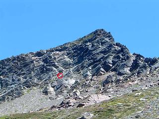 Approaching the summit of Whittier Peak. The red circle makes the highest point that I was able to reach before I turned around.
|
| Back to top |
|
|
naturealbeing
Member
Joined: 05 Dec 2004
Posts: 1565 | TRs | Pics
Location: Great Mystery |
Just a quick note:
The "NWHikers Traveling Summit Register" (or NWHTSR) has been placed. It is now on the summit of Gothic Peak. I will write up a complete report tomorrow and post it then. I would suggest that if you are going for it, as a courtesy to everyone playing, that you post your intended date, also posting upon retrieving, and again with its new placement shall be mandatory.
I wish and pray that whoever takes on the task of retrieving and replacing the NWHTSR have an incredible and safe journey.
Gothic Peak information Resources:
Summit Post: http://www.summitpost.org/show/mountain_link.pl/mountain_id/3716
WTA: http://www.wta.org/~wta/cgi-bin/wtaweb.pl?7+ds+GOTHIC%20PK+exact+trails+wta++all+3+on+browse
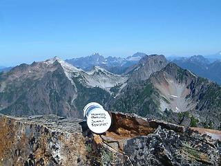 NWHTSR on summit of Gothic Pk. With the following peaks in the background, Vesper, Three Fingers, White Horse, Sperry, Big Four, and Morning Star. 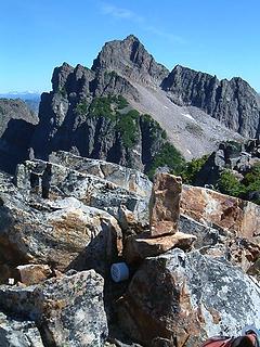 NWHTSR on summit of Gothic Peak, in its new setting, with Del Campo in the background. 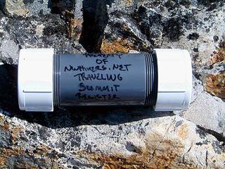 "NWHikers Traveling Summit Register"
|
| Back to top |
|
|
naturealbeing
Member
Joined: 05 Dec 2004
Posts: 1565 | TRs | Pics
Location: Great Mystery |
|
naturealbeing
Member
|
Sat Jul 30, 2005 6:29 pm Second attempt story
|
|
|
Prior to placing the NWHTSR on Gothic Peak I had made an attempt to place it with Hi-chen. Here is the story of that attempt. I include it here as part of the history of the NWHTSR stories.
When I first entertained the idea of the NWHTSR I knew that the potential for the unexpected would present some pretty interesting reading material. Well! I didnt think I would be the one supplying so much in the beginning. I thought that all I would do was pick a mountain and go place the register. On my first attempt, I wasnt able to make my objective and wound up short 200-250 ft.
Heres the story of the second attempt. Hi-chen and I had been planning a trip in the Monte Cristo area and I mentioned that we could use this opportunity to place the NWHTSR. He agreed and Tuesday was set for this mission. We reached the gate at Monte Cristo near 7:00 am and proceeded to the Sauk River crossing. Ive been across here a half dozen times and the conditions appeared to be typical. So I started to cross and about 3/4s of the way across I lost traction Upon trying to back out I was not successful and my van was just plain content with taking a river break. Maybe its tires were hot and needed some cooling off.
After some brainstorming we decided to hike back to the gate and hopefully run into someone with a cell phone with reception, or a big rig that could pull us out, or find someone to give us a ride into Silverton. Once at the gate there was no one around and we proceeded to hike down the road towards Silverton. We managed to flag down a few cars, but their cell phone reception was nonexistent.
Earlier when we drove by the Sunrise Mine Road we saw a heavy equipment truck head in. This gave me the idea that the driver would have a CB and maybe we could reach some help using it. We reached the man operating a brush cutter after a mile and a half of hiking. He said that getting a signal out of there was not possible. He did give us a ride back to his truck in the bucket of his brush cutter/loader. From there it was back to the Mtn. Loop Hwy. and westward onto Silverton. It was just after we got past Big Four when we finally got a ride in the back of a pick up and I had the driver drop us off in Silverton. He gave us a strange look when I told him that I knew some folks there and that they finally had hard lines installed and now had phone service. Well once at my friends house I found out that they were out of town and the home setter said that the lines are in but they didnt have a phone company to provide them with any services.
Upon getting back to the hwy. we soon found the sign for the sheriffs radio and another sign telling us that the radio was out of order and there was another one 2 miles down the road. It was in the next 2 miles that we were lucky to have a man pull over and give us a ride to the Verlot Ranger Station. From here it was a simple call, a ride in a tow truck and 15 minutes of work and we were free again.
I must say that this was the first time that Hi-chen and I had gotten together to do something and through all of the things that came up for us we were having a blast at making light of our situation. We were laughing pretty hard all day long.
In order to not miss out on the beautiful late afternoon that we still had left, we decided to go up and check out the Buthtab Lakes east of the summit of Pilchuck. He-chen had not been there before and even tho Crystal and I had just been up there last week, its to beautiful to pass up no matter how many times youve been there. My favorite route is the one that traverse E across the N face of Pilchuck then connects to the E ridge and then over to the BTL's. We spent the rest of the day taking in the great views on the ridge and around the lakes.
Lesson learned; expect the unexpected and pretend that it was intended, while adding lots of good humor to laugh away the day in good spirits. Having Hi-chen along to share in the experience was priceless and I look forward to enjoying his company on future trips.
Anyways the NWHTSR did not get placed "again" and would have to wait until Friday before it reached its summit stop over.
BTW, After going back out to the Monti Cristo area Friday I checked the mileage that we walked and was surprised to find out that we had done 12 miles on the roads and another 6-7 miles going up to and playing around the BTLs.
|
| Back to top |
|
|
naturealbeing
Member
Joined: 05 Dec 2004
Posts: 1565 | TRs | Pics
Location: Great Mystery |
|
naturealbeing
Member
|
Sat Jul 30, 2005 7:07 pm Gothic Peak 7.29.05
|
|
|
This is the kind of trip that Ive been thinking about sense the beginning of this game. A summit surrounded with a lot of interesting topography, along with a history, and lots of beauty to seduce the senses into believing that the energy spent was well worth the journey.
I left the TH at 7:17 and the temperature was a bit chilly first but soon warmed up as I got above the tree line. A nice steady pace kept me going strong and in an hour and fifty minutes I was at Gothic Basin. From here it was basically finding the path of least resistance to the summit. Crystal was with me today and I wanted to find the friendliest route for her to follow, but the reality was that it was going to be on a lot of lose rock and we would have to make the best of it. Last week when I took her up to the Buthtab Lakes she surprised me with how easily she scrambled and climbed over the many rocks and boulders. I thought she was getting older and had dropped her trips down a notch. Boy did she school me! As we were scrambling we would come across some patches of snow and small pools of water, this was Crystals resting, cooling off, and rehydration spa. At one such break I continued on and had to climb up and onto a rock band, when I turned to check up on Crystal, she seemed to be content to stay on a patch of snow. She could see me and knew where I was so I figured I would hook up with her on the way down. I was about 20 minutes from the summit and wanted to keep my pace up, so onward and upward I went.
Upon reaching the summit block I was reminded of what a friend had said about this section. I would have to do some climbing and there was going to be some exposure but it wouldnt be as bad as Del Campo. I found that it was straightforward and that it was pretty blocky with easy steps and plenty of handholds to keep myself secure to the mountain.
Finally reaching the summit I was now relieved in knowing that the NWHTSR was moments away form being securely placed on the summit. What came to mind was finally getting this Albatross off from around my neck. This is how it had felt like the past week and now I was soon to be free of it. I signed in on the existing register and found an appropriate location for the NWHTSR and signed it, took some pics of it on the summit, and then laid it in its new resting place.
The sun was still young in the sky and many of the surrounding peaks still had a good morning shadow on them. It sure was nice being at my objective by 10:10 am. I still had the rest of the day to play with.
While I was taking some pics of the surrounding peaks I noticed that Crystal had made her way up to the summit block and was now looking for a sweet spot to hang out. If there is a possible route to be found she will always find it and exploit it to her advantage. She never complains and is such a gift to be able to share these mountain experiences with.
After some snacks it was time to do some exploring in the basin. We made our way over to the falls and I had no idea of its existence until this day. Crystal took full advantage of the shade and took a break while I climbed up the rock face on the other side and made my way up to a rock knob above Weden Lake. The color of the lake with the surrounding rock, sky, and vegetation made for some great photographic images. Over on the opposite side up on a cliff there were 3 tents set up. Wow! What great a place to set up camp.
After wondering around and taking plenty of photos it was time to head back. The return trip was uneventful and the trip was a lot of fun and I was grateful to spend another day with Crystal in the mountains. This is as good as it gets.
Here are some random pics for your viewing pleasure, I hope you enjoy them as much as I did taking them. Theres many more posted at Flickr if you'd like to check them out.
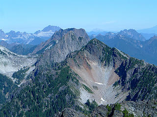 Wht. Horse, Big 4, Sperry,& Morning Star as seen from the summit of Gothic Peak. 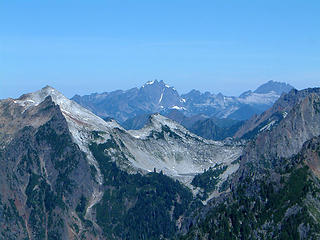 View to the N as seen from the summit of Gothic Peak. 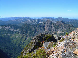 SW view from Gothic Peak as seen from the summit of Gothic Peak. 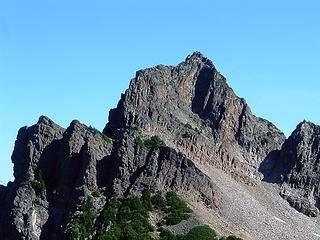 Summit of Del Campo. 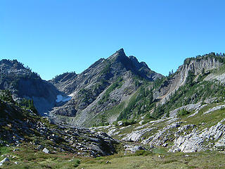 North Peak as seen from Gothic Basin. 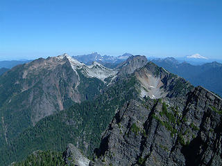 Vesper, Three Fingers, White Horse, Big Four, Sperry, Morning Star, and Mt. Baker as seen from the summit of Gothic Peak. 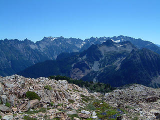 Monti Cristo Peaks & Silvertip Peak as seen from Gothis Basin. 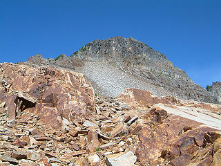 Gothic Peak as seen while on route to summit. 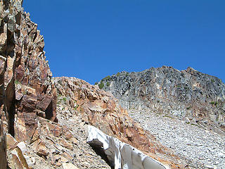 Gothic Peak summit ahead as seen while scrambling through some rock bands. 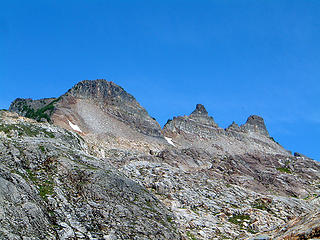 Gothic Peak & Castle Rocks as seen from the SE. 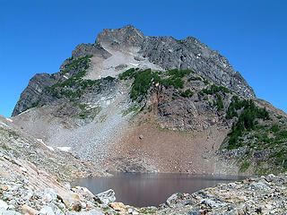 Del Campo & Foggy Lake as seen from the S. 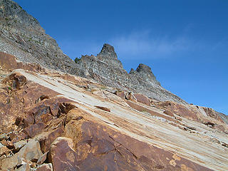 Castle Rocks as seen from the SE.
|
| Back to top |
|
|
naturealbeing
Member
Joined: 05 Dec 2004
Posts: 1565 | TRs | Pics
Location: Great Mystery |
I forgot to mention in my earlier post, that while up near the summit of Gothic Peak I came across an ice axe. It appeared to have been up there for a while, as there had been some surface rust developing on the metal surfaces. With a proper description I will be happy to make arrangements to get it back to its rightful owner.
|
| Back to top |
|
|
Tazz
Member
Joined: 27 Apr 2005
Posts: 7902 | TRs | Pics
|
|
Tazz
Member
|
Mon Aug 01, 2005 12:32 pm |
|
|
|
| Back to top |
|
|
Jeff R
Closet hiker.
Joined: 10 Apr 2005
Posts: 972 | TRs | Pics
Location: Everret |
|
Jeff R
Closet hiker.
|
Mon Aug 01, 2005 6:43 pm |
|
|
|
| Back to top |
|
|
naturealbeing
Member
Joined: 05 Dec 2004
Posts: 1565 | TRs | Pics
Location: Great Mystery |
|
| Back to top |
|
|
Stefan
Member

Joined: 17 Dec 2001
Posts: 5091 | TRs | Pics
|
|
Stefan
Member
|
Tue Aug 02, 2005 11:03 am |
|
|
Gothic. Okay. Somebody get it and place it on another peak! (I have already been up Gothic!)
|
| Back to top |
|
|
Mesahchie Mark
A Lerxst

Joined: 10 May 2005
Posts: 700 | TRs | Pics
Location: In Wonderland |
|
Mesahchie Mark
A Lerxst
|
Sun Aug 07, 2005 12:25 am Register no longer on Gothic Peak
|
|
|
The NW Hikers Summit Register is now in the hands of the TNAB High Council. Who knows where those nuts will put it next! (I don't trust them)  Rest assured, it will happen by 8/11.
BTW: Gothic Peak is a sweet hike!
Rest assured, it will happen by 8/11.
BTW: Gothic Peak is a sweet hike!
|
| Back to top |
|
|
|
|
You cannot post new topics in this forum
You cannot reply to topics in this forum
You cannot edit your posts in this forum
You cannot delete your posts in this forum
You cannot vote in polls in this forum
|
Disclosure: As an Amazon Associate NWHikers.net earns from qualifying purchases when you use our link(s). |


 also, Thankyou for starting the register. Great pics
 It would be neat to see it go across the way onto Del campo first, then a ridge run- visiting Whittier some day?