| Previous :: Next Topic |
| Author |
Message |
ALW Hiker
lakebagger

Joined: 27 Jul 2021
Posts: 120 | TRs | Pics
Location: Redmond, WA |
|
ALW Hiker
lakebagger
|
 Mon Jun 27, 2022 11:12 am |
|
|
Long-time lurker here, first time poster! First off, I'd like to say thanks to all the hikers and climbers who have made this site such an incredible resource. I'm on a mission to visit all the lakes in the Alpine Lakes Wilderness, and have gleaned tons of valuable info on routes and destinations from these pages.
On a very summer-like day yesterday, I visited Dingford Creek with a new hiking friend. I'd been to Hester, Horseshoe, and Goat Lakes last year, but this was my first hike up the Myrtle Lake fork. I'm looking forward to going back for the other two "Arthurian Lakes", plus several of the other lakes around Myrtle. I'll probably do this as a multi-night backpack later in the season.
The Dingford Creek Road was pretty much the usual. We made it OK in my Subaru Forester, but most of the vehicles at the trailhead (about a dozen) were trucks. Some of the spots in the road seemed a little trickier than usual, though the two rocky washout areas seemed to have seen a bit of work to improve passage.
Our original plan was to hike toward Myrtle Lake, then head north up Nimue Creek to Nimue, Le Fay and Merlin Lakes. At the trailhead, we decided to visit Myrtle first, then based on conditions try for Merlin and the others.
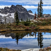
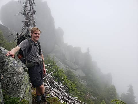
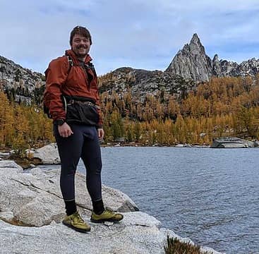
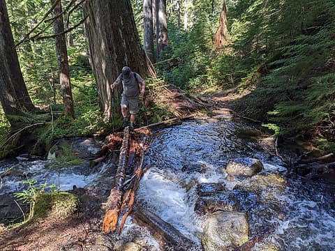 The main fork of Goat Creek was a bit spicy, but the log someone placed there works fine.  One of about 7 huge blowdowns between the Hester Junction and Myrtle Lake. We cleaned up the branches on most of them but ran out of steam on a couple. 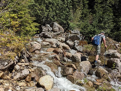 Crossing one of the many fork of Nimue Creek. It's interesting how both Nimue and Goat Creek are widely braided across the trail - must be something about the rocks or terrain in the area. 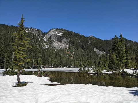 Myrtle Lake and Little Bulger 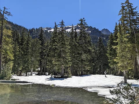 Myrtle and Big Snow Mtn 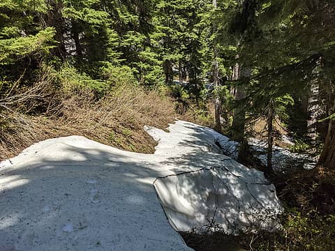 Snow bands 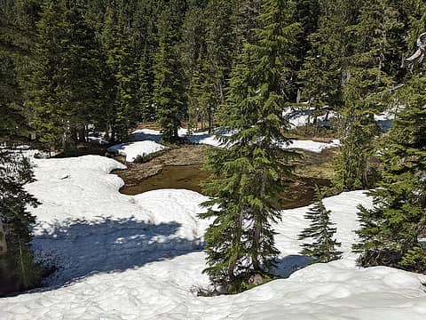 Merlin pond 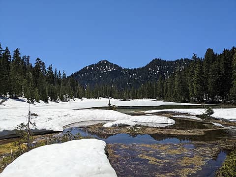 Merlin and Sorcery Mtn 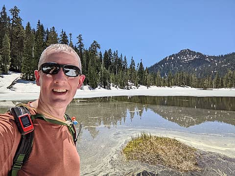 Me at Merlin 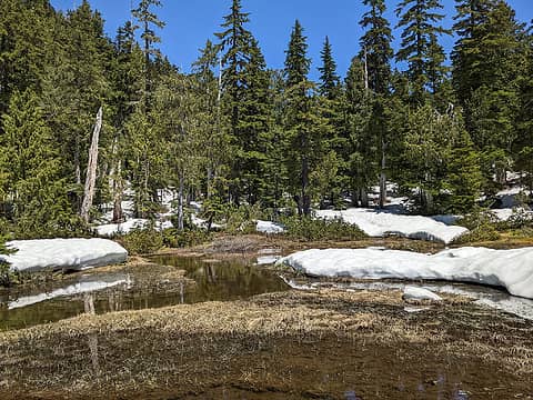 Marshy inlet 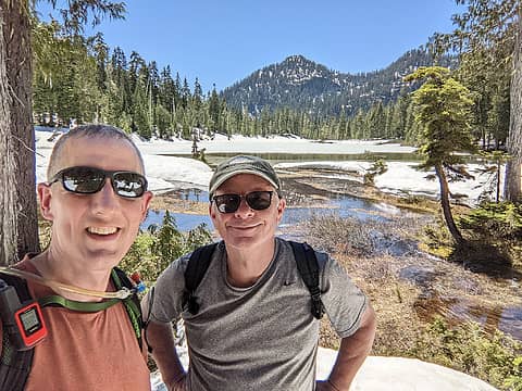 Me and Eric 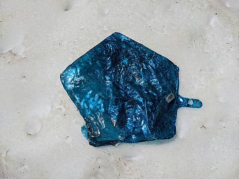 Balloon I plucked from the Merlin inlet 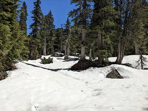 Easier terrain on the northern route 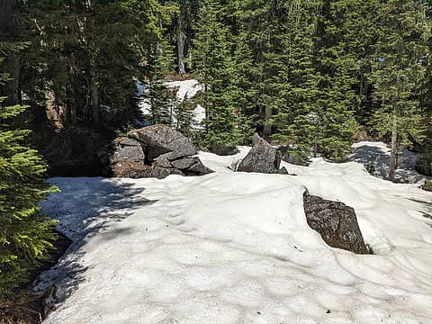 Rocks melting snow 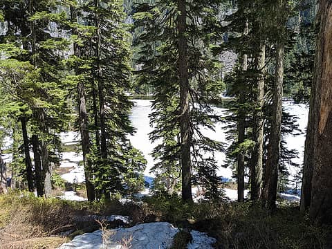 Myrtle Lake in sight 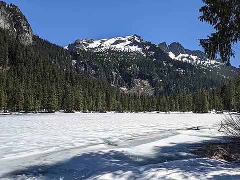 Awesome Big Snow views from the west shore 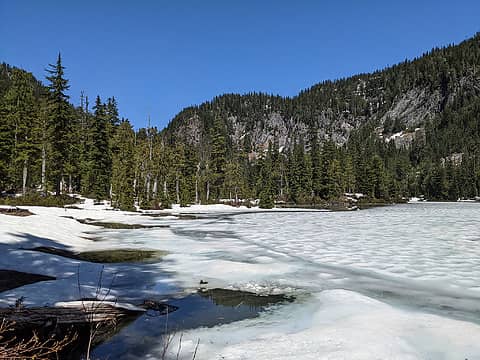 Looking toward Little Myrtle and pass to Lake Dorothy 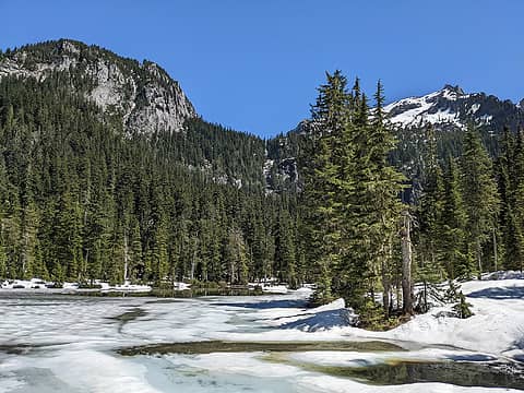 Big Snow 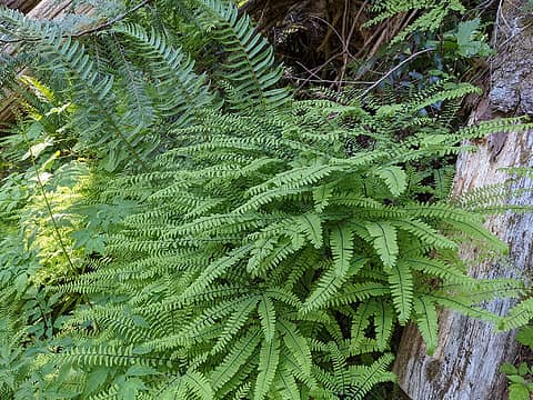 Maidenhair below Pumpkinseed Falls
 zimmertr, fallguy, wyattmullen, Now I Fly, JimK, jaysway, Nancyann, Bramble_Scramble, RichP, gumby, reststep, Slim zimmertr, fallguy, wyattmullen, Now I Fly, JimK, jaysway, Nancyann, Bramble_Scramble, RichP, gumby, reststep, Slim  awilsondc awilsondc
zimmertr, fallguy, wyattmullen, Now I Fly, JimK, jaysway, Nancyann, Bramble_Scramble, RichP, gumby, reststep, Slim awilsondc |
| Back to top |
  
|
|
Roly Poly
Member

Joined: 02 Jan 2013
Posts: 713 | TRs | Pics
|
Excellent report! A tough 13 miles in the heat! So that log crossing was a little tricky?
|
| Back to top |
|
|
Bluebird
suffering optional

Joined: 22 Jan 2014
Posts: 199 | TRs | Pics
Location: United States |
|
Bluebird
suffering optional
|
Mon Jun 27, 2022 12:54 pm |
|
|
I have a similar goal, about 185 lakes visited so far and no idea of how many I have left!
ALW Hiker
ALW Hiker |
| Back to top |
|
|
Type E
Member

Joined: 19 Aug 2006
Posts: 1381 | TRs | Pics
|
|
Type E
Member
|
Mon Jun 27, 2022 1:09 pm |
|
|
Fun area! Great now I have to count how many I have gone to and have another list to fill
E
|
| Back to top |
|
|
RichP
Member

Joined: 13 Jul 2006
Posts: 5634 | TRs | Pics
Location: here |
|
RichP
Member
|
Mon Jun 27, 2022 1:18 pm |
|
|
Welcome over here. I've seen your reports on WTA. Do you know how many lakes there are in the ALW? Probably with all the tanks, pots and tarns I'd imagine in the 100's!
|
| Back to top |
|
|
ALW Hiker
lakebagger
Joined: 27 Jul 2021
Posts: 120 | TRs | Pics
Location: Redmond, WA |
|
ALW Hiker
lakebagger
|
Mon Jun 27, 2022 1:43 pm |
|
|
| Roly Poly wrote: | | Excellent report! A tough 13 miles in the heat! So that log crossing was a little tricky? |
The log crossing wasn't as hard as it looked. The log was small but pretty stable, and I walked over it without poles on the way back.
|
| Back to top |
|
|
Kim Brown
Member
Joined: 13 Jul 2009
Posts: 6899 | TRs | Pics
|
Neat goal for sure;
How far into your goal are you!
"..living on the east side of the Sierra world be ideal - except for harsher winters and the chance of apocalyptic fires burning the whole area."
Bosterson, NWHiker's marketing expert
ALW Hiker
"..living on the east side of the Sierra world be ideal - except for harsher winters and the chance of apocalyptic fires burning the whole area."
Bosterson, NWHiker's marketing expert
ALW Hiker
|
| Back to top |
|
|
ALW Hiker
lakebagger
Joined: 27 Jul 2021
Posts: 120 | TRs | Pics
Location: Redmond, WA |
|
ALW Hiker
lakebagger
|
Mon Jun 27, 2022 2:01 pm |
|
|
| RichP wrote: | | Do you know how many lakes there are in the ALW? Probably with all the tanks, pots and tarns I'd imagine in the 100's. |
For my goal, I'm using the 2016 USFS map, adjusted for the 2014 expansion, and only counting the named lakes. There are 299 of them. Some names include multiple lakes (e.g. Rampart Lakes, Park Lakes, Thunder Mountain Lakes), but for my list I only count those as one. I am pretty sure the number is over 700 if you count all of the individual lakes, tarns, pots, etc. However, I haven't bothered to do that tally.
I have currently been to 87 out of 299, so I have quite a few left!
Some of the named lakes are pretty questionable now (Squitch and Yvonne come to mind), whereas some big ones aren't official (Pea Soup, Iron Cap, Lake 5180 SE of Summit Chief, etc.).
zimmertr, RichP
zimmertr, RichP |
| Back to top |
|
|
Backpacker Joe
Blind Hiker

Joined: 16 Dec 2001
Posts: 23956 | TRs | Pics
Location: Cle Elum |
Its been years since I was there. Nice to "See" it again. Thanks. 
"If destruction be our lot we must ourselves be its author and finisher. As a nation of freemen we must live through all time or die by suicide."
Abraham Lincoln
ALW Hiker
"If destruction be our lot we must ourselves be its author and finisher. As a nation of freemen we must live through all time or die by suicide."
Abraham Lincoln
ALW Hiker
|
| Back to top |
|
|
puzzlr
Mid Fork Rocks

Joined: 13 Feb 2007
Posts: 7220 | TRs | Pics
Location: Stuck in the middle |
|
puzzlr
Mid Fork Rocks
|
Mon Jul 04, 2022 1:49 pm |
|
|
I've never been to Merlin or Nimue lakes -- you inspire me to think about getting up there this summer. I don't mind brush in the unlogged areas so much as long as there isn't Devil's Club involved. But that grows mostly in the creek beds.
This is not directly comparable because only part of it is the Alpine Lakes Wilderness, but over the years I've been marking every lake, pond, tarn, etc that I see on Google Earth and in person within the boundaries of the Middle Fork watershed. I think I've got most of them now but every once in a while I spot another small unnamed one while trip planning. I've got 121 named lakes (official and informal names) and 258 unnamed "lakes" for this area. It's interesting that there are lakes all over most of the area but very few near North Bend. The lake has to drain into the Middle Fork to count so ones like Crater and Rachor on the north side of Si don't count.
BTW, I've got a two volume set of Lakes Of Washington that I'd like to find a new home for. If you're interested, PM me and we'll figure out how to get them to you.
|
| Back to top |
|
|
Bramble_Scramble
Member
Joined: 28 Dec 2012
Posts: 312 | TRs | Pics
|
|
| Back to top |
|
|
ALW Hiker
lakebagger
Joined: 27 Jul 2021
Posts: 120 | TRs | Pics
Location: Redmond, WA |
|
ALW Hiker
lakebagger
|
Mon Jul 04, 2022 7:51 pm |
|
|
Thanks puzzlr, that's a really interesting map you have of the Middle Fork Lakes. It's amazing how many there are, especially when you start looking at the unnamed ones. What program are you using to draw that map? It seems that some of the named lakes are not showing but maybe that's just a display/zoom issue.
The informal names are especially fun to know - I see some on there that I've never heard of, e.g. "Blackwater Lake" - behind the Hardscrabble Horse Camp?
I have the officially named ones that are part of the ALW in a spreadsheet - I'll attach it below in case people are interested. I do see a few that aren't shown on your map, so maybe my list will be helpful to you.
Named ALW lakes: https://docs.google.com/spreadsheets/d/1DXpeBOuzL3GWc-6L3-yLZ7Z1aGRWmHoV/edit?usp=sharing&ouid=105157172090315618927&rtpof=true&sd=true
We didn't see much Devil's Club on our route to Merlin, but a lot of it was under snow so it's hard to say for certain. I suspect there might be more brush if you followed the creek route up to Nimue.
|
| Back to top |
|
|
puzzlr
Mid Fork Rocks
Joined: 13 Feb 2007
Posts: 7220 | TRs | Pics
Location: Stuck in the middle |
|
puzzlr
Mid Fork Rocks
|
Mon Jul 04, 2022 9:46 pm |
|
|
That map is Google Earth with Placemarks on the lakes. I didn't mean for it to be readable at that zoom level, just leave the impression of a lot of lakes.
That's a fun list. It looks like the color coding is based on the elevation.
Yes, Blackwater is what the local crystal miners call the small lake near Hardscrabble Creek, above the horse camp. I've been all around there but never close enough to see the actual lake. I don't think it's very pretty.
Bramble_Scramble, thanks for the link to the digital versions -- now I really don't need the physical ones. It's too bad the pages are just images, with no OCR done to get an embedded text layer.
|
| Back to top |
|
|
zimmertr
TJ Zimmerman
Joined: 24 Jun 2018
Posts: 1224 | TRs | Pics
Location: Issaquah |
|
zimmertr
TJ Zimmerman
|
Mon Jul 04, 2022 9:53 pm |
|
|
Puzzlr, would you consider exporting that data and sharing it with me? I'd like to take a look through it in Google Earth.
|
| Back to top |
|
|
puzzlr
Mid Fork Rocks
Joined: 13 Feb 2007
Posts: 7220 | TRs | Pics
Location: Stuck in the middle |
|
puzzlr
Mid Fork Rocks
|
Mon Jul 04, 2022 9:58 pm |
|
|
|
| Back to top |
|
|
|
|
You cannot post new topics in this forum
You cannot reply to topics in this forum
You cannot edit your posts in this forum
You cannot delete your posts in this forum
You cannot vote in polls in this forum
|
Disclosure: As an Amazon Associate NWHikers.net earns from qualifying purchases when you use our link(s). |


