GaliWalker
Have camera will use


Joined: 10 Dec 2007
Posts: 4930 | TRs | Pics
Location: Pittsburgh |
|
GaliWalker
Have camera will use
|
 Sun Jul 03, 2022 12:55 pm |
|
|
Spruce Knob, the highest point of West Virginia (4,863ft), had never been that interesting to me because it's a spot one can drive up to. I went the once to the treed summit, where a lookout tower provides a limited view across the tops of the trees, and then never returned. Seneca Creek on the other hand, which lies just a couple of thousand feet below the summit, is a hiking destination I've visited numerous times. Seneca Creek has multiple access points, one of which involves dropping down Spruce Knob's flanks from its summit via the Huckleberry Trail. I decided it was high time I made a return trip to Spruce Knob and then hiked down the Huckleberry Trail, which was one of the few in the area I had yet to tackle. Two birds with one stone and all that.
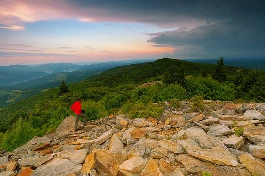
After a 4hr drive from Pittsburgh, I reached Spruce Knob around 5:45am. The drive had featured an impressively intimidating section of thunderstorm activity. Thankfully, I'd left the worst of it behind, but distant thunder still rumbled, an ominous undercurrent to the soft early morning light. As I got out of the car to walk the 0.1mi distance to the Spruce Knob summit lookout tower, I glanced at the map at the trailhead: I noticed that the trail map described a 0.5mi loop, complete with three viewpoints, none of which I remembered. All of these lay further along from the lookout tower. It seemed that I'd only gone to the tower and back, on my previous visit. More enthusiastically that I'd expected, I walked over to the lookout, climbed up to the top, just to tick off the highpoint, and then continued along the trail. Almost immediately, I was treated to a nice view towards the west. The next viewpoint was even nicer; over 180° of mountain goodness, spoilt only a little bit by a radio tower a short distance away to the southwest. Lightning flashed amidst angry dark clouds towards the west, but the skies were clearer towards the east and filled with diffuse sunshine. After a bit, it started to drizzle, so I headed back to the parking lot, only taking a cursory look from the third and final west-facing viewpoint.
 1  2  3 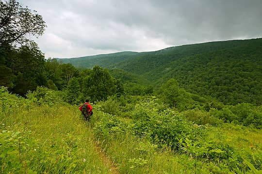 4  5  6  7
|


