| Previous :: Next Topic |
| Author |
Message |
Zloi
Member


Joined: 30 Sep 2009
Posts: 129 | TRs | Pics
Location: Burien, haven for the helpless & homeless |
|
Zloi
Member
|
 Mon Jun 26, 2023 12:20 pm |
|
|
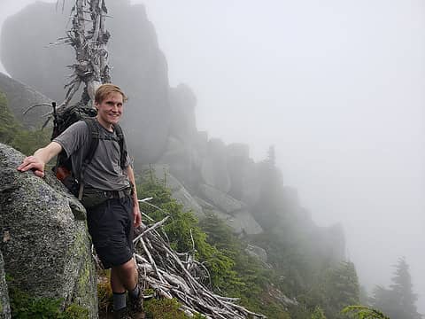
A few years ago I hiked into Bear Basin, which is a side trip from the Bare Mt trail off the N Fk Snoqualmie River Rd. There are a number of mines scattered around the basin (8 or so) and I visited only a couple then so I decided to visit a couple others and try to notch Lennox Mt as well. I backpacked into and spent the night at Bear Lake, which was pleasantly non-buggy. The adits I visited are on the way up to the lake, about 4300'. From the Bare Mt trail, you continue straight at a junction for another mile or so on an overgrown but manageable trail to where you have to hop across a stream (before that are 3 bridges in various states of decay over other streams). The adits I visited last time are straight ahead across this stream but just before it a pink ribbon marks where another trail takes off to the left. In about 200 yards it crosses the outlet stream from Bear Lake on some metal pipes and soon you come on a nice campsite. A short distance uphill from that is a boulder field with various rusting mining debris (including a steam donkey) and a couple of easily visible yellow tailings from the adits. I brought a good light with me and since the openings appeared to be in good shape, walked back a ways in each.
The hillside with mining debris and two adits (not visible but their tailings are). The waterfall on the right is the outlet from Bear Lake
Just to the right of the adit with no ore car the trail continues steeply uphill through brush to an open slope which leads to Bear Lake. The trail is not hard to follow, but make sure you mark well or memorize where you come out into the open so you can find it again if you come back down that way (you wouldn't want to bushwack that section).
Some kind of mining paraphernalia in the first adit, which had an ore car in the entrance
This adit split into 2 tunnels. The trail to the lake continues just to the right of it
Bear Lake
From Bear Lake I ascended to the obvious col and, after a short steep section, gained the ridge above the lake. From there the cirque above Lake Kanim unfolds in front of you (assuming good visibility) though the lake doesn't become visible until part-way across. Lennox is the nubbin on the ridge across.
Snow covered up most of the boulder-size rocks across this basin and made for easy travel until gaining the ridge to the false summit. That had some brushy dwarf-conifer copses that could be mostly circumvented but not completely. Once up the rocky slope to the false summit the rest of the route, above Coney Lake, is easy. It's a long day (took me >3½ hours from the lake to the summit).
Coney Lake. From pictures I've seen of it when not frozen it looks like a gorgeous alpine lake
Panorama from the top
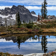
Mt Phelps and Little Phelps from the snow basin. Kanim Lake, headwaters of the N Fk, is just out of sight below the basin
Other info: FS 57 (N Fk Snoqualmie River Rd) has been greatly improved since my previous trip. Most of the gaping potholes have been gravel-filled in, at least until you get past the last river crossing. The last 3.1 mile stretch to the Bare Mt TH is a slow, taxing drive. 3-car parking space at the TH.
 Brucester, Justus S., Pef, ALW Hiker, raising3hikers, fourteen410, H. Hound, Bootpathguy, Gimpilator, John Mac, RichP, hikerbiker, mosey, day_hike_mike, Bramble_Scramble, Now I Fly Brucester, Justus S., Pef, ALW Hiker, raising3hikers, fourteen410, H. Hound, Bootpathguy, Gimpilator, John Mac, RichP, hikerbiker, mosey, day_hike_mike, Bramble_Scramble, Now I Fly  KascadeFlat KascadeFlat
Brucester, Justus S., Pef, ALW Hiker, raising3hikers, fourteen410, H. Hound, Bootpathguy, Gimpilator, John Mac, RichP, hikerbiker, mosey, day_hike_mike, Bramble_Scramble, Now I Fly KascadeFlat |
| Back to top |
  
|
|
contour5
Member

Joined: 16 Jul 2003
Posts: 2963 | TRs | Pics
|
|
contour5
Member
|
Mon Jun 26, 2023 1:41 pm |
|
|
Great trip report!
Bushwhacking from Bear Lake down to the mines is definitely a route that I would not want to repeat
|
| Back to top |
|
|
Zloi
Member
Joined: 30 Sep 2009
Posts: 129 | TRs | Pics
Location: Burien, haven for the helpless & homeless |
|
Zloi
Member
|
Mon Jun 26, 2023 4:33 pm |
|
|
I remember reading your trip report back when it was fresh. It partially inspired this trip. You had great photos and luck with running into those 2 guys. Not so lucky with the trail down which, I realized going up from the mines, was crucial to be able to locate again (and it wasn't easy even so). I almost took in the opposite direction your traverse from Bare to the col but I could see from above that the part from the basin to the Bare Mt trail looked like a wall of brush.
|
| Back to top |
|
|
1k
Member

Joined: 29 Jun 2004
Posts: 606 | TRs | Pics
Location: Ballard |
|
1k
Member
|
Mon Jun 26, 2023 5:27 pm |
|
|
| Zloi wrote: | | Mt Phelps and Little Phelps from the snow basin. Kanim Lake, headwaters of the N Fk, is just out of sight below the basin
|
Good job  I think you might have captured Kamin Lake at the bottom of you pic. Looks like it's melted out.
Life is short, hike hard...
Life is short, hike hard...
|
| Back to top |
|
|
Zloi
Member
Joined: 30 Sep 2009
Posts: 129 | TRs | Pics
Location: Burien, haven for the helpless & homeless |
|
Zloi
Member
|
Mon Jun 26, 2023 5:33 pm |
|
|
Oh yeah, a little sliver. My eyesight--not what it used to be.
|
| Back to top |
|
|
Bramble_Scramble
Member
Joined: 28 Dec 2012
Posts: 312 | TRs | Pics
|
Great report! I've been wanting to do Lennox for years. I might try this summer but I'll wait until Coney is melted.
Is the road any worse off than usual?
Edit: sorry I missed your road conditions report when I posted this. I was able to get my Honda Fit there when I took my donkey engine photo but it sounds like that might be a bad idea now.
That donkey engine was really neat. We were looking for it but didn't find it until the way down. The day we were up there the visibility was terrible.
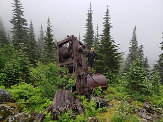 Buena Vista Mining District- donkey engine
Zloi, hikerbiker
Zloi, hikerbiker |
| Back to top |
|
|
KascadeFlat
Member
Joined: 06 Jul 2020
Posts: 314 | TRs | Pics
Location: Eating peanut M&Ms under my blue tarp |
Glad to hear they fixed up FR57 a little bit. We were up there last year in August and there was a water bar that was sketchy but navigable in high clearance 4WD (but of course we saw a Subaru with low profile tires at the TH  ). Love this area! Hope to get back there next year to get up to Coney Lake. ). Love this area! Hope to get back there next year to get up to Coney Lake.
For a good time call: 1-800-SLD-ALDR.
For a good time call: 1-800-SLD-ALDR.
|
| Back to top |
|
|
philfort
Member

Joined: 02 Sep 2003
Posts: 443 | TRs | Pics
Location: seattle |
|
philfort
Member
|
Tue Jun 27, 2023 9:34 pm |
|
|
The road up to the Bare Mtn trailhead is in pretty rough shape. I took a look on Sunday, did not feel comfortable getting past some deep ruts in my subaru, shortly after the turn off after you drive under a tree. It's also in danger of washing into the river just before that.
Hopefully they'll fix it up with the upcoming trail maintenance happening there...
|
| Back to top |
|
|
Bramble_Scramble
Member
Joined: 28 Dec 2012
Posts: 312 | TRs | Pics
|
| philfort wrote: | | Hopefully they'll fix it up with the upcoming trail maintenance happening there... |
Upcoming maintenance? I thought the FS had basically abandoned the area or is this a volunteer group?
|
| Back to top |
|
|
Zloi
Member
Joined: 30 Sep 2009
Posts: 129 | TRs | Pics
Location: Burien, haven for the helpless & homeless |
|
Zloi
Member
|
Wed Jun 28, 2023 10:43 am |
|
|
The last 3-mile section of FS 57 definitely needs help, and sooner rather than later. The first mile is the worst, with water ruts threatening to take the road out altogether. My Crosstrek struggled to get up it.
Someone has widened the Bare Mt trail after it emerges from the forest. The first mile or so, over large stones, still sucks and the Bear Basin trail would probably only be some mine-lover's project. There are a number of other mines off that FS 57 road, by the way, at least shown on maps. I'm curious who built the road out to them originally, since the mines well precede the CCC construction era. I am in awe of all the hard work those miners put in and, in most cases, for little gain.
|
| Back to top |
|
|
H. Hound
Member

Joined: 09 May 2003
Posts: 1205 | TRs | Pics
Location: Exit 32 |
|
H. Hound
Member
|
Wed Jun 28, 2023 4:19 pm |
|
|
Fun area to explore, thanks for the report. Only ever found 4 open Adit's of any length (6 & 7, and I think 3 & 4?), that and a few short prospects. In spring time the mill site is fun to poke around.
|
| Back to top |
|
|
philfort
Member
Joined: 02 Sep 2003
Posts: 443 | TRs | Pics
Location: seattle |
|
philfort
Member
|
Wed Jun 28, 2023 6:54 pm |
|
|
How's the Lennox creek trail, the one that goes up the basin to the ridge above Otter falls? I can clearly see traces of it above treeline, but what's it like below treeline? Brush bash?
|
| Back to top |
|
|
ALW Hiker
lakebagger
Joined: 27 Jul 2021
Posts: 120 | TRs | Pics
Location: Redmond, WA |
|
ALW Hiker
lakebagger
|
Fri Jun 30, 2023 6:01 am |
|
|
| Bramble_Scramble wrote: | | philfort wrote: | | Hopefully they'll fix it up with the upcoming trail maintenance happening there... |
Upcoming maintenance? I thought the FS had basically abandoned the area or is this a volunteer group? |
WTA has a four-day work party up there next month: https://www.wta.org/volunteer/schedule/workparty/a2m2K00000AWj65/
From the project description: "It has been a while since Bare Mountain has seen some trail maintenance, so we will be predominantly working on logout, tread restoration, brushing, and drainage enhancement to ensure this trail's longevity for years to come."
|
| Back to top |
|
|
ALW Hiker
lakebagger
Joined: 27 Jul 2021
Posts: 120 | TRs | Pics
Location: Redmond, WA |
|
ALW Hiker
lakebagger
|
Fri Jun 30, 2023 6:17 am |
|
|
| philfort wrote: | | How's the Lennox creek trail, the one that goes up the basin to the ridge above Otter falls? I can clearly see traces of it above treeline, but what's it like below treeline? Brush bash? |
I wouldn't call it a brush bash. I was up there in June last year and brushed out the flat section from Bear Creek (where you park) to the original trailhead about 1.75 miles in. I believe there was supposed to be a WTA work party there last summer, but they didn't record it on the trail page, so I'm not sure it happened.
Just past the original TH there is a pretty long section where the trail is basically a creek. Then, there are a couple places where it's easy to miss a turn, as you start the switchbacks up onto Dog Mountain. If you don't see the trail for a minute or two, you're probably not on it.
In the lower switchbacks there is also a pretty sketchy and brushy section of trail with some slippery puncheons and small creek crossings, but it's manageable. Above that it's mostly in big trees until you start the long traverse across Dog Mountain toward Anderson Pass. This top part is pretty nice with meadows and ultimately big slabs and huge views. It can get a bit soggy in spots but the scenery makes up for it!
philfort
philfort |
| Back to top |
|
|
Kascadia
Member
Joined: 03 Feb 2014
Posts: 651 | TRs | Pics
|
|
Kascadia
Member
|
Sat Jul 01, 2023 6:50 pm |
|
|
| philfort wrote: | | shortly after the turn off after you drive under a tree |
Is this something a "regular" Tacoma 4x4 could get under? Or are we going to have to take my Prius?
It is as though I had read a divine text, written into the world itself, not with letters but rather with essential objects, saying:
Man, stretch thy reason hither, so thou mayest comprehend these things. Johannes Kepler
It is as though I had read a divine text, written into the world itself, not with letters but rather with essential objects, saying:
Man, stretch thy reason hither, so thou mayest comprehend these things. Johannes Kepler
|
| Back to top |
|
|
|
|
You cannot post new topics in this forum
You cannot reply to topics in this forum
You cannot edit your posts in this forum
You cannot delete your posts in this forum
You cannot vote in polls in this forum
|
Disclosure: As an Amazon Associate NWHikers.net earns from qualifying purchases when you use our link(s). |


