| Previous :: Next Topic |
| Author |
Message |
mossbackmax
Member


Joined: 18 Sep 2018
Posts: 7 | TRs | Pics
Location: whitecaps (of salt) to whitecaps (of snow) |
Hello!
This is my first trip report on nwhikers, so please forgive any technical/formatting fumbling.
 "I wear a Devils Club crown, I sit upon a Slide Alder throne" 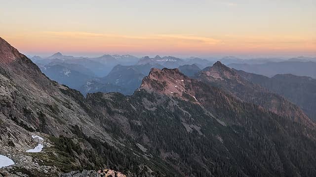 Enough alpine scenery to fill three Switzerlands 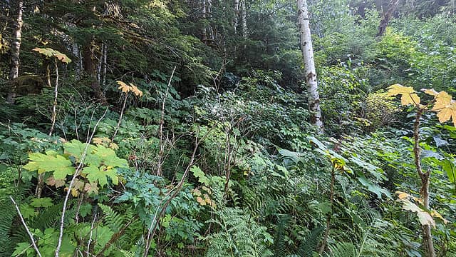 "this way looks as good as any"  Peek a Boo - 10.2 mi, 3800 gain
- 0.0 - 4.2 mi - Boulder River trail to Boulder Ford Camp, begin traveling upriver
- 4.2 - 5.1 - XC on riverbanks (we crossed back and forth ~6 times) until big logjam
- 5.1 - 6.4 mi - 1300 vertical feet of classic sub-alpinism. Id estimate grade II with the lower half BW2 and the upper half BW3+, according to the bushwack rating scale.
- 6.4 - 10.2 - Join normal Three Fingers approach. FS-4160 to Saddle Lake Camp.
Sat Aug 12 - Saddle Lake to Goat Flat, Three Fingers Summit
- 7.5 mi 3500 gain
- 0.0 - 2.2 - Move camp to Goat Flats. Yellowjacket nest next to trail around ~4700. Pit toilet in great shape, water source just below toilet trail.
- 2.2 - 4.8 - Three Fingers summit trail. Snow crossings are trivial (didnt need traction or ice axes), abundant water at 6350
- 4.8 - 7.5 - Return to Goat Flat, spectacular sunset with meteor shower afterwards.
Sun Aug 13 - Goat Flat to Three Fingers Trailhead, Meadow Mountain Trail
- 10 mi 1000 gain
- 0.0 - 3.7 - GF camp to Meadow Mountains eponymous meadows (beautiful!). No water between Saddle Lake and 3400 on Meadow Mtn switchbacks. Terrible yellowjacket nest at first switchback above Saddle Lk around
- 4020 (deadfall makes trail difficult to find here, we walked right into the nest).
- 3.7 - 7.3 - Descend Meadow Mtn switchbacks through gorgeous old growth. Meadow Mtn trail has significant blowdowns but is in much better shape than Tupso Pass to Saddle Lk trail.
- 7.3 - 9.7 - Mellow roadwalk on FS-41. The concrete bridge over S Fk Canyon Ck is not long for this world, but still easily passable on bicycles and motorcycles.
Total - 27.7 mi 8300 gain
Trip Description/Background:
(note: This report got away from me, and is definitely too long and self indulgent. But since there seems to be some interest in this route Ill leave it as is in the hope that the extra detail might someday be helpful to someone, somewhere.)
A few months ago during a Fathers Day celebration at my uncles house in the N Fk Stillaguamish Valley he and I got to talking about obscure hikes in the area. He told me about meeting a woman while hiking the Boulder River trail who told him that as a girl in the 50s she had hiked beyond Boulder Ford up to Tupso Pass and on to Three Fingers. She said that for many decades the Boulder River was the preferred access to Three Fingers, and it wasnt until the 60s or 70s that logging roads were punched far enough up Canyon Creek to justify changing the trailhead location. My uncle wondered aloud if we might be able to piece together enough scraps of that old trail to make it from Boulder Ford to Tupso Pass, and perhaps be the first people in many decades to summit Three Fingers from the Boulder River. My interest was piqued and I told him Id do some research into the feasibility of the route.
Personally, I was skeptical. Ive spent enough time thrashing up and down the valleys of the North Cascades to know that without maintenance (and sometimes even despite maintenance) trails do not last long in those temperate jungles.
Regardless, since the route from Boulder River to Three Fingers is a logical and compelling one I fully expected to find a couple trip reports of intrepid souls whod decided to schwack their way along the route of the old trail. But to my surprise I couldnt. All I could find was a couple of folks (link1, link2) who had set out with our same intention but upon failing to find more than a hint of the old trail, and nothing beyond Ditney Creek, had turned around. Another promising thread (link) made mention of some remnant trail near Tupso Pass. Additionally I was able to find the trail on some historic maps (link1, link2) and by adding them as mapsheets in caltopo was able to roughly trace where the trail might have been.
My interest was building. The idea of a route without recent documentation, climbing from an old growth valley floor to the summit of a glacially sculpted pinnacle (like a miniature version of Mt Olympus from the Hoh, with a bonus fire lookout), connecting the lowest and highest points of a beautiful wilderness, with an interesting historical aspect, was intensely compelling. I told my uncle we should go for a day hike to look around.
Reconnaissance Day Trip - July 17
A few weeks later we did just that. Entering from Boulder River we followed the route laid out in C Ps WTA trip report, linked above, looking for flagging, rusted telephone wire, and orange reflective trail blazes. For several hundred yards we followed flagging and used mental gymnastics to convince ourselves that minor changes in forest floor topography were actually old trail grade. At Ditney Creek the brush became so miserable (the pouring rain didnt help) we changed tactics and shwhacked back down to the river to reconsider, using the creek as a handrail.
From the confluence of Ditney Creek and Boulder River we decided to work our way up the river, skirting along the bank with equal parts wading and cobble hopping, until we were directly below Tupso Pass. About a mile up the river from Boulder Ford we were stopped by an enormous logjam (visible on google satellite on the south end of a large oxbow) and decided that wed done enough scouting. Wed return in a few weeks with overnight packs and plan on a three day/two night out-and-back, but with a backup plan of exiting via the normal S Fk Canyon Creek approach if the brush proved too nasty to shwhack back down.
Overnight Trip - Aug 11-13
Aug 11 - Boulder River to Saddle Lake
After an unintentionally late start we left the Boulder River trailhead around 12:30 pm. We hiked the four miles to Boulder Ford at a leisurely pace, saving energy for the bushwhack and enjoying the enormous old growth and mostly sunny skies. From Boulder Ford we hopped in the river and worked our way up the banks, crossing back and forth six or seven times, to the large floodbar on the south side of the river below the logjam and about a mile upriver from Boulder Ford Camp (side note - great camping potential on this floodbar). At 4:30 pm we dove into the brush, roughly following a broad rib between two seasonal creeks, heading South towards Tupso.
As the saying goes if youre gonna be dumb, youve gotta be tough and that sentiment perfectly encapsulates bushwhacking. While not the most difficult or lengthy bushwack, our route had a little bit of everything and was definitely full on. Comparing it to other bushwhacks Ive done Id say its easier than Beaver Pass to Eiley Wiley (though I got badly off route there) and definitely harder than Bachelor Creek. Its about equal, perhaps a bit harder, than Access Creek from Big Beaver Trail to Access Ck Basin (assuming youre able to stay on route).
At about 1800 we began to contour climbers left knowing that to continue straight up the fall line would land us in overly steep terrain and cause us to overshoot the pass. This lower section, up to around 1900, was not too bad and Id grade it BW2 according to the Bushwhack Rating Scale on Lowell Skoogs Alpenglow site. Above this the terrain steepens, and becomes solidly BW3, perhaps BW3+ in places. After a particularly strenuous section we were taking a breather on a fallen log at around 2300 when I spotted an orange reflector trail blaze. I exclaimed reflector!! and although there was no other trailsign whatsoever it gave us a much needed morale boost.
Just enough boost, in fact, to send me shwhacking right into a yellowjacket nest. Its remarkable how no matter how exhausted, how pegged at redline I might feel, hiking into a wasp nest unlocks a previously unknown reserve of energy. I crashed through the brush, zooming uphill a few hundred feet, and managed to only get stung seven times.
At 2600 we began to contour SE, climbers left, hard, to avoid the very steep area below pt 3071. As we worked our way across several swampy draws, over and under enormous old growth deadfall, I recited to myself my bushwack mantra, I wear a Devils Club crown, I sit upon a Slide Alder throne. Interestingly, the flatish area between the 2800 contour and the spur road along Tupso Pass was some of the worst brush of the entire trip, and the subjective sense was that the bushwhack was progressively clamping down harder on us the closer we got to the finish. Finally we reached the spur, badly choked with Red Alder and Vine Maple. Ratty pink flagging was a wonderful sight, and we followed the spur to FS-41 arriving just after last light.
We were quite tired (I could feel all that yellowjacket venom working inside me) and intended to camp on the road at the old trailhead where most folks lock up their bikes, but since we had consumed the last of our water we slogged in the dark to Saddle Lake and camped there, arriving around half past midnight.
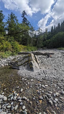 strange balanced log in Boulder River, you could move it with a finger  beginning the shwhack 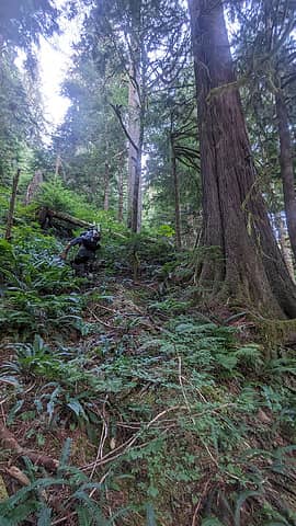 going up 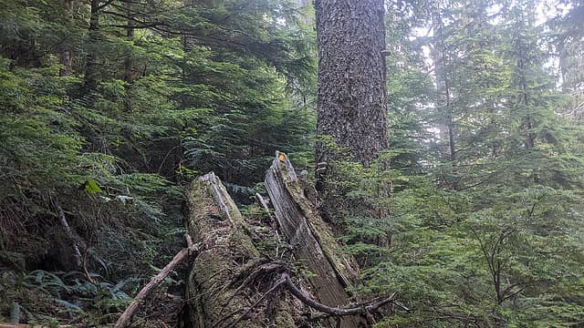 reflector at 2300' 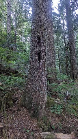 old blaze? 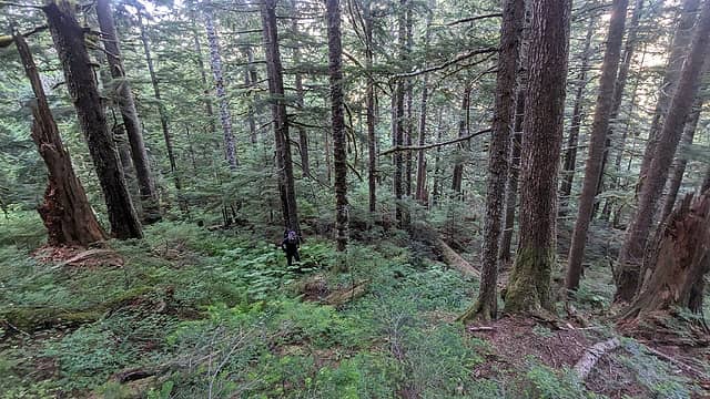 lower section  mid section  upper section  peek a boo views  at the road in the nick of time 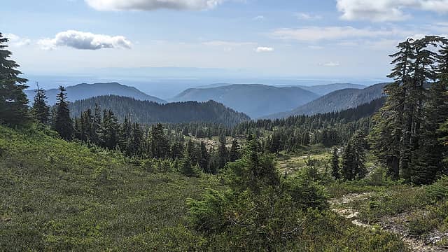 gorgeous goat flat 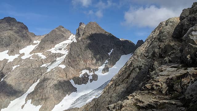 do you see it? 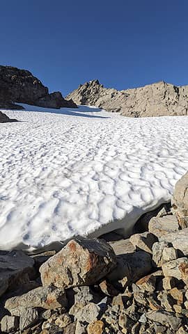 trivial (at this time of year) snowfield 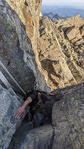 ladder scramble 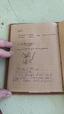 summit register 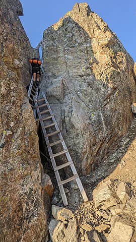 ladders 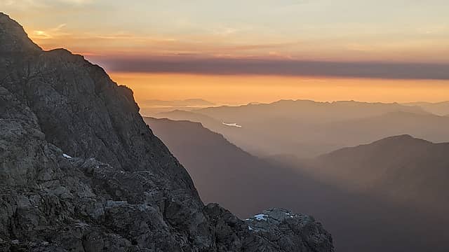 Mt Constitution, San Juans, Lk Cavanaugh 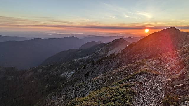 yowza 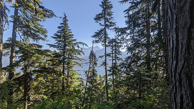 meadow mtn views 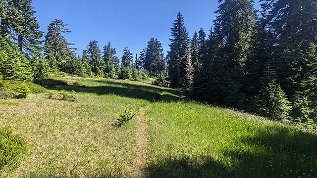 meadow mtn summit (not pictured: bugs) 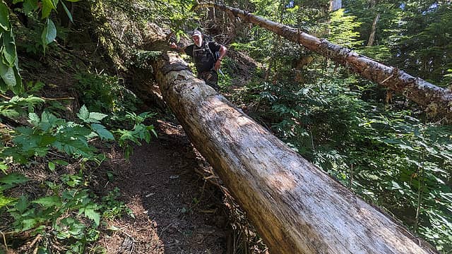 meadow mtn deadfall - Logjam - 48.20956, -121.76802
- Bushwack entry point - 48.21043, -121.76832
- Broad rib, top of small knoll - 48.20992, -121.77096
- Reflector at 2300 - 48.20565, -121.77532
- Gain spur road - 48.19916, -121.77420
- Delicious water below final snowfield - 48.16735, -121.68943
- Yellow jacket nest on Meadow Mtn trail - 48.18085, -121.75803
- Highest water on Meadow Mtn trail - 48.17247, -121.79760
Useful & Interesting Links
Final Questions
- Are there no fish in the Boulder River? I looked closely for any, even fry, and didnt see any. Not even Suckers or Rainbows.
- Whats the difference between NF-XX and FS-XX road designations? Seems like theyre used interchangeably.
- In the nwhikers thread listed above, theres mention of a shelter at the headwall of the Boulder River. Anyone have more info on this?
- In the Bates interview he mentions accessing Three Fingers from the Squire Creek side, has anyone done this? Or attempted to do this?
If you've read this far, thanks!
Best,
M
 awilsondc, ozzy, lopper, Comma, ChinookPass, BarbE, Anne Elk, Alden Ryno, contour5, hikerbiker, runup, flatsqwerl, mosey, jaysway, Waterman, fourteen410, kite, reststep, Schroder, jstern, MistyMountainHop, lovetowonder, John Mac, Now I Fly, Bramble_Scramble, jsb, Bowregard, Chief Joseph, JimK, RichP awilsondc, ozzy, lopper, Comma, ChinookPass, BarbE, Anne Elk, Alden Ryno, contour5, hikerbiker, runup, flatsqwerl, mosey, jaysway, Waterman, fourteen410, kite, reststep, Schroder, jstern, MistyMountainHop, lovetowonder, John Mac, Now I Fly, Bramble_Scramble, jsb, Bowregard, Chief Joseph, JimK, RichP
awilsondc, ozzy, lopper, Comma, ChinookPass, BarbE, Anne Elk, Alden Ryno, contour5, hikerbiker, runup, flatsqwerl, mosey, jaysway, Waterman, fourteen410, kite, reststep, Schroder, jstern, MistyMountainHop, lovetowonder, John Mac, Now I Fly, Bramble_Scramble, jsb, Bowregard, Chief Joseph, JimK, RichP |
| Back to top |
  
|
|
RichP
Member

Joined: 13 Jul 2006
Posts: 5632 | TRs | Pics
Location: here |
|
RichP
Member
|
 Thu Aug 17, 2023 9:37 pm |
|
|
Wow! That's an admirable approach to Three Fingers. I like the comparison to Olympus.
mossbackmax
mossbackmax |
| Back to top |
|
|
mossbackmax
Member
Joined: 18 Sep 2018
Posts: 7 | TRs | Pics
Location: whitecaps (of salt) to whitecaps (of snow) |
Thanks RichP!
It makes me wonder - what other feasible"lowest to highest" routes exist in WA wildernesses. Ohanapecosh to the summit of Tahoma would be one, Goodell Ck to Goode would be another - not quite sure how that route would work lol
|
| Back to top |
|
|
Gimpilator
infinity/21M

Joined: 12 Oct 2006
Posts: 1684 | TRs | Pics
Location: Edmonds, WA |
This is just awesome. Hope to see more from you in the future. 
|
| Back to top |
|
|
Schroder
Member

Joined: 26 Oct 2007
Posts: 6716 | TRs | Pics
Location: on the beach |
|
Schroder
Member
|
Fri Aug 18, 2023 8:26 am |
|
|
lopper, pula58, ChinookPass, mossbackmax |
| Back to top |
|
|
fourteen410
Member

Joined: 23 May 2008
Posts: 2628 | TRs | Pics
|
Incredible first trip report here!
mossbackmax
mossbackmax |
| Back to top |
|
|
mossbackmax
Member
Joined: 18 Sep 2018
Posts: 7 | TRs | Pics
Location: whitecaps (of salt) to whitecaps (of snow) |
Thanks for the encouraging comments y'all!
|
| Back to top |
|
|
Kim Brown
Member

Joined: 13 Jul 2009
Posts: 6899 | TRs | Pics
|
I read every word! Great report; it's more interesting to be a half-crazy person than a sane one, no? Makes a great trip report, too.
I have found 2 insulators on the Boulder River trail between the trail head & Feature Show Falls.
I wonder how old the reflector is - can't be too old, so it seems someone, at some time, wanted to keep the original route alive. That seems to happen when trails close.
"..living on the east side of the Sierra world be ideal - except for harsher winters and the chance of apocalyptic fires burning the whole area."
Bosterson, NWHiker's marketing expert
mossbackmax
"..living on the east side of the Sierra world be ideal - except for harsher winters and the chance of apocalyptic fires burning the whole area."
Bosterson, NWHiker's marketing expert
mossbackmax
|
| Back to top |
|
|
Route Loser
Member
Joined: 24 Jul 2012
Posts: 199 | TRs | Pics
Location: Whidbey Island |
Sounds like a good time. Thanks for the report.
There are fish.
Walking over from Squire Creek Pass is fun with modest scrambling. There are good approaches further north on Squire Creek, depending on which summit you are aiming for.
There are much more direct approaches from the S.
ozzy  mossbackmax mossbackmax
ozzy mossbackmax |
| Back to top |
|
|
mossbackmax
Member
Joined: 18 Sep 2018
Posts: 7 | TRs | Pics
Location: whitecaps (of salt) to whitecaps (of snow) |
I fully agree, Kim. Much more interesting.
Are those insulators used for telephone or telegraph wires? I've heard about lookouts "calling in" fires, which makes me think telephone, but perhaps they used portable radios? I'll have to see if I can't find a book or two about the daily lives and protocols of fire lookouts.
As for the reflectors, we were thinking the same thing. They looked old, but more on the order of decades than a century. There were also also occasional reflectors on trees and rocks between Tupso and Three Fingers, though most of those were red instead of orange.
Route Loser thanks for the additional info. The route from Squire Ck Pass looks interesting, possibly could combine it with a traverse from Big Bear to Three Fingers. I'd imagine as well that Squire Ck is the approach for Craig and Bullon Lakes, correct?
The direct South approach you mention, does that go up Baldy Ck? Or from Windy Pass?
I really appreciate the info, looks like maybe Squire Ck might be next for me.
|
| Back to top |
|
|
Schroder
Member
Joined: 26 Oct 2007
Posts: 6716 | TRs | Pics
Location: on the beach |
|
Schroder
Member
|
Fri Aug 18, 2023 11:39 am |
|
|
Someone has done the ramp, shown snow covered here, from Squire Creek. I think they reported their trip on the forum.
A short approach to Goat Flats existed back in the 70's when the road was closed for several years. It went from the Canyon Creek bridge directly north up a ridge and took you straight to the middle of the flats.
Approximately here
It wasn't too brushy as I remember
mossbackmax
mossbackmax |
| Back to top |
|
|
Route Loser
Member
Joined: 24 Jul 2012
Posts: 199 | TRs | Pics
Location: Whidbey Island |
| mossbackmax wrote: | | I'd imagine as well that Squire Ck is the approach for Craig and Bullon Lakes, correct? |
Well, the most romantic approach to the lakes would be to continue your route up the Boulder River. But yes, heading up from Squire Creek in the general direction of Salish is more sensible.
| mossbackmax wrote: | | The direct South approach you mention, does that go up Baldy Ck? Or from Windy Pass? |
I haven't gone up from Windy Pass or the climber's trail to Green Giant Buttress, but it would likely be wholesome fun.
I feel like the standard S approach is becoming a sekrit in the gpx era. Beckey must be passé. But since you are gathering all this info, it goes up a rib next to Sevenmile creek. There are some fixed ropes on it and occasionally someone will flag it. All the S ribs more or less go with more or less 4th class forest. Beckey didn't choose the prettiest rib.
I bet straight up Baldy Creek would be really lovely.
mossbackmax
mossbackmax |
| Back to top |
|
|
Schroder
Member
Joined: 26 Oct 2007
Posts: 6716 | TRs | Pics
Location: on the beach |
|
Schroder
Member
|
Fri Aug 18, 2023 12:16 pm |
|
|
| Route Loser wrote: | | I feel like the standard S approach is becoming a sekrit in the gpx era. Beckey must be passé. But since you are gathering all this info, it goes up a rib next to Sevenmile creek. There are some fixed ropes on it and occasionally someone will flag it. All the S ribs more or less go with more or less 4th class forest. Beckey didn't choose the prettiest rib. |
I went up it many times and certainly never encountered terrain that required fixed lines
lopper, Route Loser
lopper, Route Loser |
| Back to top |
|
|
Kim Brown
Member
Joined: 13 Jul 2009
Posts: 6899 | TRs | Pics
|
| mossbackmax wrote: | | Are those insulators used for telephone or telegraph wires? I've heard about lookouts "calling in" fires, which makes me think telephone, |
Phone wires. Early days, a phone unit with a battery was hauled up to the lookout; these things were up to 80 pounds, and the very early lookouts hauled them up on their backs - plus their gear. My guess is that if a pack mule didn't take it to the lookout site, the mule dropped the pile of goods at a certain point, then the lookout finished it himself (they do that today as well; I have seen it at Miner's Ridge).
When a lookout needed to make a call, he'd haul the phone to the nearest wire (laying on the ground at that location) and connect it with a wire on the unit to make the call. Often, a tree would topple and break the wire, which meant the lookout, on top of regular duties, would have to trace the wire to the break, mend it, then make the call.
A good book to read is Andy Holland's "Switchbacks." He details several aspects of being a lookout in the early 30's at Miner's Ridge and Circle Peak. It was recommended to me several years ago by JimK, and in turn, I recommend it time and again here.
I am thankful I was born when I was, and not much before; I am too lazy to have survived.
"..living on the east side of the Sierra world be ideal - except for harsher winters and the chance of apocalyptic fires burning the whole area."
Bosterson, NWHiker's marketing expert
Bramble_Scramble, mossbackmax
"..living on the east side of the Sierra world be ideal - except for harsher winters and the chance of apocalyptic fires burning the whole area."
Bosterson, NWHiker's marketing expert
Bramble_Scramble, mossbackmax
|
| Back to top |
|
|
Route Loser
Member
Joined: 24 Jul 2012
Posts: 199 | TRs | Pics
Location: Whidbey Island |
| Schroder wrote: | | I went up it many times and certainly never encountered terrain that required fixed lines |
The fixed lines are absolutely unnecessary. But they exist as of a few years ago on a line drawn from Sevenmile where it crosses the road and intersecting your line above at 4,000. I guess there wasn't enough brush for some people to hang onto.
|
| Back to top |
|
|
|
|
You cannot post new topics in this forum
You cannot reply to topics in this forum
You cannot edit your posts in this forum
You cannot delete your posts in this forum
You cannot vote in polls in this forum
|
Disclosure: As an Amazon Associate NWHikers.net earns from qualifying purchases when you use our link(s). |


