| Previous :: Next Topic |
| Author |
Message |
ALW Hiker
lakebagger

Joined: 27 Jul 2021
Posts: 120 | TRs | Pics
Location: Redmond, WA |
|
ALW Hiker
lakebagger
|
 Wed May 03, 2023 8:17 pm |
|
|
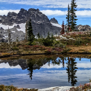
We visited Sunday Lake yesterday for the first time - fun trip!
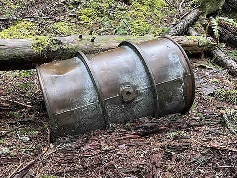
On the way back we noticed the old logging (or mining) camp just south of the creek ford. Not sure how we missed it on the way in, as all the rusting barrels are like 15' off the trail.
Anyway, there is a lot of old stuff there but these two vehicles seemed pretty interesting to me. Can anyone provide a positive identification?
This appears to be a tracked trailer of some sort. It has a hitch on the back and a trailer tongue on the front.
This one appears to be a pickup truck or utility truck. It has a fold-down front windshield and apparently mounts for spare tires behind the front doors on both sides.
 ree, zeldathewelder, Bramble_Scramble, KascadeFlat ree, zeldathewelder, Bramble_Scramble, KascadeFlat  Brucester Brucester
ree, zeldathewelder, Bramble_Scramble, KascadeFlat Brucester |
| Back to top |
  
|
|
catsp
Member
Joined: 15 Jun 2017
Posts: 225 | TRs | Pics
|
|
catsp
Member
|
Wed May 03, 2023 10:11 pm |
|
|
Brucester, zeldathewelder, Bramble_Scramble, Seventy2002, ALW Hiker, RichP |
| Back to top |
|
|
catsp
Member
Joined: 15 Jun 2017
Posts: 225 | TRs | Pics
|
|
catsp
Member
|
Thu May 04, 2023 10:11 am |
|
|
zeldathewelder |
| Back to top |
|
|
Seventy2002
Member

Joined: 19 Jul 2008
Posts: 512 | TRs | Pics
|
The utility vehicle looks like a Dodge WC-6 or variant.
Brucester
Brucester |
| Back to top |
|
|
Dick B
Member
Joined: 06 Jun 2013
Posts: 345 | TRs | Pics
Location: Redmond, Or |
|
Dick B
Member
|
Thu May 04, 2023 11:36 am |
|
|
Good catch on the command car. The spare tire location seems to be a giveaway. Also the posted speed on the dash would likely make it a military vehicle. I drove a 3/4 Dodge truck for a mortar squad in Germany in the late 50s/early 60s. I seem to remember that the posted speed for that vehicle was 35 MPH, Imagine driving on the autobahn at that speed. Most of the travels were in multivehicle convoys so no big deal. Sure took a long time to get from A to B tho. I also got to drive a jeep for the platoon leader and company commander toward the end of my tour. That was more fun except in the cold and rain since they were never covered. That was not much fun.
|
| Back to top |
|
|
ALW Hiker
lakebagger
Joined: 27 Jul 2021
Posts: 120 | TRs | Pics
Location: Redmond, WA |
|
ALW Hiker
lakebagger
|
Thu May 04, 2023 3:14 pm |
|
|
Awesome info, thanks everyone! It's really fun to see pictures of what the vehicles would have looked like in proper working condition.
I learned two new terms - "crawler wagon" and "command car". They certainly seem like good vehicles to have on poor roads in the middle of the forest.  We figured both vehicles were probably WWII surplus. We figured both vehicles were probably WWII surplus.
zeldathewelder
zeldathewelder |
| Back to top |
|
|
Waterman
Member
Joined: 21 Mar 2015
Posts: 590 | TRs | Pics
Location: Big Snow Quadrangle |
|
Waterman
Member
|
Thu May 04, 2023 6:24 pm |
|
|
The most I ever find is old logging cables and rusty metal.
Way cool find.
Two roads diverged in a wood, and I,I took the one less traveled by. And that has made all the difference.
Robert Frost
Two roads diverged in a wood, and I,I took the one less traveled by. And that has made all the difference.
Robert Frost
|
| Back to top |
|
|
hunterofelke
Roland
Joined: 04 Aug 2020
Posts: 26 | TRs | Pics
Location: Issaquah |
My guess that equipment was left at the timber sale site over the winter and the bridge washed out. When that happened I don't know, maybe the '50's. Funny thing I found on the King County Assessor site was a planned route for the Sunday Creek road and it went all the way to the logging roads on Rooster.
|
| Back to top |
|
|
ALW Hiker
lakebagger
Joined: 27 Jul 2021
Posts: 120 | TRs | Pics
Location: Redmond, WA |
|
ALW Hiker
lakebagger
|
Sat May 27, 2023 11:11 pm |
|
|
It's pretty bizarre that the King County GIS still has the entire Sunday Creek road in the system going up and over to Quartz Creek, even though it wasn't actually built. If you look closely, the route where they show the road passing over the ridge makes no sense - it goes straight up a steep talus slope on the south side of Rooster Mountain, and then straight down cliffs on the north face with nary a switchback to be seen.
In their Alpine Lakes Wilderness guide, Barnes & Barnes say that the Sunday Lake Trail existed at least as far back as the 1920s but only went to the north end of the lake. Then in 1953, a mining claim was filed south of the lake called the "Loch Katrine Lodes", and extended the trail south of the lake to near the location of the cabin discussed earlier in this thread. The guide also says some roads were built around the same time (1950s), and the loggers came in afterwards. No firm detail is provided about exactly how far the roads went or where they were located, though it is implied they did go up to that confluence area where the cabin is located.
I sure didn't see anything along the west side of the lake, or south of it that looked like a road cut, so I'm a bit skeptical. The 1960 and 1980 Forest Service maps show the trail going to the cabin but don't show any roads past the current creek ford. However, the 1980 map says "4WD" on the trail south of the ford, so presumably the bridge over the creek was still in then, or there was a passable road ford.
There is a lot of interesting history out there, it's fun to try and dig through it. I found this 1953 map of the Loch Katrine Lodes (among others). When I have a chance I might try to overlay it onto a current map - it shows some roads and a bunkhouse, among other things.
|
| Back to top |
|
|
|
|


