| Previous :: Next Topic |
| Author |
Message |
Sore Feet
Member


Joined: 16 Dec 2001
Posts: 6307 | TRs | Pics
Location: Out There, Somewhere |
One thing I can say about the BC trails is they certainly get to the down and dirty without pussyfooting around long tedious switchbacks and whatnot.
The High Falls Creek trail is about as burly a day hike as you'll find. Someone must have really wanted to see the falls and the extremely impressive gorge up High Falls Creek, because this one climbs up right along the gorge rim, with the aid of ropes and chains, straight up.
The trailhead is located about 16 miles up the Squamish Valley road (I don't remember the exact milage), just past the High Falls Creek bridge (signed). Park on the near side of the creek and walk down the road for about 100 feet to the trail, marked by a sign tacked to a tree.
The trail begins as a level, ex-road, which worms through second growth forest for about 10 minutes. At one point, there is a junction which heads off right and contours the cliffs you'll start climbing, ending shortly at the creek at the mouth of the gorge (a good place to soak feet after the hike). The trail is easy to miss at this point. Look for flagging. The trail actually squeezes between two trees, no more than 3 feet apart, which is why it's easy to miss. Just beyond here, the trail starts climbing straight up the cliffs, with aid of root ladders and rocks sticking out of the ground.
About 100 vertical feet later are some outstanding views over the Squamish Valley, looking across towards pencil thin-but massively tall Madden Falls and the Tantalus range. The trail continues up bare rock to a point where it literally climbs up a vertical rock face of about 7 feet, with the aid of a chain attatched to a tree above.
Above here, it enters the woods again, following a dusty path through abundand Salal bushes, and offering vertigo-inducing views 200 feet down the gorge to the creek below. The trail pretty much does this for the whole way up, bounces between bare rock climbs, and wooded salal walking. About 2/3 of the way up, the trail gets dustier and less vertical, but remains constantly pitched at a 30-40 degree angle, which gets tiring quickly.
A whole 1.25 miles from the trailhead, which seems a helluva lot longer, is the first viewpoint of the falls. The canyon here is probably 350 feet deep from the top to bottom (measuring the opposite walls at least), and at least 250 feet deep from the trail. The falls plunge out of a cleft in the rock, straight down for that 250 feet, impressive in August, I imagine it's spectacular in the spring. Just below the falls, if you have the nerve, you can look straight down to the creek, where the gorge is no more than 5 feet wide.
The trail keeps going for a short distance, and two more ropes, to a second viewpoint, offering views of the upper tier of the falls. There is a rude path that decends to a bench level with the top of the main falls, which offers a slightly better view, but it perched even more precariously at the edge of a looooong drop-off.
The trail keeps going further upstream, eventualling meating an abandoned logging road in another 2 miles, but I was done for the day, so back down I went, in half the time it took to come up.
--
On a side note, if you're looking to enjoy the scenery in the area after the hike, keep driving up the valley for another 5-6 miles to a place called "The Bayou", where the Squamish River braids through trees right next to the road, looking like something you'd see in Louisiana, only with blue glacier water.
|
| Back to top |
  
|
|
David¹
Token Canadian

Joined: 25 Jul 2002
Posts: 3040 | TRs | Pics
Location: The Great White North |
|
David¹
Token Canadian
|
 Mon Aug 19, 2002 12:53 pm |
|
|
FWIW here are a few pictures of High Falls in spring. You really can't get a 'clean' shot of the falls, and these were taken after scrambling a bit off trail. BTW you really should have done the full loop as the views are great on a clear day.
http://groups.msn.com/davidkarenshikingpage
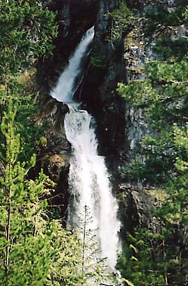 Upper High Falls 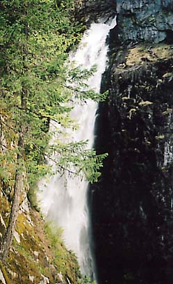 Lower High Falls
|
| Back to top |
|
|
Sore Feet
Member
Joined: 16 Dec 2001
Posts: 6307 | TRs | Pics
Location: Out There, Somewhere |
Didn't have time to go further than the falls, we had to haul ass back down to Horseshoe Bay to catch a boat over to Nanaimo. Gotta save something for next time, right? 
|
| Back to top |
|
|
Sore Feet
Member
Joined: 16 Dec 2001
Posts: 6307 | TRs | Pics
Location: Out There, Somewhere |
|
| Back to top |
|
|
|
|
You cannot post new topics in this forum
You cannot reply to topics in this forum
You cannot edit your posts in this forum
You cannot delete your posts in this forum
You cannot vote in polls in this forum
|
Disclosure: As an Amazon Associate NWHikers.net earns from qualifying purchases when you use our link(s). |


