| Previous :: Next Topic |
| Author |
Message |
awilsondc
Member


Joined: 03 Apr 2016
Posts: 1324 | TRs | Pics
|
I had a rare opportunity for a mid week backpacking trip shortly before Memorial Day. I had a trip planned (Skokomish and Stone in the Olympics) but as the day drew close it became clear that the weather was going to be poor. I went through a half dozen alternatives for the trip before checking permits for the enchantment area and turns out there was one permit left for Lake Stuart on the day I wanted. I reserved it, but in the end I decided to just scrap the overnighter in favor of a trip to Crater Lake with the family for the long weekend. I did however get in a phenomenal day trip up to Lake Stuart and Axis Peak. This is that trip:
I left the house at 4:30 and after hitting some unexpected early morning rush hour traffic, reached the Lake Stuart trailhead and was on the trail by 8:30. I made great time up the trail navigating over, under, and around several small downed trees and some snow 1/2 a mile before the lake. It took me an hour and 40 minutes to the lake where I spent 20 minutes relaxing and eating some food.
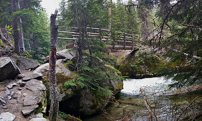 The foot bridge along the Lake Stuart trail 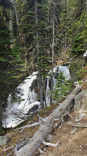 Waterfall along the Lake Stuart trail 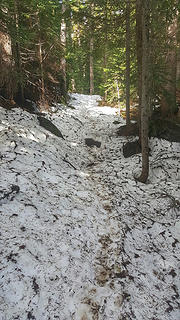 Snow starting about a half mile from Lake Stuart 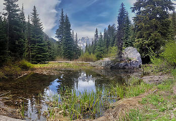 First mountain views 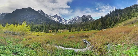 The meadow on the way to Lake Stuart 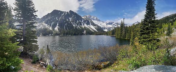 Mountaineer ridge and Mount Stuart from Lake Stuart 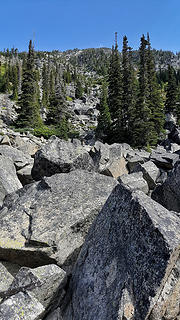 Axis Peak south face scramble route 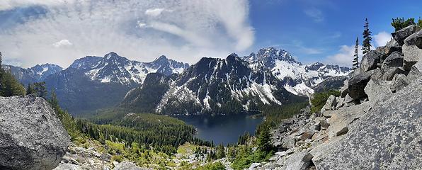 The view from half way up Axis Peak 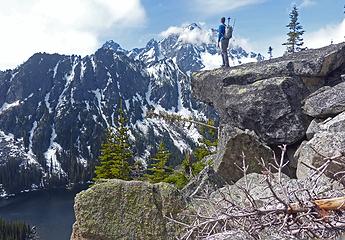 Looking at Stuart 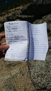 Axis Peak summit register 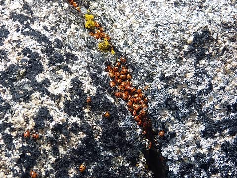 Ladybugs! 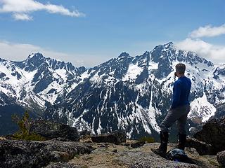 Enjoying some tea 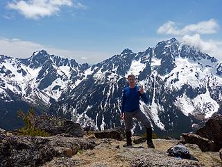 Summit Selfie 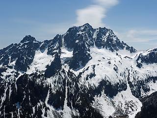 North Face of Stuart 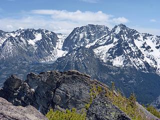 Looking at Aasgard, Dragontail, and Colchuck 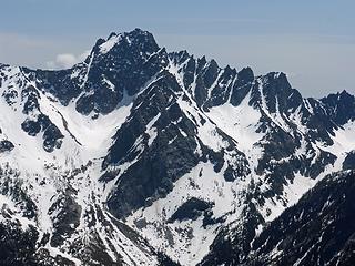 Argonaut 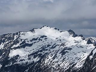 Hi-Jack Peak (Jack Ridge) 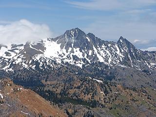 Cashmere 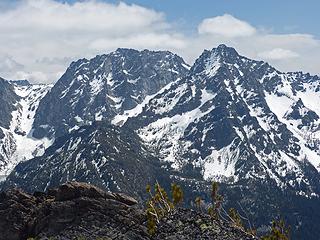 Dragontail and Colchuck 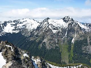 Hi-Jack and Eightmile 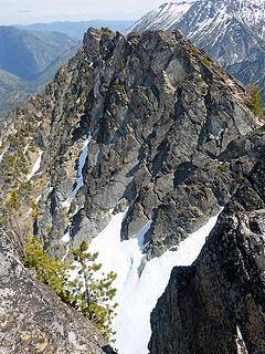 Axis Peak east ridge cliggs 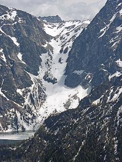 Aasgard Pass 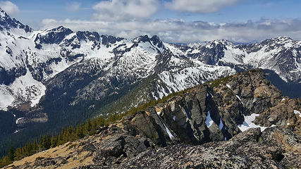 Summit of Axis Peak looking west toward Horseshoe Lake (snowy bowl upper left) 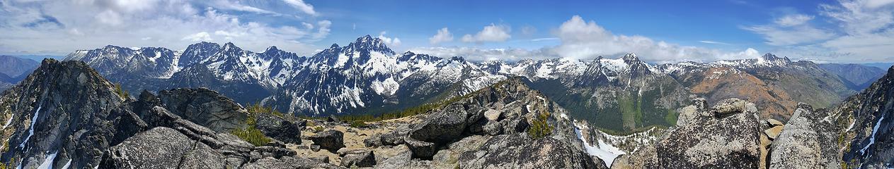 Axis Peak summit panorama 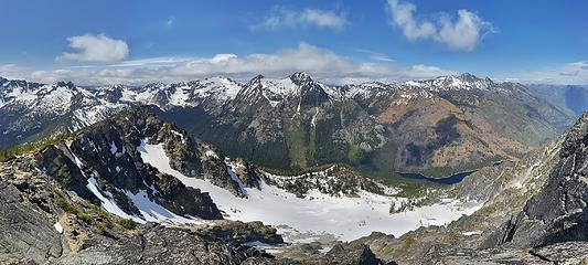 Looking north from Axis Peak
|
| Back to top |
  
|
|
mtn.climber
Member

Joined: 29 Jul 2008
Posts: 1204 | TRs | Pics
Location: The Lost Horizon |
Great beta! I'm going up there on Sunday. Hope the weather is good.
Reach for the sky, cuz tomorrow may never come.
Live the life of love. Love the life you live.
Reach for the sky, cuz tomorrow may never come.
Live the life of love. Love the life you live.
|
| Back to top |
|
|
FiveNines
Member

Joined: 01 Oct 2010
Posts: 528 | TRs | Pics
|
Fun trip. Nice panos. I like the meadow on the way to Lake Stuart.
|
| Back to top |
|
|
Distel32
Member
Joined: 03 Jun 2014
Posts: 961 | TRs | Pics
Location: Edmonds, WA |
|
Distel32
Member
|
 Fri May 27, 2016 9:04 pm |
|
|
|
| Back to top |
|
|
Magellan
Brutally Handsome

Joined: 26 Jul 2006
Posts: 13116 | TRs | Pics
Location: Inexorable descent |
|
Magellan
Brutally Handsome
|
Fri May 27, 2016 9:16 pm |
|
|
|
| Back to top |
|
|
zephyr
aka friendly hiker

Joined: 21 Jun 2009
Posts: 3370 | TRs | Pics
Location: West Seattle |
|
zephyr
aka friendly hiker
|
Fri May 27, 2016 9:37 pm |
|
|
Great report. Yes, it's a bit of work getting up there through all those boulders. Excellent choice for this time of year. Lovely views all around. As we ascended we were greeted by two Septugenarians on their way down! I was very impressed. ~z
|
| Back to top |
|
|
Nancyann
Member
Joined: 28 Jul 2013
Posts: 2322 | TRs | Pics
Location: Sultan Basin |
|
Nancyann
Member
|
Fri May 27, 2016 10:29 pm |
|
|
Those panos are absolutely gorgeous!
|
| Back to top |
|
|
Gimpilator
infinity/21M

Joined: 12 Oct 2006
Posts: 1684 | TRs | Pics
Location: Edmonds, WA |
That's a fun one. Thanks for the memories and nice job on those photos! I've wondered recently if the couloir on Mountaineer Ridge still has snow in it. Looks like it does.
|
| Back to top |
|
|
OwenT
Member

Joined: 24 May 2014
Posts: 277 | TRs | Pics
Location: Moses Lake |
|
OwenT
Member
|
Fri May 27, 2016 10:51 pm |
|
|
Nice pics  .So I was last one on the register? .So I was last one on the register?
|
| Back to top |
|
|
HitTheTrail
Member

Joined: 30 Oct 2007
Posts: 5462 | TRs | Pics
Location: 509 |
Looks like your trip worked out ok! 
|
| Back to top |
|
|
awilsondc
Member
Joined: 03 Apr 2016
Posts: 1324 | TRs | Pics
|
Thanks everyone!
| OwenT wrote: | | So I was last one on the register? |
Nah, there were a couple more entries from '15 after yours. I was surprised at how many names I recognized in the register!
| zephyr wrote: | | we were greeted by two Septugenarians on their way down! I was very impressed. |
 That's impressive indeed! That's exactly what I aspire to be doing at that age! That's impressive indeed! That's exactly what I aspire to be doing at that age! 
| Gimpilator wrote: | | I've wondered recently if the couloir on Mountaineer Ridge still has snow in it. Looks like it does. |
I forgot to mention I saw an avalanche on Mountaineer Ridge on the way down. It was loud! I thought it was thunder at first and looked up at the sky, but then saw tons of dust and rock and snow tumbling down the steep slopes. I think a rather large chunk of rock broke free. It was pretty impressive to watch!
|
| Back to top |
|
|
Bootpathguy
Member
Joined: 18 Jun 2015
Posts: 1791 | TRs | Pics
Location: United States |
Great report! Great images! Thanks for sharing
Experience is what'cha get, when you get what'cha don't want
Experience is what'cha get, when you get what'cha don't want
|
| Back to top |
|
|
wildernessed
viewbagger

Joined: 31 Oct 2004
Posts: 9275 | TRs | Pics
Location: Wenatchee |
Nice pics !
Living in the Anthropocene
Living in the Anthropocene
|
| Back to top |
|
|
olderthanIusedtobe
Member
Joined: 05 Sep 2011
Posts: 7722 | TRs | Pics
Location: Shoreline |
Looks like a great outing! I made an unsuccessful, halfhearted attempted at Axis from Eightmile Lake several years ago.
Looks like a lot of melted out terrain in your summit shot looking towards Cashmere.
|
| Back to top |
|
|
tigermn
Member

Joined: 10 Jul 2007
Posts: 9242 | TRs | Pics
Location: There... |
|
tigermn
Member
|
Sat May 28, 2016 4:14 pm |
|
|
That looks really cool..
I can see however why it may not get much traffic.
Two of my most hated things, the third would be traversing snow/ice fields... Scree fields and boulder hopping... Not high on my fun list. The boulder hopping mostly because my pace turns to molasses.
Scree, well I just hate scree... lol...
|
| Back to top |
|
|
|
|


