| Previous :: Next Topic |
| Author |
Message |
Eric Willhite
Member


Joined: 26 Aug 2010
Posts: 204 | TRs | Pics
|
|
| Back to top |
  
|
|
flatsqwerl
Member
Joined: 23 Feb 2010
Posts: 1052 | TRs | Pics
Location: tacoma |
Nice sweeping views. 
|
| Back to top |
|
|
Nancyann
Member
Joined: 28 Jul 2013
Posts: 2322 | TRs | Pics
Location: Sultan Basin |
|
Nancyann
Member
|
 Tue Jan 24, 2017 1:04 pm |
|
|
Eric, as I just mentioned in my Blue Mountain post, Ten Four was called Mt. Sultan by Harvey Manning in Footsore 2, Second Edition, and Sultana rises directly south of Haystack, a little over 600 ft higher. He describes it as "at the opposite tip of the horseshoe ridge enclosing headwaters of Youngs Creek".
Nice TR btw, do you know the names of the smaller pyramid-shaped peaks south and slightly east of Three Fingers? I am guessing Big Bear and Liberty Mountains, but not certain. 
|
| Back to top |
|
|
jboealps
Member
Joined: 10 Aug 2006
Posts: 71 | TRs | Pics
Location: Seattle |
|
jboealps
Member
|
Tue Jan 24, 2017 1:22 pm |
|
|
Good Report -- Now I need to go there.
|
| Back to top |
|
|
JimK
Member

Joined: 07 Feb 2002
Posts: 5606 | TRs | Pics
Location: Ballard |
|
JimK
Member
|
Tue Jan 24, 2017 3:58 pm |
|
|
Good report. That's a seldom visited place. I hiked it via the road on 3-07-15. No snow that year. 18 miles to the lookout site round trip. The first 5 miles gain 800'. The last 4 gain 2800'. Would be easy biking to where the grade suddenly steepens. Interesting views of the Cascade front down to Fuller Mt., Mt. Si, and Rattlesnake Mt. Is the 8 1/2 mile marker still there?
|
| Back to top |
|
|
Pyrites
Member
Joined: 16 Sep 2014
Posts: 1884 | TRs | Pics
Location: South Sound |
|
Pyrites
Member
|
Thu Jan 26, 2017 7:46 pm |
|
|
I did some precommercial thin in my youth. It wasn't an uncommon part of the prescription to drag all thinned trees either 100,150, or 200' from road. A horrible, deep barrier was created. The thinned area was a mess. I assumed deer and elk stayed out. And I wondered how long until branches rotted enough that snow squashed cut trees flat. Olympics.
Keep Calm and Carry On?
Heck No.
Stay Excited and Get Outside!
Keep Calm and Carry On?
Heck No.
Stay Excited and Get Outside!
|
| Back to top |
|
|
Dusty Trale
Member
Joined: 24 Nov 2014
Posts: 49 | TRs | Pics
Location: East of Redmond |
Back in 1968 the DNR still had a forest fire lookout tower on Haystack Mtn. south of Sultan. I was on the 20 man forest fire crew that summer while going to college based out of the DNR's Sultan office/compound with a two story fire crew barracks, office, shop/garages for fire trucks and crew vans (now owned by the City of Sultan). When the forest fire tower was removed from Haystack Mtn. I was up there with the fire crew. A D-6 cat was used to pull the tower down with a cable and winch. The wood from the cabin and tower was loaded on to a dump truck and hauled away. At that time the DNR had switched from fire lookout towers to airplanes for spotting forest fires.
|
| Back to top |
|
|
Mesahchie Mark
A Lerxst

Joined: 10 May 2005
Posts: 700 | TRs | Pics
Location: In Wonderland |
I climbed Ten-Four on Saturday (2/18/17), taking the long forest road approach described in the full report. I was able to mtn bike in on the relatively flat road for 4.5 miles, avoiding the occasional downed tree, when the grade of road steepens significantly. I (mostly) pushed my bike up to 2400' el, where there was snow on the road, and hiked the rest. I was able to put on snowshoes by 2800' el.
The rain changed to snow by the time I reached Airplane Lake. The rest of the climb went well despite poor visibility. I did not attempt to go to the lookout site. I summited by 3:40 PM, then headed back as quick as I could to preserve the remaining daylight. The bike ride out was remarkably smooth - I only wish I had dry gloves to keep my fingers from freezing! I made it back to the car by 6:15 PM, sans headlamp. No pics taken - too freakin' wet and no views to be had.
I think I need to upgrade my map software - lots of extra spur roads up there that weren't on my custom map! 
|
| Back to top |
|
|
brewermd
Member
Joined: 02 Jun 2008
Posts: 159 | TRs | Pics
|
|
brewermd
Member
|
Wed Feb 22, 2017 6:30 pm |
|
|
I was wondering if you could provide the coords for the lookout location. I can't find that lookout on the fire lookout websites nor other sources. I found a mention of it on the summitpost webpage for Haystack Mt. (explaining that the lookout wasn't there). I can tell on the map where you are indicating but wanted coords to make sure. Thank you.
|
| Back to top |
|
|
Magellan
Brutally Handsome

Joined: 26 Jul 2006
Posts: 13116 | TRs | Pics
Location: Inexorable descent |
|
Magellan
Brutally Handsome
|
Wed Feb 22, 2017 10:56 pm |
|
|
The lookout is long gone. Eric seems determined to document every lookout site in the state. 
|
| Back to top |
|
|
brewermd
Member
Joined: 02 Jun 2008
Posts: 159 | TRs | Pics
|
|
brewermd
Member
|
Wed Feb 22, 2017 10:58 pm |
|
|
I know the lookout is gone. I am also one of those that goes to former lookout sites.
|
| Back to top |
|
|
SultanHiker
Member

Joined: 04 Aug 2014
Posts: 78 | TRs | Pics
Location: Washington |
I went up there a different way. Sept 2017. Came from much farther west and biked in a really long way and approached the ridge from the south side. I reached two interesting sites and the true summit.
There is no tower currently, but it looks like an old radio installation: antennas, solar, propane tanks.
47.809, -121.751
photo sphere image opens new window and you may have to click to get 360 view
in 1957 maps this location was called Haystack Lookout or Lookout Tower
The 1989 TOPO labels this place Radio Facility
There is a newer installation up higher to the east labeled 4118 on some maps
47.808, -121.728
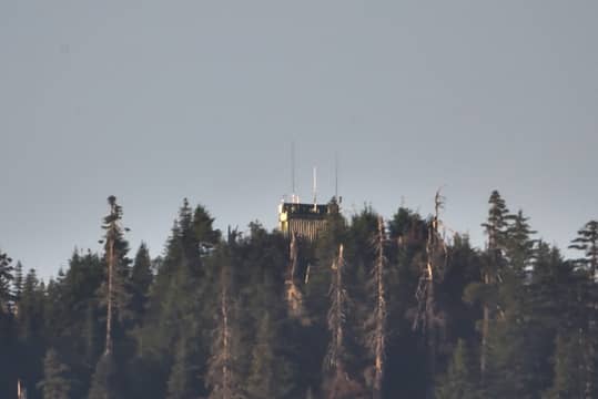 As shot through my telescope from home.
|
| Back to top |
|
|
Joey
verrry senior member

Joined: 05 Jun 2005
Posts: 2799 | TRs | Pics
Location: Redmond |
|
Joey
verrry senior member
|
Sat Mar 17, 2018 11:08 am |
|
|
|
| Back to top |
|
|
|
|


