| Previous :: Next Topic |
| Author |
Message |
Brushbuffalo
Member


Joined: 17 Sep 2015
Posts: 1887 | TRs | Pics
Location: there earlier, here now, somewhere later... Bellingham in between |
On my leisurely quest to visit as many existing and former fire lookout sites as convenient (well, some don't fit the "convenient" category  ) I jogged up to the Carne Mountain site on July 7, 1998, after visiting the Basalt Peak former lookout site earlier in the day. I had been led to believe that the lookout on Carne was not on the summit(7085'), despite what Beckey claimed in CAG: "A short path from the main trail junction leads to the summit lookout". Despite evidence to the contrary in my possession in 1998 (see below), for some now-forgotten reason I thought it would be on "Southwest Carne" (ca. 6700'+). I went up and seeing the flat summit of that point with its excellent Chiwawa valley view, I ran back down satisfied due to my prior (false) conviction that the lookout had been on that location.
I took no photos, probably believing that no one but me would ever care about such trivia as this. ) I jogged up to the Carne Mountain site on July 7, 1998, after visiting the Basalt Peak former lookout site earlier in the day. I had been led to believe that the lookout on Carne was not on the summit(7085'), despite what Beckey claimed in CAG: "A short path from the main trail junction leads to the summit lookout". Despite evidence to the contrary in my possession in 1998 (see below), for some now-forgotten reason I thought it would be on "Southwest Carne" (ca. 6700'+). I went up and seeing the flat summit of that point with its excellent Chiwawa valley view, I ran back down satisfied due to my prior (false) conviction that the lookout had been on that location.
I took no photos, probably believing that no one but me would ever care about such trivia as this.  Fast forward.....
As my lookout explorations continued, I encountered several statements in hiking guides and trip reports that the Carne Mountain lookout had been on "South Carne," Point 6991'. No less a source than Crowder and Tabor's "Routes and Rocks: Hiker's Guide to the North Cascades from Glacier Peak to Lake Chelan" says: "From the junction with the Estes Butte Trail, the Carne Mountain - Leroy Creek Trail traversed north, passes the junction of a trail leading 0.3 miles to a destroyed lookout..." That would be on Point 6991' ! I could have checked their book first in order to avoid a 19 year personal mystery.
Fast forward.....
As my lookout explorations continued, I encountered several statements in hiking guides and trip reports that the Carne Mountain lookout had been on "South Carne," Point 6991'. No less a source than Crowder and Tabor's "Routes and Rocks: Hiker's Guide to the North Cascades from Glacier Peak to Lake Chelan" says: "From the junction with the Estes Butte Trail, the Carne Mountain - Leroy Creek Trail traversed north, passes the junction of a trail leading 0.3 miles to a destroyed lookout..." That would be on Point 6991' ! I could have checked their book first in order to avoid a 19 year personal mystery.  I possessed the guide book 3 decades before my 1998 run, and having worked with Dwight and Rowland, I knew how authoritative their information invariably is. Then I looked at the Holden 15' USGS map (which I have also had all this time, original version from 1944 with minor corrections in 1968 ) and sure enough, it shows no lookout (destroyed in 1955 according to Spring and Fish's book and also in Ray Kresek's book) but the map shows the short branch trail just mentioned....going to the top of Point 6991! C & T's map omits the trail, being published in 1965.
So long story shorter, during a day hike on October 7, after scrapping our plans for the Carne Mountain - Leroy Creek High Route due to weather, I hiked with friends to Carne Basin. The other four hiked to Carne summit and I went up Point 6991' to see for myself if the lookout had been there as reported.
Small mystery solved. It was indeed on "South Carne", Point 6991'. The only evidence visible with a few inches of snow cover were the four anchoring devices (pictured), still in their assumed original four corners. I possessed the guide book 3 decades before my 1998 run, and having worked with Dwight and Rowland, I knew how authoritative their information invariably is. Then I looked at the Holden 15' USGS map (which I have also had all this time, original version from 1944 with minor corrections in 1968 ) and sure enough, it shows no lookout (destroyed in 1955 according to Spring and Fish's book and also in Ray Kresek's book) but the map shows the short branch trail just mentioned....going to the top of Point 6991! C & T's map omits the trail, being published in 1965.
So long story shorter, during a day hike on October 7, after scrapping our plans for the Carne Mountain - Leroy Creek High Route due to weather, I hiked with friends to Carne Basin. The other four hiked to Carne summit and I went up Point 6991' to see for myself if the lookout had been there as reported.
Small mystery solved. It was indeed on "South Carne", Point 6991'. The only evidence visible with a few inches of snow cover were the four anchoring devices (pictured), still in their assumed original four corners.
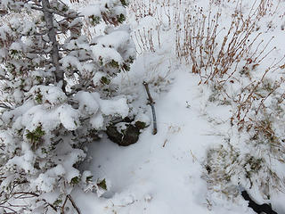 the four anchor devices 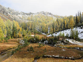 Point 6991, the former lookout site, viewed from Carne Basin. 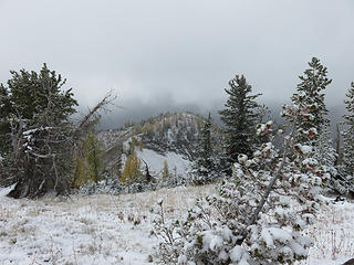 Point 6700+ in middle distance, NOT the site, as seen from Point 6991'.
Passing rocks and trees like they were standing still
Passing rocks and trees like they were standing still
|
| Back to top |
  
|
|
Riverside Laker
Member

Joined: 12 Jan 2004
Posts: 2819 | TRs | Pics
|
Yes, that was the lookout site. Also there is an abandoned trail leading from near there to Estes Butte lookout site, which I followed once. Neato route. It shows up on the level 4 map (100,000:1 scale) in Nat'l Geographic Topo.
|
| Back to top |
|
|
Brushbuffalo
Member
Joined: 17 Sep 2015
Posts: 1887 | TRs | Pics
Location: there earlier, here now, somewhere later... Bellingham in between |
That trail from Carne Basin to Estes Butte is also shown on the USGS 15' map and on Crowder and Tabor's Holden map in their Routes and Rock book.
Dave C. finished his adventurous Entiat Mountains loop just a couple of days before we were up on Carne. He gives some details about that trail.
I visited the Estes Butte site in 1997 using the trail starting from the south. Maybe some day I'll try the whole thing from the north.
Passing rocks and trees like they were standing still
Passing rocks and trees like they were standing still
|
| Back to top |
|
|
cartman
Member

Joined: 20 Feb 2007
Posts: 2800 | TRs | Pics
Location: Fremont |
|
cartman
Member
|
 Mon Oct 09, 2017 3:49 pm |
|
|
In August 2011 I soloed the trail from Carne, around Old Gib, over Estes Butte and to Estes Lookout and down to the road, and it was in excellent condition. Lots of views along the way esp. once past Old Gib.
|
| Back to top |
|
|
Riverside Laker
Member
Joined: 12 Jan 2004
Posts: 2819 | TRs | Pics
|
I did a similar trip some years ago, doing a figure-8 loop. Hiked to Estes Butte, Old Gib, Carne. Then traversed to Pomas Pass which goes quite well (might be a traverse in R&R?). Took the very abandoned trail down to Ice Creek and up to Ice Lakes -- a very lonely route. Then took the Carne High Route to Carne again and dropped down the Rock Cr trail. That last trail had tons of blowdown due to storms that caused lots of damage in the area. But that was 15 years ago, so maybe the trail has improved? Anyway, what a fantastic area.
More is here: wta report
|
| Back to top |
|
|
Brushbuffalo
Member
Joined: 17 Sep 2015
Posts: 1887 | TRs | Pics
Location: there earlier, here now, somewhere later... Bellingham in between |
Your figure 8 route sounds fascinating, but it would be difficult and sad now that the Entiat Valley is so badly burned. 
Passing rocks and trees like they were standing still
Passing rocks and trees like they were standing still
|
| Back to top |
|
|
Riverside Laker
Member
Joined: 12 Jan 2004
Posts: 2819 | TRs | Pics
|
Is it burned that far upstream? Yikes.
|
| Back to top |
|
|
Brushbuffalo
Member
Joined: 17 Sep 2015
Posts: 1887 | TRs | Pics
Location: there earlier, here now, somewhere later... Bellingham in between |
Apparently. Various reports on this forum show and tell of the devastation from the 2015 Wolverine fire, including in a large portion of the upper Entiat.
There are others who might be reading who are much more knowledgable about Entiat conditions than I.
Passing rocks and trees like they were standing still
Passing rocks and trees like they were standing still
|
| Back to top |
|
|
cartman
Member
Joined: 20 Feb 2007
Posts: 2800 | TRs | Pics
Location: Fremont |
|
cartman
Member
|
Mon Oct 09, 2017 7:30 pm |
|
|
Interesting route, RL. That's a lot of ground you covered. When I was there six years ago, looking down the upper Rock Creek Valley was a mass of toppled trees, probably from a major avalanche.
The upper basin on the way to Chilly had the largest concentration of Western anemone I've ever seen.
Think the Wolverine Fire burned the upper Entiat Valley all the way to the ridge connecting Buckskin to Tinpan. But it spared the meadows in upper Ice Creek Valley just west of South Spectacle, which in fall are a riot of color.
|
| Back to top |
|
|
DIYSteve
seeking hygge

Joined: 06 Mar 2007
Posts: 12654 | TRs | Pics
Location: here now |
|
DIYSteve
seeking hygge
|
Mon Oct 09, 2017 8:17 pm |
|
|
|
| Back to top |
|
|
Brushbuffalo
Member
Joined: 17 Sep 2015
Posts: 1887 | TRs | Pics
Location: there earlier, here now, somewhere later... Bellingham in between |
Good idea, Steve....for now. Wouldn't have helped on my initial foray in 1998, which was before internet everything.
Passing rocks and trees like they were standing still
Passing rocks and trees like they were standing still
|
| Back to top |
|
|
Redwic
Unlisted Free Agent

Joined: 23 Feb 2009
Posts: 3292 | TRs | Pics
Location: Going to the Prom(inence) |
|
Redwic
Unlisted Free Agent
|
Tue Oct 10, 2017 6:29 pm |
|
|
60 pounds lighter but not 60 points brighter.
|
| Back to top |
|
|
Pyrites
Member
Joined: 16 Sep 2014
Posts: 1885 | TRs | Pics
Location: South Sound |
|
Pyrites
Member
|
Wed Oct 11, 2017 1:28 am |
|
|
Ive got to disagree with BB, maybe. Sometimes looking around, pondering, a little bushwhacking, its a part of the fun. Too much research removes some of the fun. The game isnt always the same if you know the order of the cards in the deck.
Erics website has a nice description of the lookout site and maps.
Best.
Keep Calm and Carry On?
Heck No.
Stay Excited and Get Outside!
Keep Calm and Carry On?
Heck No.
Stay Excited and Get Outside!
|
| Back to top |
|
|
Brushbuffalo
Member
Joined: 17 Sep 2015
Posts: 1887 | TRs | Pics
Location: there earlier, here now, somewhere later... Bellingham in between |
No doubt, Pyrites.
I indicated the same thoughts in a recent thread initiated by Cartman about the peak near Mt. Watson provisionally named "Elementary." In wandering around the hills half a century ago we usually had little beta to research, certainly not anything like the avalanche of information available today ( the abundance of which has advantages and disadvantages).
It is certainly true that fumbling around in the woods, cliffs, and meadows, trying to find and follow old trails ( if there are any), 'swhacking, etc. is a mix of satisfaction and frustration = exhilaration. My point about Carne is that my conclusion without substantiation was just wrong from my 1998 jaunt but hints were in my possession if I had bothered to check.
Much ado on my part about nothing, but to personally correct my wrong idea of where the Carne lookout used to be was a good excuse to get out again to that great little corner of the Cascades.
[In 2016 I had emailed Eric W. about the Carne lookout site, saying to him that I believed the lookout had been on Point 6700+, and we agreed that confirmation was needed if it was there (no) or on Pt. 6991( yes)....done!]
Passing rocks and trees like they were standing still
Passing rocks and trees like they were standing still
|
| Back to top |
|
|
Pyrites
Member
Joined: 16 Sep 2014
Posts: 1885 | TRs | Pics
Location: South Sound |
|
Pyrites
Member
|
Wed Oct 11, 2017 12:24 pm |
|
|
Collaboration exposes its beautiful face.
Keep Calm and Carry On?
Heck No.
Stay Excited and Get Outside!
Keep Calm and Carry On?
Heck No.
Stay Excited and Get Outside!
|
| Back to top |
|
|
|
|


