| Previous :: Next Topic |
| Author |
Message |
RakCity
Member


Joined: 18 Jun 2018
Posts: 6 | TRs | Pics
|
|
RakCity
Member
|
 Mon Jun 18, 2018 5:43 pm |
|
|
We are looking to head out to this area for 4 days. Not looking to get into anything too hairy. As in, it would be nice if we didn't need crampons. Just wondering if anyone knows of the conditions in the high country along this route.
Also, we considered getting into the Jade Lake, Marmot Lake, Robin Lake, Tuck Lake area. I assume that is probably much more snow in this area, but if I am mistaken, please let me know!!
Thanks so much for any help!
First Post!
|
| Back to top |
  
|
|
Nancyann
Member
Joined: 28 Jul 2013
Posts: 2320 | TRs | Pics
Location: Sultan Basin |
|
Nancyann
Member
|
Mon Jun 18, 2018 8:12 pm |
|
|
How soon are you thinking about doing this trip? When we did that loop in early August two years ago, the snow was still melting out where the trail traverses the cirque below Blue Lake and Johnson Peak. The Blue Lake High Route, if you choose that way, is no doubt still under snow at this time. I dont know about crampons, but I sure would bring an ice axe and Microspikes at the very least. Also, as you head up the North Fork Sauk trail, take a peek at the water level in the North Fork Sauk where you have to cross it, if you are planning on going out Pilot Ridge, so you dont have any surprises at the end of your trip. 
|
| Back to top |
|
|
RichP
Member

Joined: 13 Jul 2006
Posts: 5634 | TRs | Pics
Location: here |
|
RichP
Member
|
Mon Jun 18, 2018 8:47 pm |
|
|
|
| Back to top |
|
|
Nancyann
Member
Joined: 28 Jul 2013
Posts: 2320 | TRs | Pics
Location: Sultan Basin |
|
Nancyann
Member
|
Mon Jun 18, 2018 9:05 pm |
|
|
SHA always writes such great trip reports.  The only thing I would like to add is that we got a lot of snow this year and depending on the aspect of the terrain, there is still a lot of deep snow in some areas. For example, today at 4,100ft, One Acre Lake below Mt. Stickney, there were still vast stretches of snow 5-6 feet deep. The lake was just barely starting to melt out. The only thing I would like to add is that we got a lot of snow this year and depending on the aspect of the terrain, there is still a lot of deep snow in some areas. For example, today at 4,100ft, One Acre Lake below Mt. Stickney, there were still vast stretches of snow 5-6 feet deep. The lake was just barely starting to melt out.
|
| Back to top |
|
|
RakCity
Member
Joined: 18 Jun 2018
Posts: 6 | TRs | Pics
|
|
RakCity
Member
|
Tue Jun 19, 2018 9:06 am |
|
|
Thanks for the info!
Do you know if there are any campsites on Pilot Ridge?
|
| Back to top |
|
|
Nancyann
Member
Joined: 28 Jul 2013
Posts: 2320 | TRs | Pics
Location: Sultan Basin |
|
Nancyann
Member
|
Tue Jun 19, 2018 10:53 am |
|
|
I remember a flat area with a little snow left in the vicinity of the saddle a few miles from the trailhead, where the trail loses about 800 feet and then gains it back again. If you go early in the season, there should be plenty of snow to melt if you need to bivy along the way. When are you thinking about doing your trip?
|
| Back to top |
|
|
RakCity
Member
Joined: 18 Jun 2018
Posts: 6 | TRs | Pics
|
|
RakCity
Member
|
Tue Jun 19, 2018 12:04 pm |
|
|
Thinking about this weekend
|
| Back to top |
|
|
Nancyann
Member
Joined: 28 Jul 2013
Posts: 2320 | TRs | Pics
Location: Sultan Basin |
|
Nancyann
Member
|
Tue Jun 19, 2018 12:31 pm |
|
|
Here is a photo looking towards the White Pass area of Glacier Peak, with Pilot Ridge somewhere off to the left of GP, taken one week ago. Sorry for the crappy resolution, its a cell phone zoom.
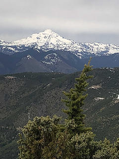 Glacier Peak from Beckler Peak 6/11/18 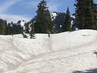 One Acre Lake, Mt. Stickney 6/19/18 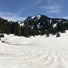 One Acre Lake, Mt. Stickney 6/19/18
|
| Back to top |
|
|
Kim Brown
Member
Joined: 13 Jul 2009
Posts: 6900 | TRs | Pics
|
June is awfully early for White Pass, etc. Hop onto WTA's site and do a search to gauge when trip reports begin appearing for that area year to year (there is nearly 20 years of trip reports there, so it should give a pretty good idea). Search Blue Lakes, Bald Eagle, Pilot Ridge, PCT White Pass, Little Wenatchee Loop - sometimes folks drop over to Blue Lakes when on that loop.
Do the same w/ the other trails you're interested in.
"..living on the east side of the Sierra world be ideal - except for harsher winters and the chance of apocalyptic fires burning the whole area."
Bosterson, NWHiker's marketing expert
"..living on the east side of the Sierra world be ideal - except for harsher winters and the chance of apocalyptic fires burning the whole area."
Bosterson, NWHiker's marketing expert
|
| Back to top |
|
|
RakCity
Member
Joined: 18 Jun 2018
Posts: 6 | TRs | Pics
|
|
RakCity
Member
|
Tue Jun 19, 2018 1:53 pm |
|
|
Thanks for the help. We are fine with travel over snow. Just trying to figure out what to expect.
I've looked through a lot of reports, but this year had relatively more snow and a warmer spring.
|
| Back to top |
|
|
Foist
Sultan of Sweat

Joined: 08 May 2006
Posts: 3974 | TRs | Pics
Location: Back! |
|
Foist
Sultan of Sweat
|
Tue Jun 19, 2018 3:32 pm |
|
|
You will definitely have steep snow fields this weekend. Bring (and know how to use) an ice axe and traction if you go, although you said you're comfortable on snow so presumably I'm preaching to the choir.
Oh and others have said, check out the NF Sauk crossing at the beginning of your hike. There may still be a giant tree lying across that you can walk or crawl over, but you don't want to find out whether that is true only at the END of your trip.
|
| Back to top |
|
|
Nancyann
Member
Joined: 28 Jul 2013
Posts: 2320 | TRs | Pics
Location: Sultan Basin |
|
Nancyann
Member
|
Tue Jun 19, 2018 3:38 pm |
|
|
Kim and Foist have some good suggestions. If you do go, watch out for creek crossings where there is still deep snow, which has been softened by the hot sun. There is a real potential for falling through where the snow is undermined by the creek. Also beware of snow bridges, many of which are ready to collapse now.
Basically, if the conditions were better, a lot of us would be up there.  On the plus side, there will be very few bugs. We didnt see any yesterday.
|
| Back to top |
|
|
RakCity
Member
Joined: 18 Jun 2018
Posts: 6 | TRs | Pics
|
|
RakCity
Member
|
Tue Jun 19, 2018 4:33 pm |
|
|
Perfect. Sounds good. I think that we're going to end up bringing our snowshoes and ice axes.
Thanks for the tips.
|
| Back to top |
|
|
RakCity
Member
Joined: 18 Jun 2018
Posts: 6 | TRs | Pics
|
|
RakCity
Member
|
Fri Jun 29, 2018 12:52 pm |
|
|
We ended up doing Cady Ridge-PCT-Meander Meadow/Little Wenatchee.
Most of the route was snow, pretty much everything above 5k feet. Route finding was a bit tricky cutting across Cady Ridge behind the high points. It shouldn't have been too bad on the PCT, but we were pretty densely socked in up there, so the compass was needed. The snow was pretty stable the whole way though. We were pretty thankful for the cloud cover while on the PCT as this was the steepest part of the journey requiring bootpacking a couple of steep pitches and traversing some side-faces. Overall, snowshoes were pretty helpful and the ice axes were great for a piece of mind.
It will probably be a while before this melts out though.
|
| Back to top |
|
|
chiwakum
not credible

Joined: 29 Jun 2009
Posts: 980 | TRs | Pics
Location: Ballard |
|
chiwakum
not credible
|
Fri Jun 29, 2018 2:55 pm |
|
|
Thanks for following up with a conditions update
|
| Back to top |
|
|
|
|


