| Previous :: Next Topic |
| Author |
Message |
frankm3
Member

Joined: 11 Oct 2003
Posts: 338 | TRs | Pics
Location: Seattle, WA |
|
frankm3
Member
|
 Tue Mar 15, 2005 8:11 am |
|
|
Sunday morning Quark, Zoe, and I headed out to the Mountain Loop outside Granite Falls past Verlot to the Walt Bailey trail. Barring one other car (who we met up with and were overnighting), we were the only car there at 9:30 Sunday morning.
The hike is about 4 miles each way to get to the Cutthroat Lakes, which are at about 4,000' in elevation. The trail is in the Mt. Pilchuck NRCA (Natural Resources Conservation Area), the area is anomolous for the high amount of rain and snowfall, and the predominance of subalpine plants at unusually low elevations.
The trail starts off climbing moderately through the woods for about a mile and a half; and proceeds through a HUGE picturesque meadow which would be fun to explore in it's own right. After passing through the meadow, it's back into the woods a bit; and then across a talus slope and up some more to the high heather meadows and scenery of the Cutthroat Lakes.
The trail was generally snow-free through the first couple miles, what little snow remained was pretty easy traveling. We ate lunch, wandered around a bit, and headed back to the car, making it back by about 5:30.
I really enjoyed this hike immensely; the alpine scenery and the views were pretty amazing for someplace so close to home.
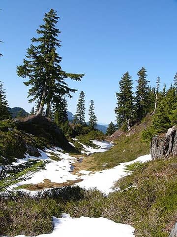 Scenery of Cutthroat Lakes area 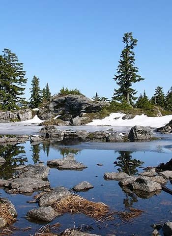 One of the Cutthroat Lakes 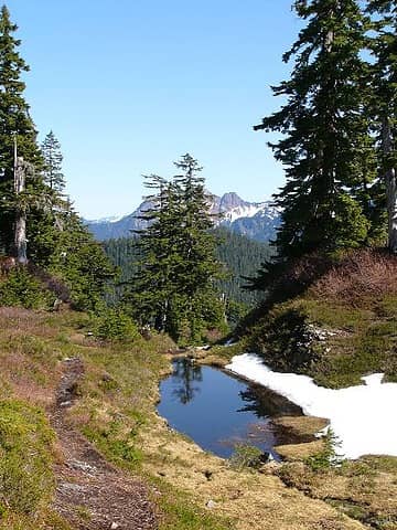 Scenic Tarn 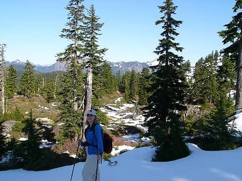 Famous NW Hiker Quark
|
| Back to top |
  
|
|
Quark
Niece of Alvy Moore

Joined: 15 May 2003
Posts: 14152 | TRs | Pics
|
|
Quark
Niece of Alvy Moore
|
Tue Mar 15, 2005 8:53 am |
|
|
It's the best bang for the buck in the scenery department!  The books talk about the amateur trail work and that it takes un-necessary meaders and elevation losses. So what? It wanders through some pretty darn gorgeous meadows. I thought it was very well constructed! Lots of mudholes and such, but that occurs after the fact, and what trail doesn't have mudholes in it?
"...Other than that, the post was more or less accurate."
Bernardo, NW Hikers' Bureau Chief of Reporting
"...Other than that, the post was more or less accurate."
Bernardo, NW Hikers' Bureau Chief of Reporting
|
| Back to top |
|
|
pequod
Freakin armature

Joined: 21 Jan 2005
Posts: 117 | TRs | Pics
|
|
pequod
Freakin armature
|
Tue Mar 15, 2005 5:21 pm |
|
|
Nice pics and report.
The Walt Bailey Trail is one of my all-time favorites..
Сильно как бык, франтовской как трактор
Сильно как бык, франтовской как трактор
|
| Back to top |
|
|
Tsolo
Member
Joined: 16 Dec 2001
Posts: 166 | TRs | Pics
Location: Seattle |
|
Tsolo
Member
|
Tue Mar 15, 2005 7:35 pm |
|
|
It's amazing how little snow there is up there. It looks more like normal July levels.
I did this hike once in the late autumn, and didn't really have a lot of time to explore around, but I remember that there were some interesting rocks in the area (big chunks of quartz), and LOTS of bear scat.
Apparently there's also a trail (maybe only a route) into the area from the east side. Has anyone ever done it that way? What's it like?
|
| Back to top |
|
|
Snowshoe Hare
Defunct lagomorph

Joined: 03 Dec 2004
Posts: 1185 | TRs | Pics
|
| Tsolo wrote: | | Apparently there's also a trail (maybe only a route) into the area from the east side. Has anyone ever done it that way? What's it like? |
The trail you speak of used to be accessable from the Spada Lake side, but the county gated, bermed and ditched the road to the old trailhead since it's now in the lake's watershed. I guess you could hike or ride a bike the few miles to it, though I don't know the legality of doing that since again it is in a watershed area, and I doubt the trail has gotten any maintenance for quite a while. The old trailhead on that side was only a mile or two from the Cutthroat Lks and I think it's for the better that they closed it, since the proximity just made it easier for yahoos to trash the place.
|
| Back to top |
|
|
Tsolo
Member
Joined: 16 Dec 2001
Posts: 166 | TRs | Pics
Location: Seattle |
|
Tsolo
Member
|
Wed Mar 16, 2005 8:52 am |
|
|
Snowshoe --
Thanks for the update. I guess I can cross that route off my to-do list.
I assume that's the same access road that used to let you climb Vesper and Sperry Peaks from the Spada Lake side.
|
| Back to top |
|
|
|
|


