Previous :: Next Topic |
Author |
Message |
Eric Gilbertson Member
Joined: 04 Jul 2018 Posts: 188 | TRs | Pics Location: Seattle |
Silver Star Mountain (8,876ft)
Feb 14, 2021
10 miles skiing, 14 miles snowmobiling
Eric and Johnny
I found myself in the Mazama area for the long weekend avoiding the heavy snows down south to find drier conditions and more stable snow for mountaineering. Saturday I had snowmobiled up to Washington Pass to ski the Birthday Tour and on the way up had noticed a snowmobile parked at the Silver Star pullout. Skin tracks went up into the woods and I suspected they were skiing Silver Star Mountain.
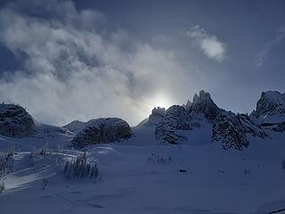
Looking up at the summit from the edge of treeline
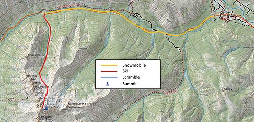
 The route 
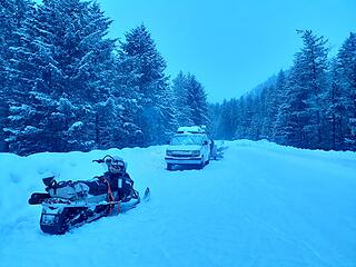
Starting at Early Winters Campground
Silver Star was on my list of Bulgers to climb in the winter. Back in 2017 Katie and I had planned to snowshoe up Silver Star but hadn’t realized the road closure was down at Early Winters campground 7 miles down the road from the start of the route. That was a bit too much to add 14 miles round trip on snowshoes, so we had to change objectives and climb a different peak closer by instead. I later skied Silver Star that April from Silver Star creek, and then climbed it again in September 2018 from Burgundy Col. But I still wanted to come back and get it in winter.
Snow conditions were stable on north faces in the area and with a skin track already laid for us and decent weather forecast it was an easy call to go for Silver Star on Sunday. We got a very casual start, leaving the Early Winters staging area at 8am. I was on one snowmobile, Johnny on another, and Damon and Matt doubled Canadian style on a third one.
Highway 20 was in excellent shape and we made it the seven miles to Silver Star creek in about 15 minutes. We parked the sleds and soon started skinning up into the woods. A few inches of snow had fallen overnight but the old skin track was easy to follow. (Thanks to the skiers who set it!)
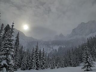
Looking up from the 5,000ft basin 
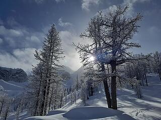
Passing by larches at 6,400ft 
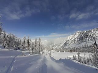
Looking back down the valley
After a few hours we reached a flat area 4,800ft and Damon and Matt needed to turn around. They had a flight to catch out of Seattle that night and it was a long drive back. Johnny and I continued, and soon heard a helicopter overhead. I’d remembered seeing flags at the col near the summit back in April and suspected the heli skiers skied the north face route. It was actually good news that they were skiing it today, since they would be thoroughly testing the snow stability before we got there.
We soon reached a clearing at 5,000ft and saw fresh ski tracks and flagging for a heli pickup zone. At the clearing we headed up to the right through the trees, zig zagging higher until we leveled out around 5,800ft in sparse larch trees. The skies started clearing and we had views of the impressive wine spires above us, with the more rounded Silver Star looming in the distance.
We followed skin tracks to the edge of treeline and noticed they ended at a bench at 6,600ft. I remembered my route from April and went up and skiers left of a big nunatuk-like outcropping. We followed low-angle terrain up left and then met up with some heli-skier tracks. The tracks compacted the snow and it made things a little bit easier to follow those up through the gully.
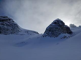
Our route up and left of this rock outcrop 
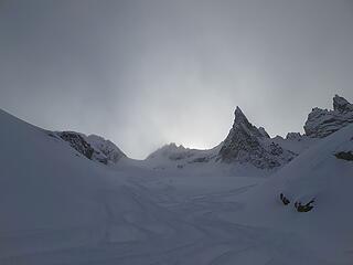
Lots of heli skier tracks above us 
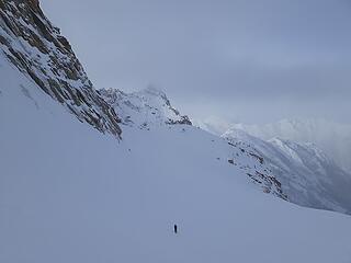
Looking down the north face
As I rounded the top I saw a helicopter had just dropped off a group of nine (!) skiers just below the col, and they were skiing down towards us. Luckily they diverted away to a different run and never got too close. I suspect they saw us from the helicopter and were being careful to avoid skiing into us. They must have been doing many runs, since their tracks spanned the full width of the north face.
We ascended up to a bench below the col as the helicopter dropped them off again a bit below and northwest of us. As we skinned higher the snow got a bit firmer and we eventually decided to just boot the last bit instead of putting on ski crampons. We took turns wallowing through waist-deep snow but eventually carved out a path up to the col by 3:45pm.
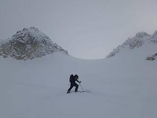
Skiining up to the col
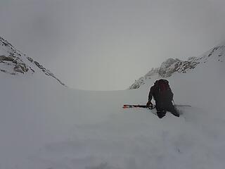
 Booting to the col 
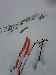
Ditching the skis, looking up at the summit
Unfortunately by then the clearing skies had gone and were replaced with thick clouds. It was surprisingly warm, though. On Saturday it had been hovering around 0F above treeline, but now my thermometer read 25F. It must have been an inversion.
At the col we ditched skis and switched to crampons. Johnny peeked over a south gully that looked scoured down to rocks. I led the way up from the col, kicking steps in shallow snow at times, then scrambling on rocks higher up.
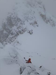
Starting the scramble The offwidth/chimney scramble 
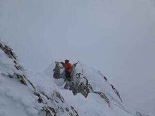
Johnny on the summit
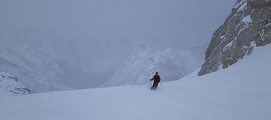
About 20ft below the summit I ditched my ice axe and wriggled up the final chimney. My crampons were just long enough to get a delicate foot jam in sideways, then I mantled up to the top of the chimney. I then scrambled over and could just barely reach up to tap the highpoint after clearing the rime ice from it.
We took turns snapping pictures on the top. Unfortunately visibility was pretty low, but we got fleeting glimpses over to the wine spires and the col to the west. We soon downclimbed back to the skis and started our amazing descent. Johnny led the way as we carved turns down steeply from the col then more gradually below. The heli skiers tracks had hardened and made things a bit more difficult, but we were still able to find some powder to ski.
Skiing down 
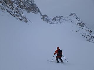
Skiing down Dropping down below treeline
We skied down around the nunatuk and then cut right at the trees and skied a fun line skiers right to the pickup zone at 5,000ft. From there the terrain leveled out and we switched to climb mode to scoot back out our tracks. Back at 4,800ft it got steep enough to ski again, and we had a fun descent back to the sleds by dark.
Both snowmobiles started no problem, and we quickly rode back to the staging area by 6:15pm. Amazingly it had taken just two hours to get from the summit back to the cars, and only around 10 hours round trip for the day.
Snow started again that evening and I spent another night camped out at the staging area.
Link to more pictures
|
Back to top |
|
|
puzzlr Mid Fork Rocks
Joined: 13 Feb 2007 Posts: 7220 | TRs | Pics Location: Stuck in the middle |
|
puzzlr
Mid Fork Rocks
|
Wed Feb 17, 2021 3:23 pm
|
|
|
Wow! Nothing more to add
|
Back to top |
|
|
Fletcher Member
Joined: 29 Jul 2009 Posts: 1870 | TRs | Pics Location: kirkland |
|
Fletcher
Member
|
Wed Feb 17, 2021 5:25 pm
|
|
|
Awesome Eric! When’s Bonanza?
|
Back to top |
|
|
Eric Gilbertson Member
Joined: 04 Jul 2018 Posts: 188 | TRs | Pics Location: Seattle |
Quote: | Awesome Eric! When’s Bonanza? |
Thanks! No plans yet but Bonanza would be a fun one to ski.
|
Back to top |
|
|
forest gnome Forest nut...
Joined: 24 Apr 2003 Posts: 3520 | TRs | Pics Location: north cascades!! |
What did u fin In the pits you dug out ?
|
Back to top |
|
|
Eric Gilbertson Member
Joined: 04 Jul 2018 Posts: 188 | TRs | Pics Location: Seattle |
Quote: | What did u fin In the pits you dug out ? |
On north and northeast aspects above 8,000ft we found a thin firm windslab layer about 4" below the surface. Steep northwest aspects had released small loose dry slides naturally.
|
Back to top |
|
|
timberghost Member
Joined: 06 Dec 2011 Posts: 1333 | TRs | Pics
|
|
Back to top |
|
|
Blowdown Sawin' Logs ...
Joined: 24 Aug 2011 Posts: 376 | TRs | Pics Location: On the Summit |
|
Blowdown
Sawin' Logs ...
|
Thu Mar 11, 2021 8:29 am
|
|
|
Epic! Inspiring! And Impressive!
|
Back to top |
|
|
|
You cannot post new topics in this forum You cannot reply to topics in this forum You cannot edit your posts in this forum You cannot delete your posts in this forum You cannot vote in polls in this forum
|
Disclosure: As an Amazon Associate NWHikers.net earns from qualifying purchases when you use our link(s).
|