| Previous :: Next Topic |
| Author |
Message |
Frank
Member


Joined: 10 Jul 2004
Posts: 318 | TRs | Pics
Location: Snohomish |
|
Frank
Member
|
 Tue Mar 07, 2017 7:10 am |
|
|
Group wants forest road near Darrington reopened for day hikes
Kari BrayTue Mar 7th, 2017 1:30amNews
DARRINGTON A group of volunteers wants to reopen a forest road this summer that would connect people to multiple day hikes.
The trails lead to meadows, huckleberry fields, expansive views and the site where a fire lookout once stood.
About 5 miles of the 7-mile Circle Creek Road Forest Service Road No. 2703 need to be cleared and repaired in places so people can drive up to the trailhead for Circle Peak. The trail also splits off toward Crystal Lake. The trek to the peak, where the lookout once stood, is a steep two miles one way. From Circle Peak, there is a rough path to Indigo Lake.
Hiking opportunities are abundant around Darrington, but many of the routes are too long or challenging for older adults or families with young children. Opening Circle Creek Road would create more options for enjoying the striking scenery of the North Cascades Range, according to volunteers with Friends for Public Use and Darrington Area Resource Advocates.
We have very few high alpine day hikes, said Martha Rasmussen, who founded Friends for Public Use in 2012 in hopes of protecting Circle Creek and other forest roads from being decommissioned. I did hike Circle Creek. Its an all-day hike. Its a short hike but its steep, and its worth it.
Circle Creek Road was built decades ago for timber removal. The hiking trails there became especially popular among locals. The road has been closed past its first 1.7 miles for about five years, said Peter Forbes, Darrington District Ranger with the U.S. Forest Service.
In 2012, the Forest Service finished an analysis of its roads in the Suiattle River Recreation Area. With dwindling budgets for maintenance, officials were looking for routes that could be decommissioned. Circle Creek Road was one of them.
Advocates in Darrington sought to save the road. The Sauk-Suiattle Indian Tribe also expressed interest in maintaining access to Circle Peak. In a letter, tribal chairwoman Norma Joseph wrote of huckleberry fields and groves of yellow cedar used for ceremonies and basketry.
Through the nonprofit River Resource Trust, run by some of the same volunteers involved in Friends for Public Use and the resource advocates, donations are being collected to pay for road repairs. The goal is to raise about $25,000 to start, then collect donations for annual upkeep.
Several thousand dollars would go toward hiring a geotechnical engineer. The trickiest part of the repairs is a short stretch damaged by flooding. An engineer needs to approve a fix that meets Forest Service standards.
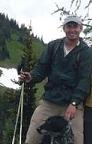
Other tasks include clearing debris and brush, said Frank Urbanski of Stanwood. He retired from the Forest Service after more than 30 years and now volunteers with the resource advocates.
Urbanski, Rasmussen and fellow volunteer Walt Dortch want to make Circle Creek Road an example of how to save public areas put in jeopardy by strapped budgets. Adopting forest roads could become a trend for protecting access to Washingtons wildlands, they said.
We would hope that this would be a showcase project and that once this is done and successful, its something we can do in other places, Urbanski said.
There has been a push to promote outdoor recreation and tourism around Darrington to strengthen the economy. Adding short hikes and places where families can take a scenic drive would help, Dortch said.
The Circle Peak trails are at the top of the list in terms of spectacular views along with the meadows and the huckleberry fields, he said. Its a lot of wonderful things packed into a day hike.
The goal is to start repairs once the snow melts and finish this summer. The timeline depends on weather. Every mountain has a different winter, Rasmussen said.
Forbes thinks a summer reopening of the road is possible as long as the engineering gets done. The rest of the work isnt expected to be as complex.
Volunteers also help monitor and maintain other forest roads. It didnt take long for people to step up when they heard some could be decommissioned, Rasmussen said. The way she figures it, they had two options.
You can complain, she said. Or you can find a solution.
To donate to the Circle Creek Road project, go to riverresourcetrust.org.
Kari Bray: 425-339-3439; kbray@heraldnet.com.
|
| Back to top |
  
|
|
lookout bob
WTA proponent.....

Joined: 12 Apr 2005
Posts: 3046 | TRs | Pics
Location: wta work while in between lookouts |
|
lookout bob
WTA proponent.....
|
Sat Mar 11, 2017 7:42 pm |
|
|
"Altitude is its own reward"
John Jerome ( from "On Mountains")
|
| Back to top |
|
|
Kim Brown
Member
Joined: 13 Jul 2009
Posts: 6900 | TRs | Pics
|
Yes, it works.
"..living on the east side of the Sierra world be ideal - except for harsher winters and the chance of apocalyptic fires burning the whole area."
Bosterson, NWHiker's marketing expert
"..living on the east side of the Sierra world be ideal - except for harsher winters and the chance of apocalyptic fires burning the whole area."
Bosterson, NWHiker's marketing expert
|
| Back to top |
|
|
Martha
FFPU Coordinator

Joined: 05 Apr 2017
Posts: 9 | TRs | Pics
Location: Darrington |
|
Martha
FFPU Coordinator
|
Fri Apr 07, 2017 9:29 am |
|
|
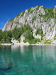
The Circle Creek Road has sat unmaintained for many years and yet remains mostly in good shape because it is a very well built road. There is one area of damage that needs a repair which is what the funds are being raised for. Encroaching brush on this road or any other forest roads is simply ongoing work. Getting this forest road reopened or keeping forest roads open will need to involve public support and public stewardship. Here is one of my favorite views from Circle Peak. Put your hiking boots here!
|
| Back to top |
|
|
JimK
Member

Joined: 07 Feb 2002
Posts: 5606 | TRs | Pics
Location: Ballard |
|
JimK
Member
|
Fri Apr 07, 2017 10:52 am |
|
|
For a relatively low peak it has great views.
|
| Back to top |
|
|
Martha
FFPU Coordinator
Joined: 05 Apr 2017
Posts: 9 | TRs | Pics
Location: Darrington |
|
Martha
FFPU Coordinator
|
Fri Apr 07, 2017 10:57 am |
|
|
What time of year did you take these pics?
|
| Back to top |
|
|
JimK
Member
Joined: 07 Feb 2002
Posts: 5606 | TRs | Pics
Location: Ballard |
|
JimK
Member
|
Fri Apr 07, 2017 11:48 am |
|
|
|
| Back to top |
|
|
Joey
verrry senior member

Joined: 05 Jun 2005
Posts: 2799 | TRs | Pics
Location: Redmond |
|
Joey
verrry senior member
|
Sun Apr 09, 2017 2:49 pm |
|
|
|
| Back to top |
|
|
yew
non-technical
Joined: 12 Dec 2005
Posts: 1173 | TRs | Pics
Location: Bellingham |
|
yew
non-technical
|
Fri Jul 30, 2021 9:02 am |
|
|
Circle Creek Road is open and drivable. It is not shown on the Mt Baker-Snoqualmie National Forest's Roads and Trails webpage
"I aint jokin woman, I got to ramble...We gonna go walkin through the park every day." - Led Zeppelin
 RichP RichP
"I aint jokin woman, I got to ramble...We gonna go walkin through the park every day." - Led Zeppelin
RichP
|
| Back to top |
|
|
Kim Brown
Member
Joined: 13 Jul 2009
Posts: 6900 | TRs | Pics
|
yew, I see it on their website as open and driveable to the trail head.
Opened and maintained by Friends for Public Use.
The trail will be worked on this fall; new puncheon, etc.
Hike it, people. FFPU worked hard at getting that road opened, and we need to use it. It would be a good entry to Meadow Mtn IF the Pain in the Ass Pass between Crystal & Meadow Lakes were logged out, but good God, it's awful now.
"..living on the east side of the Sierra world be ideal - except for harsher winters and the chance of apocalyptic fires burning the whole area."
Bosterson, NWHiker's marketing expert
Slim, RichP
"..living on the east side of the Sierra world be ideal - except for harsher winters and the chance of apocalyptic fires burning the whole area."
Bosterson, NWHiker's marketing expert
Slim, RichP
|
| Back to top |
|
|
camut
Member
Joined: 17 Aug 2006
Posts: 329 | TRs | Pics
Location: stanwood |
|
camut
Member
|
Fri Jul 30, 2021 12:06 pm |
|
|
I was up there last week and was pleasantly surprised to find the road and trail in much better shape than I expected, and in better shape than it was the last time I was here. I had even put my chainsaw in the car, not knowing what we might run into, but there were no problems. This is one fine hike from start to finish!
Thank you FFPU!!
|
| Back to top |
|
|
slabbyd
Member
Joined: 21 Jun 2005
Posts: 294 | TRs | Pics
|
|
slabbyd
Member
|
Fri Jul 30, 2021 4:21 pm |
|
|
The road is in good shape and extremely one lane for a great bit of its 10+ mile long length. If the cat gets out of the bag on this one expect all kinds of driving and parking snafus. Was very glad not to encounter any oncoming traffic on my visit there.
|
| Back to top |
|
|
rossb
Member

Joined: 23 Sep 2002
Posts: 1679 | TRs | Pics
|
|
rossb
Member
|
Sat Aug 21, 2021 4:19 pm |
|
|
I assume folks get to the trailhead via the Suiattle (instead of up and over, via Rat Trap Pass). The description of the closure of the other road (27) was vague enough to make me want to double check.
|
| Back to top |
|
|
Tom
Admin
Joined: 15 Dec 2001
Posts: 17857 | TRs | Pics
|
|
Tom
Admin
|
Sat Aug 21, 2021 4:49 pm |
|
|
I'm pretty sure it's still washed out beyond Rat Trap pass. I wouldn't go over the pass. I drove down a bit a few weeks ago from the pass just to see and while it didn't wash out I turned around at the first spot I could as I didn't want to get stuck having to back up if it washed out in a precarious spot.
|
| Back to top |
|
|
rossb
Member
Joined: 23 Sep 2002
Posts: 1679 | TRs | Pics
|
|
rossb
Member
|
Sat Aug 21, 2021 4:53 pm |
|
|
Thanks. Yeah, they write that the road is washed out, but they don't say where (other than a mileage number, which means nothing to me). I guess it is washed out close to the pass (between the pass and the turnoff to Circle Creek Road) which means the only way to access Circle Creek Road is via the Suiattle.
|
| Back to top |
|
|
|
|


 addendum: I tried to go to Riversourcetrust.org to donate but the link doesn't work.


