| Previous :: Next Topic |
| Author |
Message |
Blowdown
Sawin' Logs ...


Joined: 24 Aug 2011
Posts: 376 | TRs | Pics
Location: On the Summit |
|
Blowdown
Sawin' Logs ...
|
 Thu Oct 14, 2021 7:22 pm |
|
|
Does anyone remember the giant old wooden map, at the trailhead at Asahel Curtis (I think), back about 50 years ago?
Back in Boy Scouts in the late 60s, when I-90 was still US 10, I remember that trailhead map as being real big, something like 8 feet high and 15 feet wide. It was a freestanding kiosk-type structure, with a flat-style map with the trails, streams, and lakes carved out of the wood using a router, with the lakes and streams painted blue. It was the Island Lake area, maybe?
Anyone remember this big wooden map? Anyone have a photo of it? Any idea who made it? Or where it ended up?
 zimmertr zimmertr
zimmertr |
| Back to top |
  
|
|
Schroder
Member

Joined: 26 Oct 2007
Posts: 6723 | TRs | Pics
Location: on the beach |
|
Schroder
Member
|
Sun Oct 17, 2021 11:14 am |
|
|
I remember it but never took a photo of it
|
| Back to top |
|
|
JimK
Member

Joined: 07 Feb 2002
Posts: 5606 | TRs | Pics
Location: Ballard |
|
JimK
Member
|
Sun Oct 17, 2021 12:55 pm |
|
|
I discussed this with a friend this summer. I recalled it from the current trailhead. He recalled it from the earlier pre I-90 trailhead. It was there until maybe 25 years ago. Map in the middle with destinations and distance on the side. I did take a photo of it way back when. Could not find it after our discussion this summer. I will look again. Someone must have a photo of slide of it.
|
| Back to top |
|
|
JimK
Member
Joined: 07 Feb 2002
Posts: 5606 | TRs | Pics
Location: Ballard |
|
JimK
Member
|
Wed Oct 27, 2021 3:19 pm |
|
|
I found this old copy. The full sign at the current Pratt Trailhead had destinations and mileage carved into wood on the side. This is just the map itself.
|
| Back to top |
|
|
Blowdown
Sawin' Logs ...
Joined: 24 Aug 2011
Posts: 376 | TRs | Pics
Location: On the Summit |
|
Blowdown
Sawin' Logs ...
|
Thu Oct 28, 2021 7:12 am |
|
|
JimK wrote: | Quote: | | I found this old copy. |
OMG, Jim, this is AWESOME! Thank you VERY much for finding your old photo.
Funny how I rembered it as being a lot bigger.
I wonder what ever became of it? Probably just got worn out and tossed.
|
| Back to top |
|
|
puzzlr
Mid Fork Rocks

Joined: 13 Feb 2007
Posts: 7220 | TRs | Pics
Location: Stuck in the middle |
|
puzzlr
Mid Fork Rocks
|
Thu Oct 28, 2021 12:48 pm |
|
|
JimK, It's cool to see that old sign. Both connector trails to the Pratt River trail are there -- from Pratt Lake and from Thompson Lake. But there's no Mason Lake trail. Do you have any idea what year you took that?
It looks like it's from the same era as this 1967 sign that was at Camp Brown in the Middle Fork Snoqualmie. Note that there were roads all the way to Hardscrabble then, as well as up the Taylor River and Quartz Creek valleys. The Red Mountain trail was still on the map then.
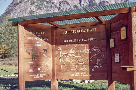 Camp Brown 1967, photo by Eckart Schmidt
|
| Back to top |
|
|
JimK
Member
Joined: 07 Feb 2002
Posts: 5606 | TRs | Pics
Location: Ballard |
|
JimK
Member
|
Thu Oct 28, 2021 2:01 pm |
|
|
puzzlr, thanks for that photo. I had never seen it before.
I took my photo in 7-82 at the current Pratt Lake Trailhead. My sources say it used to be at the old Pratt Trailhead near where the current Denny Creek Road crossed old Highway 10. Look closely and you can see it on the map. Best I can figure the map was there from the mid 1960s. Similar to the 1967 you reference for the MF Map.
Here is a copy of the Pratt Lake hike in the original 100 Hikes in Western Washington. First printing in 1966 and my fifth printing was from 1968. The map shows two trails meeting at the switchback left on the current trail. That junction was very obvious in 1982.
|
| Back to top |
|
|
Kim Brown
Member

Joined: 13 Jul 2009
Posts: 6900 | TRs | Pics
|
That junction is obvious even now! At least it was 2 years ago. I followed the old trail a ways, but was solo and didnt pursue it long. I did not know know where it went; I didnt realize the trail head to Pratt was in a different location. Id like to check out that old trail again!
"..living on the east side of the Sierra world be ideal - except for harsher winters and the chance of apocalyptic fires burning the whole area."
Bosterson, NWHiker's marketing expert
"..living on the east side of the Sierra world be ideal - except for harsher winters and the chance of apocalyptic fires burning the whole area."
Bosterson, NWHiker's marketing expert
|
| Back to top |
|
|
Riverside Laker
Member

Joined: 12 Jan 2004
Posts: 2819 | TRs | Pics
|
| puzzlr wrote: | | Note that there were roads all the way to Hardscrabble then |
A few days ago we went up that Hardscrabble road en route to Big Snow. It gets really steep, seemingly too steep for log trucks. In the boulder field closer to the lake were several cables -- I assume logging cables. Was that for logging, or was there a mining operation up there? We saw several stumps past the boulder field.
|
| Back to top |
|
|
Bramble_Scramble
Member
Joined: 28 Dec 2012
Posts: 312 | TRs | Pics
|
| Riverside Laker wrote: | | puzzlr wrote: | | Note that there were roads all the way to Hardscrabble then |
A few days ago we went up that Hardscrabble road en route to Big Snow. It gets really steep, seemingly too steep for log trucks. In the boulder field closer to the lake were several cables -- I assume logging cables. Was that for logging, or was there a mining operation up there? We saw several stumps past the boulder field. |
When I saw those cables I assumed it was for logging and was very impressed at the effort to get the trees down. I do remember reading a report mentioning a mine or two above upper Hardscrabble Lake. There's also a US mineral marker above the lake but that could be related to the mines down in the Mid Fk Valley(Katie Belle/Pedro/Three Clippers). I still think those cables were for logging though.
Did you come across the logging crane to the left when the Hardscrabble trail meets the old road?
|
| Back to top |
|
|
Riverside Laker
Member
Joined: 12 Jan 2004
Posts: 2819 | TRs | Pics
|
No! Shucks, it'd be fun to see the logging crane.
|
| Back to top |
|
|
Brucester
Member
Joined: 02 Jun 2013
Posts: 1102 | TRs | Pics
Location: Greenwood |
Riverside Laker
Riverside Laker |
| Back to top |
|
|
lopper
off-route

Joined: 22 Jan 2002
Posts: 845 | TRs | Pics
|
|
lopper
off-route
|
Wed Aug 09, 2023 8:46 pm |
|
|
Behold the mining claims
RichP
RichP |
| Back to top |
|
|
|
|


