| Previous :: Next Topic |
| Author |
Message |
Tom
Admin

Joined: 15 Dec 2001
Posts: 17856 | TRs | Pics
|
|
Tom
Admin
|
 Tue Oct 31, 2023 8:46 pm |
|
|
As far as the peakvisor app, I downloaded it thinking it might be better, but I actually prefer desktop. Maybe the ios version of the app is better. On the android app they hide photos without embedded location as well as photos wider than a certain aspect ratio, so I was pulling my hair out trying to find my panos until I realized they hid them by sorting them all to the bottom, and when you try to pull them up they say they are not supported. In any case it was harder to use the app to generate photos with labels because you are using touch screen to zoom and align labels as opposed to the precision of a mouse on desktop, not to mention a much smaller screen. I think the app is really only useful if you want to work with photos directly off your phone, or identify peaks in real time, but for the latter you have to pony up for a premium version of the app for it to work without internet connection.
BTW, if you want to remove the peak profile overlay you can easily do that, just select "peak lablels" for the overlay mode after you have aligned the labels.
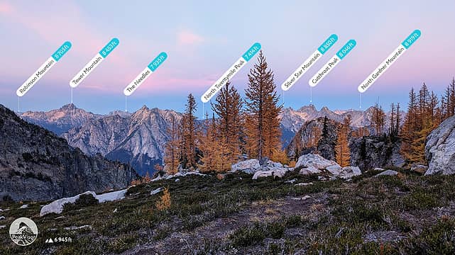 One of the few photos I actually got to work with peakvisor. For the most part I found the photo labeling feature to be a gimmck. It's far more useful to enter location into peakvisor and manually compare the 3D generated profile to photos, zooming in to areas of particular interest to see more labels, rather than upload photos, line things up and be at the mercy of the labels it decides to display which as you can see in this example are very hit or miss. It prioritized distant peaks you can't really see over some of the more prominent peaks in the foreground.
|
| Back to top |
  
|
|
|
|
You cannot post new topics in this forum
You cannot reply to topics in this forum
You cannot edit your posts in this forum
You cannot delete your posts in this forum
You cannot vote in polls in this forum
|
Disclosure: As an Amazon Associate NWHikers.net earns from qualifying purchases when you use our link(s). |


