| Previous :: Next Topic |
| Author |
Message |
puzzlr
Mid Fork Rocks


Joined: 13 Feb 2007
Posts: 7220 | TRs | Pics
Location: Stuck in the middle |
|
puzzlr
Mid Fork Rocks
|
 Thu Sep 28, 2023 8:35 pm |
|
|
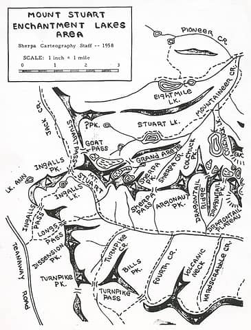
I came across these two maps credited to "Sherpa Carteography Staff". Carteography probably should be Cartography, but it's on the map with an "e". I don't see anything searching for this group. The maps are quite early -- from 1958. Does anyone know about this group? I have a feeling the "Sherpa" might have something to do with the Praters given that they made the Sherpa snowshoes and frequented the Teanaway area.
"Turnpike Peak" on this map is now Teanaway Peak. Dissension Peak just north of it is not a named peak now, although John Morrow has that as a provisional peak on Peakbagger.com with the description "CAG, likely first ascent bill and Gene Prater and company." I couldn't find this in the CAG, but there's got to be a good story there.
 Stuart, Teanaway, Enchantments 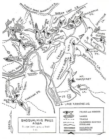 Snoqualmie Pass
Mid Fork Rocks flickr
 mossbackmax, Cyclopath, Schroder, Bramble_Scramble, Now I Fly, Lightning_bug, JimK, dave allyn mossbackmax, Cyclopath, Schroder, Bramble_Scramble, Now I Fly, Lightning_bug, JimK, dave allyn
Mid Fork Rocks flickr
mossbackmax, Cyclopath, Schroder, Bramble_Scramble, Now I Fly, Lightning_bug, JimK, dave allyn
|
| Back to top |
  
|
|
Schroder
Member

Joined: 26 Oct 2007
Posts: 6722 | TRs | Pics
Location: on the beach |
|
Schroder
Member
|
Sun Oct 08, 2023 11:34 am |
|
|
Yes, the Sherpas were a climbing club in Ellensburg led by Gene Prater.
I got my start climbing with a member of this group and climbed with Prater a couple of times.
|
| Back to top |
|
|
Schroder
Member
Joined: 26 Oct 2007
Posts: 6722 | TRs | Pics
Location: on the beach |
|
Schroder
Member
|
Tue Oct 10, 2023 9:25 am |
|
|
| puzzlr wrote: | | Some of the "climbing routes" on this map are a little surprising. Hibox from the north, The Tooth from Denny Creek, Commonwealth Creek directly up to Kendall Peak |
Access to the Tooth was easier up Denny Creek before they built Alpental in 1969 - more elevation gain but less brush. Before the snow was gone, the quicker way into Commonwealth was to start up the shoulder of Guye Peak from the rope tow across from the Washington Alpine Club lodge. All cabins and snow fences in the way now.
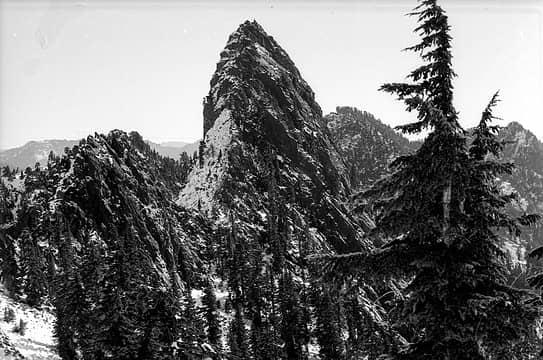 The Tooth 10 Oct 1969 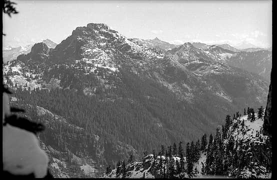 Mt Snoqualmie 10 Oct 1969 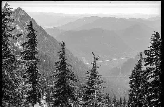 Looking down Denny Creek 10 Oct 1969
Now I Fly  mossbackmax mossbackmax
Now I Fly mossbackmax |
| Back to top |
|
|
Jason Hummel
Member

Joined: 31 Aug 2006
Posts: 1209 | TRs | Pics
Location: Tacoma Washington |
The sherpas and cascadian club was tightly knit. In 1957 the sherpa club made ascents on Stuart, such as the Ice Cliff. They also made an ascent of what they called the South Kennedy Glacier, today's Scimitar Glacier (named for it's shape from the air looking like a Scimitar, or sword). They have some annuals with details on their climbs. They are very hard to find. See here for fascinating info on some of the Sherpa Club that was part of the Cascadian Club (started by C. E. Rusk...see tales of a western mountaineer). www.cascadians.org/resources/Documents/Annuals/Cascadians%20Centennial%20Scrapbook%201920-2020.pdf
|
| Back to top |
|
|
Pyrites
Member
Joined: 16 Sep 2014
Posts: 1884 | TRs | Pics
Location: South Sound |
|
Pyrites
Member
|
Mon Nov 06, 2023 7:49 pm |
|
|
Am I correct in looking at the map that before Alpental there wasnt even a gravel road up that side valley?
Keep Calm and Carry On?
Heck No.
Stay Excited and Get Outside!
Keep Calm and Carry On?
Heck No.
Stay Excited and Get Outside!
|
| Back to top |
|
|
Randito
Snarky Member

Joined: 27 Jul 2008
Posts: 9513 | TRs | Pics
Location: Bellevue at the moment. |
|
Randito
Snarky Member
|
Mon Nov 06, 2023 9:10 pm |
|
|
| Pyrites wrote: | | Am I correct in looking at the map that before Alpental there wasnt even a gravel road up that side valley? |
Pre-Alpental there was no road or it ended at about the Washington Alpine Club Cabin / Sahale Ski Club -- the Snow Lake trail trailhead was the same as the Commonwealth Creek / Cascade Crest trail. It was about six miles to the log cabin on Snow Lake.
|
| Back to top |
|
|
|
|


