Forum Index > Trip Reports > Mt St Helens Survey, Off WA Top 100 List, Oct 20, 2023
 Reply to topic
Previous :: Next Topic
Author Message
Eric Gilbertson
Member
Member


Joined: 04 Jul 2018
Posts: 188 | TRs | Pics
Location: Seattle
Eric Gilbertson
Member
PostMon Oct 23, 2023 9:55 pm 
Mt St Helens Survey Oct 17 and Oct 20, 2023 Eric Gilbertson Summary of Results: Elevation 8,321.1ft +/-0.2ft. Summit is losing elevation at rate of 4 inches/year. Removed from WA Top 100 List Link to up-to-date WA Top 100 list: https://docs.google.com/spreadsheets/d/1gYaBTa32bLfXiQFrcpTJ58KjO1HIAEEMBDrttHFxUOg/edit#gid=0 Mt St Helens is one of the five volcanoes in Washington, and used to be the fifth tallest peak in the state at 9,677ft. On May 18, 1980 it erupted, reducing its elevation to 8,365ft. Since then it has been gradually losing elevation as the loose summit rocks and ash have eroded away. Based on the most recent Lidar surveys it was tied for number 100 on the Washington Top 100 Peaks list, the list of the 100 tallest peaks in Washington.
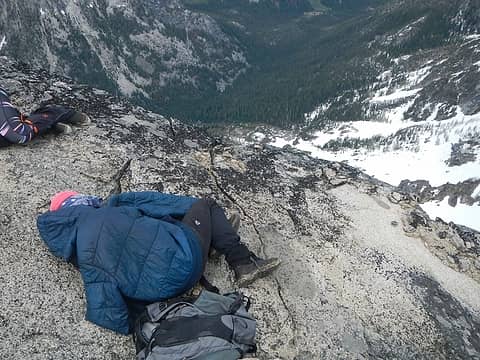
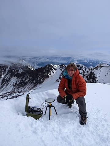
On the summit on the Oct 17 survey attempt (too snowy, so only upper bound measurement)
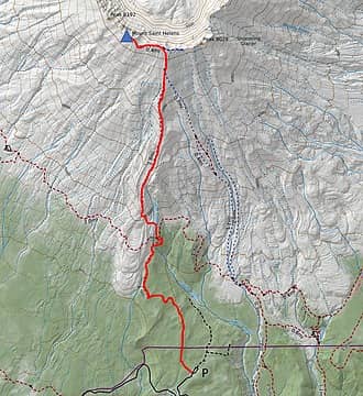
The route
The route
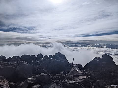
Hiking up above the clouds Tuesday morning
I’m working to conduct very precise ground surveys across Washington to determine the most accurate list of the WA Top 100 peaks. Given that Mt St Helens was so close to the edge of inclusion on the list, I decided to conduct a ground survey to determine a more precise summit elevation. Lidar has stated vertical accuracy of 4 inches with data points taken every 3-6ft horizontal spacing. But in practice the errors can be a bit higher than this. I researched the elevation from past quads and from recent Lidar surveys and found an interesting trend. Between the 1982 quad survey and the 1989 quad survey the elevation dropped from 8,365ft to 8,333ft. This was likely a result of a large chunk of the unstable crater rim sliding off on the steep north face. Other Lidar surveys were conducted in 2002, 2009, 2017, and 2018. In each survey the elevation decreased. I suspect this was also a result of the erosion of the loose volcanic rock and ash that makes up the summit location. The ash can get blown away by wind and rocks can slide off the north face. I wasn’t aware of any physical ground surveys with a differential GPS for the summit of Mt St Helens, though. A differential GPS can get vertical accuracy less than an inch. I’m borrowing a differential GPS unit from Seattle University and have been using it to survey peaks all around Washington. The best way to get the most accurate elevation measurement of St Helens would be to bring that unit to the summit. October is a tricky month to survey, though, because it’s started snowing on the high peaks now. Seasonal snow is not considered in a peak’s elevation. I’d need to measure the actual rock of the summit to get an accurate result. So I needed to make it to the summit when it was snow free, or at least when I could clear the snow off the summit to do a survey. I’d also need to go when the weather was as clear as possible, since my surveyor friends tell me unstable weather can lead to higher measurement errors. So surveying in a rain or snow storm was not a great idea.
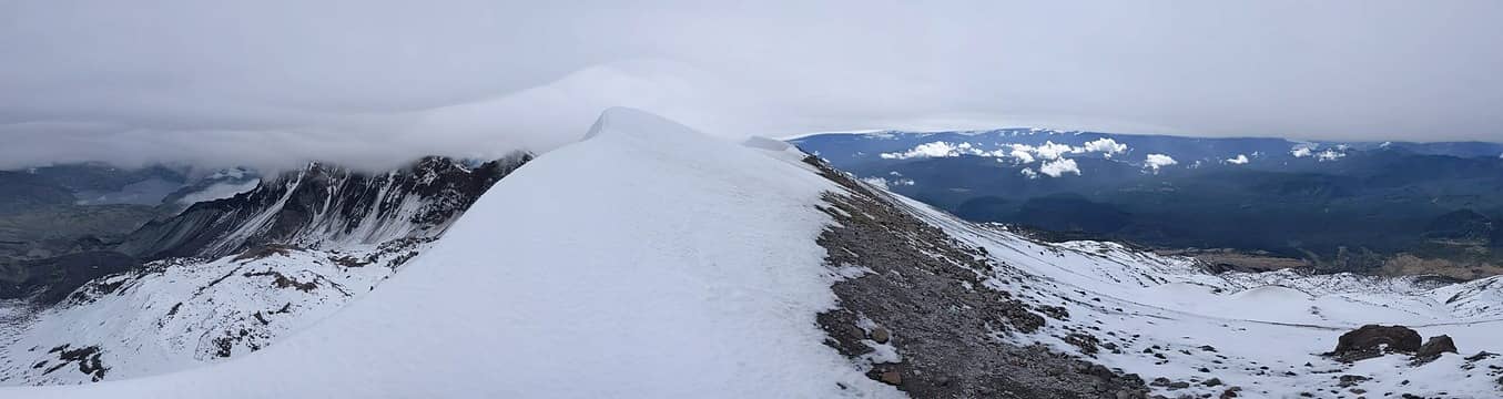
Summit snow conditions Oct 17
I’ve previously climbed St Helens six times, but they were all in winter or early spring when there was a massive cornice on the summit. I think the snow usually melts off the summit by July. So the surveying window is July – October. Luckily I’d just seen a report on peakbagger.com of a team that summitted on October 8. In their summit picture the top was exposed to dirt, which was good news. I knew it hadn’t snowed since that picture, so the surveying window was still open. Another difficulty with surveying in October is there is a quota for permits to climb, capped at 100 people per day. These permits can be purchased online for $21 per person, but weekend days usually fill up, especially if the weather looks good. I was lucky enough to find a few spots open up on the Oct 14-15 weekend. I quickly bought permits for Friday, Saturday, and Sunday just in case one day was good enough weather. In theory if I drove straight from work Friday afternoon I could make it up to the summit and back down before midnight when the permit expired. However, the forecast deteriorated and it was supposed to be rainy and snowy starting Friday eve through the weekend. So I switched objectives last minute and instead surveyed some peaks in the Pasayten where it was drier. By Monday night I noticed the forecast for Tuesday had improved to be clear. I was able to shift my work to the evening so I could squeeze in a morning summit survey. The snow depth predicted by NOHRSC was less than 6 inches on the summit, and this seemed low enough that I could just brush it off and easily access the summit rocks. I drove down early Tuesday morning and hiked up the trail with all my gear. I was slowed down a bit by the heavy pack, but soon made it above treeline. I passed a few other hikers and followed mostly bare dirt and rock up to the crater rim. From there I followed the rim west. The snow was drifted quite deep in places, and I had to kick steps in to make it up. I kind of wished I’d brought an ice ax.
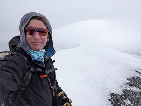
Near the summit Oct 17
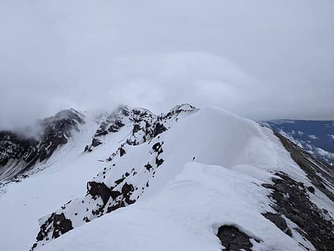
Summit ridge conditions Oct 17
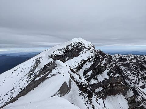
Looking back at the summit
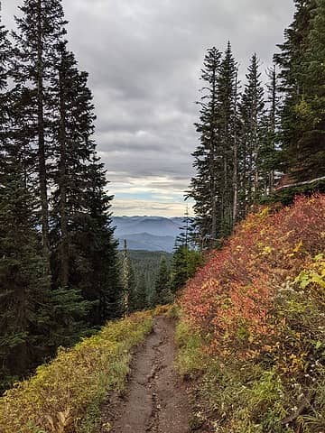
Hiking back down
Hiking back down
When I reached the summit I was unfortunately met with a massive snow drift and cornice. This was not predicted by NOHRSC. It was several feet deep and I hadn’t brought anything to dig it out with. I wasn’t even sure exactly where the summit was under all the snow. It was amazing how favored that particular location is for snow loading. I stopped to take a break and decide what to do, and then another hiker, Zach, arrived. I told him my dilemma and he had an ice axe he said I could use to dig around. I didn’t want to force him to wait up there for an hour while I dug all over the place, and it seemed unlikely I could be certain I’d found the true summit anyways. So I decided to just level out a spot on the highest snow and measure that elevation. That would at least give me an upper bound for the summit elevation, which I could use to get an idea of whether St Helens was still on the WA Top 100 list or not. I set up the unit and started logging data. I also plunged the ice axe down all around the highest snow and didn’t hit rock anywhere, so I figured I could subtract the ice ax height from the measured elevation to get a good upper bound on summit elevation. After an hour I packed up and headed back down. I think all the other hikers had turned around early in the high winds, or turned around at the crater rim. I think in practice few hikers go to the true summit and most turn around at a point 0.4 miles to the east where the main route hits the crater rim. Back at home I checked the weather forecast and the next three days were supposed be sunny and unusually warm. That sounded like a good recipe for melting snow off the summit. Precipitation was supposed to return Saturday and Sunday, but Friday evening looked clear and permits were available. I decided to try again, but this time bring a shovel and avalanche probe. Hopefully the summit would be melted down to rock, but if there was a bit of snow I could probe around to find the summit and then dig out the snow with the shovel.
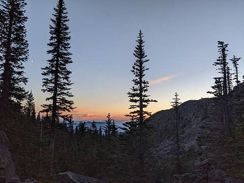
Hiking up Friday evening
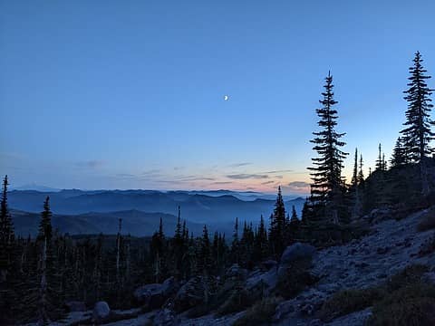
Sunset Friday eve
Sunset Friday eve
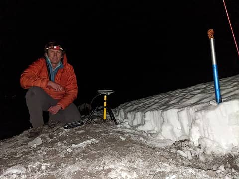
The GPS set up on the summit
I also looked in more detail at the most recent Lidar survey, from 2018. I found the exact coordinates of the highest rock and saved that for use if needed. I bought another permit, then Friday I left immediatly after giving my Dynamics quiz at 2pm and luckily traffic wasn’t too bad. I made good time down to the Climbers Bivouac trailhead and started walking up at 5:45pm. I passed a few people hiking down, but otherwise had the trail to myself. I made above treeline just in time to get some good sunset views, then continued up in the dark. It was a lot warmer this time than back on Tuesday, and luckily less windy. I had still brought a lot of warm clothes for hanging out on the summit. Now the route was completely snow-free to the crater rim, and the drifts I’d remembered were significantly melted back. By 8:45pm I reached the summit, and luckily the highest patch of rocks was melted out now and snow-free. This was a location consistent with the Lidar coordinates I’d saved. The snow drift hadn’t completely melted away, though. So I probed around to verify where the cliff edge started on the north face. Then I dug out all the snow from around the north side of the summit and a bit east and west along the rim. I verified that indeed all other places were lower, and the melted out place was indeed the true summit. At 9:15pm I set up the antenna on the tripod and started logging data. I bundled up in my down jacket and rain pants and started the wait. Luckily it wasn’t too windy. I saw the lights of portland to the south and some red flashing lights to the north from a wind farm. I laid down and tried to take a nap for half an hour, but it was tough since I got cold too quickly. Interestingly I had service on my phone so checked my work email and sent a few messages. I usually like to take a one-hour measurement, but I figured St Helens was important enough to get a 2-hour measurement. The extra hour could cut the measurement error in half. Finally the 2-hour alarm went off at 11:15pm and I packed up and headed down. I made good time down, and actually got just below treeline around midnight. So I was completely legal for my permit. I made it back to the car a bit after 1am, then ate a snack. I had to be back in Seattle by 7am that morning, so unfortunately couldn’t take a nap. I started driving home and made it back by 5am.
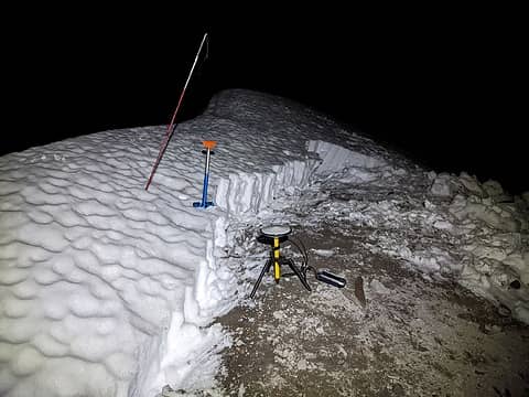
The setup on the summit, looking to the east
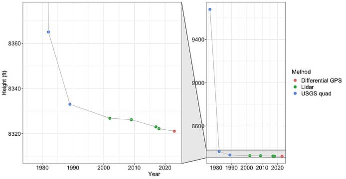
Plot of summit elevation measurements 1979 - 2023 (plot by Katie)
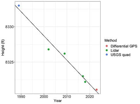
Summit elevation measurements 1989-2023 with linear fit (plot by Katie).
After waiting 24 hours I processed the data using OPUS, the online tool for surveyors provided by NOAA. I found the summit elevation is 8,321.1ft +/-0.2ft. This is 1.1 ft lower than the most recent Lidar measurement from 2018. This means St Helens is too short to qualify for the WA Top 100 list, and is currently at number 102. My current list of the WA Top 100 that I am keeping up to date with each new survey can be found here: https://docs.google.com/spreadsheets/d/1gYaBTa32bLfXiQFrcpTJ58KjO1HIAEEMBDrttHFxUOg/edit#gid=0 Note: Other online sources like Summitpost and Peakbagger.com have not yet completely updated their versions of the WA Top 100 list. The google doc I linked above is the most accurate list to date. I analyzed all recent Lidar data with help from ScramblinRover, and Katie used the data I gathered/measured and made plots showing how the elevation of St Helens has changed over time since the 1980 eruption. It has been consistently losing elevation each time a new measurement has been taken. These are all likely from erosion or wind blowing ash off the summit. Interestingly, all the data from 1989-2023 show a very linear trend in elevation loss (R-squared value 0.98 from an ordinary least-squares regression). The summit is consistently losing 0.34ft/year (4 in/year). Currently the number 103 peak on the list, Switchback Mountain, is only a few inches shorter than St Helens. I suspect in a few years St Helens will drop below Switchback in elevation. Link to more pictures: https://www.countryhighpoints.com/mt-st-helens-survey/

brokein2, Michael Lewis, Now I Fly, Nancyann, call-151, wallorcrawl, williswall, JasonK806, zimmertr, rubywrangler, Scramblin Rover, RichP, John Mac, Alpine Pedestrian, kw, IanB, jaysway, awilsondc, LukeHelgeson
Back to top Reply to topic Reply with quote Send private message
Bosterson
Member
Member


Joined: 12 Sep 2019
Posts: 294 | TRs | Pics
Location: Portland
Bosterson
Member
PostMon Oct 23, 2023 11:43 pm 
Eric Gilbertson wrote:
Interestingly, all the data from 1989-2023 show a very linear trend in elevation loss (R-squared value 0.98 from an ordinary least-squares regression). The summit is consistently losing 0.34ft/year (4 in/year).
That's very interesting. Do you have thoughts about why that would be happening? Since the "summit" is now just a highpoint on the rim, and since the rim is so heavily corniced every winter, could this be from solids getting embedded in the snow and then melting down into the crater? This is an xkcd level nerd question, but I would love to see someone do the math on how long it would take for the crater to "fill in" if 1/3 of a foot of dirt is being lost annually at every point around the rim (this surely isn't happening equally) - and how short the remaining mountain would be at that point. biggrin.gif

Go! Take a gun! And a dog! Without a leash! Chop down a tree! Start a fire! Piss wherever you want! Build a cairn! A HUGE ONE! BE A REBEL! YOU ONLY LIVE ONCE! (-bootpathguy)

Eric Gilbertson
Back to top Reply to topic Reply with quote Send private message
altasnob
Member
Member


Joined: 29 Aug 2007
Posts: 1418 | TRs | Pics
Location: Tacoma
altasnob
Member
PostTue Oct 24, 2023 7:07 am 
Bosterson wrote:
I would love to see someone do the math on how long it would take for the crater to "fill in" if 1/3 of a foot of dirt is being lost annually at every point around the rim (this surely isn't happening equally) - and how short the remaining mountain would be at that point
Have to take into account the crater dome growth as well. Maybe someday the dome can stick up past the crater rim and St Helens can regain its top 100 status.

Eric Gilbertson, zimmertr, jaysway
Back to top Reply to topic Reply with quote Send private message
Eric Gilbertson
Member
Member


Joined: 04 Jul 2018
Posts: 188 | TRs | Pics
Location: Seattle
Eric Gilbertson
Member
PostTue Oct 24, 2023 7:48 pm 
Quote:
Do you have thoughts about why that would be happening?
I agree one reason is because the north face is so steep and loose and that's where the cornices form. In the spring/summer when the snow melts off I bet it brings rocks down with it. Also, I've heard the volcanic ash up there can get blown off with all the wind. The combination must add up to 4 in/year. I'm amazed it's so consistent at 4 in/year, though. That's a very linear trend with six independent measurements. It must be consistent rock quality over depth and very similar weathering every year.

Back to top Reply to topic Reply with quote Send private message
williswall
poser


Joined: 30 Sep 2007
Posts: 1968 | TRs | Pics
Location: Redmond
williswall
poser
PostTue Oct 24, 2023 11:25 pm 
Your surveys are extremely interesting; I enjoy reading these reports very much.

I desire medium danger williswall.com
Back to top Reply to topic Reply with quote Send private message
Gimpilator
infinity/21M


Joined: 12 Oct 2006
Posts: 1684 | TRs | Pics
Location: Edmonds, WA
Gimpilator
infinity/21M
PostTue Oct 31, 2023 7:16 am 
If volcanic forces can cause growth, can the reverse, a lessening of pressure, cause gradual recession? The title of this report made my heart sink a little. Better to know the truth, but this particular volcano is so interesting and significant due to the eruption, its a shame that it fails the cutoff. Still appreciate the information and respect the drive to find the answer. up.gif up.gif

Summitpost | YouTube | Peakbagger

Eric Gilbertson
Back to top Reply to topic Reply with quote Send private message
Michael Lewis
Taking a nap


Joined: 27 Apr 2009
Posts: 629 | TRs | Pics
Location: Lynnwood, WA (for now)
Michael Lewis
Taking a nap
PostSat Nov 04, 2023 3:51 am 
I saw on geology hub that according to USGS Mt St Helens is showing possible signs of the shallow magma chamber 6 km down filling which could change the overall height in the near future. It would be interesting if these measurements indicate anything towards that or could be taken again a year or two from now to see if it resulted in deformation incline or decline. P.M. if you'd like a sherpa. Anyways, it's cool to see your mission unfold here over wild places we are nostalgic for. Your tenacity is a compelling read. Thanks Eric! May your pilgrimage continue to provide enticing data!

Eric Gilbertson
Back to top Reply to topic Reply with quote Send private message
Eric Gilbertson
Member
Member


Joined: 04 Jul 2018
Posts: 188 | TRs | Pics
Location: Seattle
Eric Gilbertson
Member
PostWed Nov 15, 2023 8:31 pm 
Quote:
It would be interesting if these measurements indicate anything towards that or could be taken again a year or two from now to see if it resulted in deformation incline or decline. P.M. if you'd like a sherpa.
I could probably be convinced to take another measurement next year. That would be interesting to keep getting more data. I could definitely use help hauling gear up!

Back to top Reply to topic Reply with quote Send private message
   All times are GMT - 8 Hours
 Reply to topic
Forum Index > Trip Reports > Mt St Helens Survey, Off WA Top 100 List, Oct 20, 2023
  Happy Birthday theCougAbides!
Jump to:   
Search this topic:

You cannot post new topics in this forum
You cannot reply to topics in this forum
You cannot edit your posts in this forum
You cannot delete your posts in this forum
You cannot vote in polls in this forum