| Previous :: Next Topic |
| Author |
Message |
ragman and rodman
Member


Joined: 28 Apr 2005
Posts: 1219 | TRs | Pics
Location: http://rgervin.com/ |
Take the North Fork Teanaway Road a half mile past the De Roux Horse Camp and find trail 1399 on the right side of the road... room for 5 or 6 cars on the left side of the road...
larman joined rodman and me for this hike... our party of three found the trail mostly snow-free until the 4800-5000 foot area... from that point to the 6100 foot saddle between Teanaway Peak (6779) and Iron Peak (6510) we found intermittent snow... too little for snowshoes (yes, we carried them and no, we didn't need them) and too much for a totally enjoyable walk... we dropped the snowshoes at the saddle, turned south, and gained the final 400 feet of elevation (in a half mile) to the summit on reasonably good snow... a dry, but gray day with decent views of the surrounding peaks...
Attached is a picture taken from Iron Peak looking north-northeast across point 6917 to the Stuart Range Peaks of Argonaut, Colchuck, and Dragontail... if anyone knows the name of point 6917, please speak up... point 6917 definitely deserves a name... so, until someone tells us otherwise, we are calling this "nwhikers.net" peak... and of course we are putting it on the to-do list...
Point 6917 and some Stuart Range Peaks (Large File)
Mental note to self - putting one's sunglasses on the ground during a rest break is fine... as long as one remembers to pick them up when the break is over... giving up 150 feet of hard-earned elevation to return for the glasses is very disconcerting...
|
| Back to top |
  
|
|
b00
Member

Joined: 29 Sep 2003
Posts: 1144 | TRs | Pics
|
|
b00
Member
|
 Sat May 07, 2005 9:28 pm |
|
|
i believe the peak is called "bills peak". i was up it a couple of years ago in the spring. we approached it from the bean creek basin - good views, easy snow scramble.
|
| Back to top |
|
|
ragman and rodman
Member
Joined: 28 Apr 2005
Posts: 1219 | TRs | Pics
Location: http://rgervin.com/ |
It's not Bill Peak... we did the Bill Peak/Bean Peak traverse last year... Bill is basically east of Iron Peak... Point 6917 is north northeast of Iron...
|
| Back to top |
|
|
rodman
Member
Joined: 03 May 2005
Posts: 49 | TRs | Pics
|
|
rodman
Member
|
Sat May 07, 2005 9:42 pm GPS Route of Iron Peak Hike
|
|
|
Attached is a GPS route of Ragman's , Larman's and my hike today.
I do not believe that the 6917 ft. peak that Ragman refers to is Bill's Peak.
See attachment
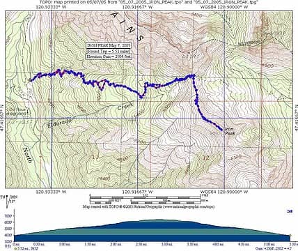 05 07 2005 IRON PEAK-GPS ROUTE
|
| Back to top |
|
|
JimK
Member

Joined: 07 Feb 2002
Posts: 5606 | TRs | Pics
Location: Ballard |
|
JimK
Member
|
Sat May 07, 2005 11:11 pm |
|
|
6917 is Bill Peak. The 75 Scrambles book made a mistake. Bean connects along the ridge to what is often known as Mary Peak. I use Mary Sutliff's Teanaway Country as a source.
Oh, I would have waved at you from Esmerelda Peak if I knew you were on Iron today.
|
| Back to top |
|
|
ragman and rodman
Member
Joined: 28 Apr 2005
Posts: 1219 | TRs | Pics
Location: http://rgervin.com/ |
b and JimK.... thanks for setting us straight on Bill's Peak... Sutliff has Bill's at 6980 feet, but it makes sense after re-reading her description... so, we didn't do the Bill/Bean traverse last year... instead, we did the unnamed bump/Bean Peak traverse... so, we will now refer to the unnamed bump as "nwhikers.net" Peak because it definitely had a peak feel to it...
|
| Back to top |
|
|
Plinko
Member

Joined: 22 Apr 2003
Posts: 214 | TRs | Pics
Location: Seattle-ish |
|
Plinko
Member
|
Mon May 09, 2005 2:00 am |
|
|
| JimK wrote: | | 6917 is Bill Peak. The 75 Scrambles book made a mistake. Bean connects along the ridge to what is often known as Mary Peak. I use Mary Sutliff's Teanaway Country as a source. |
Would that be the same as "Volcanic Neck, 6600'?
|
| Back to top |
|
|
JimK
Member
Joined: 07 Feb 2002
Posts: 5606 | TRs | Pics
Location: Ballard |
|
JimK
Member
|
Mon May 09, 2005 6:57 am |
|
|
Volcanic Neck is at about 6600', located due north of Bean Peak (6743').
Mary Peak is located southwest of Bean at about 6680'. Bill Peak is northwest of Mary across Fourth Creek Pass.
The ridge between Bean and Volcanic Neck is a walk. The ridge between Bean and Mary is a scramble.
The photo below shows Volcanic Neck, Bean Peak, and Mary Peak as seen from Iron Peak to the west:
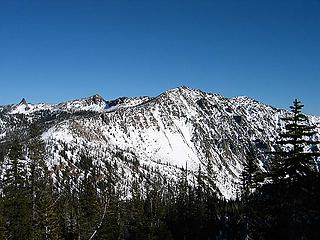 Volcanic Neck, Bean, and Mary Peaks
|
| Back to top |
|
|
ragman and rodman
Member
Joined: 28 Apr 2005
Posts: 1219 | TRs | Pics
Location: http://rgervin.com/ |
Goldman's 75 Scrambles book is actually correct in its description of doing Bill, Bean, and the Volcanic Neck (Hike 55 in her book)... see the map below... we just messed it up last year when we got to the 5500 foot saddle via trails #1391 and #1218... at the saddle, instead of heading northwest towards the real Bill Peak (6917), we turned southeast and headed for the ridge that connected to Bean Peak and the Volcanic Neck...
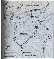 Bill, Bean, Volcanic Neck Map
|
| Back to top |
|
|
JimK
Member
Joined: 07 Feb 2002
Posts: 5606 | TRs | Pics
Location: Ballard |
|
JimK
Member
|
Mon May 09, 2005 7:42 am |
|
|
It would appear that the revized edition of the book is now correct. This is what the original version showed:
|
| Back to top |
|
|
ragman and rodman
Member
Joined: 28 Apr 2005
Posts: 1219 | TRs | Pics
Location: http://rgervin.com/ |
I wish we could use the excuse that we had the older version of the book, but we can't... Goldman also says that there are no views of Mt. Rainier from Marcus Peak and The Palisades which is incorrect... however, after all is said and done, I'm glad folks like Sutliff and Goldman chose to write the books...
|
| Back to top |
|
|
|
|


