| Previous :: Next Topic |
| Author |
Message |
geyer
Member


Joined: 23 May 2017
Posts: 463 | TRs | Pics
Location: Seattle |
|
geyer
Member
|
 Tue Oct 31, 2023 7:34 pm |
|
|
Dates: October 28-29, 2023
Distance: ~27 miles
Accum. Elevation Gain: 7600'
Lakes: Fisher, Lower Ptarmigan, Clarice, Marmot, No Name, Jade
Total Humans Seen: 4
I like seeing lakes before they've frozen after a fresh snowfall, so what better lake to go see than Jade? I was convinced that last week's snows had buried everything and travel would be difficult. My pack weighed 50 lbs and I threw snowshoes in my car just in case. I wasn't even sure if Salmon La Sac would be driveable so I got creative with a route that really wasn't all that bad on paper and about 75% trail mileage. The weather forecast said wind chills would be in the single digits, so I didn't go light on the layers.
Day 1
Distance: 10.3 miles + 0.7 miles of forgetting that my car was unlocked
Elevation Gain: 4100' // -2800
Instead of heading to the deception Creek trail, I went to the Foss River Road and expected to have to bushwack near Burn Creek at 2000 ft elevation. Instead, I noticed melted out south and west facing slopes so I tried out the road up to Tonga Ridge... and it went all the way to the trailhead with zero snow. Already, my expectations were shattered, so I left the snowshoes in the car and began the trip wearing trail runners of all things, carrying boots and gaiters for the long haul. About 7 minutes in, I realized I left my car unlocked, so I ran back to lock it up, adding 1/3 mile each way. The trail was mostly untouched except of a number of deer prints and a bobcat track that I followed for about a mile. About 3 miles in at the meadows between Mount Sawyer and Fisher Lake is where the snow got shin deep, so I switched the runners for boots and threw gaiters on. Boots are the worst, man.
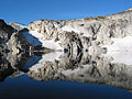
Fisher lake was a great place to stop and eat my first slice of leftover frozen pizza. With the sun out, the temps were not only tolerable, but quite pleasant in a light jacket. I pressed onward and followed a faint trail to the Ptarmigan Lakes where the lighting was fantastic, so I stopped to take a few pictures of the island.
The trail stopped after Ptarmigan Lakes, but the terrain was extremely easy to follow. However, the ground was frozen solid and the snow was fluffier than a cocaine habit, so any vertical travel that wasn't assisted by rocks or roots was a surefire way to fall on my butt. Or my batongadonk as I started calling it.
The ridge above Lake Clarice was wide open meadow with unobstructed views of Lake Clarice, Dip Top Gap, and Daniel. If the ground had not been frozen, there probably would have been some good choss skiing directly down to the lake. However, I took the ridge down and wound up in alder hell, which was more like alder purgatory compared to some of the alder dungeons of doom I've found myself in. But, hey, I've gotta make a good story out of this, you know? Approximately 80% of the trip's F-bombs were dropped in this vicinity.
I was glad to be out of there and back on a trail with only about 3miles of on-trail hiking remaining until reaching Jade Lake. For the first time since near the trailhead, I was following bootprints again. The mystique of being alone in nature was suddenly noticeably absent even though I had not yet seen anyone. At Marmot Lake, I ran into a guy who turned around when he got to the boulder field ascent up to Jade. I don't blame him - my friend once told me a story of a guy who ruptured his Achilles trying to hike a boulder field covered in a dusting of snow and I try to be extra cautious because of that. (Just not cautious enough to turn around, I guess). Another group started following me up my wonky route to Jake Lake, but must have turned around and stayed at Marmot.
So far, aside from the vegetation around Lake Clarice, my one complaint on the day was that the route really wasn't all that alpine. But the hike from the top of the boulder field to Jade lake finally changed that. The air was crisp, the snow was light as air and made a distinct swishing sound every time I took a step, and there was not even a hint of wind to elude the palpable silence. But also, my feet were starting to get wet, the sun was close to setting, and I wanted to get in my sleeping bag more than anything.
I set up my tent. Took off my wet boots, gaiters, pants, and socks. Replaced them with dry wool long johns, a new pair of OR bibs that I got from the outlet store this season for like 80% off retail, a wool upper base layer, a new pair of wool socks, a light puffy, and a heavier puffy. Then I slipped myself into a sleeping bag liner and got into the zero degree bag. From there, I made dinner in my tent vestibule and went to bed. The only time I unzipped anything - tent, pants, and sleeping bag included - was to roll sideways 90 degrees and pee outside the tent door while still half cocooned. Perks of (male) solo camping I guess?
Day 2:
Distance: 17 miles
Elevation Gain: +3300' // -4600'
I kept wondering in the back of my mind, when those single digit wind chills were going to kick in. So far there had hardly been a whisper of wind. After I hit the hay, I started to hear these gales whipping at the ridges and treetops. But somehow, the lower elevations of this bowl were spared. Thank goodness, because I was barely warm and a little wind would have thrown that into peril.
I talked up a big game before departing on this trip and told myself that I'd camp at Dip Top Gap, or get up early and make a sunrise ascent of Dip Top Peak. But once I was in the sleeping bag, all bets were off. My one true motivation was to not leave this position of warmth until the sun had risen. Adding to that, I decided that I also did not want to return the way I had come. It wasn't that the route was exceptionally difficult or anything. Just like a strong physical game, a strong mental game needs to be built up - and I had been relatively soft all year in the mental department. There wasn't a strong desire to keep falling on my butt on frozen ground and battling alder bush past Lake Clarice. So instead, I decided I would go the long way on trail which was roughly 7 miles longer. I had trail ran 17 miles the week before, but hauling 50 lbs for 17 miles - in mountaineering boots - was not something I was looking forward to. Still better than the Clarice F-bombs, I suppose.
In the morning, I woke up around 7:30 and was too cold to want to make breakfast, so I ate a pack of Ritz crackers. I got out of bed around 8am, snapped a couple of pictures, and began to take down camp. I was wearing the trail runners because the snow was already compacted and did not want to put the boots on until I had to. I was nearly all packed and decided it was time to but the boots on. Except for one problem - they were frozen shut. I couldn't fit my feet into them. Too cold to think straight, I panicked for a minute, thinking I might have to hike all the way through the deeper snow in trail runners. Then I had the idea to get out my stove and roast my boots like marshmallows over an open flame. This did the trick, but my feet were instantly numb from the cold/wet. Luckily I was wearing waterproof socks (my 3rd pair of socks brought on the trip) so I was able to regulate moisture and my feet were back to feeling probably 30 minutes later.
There was some wonderful lighting the valley leaving Marmot Lake and heading to the SE. I stopped for water near the refreshing creek just north of the tarns SW of the Blue Ridge pass. The PCT and Depetion Creek Trail were completely untouched but easy to follow and quite peaceful at times. But not so when the Deception Creek trail needlessly decided to climb 300 feet away from the creek up to Deception Lakes. At this point, I decided my feet were hurting enough and the snow was melted enough that I would finish the last 6 miles in trail runners.
The final 1600' climb back up to Tonga Ridge was brutal, but I tuned it out by listening to Alex Honnold crone about risk in his Climbing Gold podcast. I don't usually listen to things when I'm out on the trail, so if I do, it usually means I'm tired of hiking - or more likely, tired of my mind repeating the same thought for the hundredth time in a row. The sun went down and it was torturously pink and orange behind the ridgeline canopy with no clearings in sight. At about 6:20pm, I arrived back at the car.
 Waterman, wallorcrawl, contour5, runup, jsb, kw, Nancyann, Dustin R, fourteen410, solohiker, Tom, Schroder, Now I Fly, zimmertr, Route Loser, jaysway, hikerbiker, John Mac, reststep, BigBrunyonEnjoyerAI, rubywrangler, RichP Waterman, wallorcrawl, contour5, runup, jsb, kw, Nancyann, Dustin R, fourteen410, solohiker, Tom, Schroder, Now I Fly, zimmertr, Route Loser, jaysway, hikerbiker, John Mac, reststep, BigBrunyonEnjoyerAI, rubywrangler, RichP  GaliWalker GaliWalker  SpookyKite89 SpookyKite89
Waterman, wallorcrawl, contour5, runup, jsb, kw, Nancyann, Dustin R, fourteen410, solohiker, Tom, Schroder, Now I Fly, zimmertr, Route Loser, jaysway, hikerbiker, John Mac, reststep, BigBrunyonEnjoyerAI, rubywrangler, RichP GaliWalker SpookyKite89 |
| Back to top |
  
|
|
rubywrangler
Member

Joined: 04 Aug 2015
Posts: 511 | TRs | Pics
|
| geyer wrote: | | to roll sideways 90 degrees and pee outside the tent door while still half cocooned |
I am so jealous of this ability
fourteen410, BigBrunyonEnjoyerAI  geyer geyer
fourteen410, BigBrunyonEnjoyerAI geyer |
| Back to top |
|
|
jaysway
Member

Joined: 16 Jul 2020
Posts: 348 | TRs | Pics
|
|
jaysway
Member
|
Wed Nov 01, 2023 10:37 am |
|
|
I love this, I had never seen views of Jade Lake looking so stark in a thin blanket of snow nor have I heard of someone getting to Jade Lake from Tonga Ridge. My favorite photo is of the island in Ptarmigan Lake!
SpookyKite89, geyer
SpookyKite89, geyer |
| Back to top |
|
|
geyer
Member
Joined: 23 May 2017
Posts: 463 | TRs | Pics
Location: Seattle |
|
geyer
Member
|
Wed Nov 01, 2023 10:59 am |
|
|
| jaysway wrote: | | I love this, I had never seen views of Jade Lake looking so stark in a thin blanket of snow nor have I heard of someone getting to Jade Lake from Tonga Ridge. My favorite photo is of the island in Ptarmigan Lake! |
I was a little bummed I didn't get to see the lake lit up in daylight, but I agree, those tree scenes turned out nice!
|
| Back to top |
|
|
Tom
Admin
Joined: 15 Dec 2001
Posts: 17857 | TRs | Pics
|
|
Tom
Admin
|
Wed Nov 01, 2023 4:47 pm |
|
|
That's a fun area to explore going in the way you did, done it twice, once up to Terrace and looping out high above Clarice back to the car, as well as to Jade, looping out the Necklace on that trip. That's a long way out via Deception Creek!
geyer
geyer |
| Back to top |
|
|
Malachai Constant
Member

Joined: 13 Jan 2002
Posts: 16097 | TRs | Pics
Location: Back Again Like A Bad Penny |
We did it once as Tom described. The descent from Terrace direct to Marmot was spicy.
"You do not laugh when you look at the mountains, or when you look at the sea." Lafcadio Hearn
geyer
"You do not laugh when you look at the mountains, or when you look at the sea." Lafcadio Hearn
geyer
|
| Back to top |
|
|
Dustin R
veteran rookie
Joined: 30 Aug 2017
Posts: 21 | TRs | Pics
Location: Seattle |
|
Dustin R
veteran rookie
|
Thu Nov 02, 2023 4:11 pm |
|
|
Love that zone above Clarice. Went in the same way this summer with the intention of connecting to the Tanks and out the West Fork Foss, but got decimated by that heat wave the day we started the trip. Could not fathom retracing our steps back from our bailout point at Jade, we ended up motoring out Deception Creek as well. That final climb back to the car in the early afternoon heat nearly cooked us, whoever built that trail really wanted to get to the ridge! Our group was hit by ground hornets climbing up from Ptarmigan Lake, and on the way out along Deception Creek. Not sure I'll revisit that route again 
geyer
geyer |
| Back to top |
|
|
timberghost
Member

Joined: 06 Dec 2011
Posts: 1333 | TRs | Pics
|
Having done several long day hikes from the end of Tonga Ridge (route to be kept myself) to Pea soup I found it to be quite enjoyable. Of coarse this was before Marmot and Jade became a internet attraction. It was always nice to be the only one up there. Times have changed and the world has moved on.
geyer
geyer |
| Back to top |
|
|
geyer
Member
Joined: 23 May 2017
Posts: 463 | TRs | Pics
Location: Seattle |
|
geyer
Member
|
Fri Nov 03, 2023 8:41 am |
|
|
I figured others around here had taken similar routes before. (I'm in good company  .) I drew a few options before heading out and the route I took was labeled "option 6" on my planning map. So there are a lot of options to be had around there. Those ridge traverses look like they would be a nice option in summer. A little too spicy with the fresh snow .) I drew a few options before heading out and the route I took was labeled "option 6" on my planning map. So there are a lot of options to be had around there. Those ridge traverses look like they would be a nice option in summer. A little too spicy with the fresh snow
Dustin R
Dustin R |
| Back to top |
|
|
Jason Hummel
Member
Joined: 31 Aug 2006
Posts: 1209 | TRs | Pics
Location: Tacoma Washington |
Nice. I went this way and beyond with my brothers this summer, and spent a week out there on a longer traverse. Love the area.
Here's Pea soup and area in winter.
|
| Back to top |
|
|
Sky Hiker
Member
Joined: 03 Feb 2007
Posts: 1469 | TRs | Pics
Location: outside |
A pretty area. I like the Terrace Mtn and lakes area and chance to escape some people.
|
| Back to top |
|
|
eishundo
Member
Joined: 11 Jul 2013
Posts: 5 | TRs | Pics
|
|
eishundo
Member
|
Tue Jan 30, 2024 6:12 pm |
|
|
|
| Back to top |
|
|
geyer
Member
Joined: 23 May 2017
Posts: 463 | TRs | Pics
Location: Seattle |
|
geyer
Member
|
Tue Jan 30, 2024 6:30 pm |
|
|
And the second one is neither jade nor (much of) a lake
|
| Back to top |
|
|
|
|
You cannot post new topics in this forum
You cannot reply to topics in this forum
You cannot edit your posts in this forum
You cannot delete your posts in this forum
You cannot vote in polls in this forum
|
Disclosure: As an Amazon Associate NWHikers.net earns from qualifying purchases when you use our link(s). |


