| Previous :: Next Topic |
| Author |
Message |
rubywrangler
Member


Joined: 04 Aug 2015
Posts: 516 | TRs | Pics
|
I finally left southern AZ in early April to begin my meandering journey back to Seattle. First stop on the scenic route was Marble Canyon for a few hikes and a paddle.
Rider Canyon, GCNP 4.14.24
Shelby and I met on Hwy 89A and left her car at the turnoff to the BLM road to the trailhead. This road was definitely the crux of the day. The 14 mile drive from the highway to the trailhead took nearly an hour and was very nerve-wracking, but the CR-V made it with only a couple minor scrapes and bumps, and an undercarriage full of grass that I sheared off from the center strip in the road.
The trail drops into a chute with a little fun scrambling for a hundred feet or so, then descends a loose slope for another ~1000 feet. Once in the streambed, there was a short bit of gravelly wash-walking before we hit slickrock in the Supai. We encountered a few fun bypasses and many pretty pools. One knee-deep wade was required. Toward the river, the canyon got narrow and even more stunning. We took a long break at the beach at house rock rapid before retracing our steps out. This is a really lovely and very fun hike - it packs a lot into <6 miles! And it was so nice to only have to climb 1000 feet out instead of 5000!
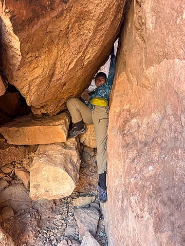 tight squeeze 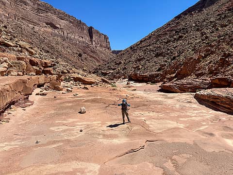 rider canyon slickrock 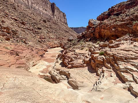 continuing downstream 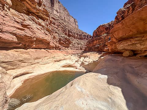 pretty pools 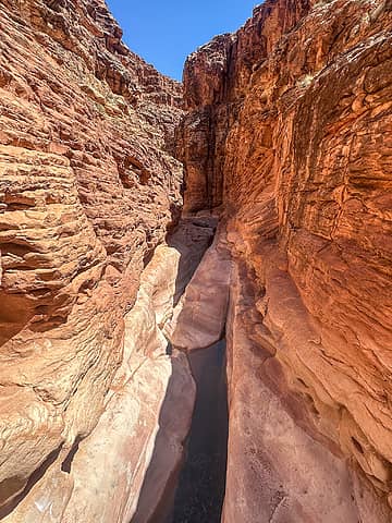 narrowing (bypass on left here) 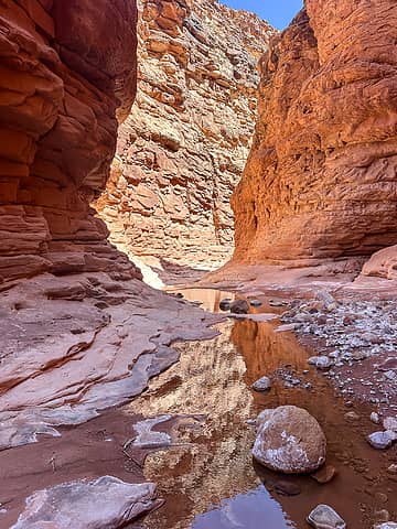 in the narrows 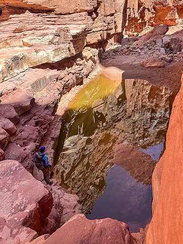 the wader 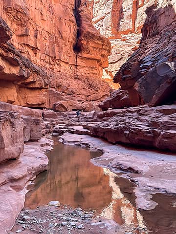 just past the last bypass 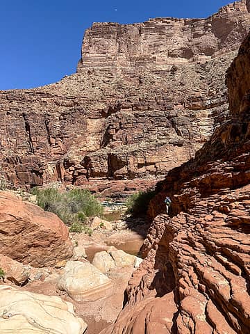 leaving the river 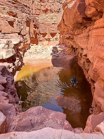 wading back upstream  We left early to avoid the heat and so I could check on my dad, who was having surgery that morning, and we again appreciated the short climb out of the canyon! We left early to avoid the heat and so I could check on my dad, who was having surgery that morning, and we again appreciated the short climb out of the canyon!
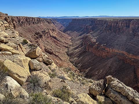 south canyon from the rim 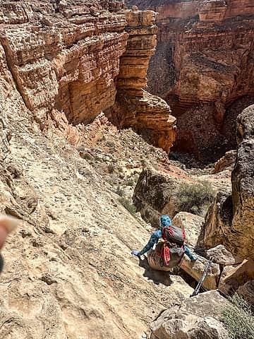 scramble descent 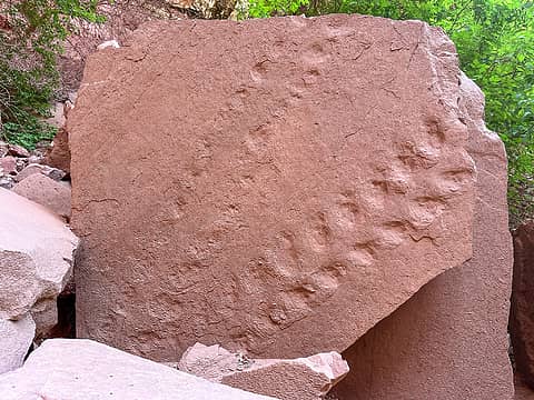 tracks 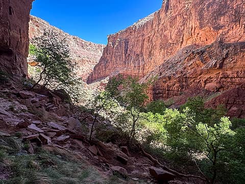 in the amphitheater 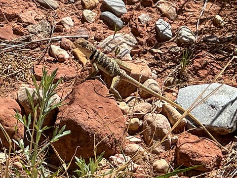 first of a million 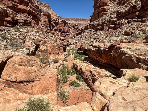 above another pouroff 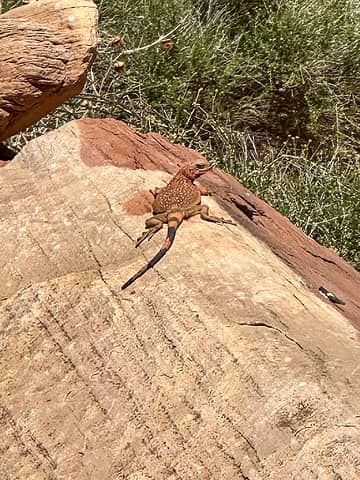 splooting 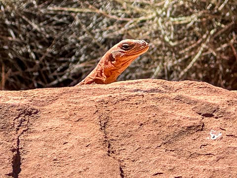 spying 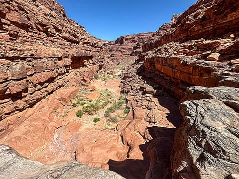 bypass on right here 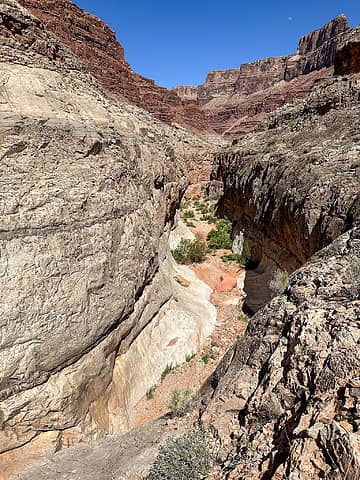 beginning of the redwall narrows 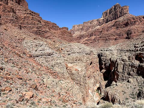 high bypass view 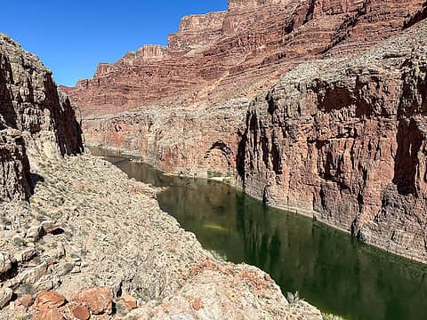 almost to the river 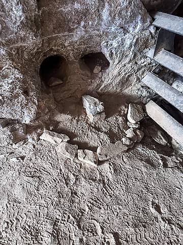 stanton's cave 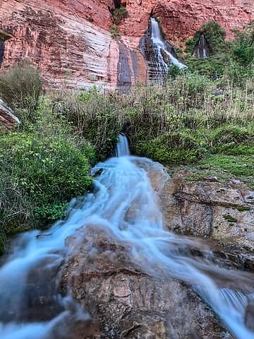 vesey's paradise 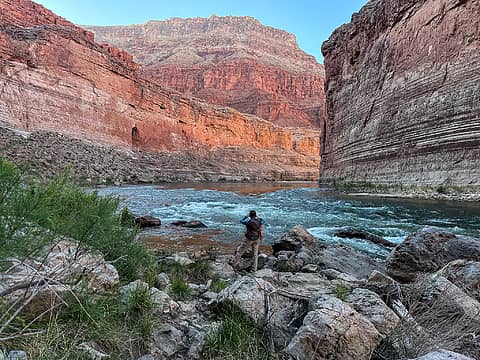 upstream view from vesey's 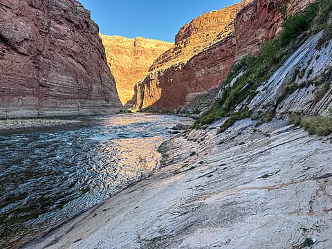 downstream view 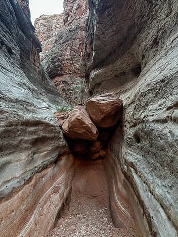 bottom of the narrows, looking up 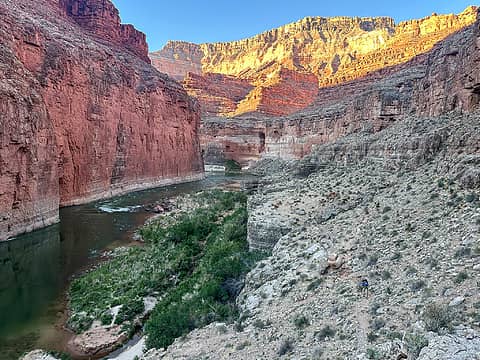 leaving the colorado  back across a bypass 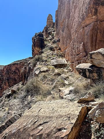 exit ramp  Along the way we stopped to check out petroglyphs, some springs, and a couple side canyons. We camped at 9 mile, which is a pretty spot but directly below horseshoe bend, so we had an audience until sunset and again starting at sunrise. That was odd.
North fork soap creek, GCNP 4.24.24
This one intrigued me from the highway so I checked it out one afternoon on my way to Cliff Dwellers restaurant for dinner (highly recommend). I probably only went 1 mile +/- before I came to a couple-hundred foot pouroff that required canyoneering gear to descend, but it was a very scenic mile! Along the way we stopped to check out petroglyphs, some springs, and a couple side canyons. We camped at 9 mile, which is a pretty spot but directly below horseshoe bend, so we had an audience until sunset and again starting at sunrise. That was odd.
North fork soap creek, GCNP 4.24.24
This one intrigued me from the highway so I checked it out one afternoon on my way to Cliff Dwellers restaurant for dinner (highly recommend). I probably only went 1 mile +/- before I came to a couple-hundred foot pouroff that required canyoneering gear to descend, but it was a very scenic mile!
 GaliWalker, Now I Fly, shelby147, jstern, Nancyann, John Mac, Prosit, olderthanIusedtobe, neek, NWtrax GaliWalker, Now I Fly, shelby147, jstern, Nancyann, John Mac, Prosit, olderthanIusedtobe, neek, NWtrax  kite, awilsondc, canadug kite, awilsondc, canadug  fourteen410 fourteen410  Gimpilator Gimpilator
GaliWalker, Now I Fly, shelby147, jstern, Nancyann, John Mac, Prosit, olderthanIusedtobe, neek, NWtrax kite, awilsondc, canadug fourteen410 Gimpilator |
| Back to top |
  
|
|
neek
Member

Joined: 12 Sep 2011
Posts: 2350 | TRs | Pics
Location: Seattle, WA |
|
neek
Member
|
 Fri May 03, 2024 4:17 pm |
|
|
great scenery. cool lizards. looks like we missed you at the grand canyon by about a week.
rubywrangler
rubywrangler |
| Back to top |
|
|
canadug
Member

Joined: 25 May 2007
Posts: 112 | TRs | Pics
Location: Canada |
|
canadug
Member
|
Fri May 03, 2024 4:22 pm |
|
|
Fabulous TR!!
rubywrangler
rubywrangler |
| Back to top |
|
|
olderthanIusedtobe
Member
Joined: 05 Sep 2011
Posts: 7733 | TRs | Pics
Location: Shoreline |
| rubywrangler wrote: | splooting |
I don't think I've ever encountered the term splooting before, but I recognize the pose. Have seen marmots and California ground squirrels employing this.
|
| Back to top |
|
|
rubywrangler
Member
Joined: 04 Aug 2015
Posts: 516 | TRs | Pics
|
John Mac  Now I Fly, fourteen410, olderthanIusedtobe Now I Fly, fourteen410, olderthanIusedtobe
John Mac Now I Fly, fourteen410, olderthanIusedtobe |
| Back to top |
|
|
Roly Poly
Member
Joined: 02 Jan 2013
Posts: 714 | TRs | Pics
|
Gorgeous scenery. Thanks for posting!
rubywrangler
rubywrangler |
| Back to top |
|
|
olderthanIusedtobe
Member
Joined: 05 Sep 2011
Posts: 7733 | TRs | Pics
Location: Shoreline |
Language keeps evolving. I'm often behind on words or phrases that come into existence.
|
| Back to top |
|
|
olderthanIusedtobe
Member
Joined: 05 Sep 2011
Posts: 7733 | TRs | Pics
Location: Shoreline |
I think there is one more kind of splooting--the mobile sploot. Dogs do it and then drag themselves forward with their front paws.
rubywrangler
rubywrangler |
| Back to top |
|
|
Nancyann
Member
Joined: 28 Jul 2013
Posts: 2334 | TRs | Pics
Location: Sultan Basin |
|
Nancyann
Member
|
Sat May 04, 2024 10:53 am |
|
|
Wonderful pictures and trip report, thanks for taking the time to share it all!
rubywrangler
rubywrangler |
| Back to top |
|
|
Eric Hansen
Member
Joined: 23 Mar 2015
Posts: 883 | TRs | Pics
Location: Wisconsin |
+1! Marble Canyon is good medicine. 
|
| Back to top |
|
|
|
|
You cannot post new topics in this forum
You cannot reply to topics in this forum
You cannot edit your posts in this forum
You cannot delete your posts in this forum
You cannot vote in polls in this forum
|
Disclosure: As an Amazon Associate NWHikers.net earns from qualifying purchases when you use our link(s). |


