| Previous :: Next Topic |
| Author |
Message |
Beave
Member


Joined: 21 Dec 2001
Posts: 276 | TRs | Pics
Location: Woodinville |
|
Beave
Member
|
 Sun Jul 03, 2005 1:41 pm |
|
|
Once part of a larger Mt Rainer, Little Tahoma now stands as an eroded, satellite peak and definitely deserves separate recognition, not only as its own peak, but also as the 3rd highest mountain in the state. Another thing it deserves is the reputation for it having very loose and friable rock. It is as if someone drenched this peak in an acid bath. Every step starts a slide and most handholds can be pulled off. This is a mountain that could collapse tomorrow and I wouldnt be surprised.
Climbing Little Tahoma in a day obviously takes some time, so we (Randy B., Shella, Bernie and Dennis) opted to take advantage of the nearby White River campground so we could get an early jump-off Saturday morning. Its a cool campground that I would recommend if in the area. We were surprised to see empty spots on Independence Day weekend.
At 6am Saturday morning, the 5 of us took off from the Fryingpan Creek TH destined for Summerland, 4.1 miles up the trail. The weather was very gloomy and we could hardly see across the creek with all the low clouds. It began misting at one point, but we never did get rained on. After passing the shelter at Summerland, we ditched our trail shoes and trekking poles in the bushes and donned boots and axes for the remainder of the ascent. Personally, my spirit was a little low at this point. It seemed like too big of a mountain and too dangerous a route to be climbed in a total whiteout. But, we slogged on, jogging to the right of cliffs (that we couldnt see) up to Meany Crest and picking up the high camp just before jumping on the Fryingpan Glacier. We had all brought glacier gear and enough rope for two teams, but decided against roping up due to the lack of visible danger and the sound firmness of snow. (Although, if one looks in the brown Beckey Guide, the Fryingpan Glacier is photographed and looks to be quite active. Just because we didnt rope, doesnt mean you wont have to.)
The gentle contours of the Fryingpan Glacier were a welcome relief. At around 8500 we entertained a few sucker-holes eluding to blue skies and we finally got a couple glimpses of our objective. As we neared the 9000 gap that leaves the Fryingpan Glacier and enters the Whitman Glacier, we witnessed Little Ts reputation first hand when a decent size snow and rock slide came crashing down a couple hundred yards from us. The gap above looked like one of the safest places to be so we all wasted no time getting there.
The Whitman Glacier looked just as tame as the Fryingpan, so again we opted not to rope up and began a rising traverse toward the far end of the glacier and up to its upper terminus. During this process, we crossed a handful of nasty looking holes that were just beginning to melt out and become too sketchy to walk over un-roped. At about 10,500 we dropped packs an ascended another snow-slope with an icy rock step. Now in a series of gullies and off snow for the most part, we really began enjoying Little Ts rock qualities. We had a very safety conscious crew of 5, but even that was a large party for this section of the climb. I almost got my hand crushed when another party member was above me and started a large section of large rocks sliding my way. Helmets were designed for peaks like this!!
We were fortunate enough to get another sustained cloud break and then figure out which tower was the true summit. We were just looking for the quickest way up, so I think our final route varies from most. Still on the SE side, we found a 30 chimney leading to the summit. One member was kind enough to lead it unprotected, set up a top-rope, and belay the other 4 of us up. The climbing was low 5th class but still on very undesirable rock. Upon reaching the summit, everyones reaction was the same; Jaw-dropping!! WOAH!! Mt Rainer is in your face!! I could see the entire DC Route, from Camp Muir to summit. Even little ant people were visible along various parts of the route. The clouds had now subsided to about the 9000 foot level and Mt Adams was seen poking its head through. I felt a good sense of accomplishment as only the 3 highest mountains in the state were visible above the clouds, and Id been to the top of each of them.
The summit was just big enough for our team of 5, and we relaxed while replacing worn rappel slings and enjoying the views. I took a peek over the NW side and the wind was howling up from the glacier below. It was so strong it literally made the summit feel wobbly. The rappel back down the chimney was uneventful until a melon-sized rock from above was dislodged by the rope and smashed my hand against the chimney wall; Ouch!!! A tattered thumb and a bruised knuckle bone were the price paid for that one. The rest of the descent of the summit rocks was well handled by having a staggered group which minimized the danger to each other.
The rest of the descent was as good as it gets. We glissaded the upper snow slopes and the Whitman Glacier to 9100, traversed over to the 9000 gap, glissaded down to 8500 on the Fryingpan Glacier, (now back in the clouds) slogged for a few, glissaded to Meany Crest and finally, glissaded the last 1500 almost non-stop back into Summerland. There was a smile on everyones face by the end of that one!! After putting our trail shoes back on and enjoying all the clear views we missed during the cloudy morning, we cranked out the last 4 miles to the TH and arrived at 8pm.
7500 of gain, 16 miles RT, 14 hours car-to-car
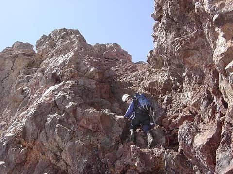 Summit Gully 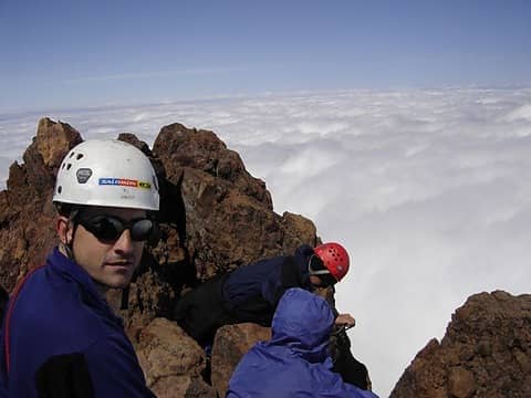 Randy B on Little T 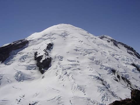 Big T from Little T 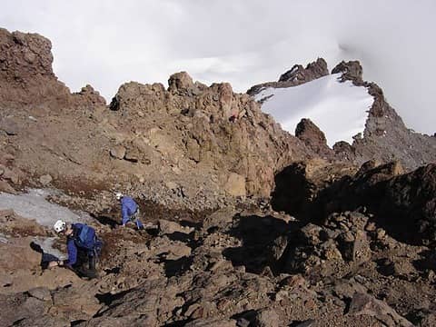 Descent 1 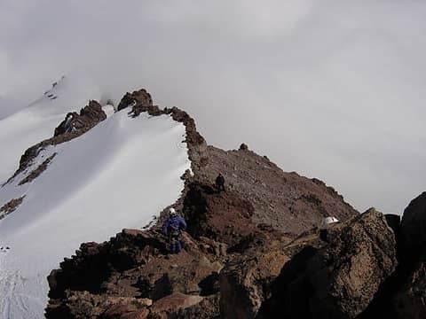 Descent 2 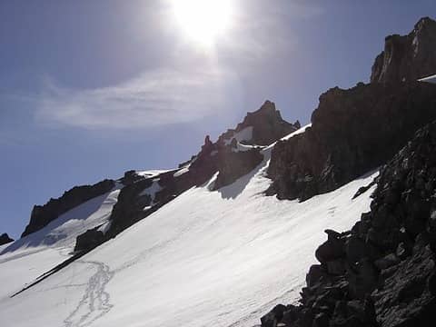 Little T from 9000' gap 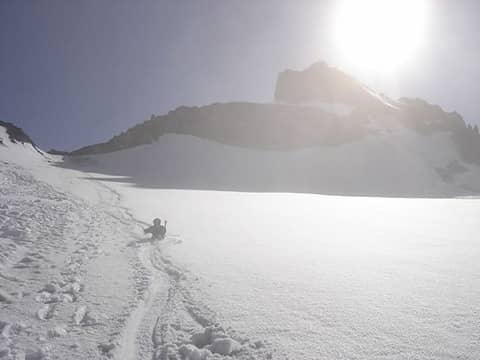 Glissading Fryingpan from Gap 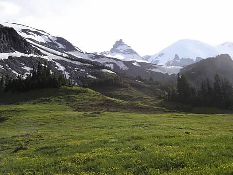 Little T from Summerland
|
| Back to top |
  
|
|
Edd
Member

Joined: 23 Jun 2003
Posts: 296 | TRs | Pics
|
|
Edd
Member
|
Sun Jul 03, 2005 9:57 pm |
|
|
Thanks for the report and pics. Spent today dinkin around the emmons morain, and glacier basin with my son. I kept thinking how knarly, (for lack of better words), little tahoma looked, compared to big T.
|
| Back to top |
|
|
Blue Dome
Now with Retsyn

Joined: 12 Aug 2004
Posts: 3144 | TRs | Pics
Location: Cleaning up the dogma. |
|
Blue Dome
Now with Retsyn
|
Sun Jul 03, 2005 10:05 pm |
|
|
I've heard the final ascent is a bowling alley. Well written trip report and nice pics, thanks. 
I never give them hell. I just tell the truth and they think it's hell.
Harry S. Truman
I never give them hell. I just tell the truth and they think it's hell.
Harry S. Truman
|
| Back to top |
|
|
Randy
Cube Rat

Joined: 18 Dec 2001
Posts: 2910 | TRs | Pics
Location: Near the Siamangs |
|
Randy
Cube Rat
|
Mon Jul 04, 2005 12:06 am |
|
|
Thanks for putting together the report on this one - it must have hurt like hell given your thumb issues  . As usual, good stuff and good pictures! . As usual, good stuff and good pictures!
|
| Back to top |
|
|
Beave
Member
Joined: 21 Dec 2001
Posts: 276 | TRs | Pics
Location: Woodinville |
|
Beave
Member
|
Mon Jul 04, 2005 11:24 am |
|
|
Yes, I think we all earned our "Chossmaster" merit badges on this one. This peak rates #1 for my no-repeat list.
|
| Back to top |
|
|
Tazz
Member

Joined: 27 Apr 2005
Posts: 7902 | TRs | Pics
|
|
Tazz
Member
|
Mon Jul 04, 2005 2:33 pm |
|
|
Very nice work guys
sorry about your thumb.
|
| Back to top |
|
|
hopalong
Tree Climber

Joined: 03 Mar 2004
Posts: 732 | TRs | Pics
Location: Edmonds |
|
hopalong
Tree Climber
|
Mon Jul 04, 2005 5:37 pm |
|
|
|
| Back to top |
|
|
Stefan
Member

Joined: 17 Dec 2001
Posts: 5093 | TRs | Pics
|
|
Stefan
Member
|
Tue Jul 05, 2005 9:08 am |
|
|
|
| Back to top |
|
|
Guiran
Member
Joined: 03 Mar 2004
Posts: 621 | TRs | Pics
Location: University of Washington |
|
Guiran
Member
|
Tue Jul 05, 2005 10:07 am |
|
|
Awesome!
|
| Back to top |
|
|
wolfs
Member
Joined: 07 Oct 2004
Posts: 302 | TRs | Pics
|
|
wolfs
Member
|
Tue Jul 05, 2005 5:18 pm |
|
|
Nice pix. I've looked at Little T a couple of times from Whitman Crest. Every time that I do, I always think to myself "I'm not gonna climb THAT!" because from there it looks really steep cuz of foreshortening; in particular the off snow part. But your pix give a much more realistic assessment of the angle - nasty but doable. Maybe I'll climb that big lumpa choss some time after all ... I was up on the lower part of the Fryingpan Glacier last weekend and snow was very unconsolidated and was glad I was wearing skis; the party I saw at Meany Crest camp reported serious wallowing which caused bailage on a summit attempt on June 25. Hope you had better consolidation or at least a nice pre-deepened trench!
Re: the crevasses. I've been up on the Fryingpan Glacier a couple of times now, to climb as far as Whitman Crest and ski back down. That Brown Fred picture of the glacier is indeed alarming. But I think there are a number of cases in CAG where the picture he has are totally worst case scenarios of the crevasse patterning on the glaciers. My theory is that often these were obtained from Austin Post and other glaciologists/geographers for whom a nastily crevassed glacier was more interesting, and that the pictures may well have been taken in October or some other time where the last winter's blanket had completely melted off. As a ski run, it's a great run and I've not seen any crevasses the last 2 July's anywhere close enough to the direct run to Whitman Crest. to cause concern. Last year I think I did see a few suspect spots below the big schrund series that opens up just under the biggest rocks of Whitman Crest, as you approach 9K saddle. There are a lot more at the breakovers below that area, as visible from the Frypan Ck bridge. From Whitman Crest I've seen more prominently patterned crevasses on the Whitman but these are typically babies no more than a couple of feet across and mostly below the little T route.
|
| Back to top |
|
|
Beave
Member
Joined: 21 Dec 2001
Posts: 276 | TRs | Pics
Location: Woodinville |
|
Beave
Member
|
Tue Jul 05, 2005 10:03 pm |
|
|
Thanks for the crevasse info Wolfs. Thats too bad for the party that had to bail on the 25th due to wallowing. While we didn't have a trench, the snow was very supportive and we were lucky enough to scoot right across it without difficulty.
I envy your skiing!! Knowing how good the glissading was, I can't even imagine how much fun it would be to throw some turns down up there.
Beave
|
| Back to top |
|
|
|
|
You cannot post new topics in this forum
You cannot reply to topics in this forum
You cannot edit your posts in this forum
You cannot delete your posts in this forum
You cannot vote in polls in this forum
|
Disclosure: As an Amazon Associate NWHikers.net earns from qualifying purchases when you use our link(s). |


