| Previous :: Next Topic |
| Author |
Message |
Joe
Member

Joined: 29 Jun 2002
Posts: 819 | TRs | Pics
Location: Kent |
|
Joe
Member
|
 Sun Aug 28, 2005 8:44 am |
|
|
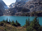
This trip started with a 5.5 mile hike up the Moraine Park trail (Carbon River trail) to a stream at 5200 feet. At the stream, I left the trail and followed the stream to a small basin, 5800 feet, below Old Desolate. I continued up the basin a short ways and then headed up the ridge that connects Old Desolate and Pacific Point.
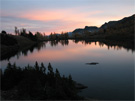
 Glacier snout 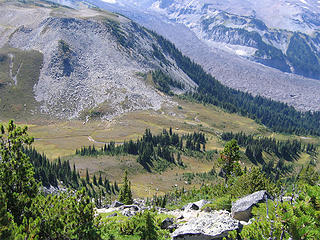 first basin from higher up ridge 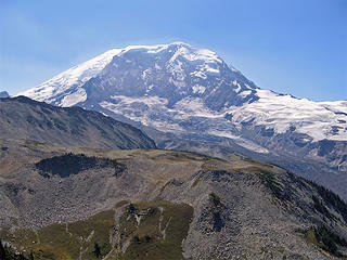 Mt Rainier 1 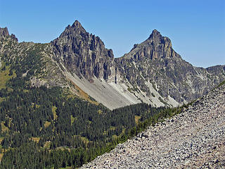 Sluiskin mountain 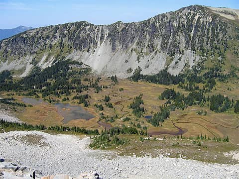 Elysian Field 2 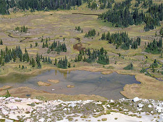 Elysian Field 7 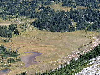 Elysian Field 6 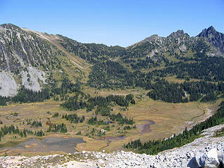 Elysian Field 8 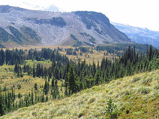 Elysian-Field 11 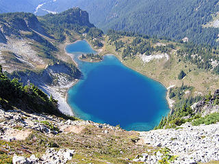 Crescent lake from Crescent mtn 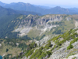 Yellowstone cliffs 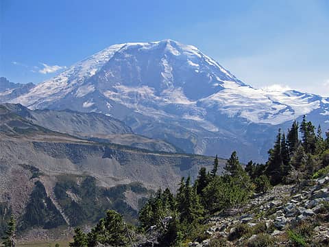 Mt Rainier 2 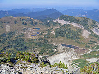 windy pass 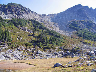 route from crescent mtn
|
| Back to top |
  
|
|
Dayhike Mike
Bad MFKer
Joined: 02 Mar 2003
Posts: 10955 | TRs | Pics
Location: Going to Tukwila |
Nice pics...thanks for the TR.
Looks like a fun loop hike...did you see many people once you got off the beaten path?
"There is only one basic human right, the right to do as you damn well please. And with it comes the only basic human duty, the duty to take the consequences." -P.J. O'Rourke
"Ignorance is natural. Stupidity takes commitment." -Solomon Short
"There is only one basic human right, the right to do as you damn well please. And with it comes the only basic human duty, the duty to take the consequences." -P.J. O'Rourke
"Ignorance is natural. Stupidity takes commitment." -Solomon Short
|
| Back to top |
|
|
Dean
(aka CascadeHiker)

Joined: 02 Mar 2002
Posts: 1967 | TRs | Pics
Location: ex Kennewick, Wa & Lehi Utah |
|
Dean
(aka CascadeHiker)
|
Sun Aug 28, 2005 11:22 am |
|
|
Super pics and TR. Crescent Lake is a beauty. 
|
| Back to top |
|
|
cheakamus
Member

Joined: 19 Jul 2003
Posts: 331 | TRs | Pics
Location: Seattle |
The name "Elysian Fields" is really very apt. My partner and I were there a month ago doing pretty much the same circuit you did (but summiting Old Desolate rather than Crescent Mt.) With all the ups and downs we figured we did about 6500' vertical that day. When we were there, the Fields were awash in blooming lupines. Their scent was almost overwhelming, and I was reminded of Dorothy and her companions crossing the poppy fields on their way to the Emerald City. I wondered at the time how many people ever come upon this place, distant as it is from any gazetted trail. We were pretty much following a one-sentence "suggestion" in our guidebook: head for Windy Gap and take the Northern Loop trail home. Our only difficulty came when we reached the saddle between Crescent and Sluiskin Mts.the obvious way down ended in a narrow vertical chasm and we were forced to backtrack. While contemplating returning the way we'd come (and adding another 1500' or so vertical and god knows how many more miles to our total) we noticed a goat track heading down the back side of Sluiskin, and we eventually ended up in a bowl on the wrong side of Windy Gap but thankfully back on trail again. A swim in the lake at Windy Gap, which was bathtub warm, even at 6 p.m., restored our energy for the long walk out. Oh, there was one other glitchwhen we came to the lower crossing of the Carbon, we weren't sure we could make it across. The water was raging under and over the log, and it seemed certain to be swept away at any moment. Faced with a three-mile detour via the upper, suspension bridge, however, we (probably foolishly) put our fears aside and scampered across. I wonder if the log is still there?
|
| Back to top |
|
|
Joe
Member
Joined: 29 Jun 2002
Posts: 819 | TRs | Pics
Location: Kent |
|
Joe
Member
|
Sun Aug 28, 2005 4:27 pm |
|
|
Since it was Friday, with a somewhat early start, 8:30 am, and a late finish, 7:20 PM, I didn't see very many people. Maybe a dozen all day, 4 on the way out from Windy Gap.
In the off trail section, I keep hearing sounds and maybe voices. Hiking solo, I thought it was just the wind or the constant rock fall on Willis Wall. Then just before I reached the Crescent Mountain ridge, I saw one person 500 feet below and quarter mile east heading up from Elysian Fields.
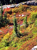
The flowers in Elysian field were past their prime. There were quite a few Mountain Bog Gentian in bloom. I would have liked to seen this place when the Lupine were at their peak.
While trying to find the easiest way down to windy gap, I also started down the chasm Cheakamus described. After a short exploration, I decided this was not the way to go and back tracked to a section just west of point 6506. This turned out to a fairly easy descent. I'm not sure why I didn't head down this route when I first encountered it. The exploration for a easier route cost me half hour in time and an extra 1/2 mile of hiking.
While I was descending toward the Carbon river, I realized I had not checked to see if the bridges were in place. As I got closer to the river, instead of the several channels I had seen in the past, there was just one river channel raging on the east side. Now I was really worried about the bridge. I wasn't looking forward to an extra two miles of hiking via the suspension bridge. The bridge was in, but leaning some and looking a little precarious with the water was just below the bridge.
My total mileage for the trip was 16.5+ and 5400 feet of elevation gain.
|
| Back to top |
|
|
ragman and rodman
Member

Joined: 28 Apr 2005
Posts: 1219 | TRs | Pics
Location: http://rgervin.com/ |
What an impressive looking place... a friend mentioned this one to me over 20 years ago and just raved about it... A couple of years ago I did Tyee Peak (the flat thing on top of the Yellow Cliffs) and really liked the area... over time Elysian Fields has been erased from my memory bank (along with many other things)... thanks for the report... I just broke out the "to do" list...
|
| Back to top |
|
|
silence
Member

Joined: 25 Apr 2005
Posts: 4420 | TRs | Pics
|
|
silence
Member
|
Mon Aug 29, 2005 7:42 pm |
|
|
Very cool TR. We hoped to do that this year - loving the area much - but put it on the backburner. Your report and pix have inspired us!
PHOTOS
FILMS
Keep a good head and always carry a light bulb. Bob Dylan
PHOTOS
FILMS
Keep a good head and always carry a light bulb. Bob Dylan
|
| Back to top |
|
|
Malachai Constant
Member

Joined: 13 Jan 2002
Posts: 16100 | TRs | Pics
Location: Back Again Like A Bad Penny |
I have been going there for several years but have refrained from posting TR please STFU. 
"You do not laugh when you look at the mountains, or when you look at the sea." Lafcadio Hearn
"You do not laugh when you look at the mountains, or when you look at the sea." Lafcadio Hearn
|
| Back to top |
|
|
sarbar
Living The Dream
Joined: 28 Jan 2002
Posts: 8055 | TRs | Pics
Location: Freeland, Wa |
|
sarbar
Living The Dream
|
Tue Aug 30, 2005 5:29 pm |
|
|
If there is one thing I have learned from doing X/C trips at Rainier is this: Just cause someone posts info (ie..a TR) it doesn't mean people are going to flock to it..some will, but dang, X/C is NOT easy, and most people are too lazy. That and getting a X/C backpacking permit via MRNP isn't easy cheezy.
Let's not start the "Forbidden Trail" junk again.....unless you are posting a highly detailed GPS report..so what?
I'd post my X/C trip from last weekend, but I promised my friend Hikingdrew I wouldn't except for photos (and yeah, they are on Trail Talk)-but if anyone were to ask me, sure I'd share the info.
BTW, nice TR 
|
| Back to top |
|
|
Slugman
Its a Slugfest!

Joined: 27 Mar 2003
Posts: 16874 | TRs | Pics
|
|
Slugman
Its a Slugfest!
|
Tue Aug 30, 2005 6:11 pm |
|
|
Fabulous pics, but due to the difficulty of the hike I won't be swarming over the area any time soon. Thanks for allowing a little "virtual hiking" to the less-abled on the site.
|
| Back to top |
|
|
cheakamus
Member
Joined: 19 Jul 2003
Posts: 331 | TRs | Pics
Location: Seattle |
Perhaps someone could just post a list of all the fabulous places we're not supposed to mention so everyone can be on the same page here. Alternatively, if you see a place you really really like, don't dare write about itsomeone's sure to slap you down!
If you want to know where you can write about, why not pick one from the "Most disappointing hikes" list elsewhere on this board?
Alternatively, if you see a place you really really like, don't dare write about itsomeone's sure to slap you down!
If you want to know where you can write about, why not pick one from the "Most disappointing hikes" list elsewhere on this board?
|
| Back to top |
|
|
Snowshoe Hare
Defunct lagomorph

Joined: 03 Dec 2004
Posts: 1185 | TRs | Pics
|
I honestly would like to know if I was wrong in thinking that in national parks and MRNP more specifically- you're supposed to "stay on the trail, stay on the trail" but this hike was off trail for some of it. Above a certain altitude (8000'?) at MRNP you need a climbing permit, but can you get a permit for off-trail travel? Is this what Sarbar was talking about with a special XC backpacking permit? At any rate I'd never heard of Elysian Fields before except in Greek or Roman mythology I think it was. Very cool country and nice photos and report.
|
| Back to top |
|
|
Slugman
Its a Slugfest!
Joined: 27 Mar 2003
Posts: 16874 | TRs | Pics
|
|
Slugman
Its a Slugfest!
|
Tue Aug 30, 2005 9:35 pm |
|
|
I think (but I'm not sure) that "stay on the trail" means don't cut switchbacks or trample areas near the trail. I don't think it means no off-trail travel to places that don't have a trail. They are trying to keep places like Spray park from getting trampled, not keep anybody from ever going to Elysian fields. Does anybody FOR SURE what the deal is on this?
|
| Back to top |
|
|
sarbar
Living The Dream
Joined: 28 Jan 2002
Posts: 8055 | TRs | Pics
Location: Freeland, Wa |
|
sarbar
Living The Dream
|
Tue Aug 30, 2005 9:36 pm |
|
|
|
| Back to top |
|
|
gary
Member
Joined: 07 Sep 2003
Posts: 367 | TRs | Pics
Location: west of Denver |
|
gary
Member
|
Tue Aug 30, 2005 9:44 pm |
|
|
|
| Back to top |
|
|
|
|


 The point up there is that yes, you can go off trail, but to pick your path wisely