| Previous :: Next Topic |
| Author |
Message |
whitebark
Member


Joined: 08 Jul 2005
Posts: 1864 | TRs | Pics
Location: Seattle |
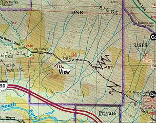
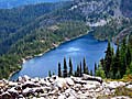
These are two of the finest trails close to Seattle that you won't find in maps or guidebooks. The snow melts early on this south facing slope, perfect for those who want to hike some snow-free trails with high mountain scenery, yet are tired of Tiger Mountain. Only a few small patches of snow remain now.
To get to Dirty Harry's Connector (my name), park at the Mason Lake/Ira Spring Trailhead. Try to ignore the piles of broken window glass on the parking lot as you park your expensive SUV, then set out up the trail to the first switchback of the old road/trail, less than one quarter mile from the trailhead. The unsigned but obvious Dirty Harry's connector trail lakes off west from the switchback, elev. 2300'.
First Mystery: who has been working on this trail? I expected a narrow boot trail, but found a wide, constructed tread. The trail dips down a ravine, than crosses a recent debris flow/avalache that has wiped out a few feet of the trail. Good view of McClellan Butte from here. The trail then heads into a viewless forest and soon reaches another surprising spot, a junction with a well-built old trail coming up the slope. This trail I will call the Defiance Ridge Trail.
Second Mystery: who built this old but amazingly good trail (almost National Park Quality) and why? My guess is that perhaps the Forest Service was planning to place a lookout up on the ridge, and that this trail was built for access.
I took the uphill branch of this trail (one source I talked to said that the trail descends all the way to the bottom of the Snoqualmie valley, meeting an ignimonious end near the shoulder of I-90). Beyond the trail junction, the trail begins a steady, well-graded climb up the slope, making one long switchback. Somebody has been maintaining the trail and there is little blowdown to contend with. There are no views, but the forest is pretty and there are mossy boulders to look at.
After a long mile from the Mason Lake trailhead, this trail levels off a bit (passing a simply huge trunk of a dead douglas fir ) and dips into a ravine. Next to a mossy cliff a second, slightly obscure junction is reached, elev. 2800'. The lower trail branch is Dirty Harry's Connector (my name), which leads to his namesake Balcony. The upper branch is the continuation of the Defiance Ridge Trail.
I first chose to follow Dirty Harry's Connector (DHC) trail. This trail is much rougher than than the Defiance Ridge Trail, frequently dipping through gullies with rushing snowmelt streams. Despite following a rough contour at 2700 to 2800' this trail is tiring due to the many ups and downs. In less than a half mile, the trail smooths out and arrives at a surprising flat area thickly forested with hemlock, that might be a good spot to camp. At an obscure junction, a short side trail heads out onto a rocky bluff (elev. 2720')with a fantastic view west toward DH's balcony and Mt Washington. This is a great spot, don't miss it.
The DHC trail continues on from the junction, crossing a talus field (another great vista of McClellan Butte here) then rapidly losing about 200 feet as it make tricky crossings of two stream gullies. Gentler terrain is reached when the trail connects with an old logging road, which soon takes you to the Dirty Harry's Balcony trail.
I had been to DHB many times, so I turned back here and returned the way I came. With some energy remaining, I decide to explore the Defiance Ridge Trail. Its carefully crafted switchbacks climbed the steep slope at an even grade. Suddenly at 3150', the fun ended. I could see the exact spot where the mystery trail builders simply gave up. A poorer quality trail continued on and I followed it up the hill until I ran into snow at about 3300'.
Mystery #3: Why did they quit building the trail after putting in so much work?
I had been up this way once before some years ago, and recalled that the way trail above here steadily deteriorates until you are heading straight up the fall line. I climbed all the way to point 5100 on what is sometimes called "Banana Ridge". From there, I traversed east on the ridge , eventually reaching the Mt Defiance Trail. I looped back to the car via Mason Lake. A fun, strenous hike when the snow melts.
 map
|
| Back to top |
  
|
|
Malachai Constant
Member

Joined: 13 Jan 2002
Posts: 16100 | TRs | Pics
Location: Back Again Like A Bad Penny |
In addition to this there is a quite good trail that takes off from the Dirty Harrys Peak Road spur that you get to below the talus field. It passes Upper Granite Lake and eventually connects to Banana Ridge and Putrid Petes Peak. It gets sketchy at times but is blazed. It would be possible to make a big loop here. It is also possible to traverse all the way from Bandera to Mailbox staying on the ridge most of the time (the worst spot is the west end of Dirty harrys peak)
"You do not laugh when you look at the mountains, or when you look at the sea." Lafcadio Hearn
"You do not laugh when you look at the mountains, or when you look at the sea." Lafcadio Hearn
|
| Back to top |
|
|
Dayhike Mike
Bad MFKer
Joined: 02 Mar 2003
Posts: 10955 | TRs | Pics
Location: Going to Tukwila |
Great post, Whitebark! Thanks for the TR.
I've noticed what appeared to be a trail coming out of the forest next to I-90 in that section, but always assumed I was just imagining it. I'm often looking for old trails and side paths as I'm tromping down the main path toward my destination.
"There is only one basic human right, the right to do as you damn well please. And with it comes the only basic human duty, the duty to take the consequences." -P.J. O'Rourke
"Ignorance is natural. Stupidity takes commitment." -Solomon Short
"There is only one basic human right, the right to do as you damn well please. And with it comes the only basic human duty, the duty to take the consequences." -P.J. O'Rourke
"Ignorance is natural. Stupidity takes commitment." -Solomon Short
|
| Back to top |
|
|
rodman
Member
Joined: 03 May 2005
Posts: 49 | TRs | Pics
|
|
rodman
Member
|
 Thu Apr 06, 2006 5:53 pm |
|
|
Hi Whitebark,
That was an excellent report and it brought back memories of hikes I did in that area several years ago.
Attached is a copy of my GPS hiking routes in that vicinity, however, I have not completed the "missing 0.77 mile link".
After reading your report I will have to put it back on my (and Ragmans) to-do list!
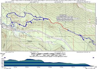 "Missing link between Dirty Harry's Balcony trail and the Mason Lake trail"
|
| Back to top |
|
|
|
|
You cannot post new topics in this forum
You cannot reply to topics in this forum
You cannot edit your posts in this forum
You cannot delete your posts in this forum
You cannot vote in polls in this forum
|
Disclosure: As an Amazon Associate NWHikers.net earns from qualifying purchases when you use our link(s). |


