| Previous :: Next Topic |
| Author |
Message |
sarbar
Living The Dream


Joined: 28 Jan 2002
Posts: 8055 | TRs | Pics
Location: Freeland, Wa |
|
sarbar
Living The Dream
|
 Wed Jul 12, 2006 8:10 pm |
|
|
Hoosierdaddy, Mtnwkr, Ford and me did an overnighter, doing a combo of road walking, abandonded trail and X/C hiking.
Obstruction Point rd is open to Waterhole currently-they are hoping to open this weekend-if the road firms up. The road is cleared of all snow though.
As usual, it was very wind and cold on most of the hike.
We got rain about 2/3 rds of the way in. Snow wise we encountered very little. The flowers were on the down side in most areas, though lupine was starting to pop, and avy lilies were plenty still. Deer and marmots were plentiful..we had a lone duck give us company on the lake.
Hiked out in wind and rain this morning-but still a gorgeous trip.
|
| Back to top |
  
|
|
l
Member

Joined: 24 Nov 2005
Posts: 1030 | TRs | Pics
|
|
l
Member
|
Wed Jul 12, 2006 8:26 pm |
|
|
It's a shame the weather wasn't better because, as you say, the views are great. That's the second time you've been cursed with bad conditons in the Olympics this year (I think Geyser Valley was the other; at least no car damage this time  ).
Did you camp at Obstruction Lake, aka Pumpkinseed Lake? And how were the avalanche lilies about 1/4 mile before the Obstruction Point parking lot? ).
Did you camp at Obstruction Lake, aka Pumpkinseed Lake? And how were the avalanche lilies about 1/4 mile before the Obstruction Point parking lot?
|
| Back to top |
|
|
sarbar
Living The Dream
Joined: 28 Jan 2002
Posts: 8055 | TRs | Pics
Location: Freeland, Wa |
|
sarbar
Living The Dream
|
Wed Jul 12, 2006 8:39 pm |
|
|
|
| Back to top |
|
|
l
Member
Joined: 24 Nov 2005
Posts: 1030 | TRs | Pics
|
|
l
Member
|
Wed Jul 12, 2006 9:14 pm |
|
|
Weird news about the privies - they just replaced them last year!
The tarn is also called Draper Lake, for the rock found about 40 yards upstream from the inlet (pictured below). I also included a shot from the plateau above the little lake.
Thanks for your help.
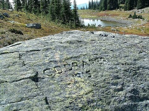 draper rock 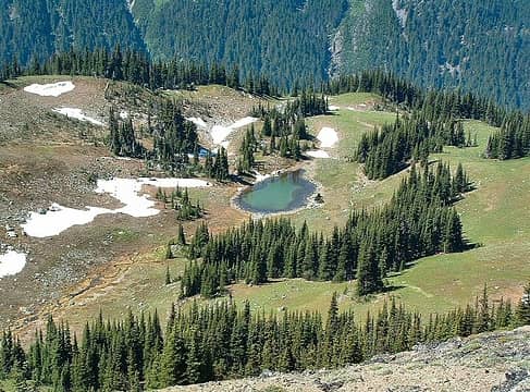 pumpkinseed
|
| Back to top |
|
|
sarbar
Living The Dream
Joined: 28 Jan 2002
Posts: 8055 | TRs | Pics
Location: Freeland, Wa |
|
sarbar
Living The Dream
|
Wed Jul 12, 2006 9:36 pm |
|
|
Wow! Those photos are so neat!
Not sure how I missed the rock..dang! We were intriqued by this:
It was a neat place to eat.
And:
Now, do you knwo any of the history behind the area, and the garbage dumps out there? I know my Calmute baking powder containers..and the one we found in the first hole, well, it was at least 50 years old, if not older.
It was a very intresting area. Wondering how the guys missed that rock-they went exploring all over the ridges.
|
| Back to top |
|
|
l
Member
Joined: 24 Nov 2005
Posts: 1030 | TRs | Pics
|
|
l
Member
|
Wed Jul 12, 2006 9:55 pm |
|
|
Sarbar, many moons ago Obstruction Lake was a prime camping area. Technically, you're not supposed to camp there now because it's less than a mile from the trailhead. But as you probably know, there's not much water up there after mid summer and Pumpinseed is one reliable source. The site is also somewhat protected and has wood for fires. Back during the forest service and early Park days, when trail building was underway (including a failed attempt to continue the road past Obstruction Peak), crews brought camping stuff down to the lake. There used to be more rusted stoves, pots, etc. but the Park removed most of it.
If interested, I can point an arrow to Draper Rock in the photo.
|
| Back to top |
|
|
sarbar
Living The Dream
Joined: 28 Jan 2002
Posts: 8055 | TRs | Pics
Location: Freeland, Wa |
|
sarbar
Living The Dream
|
Wed Jul 12, 2006 10:06 pm |
|
|
I spotted the rock in the photo..had I had my boots on when exploring I would have come across it (but I had my rainbow crocs on...they tread lightly, but let water in).
We did find a very old elaborate fire pit. I have gotten so used to no fires at Rainier, that the thought of a fire in high country seems, well, odd.
We had a X/C permit and since the road was closed, we were technically ok  I wouldn't do the trip once the road is open, but it was indeed a great trip. In the Olympics, the Obstruction area is my favorite. I have always wanted to spend a night at Roaring Winds Pass....that or in the meadows of Badger Valley.
I can dream I wouldn't do the trip once the road is open, but it was indeed a great trip. In the Olympics, the Obstruction area is my favorite. I have always wanted to spend a night at Roaring Winds Pass....that or in the meadows of Badger Valley.
I can dream
|
| Back to top |
|
|
Phil
Member

Joined: 02 Jul 2003
Posts: 2025 | TRs | Pics
Location: Shoreline, WA |
|
Phil
Member
|
Thu Jul 13, 2006 11:18 am |
|
|
| Shacknasty Jim wrote: | | ......Back during the forest service and early Park days, when trail building was underway (including a failed attempt to continue the road past Obstruction Peak.... |
Do you happen to know why it failed? I heard a claim it was because of monkeywrenching but I dunno.
|
| Back to top |
|
|
l
Member
Joined: 24 Nov 2005
Posts: 1030 | TRs | Pics
|
|
l
Member
|
Thu Jul 13, 2006 2:49 pm |
|
|
From what I've read, the reasons were twofold. Like many other civil projects, work was halted when WWII broke out. The other is simple physics. The basin formed by Obstruction Peak and the ridge connecting it to Elk Mountain is steep and unstable.
|
| Back to top |
|
|
sarbar
Living The Dream
Joined: 28 Jan 2002
Posts: 8055 | TRs | Pics
Location: Freeland, Wa |
|
sarbar
Living The Dream
|
Thu Jul 13, 2006 3:15 pm |
|
|
I have always wondered how hard that would have been to maintain across Elk Peak. The road bed is very visible on both sides (refering to Deer Park). Though I must say, no matter what the reasons, when walking the trail to Deer Park, it is indeed a blessing it isn't there!
And yes, those slopes are indeed very unstable.
|
| Back to top |
|
|
Phil
Member
Joined: 02 Jul 2003
Posts: 2025 | TRs | Pics
Location: Shoreline, WA |
|
Phil
Member
|
Thu Jul 13, 2006 3:57 pm |
|
|
| Shacknasty Jim wrote: | | From what I've read, the reasons were twofold. Like many other civil projects, work was halted when WWII broke out. The other is simple physics. The basin formed by Obstruction Peak and the ridge connecting it to Elk Mountain is steep and unstable. |
Well darn. Until now I've been holding dear to the more entertaining but less realistic explanation that radical activists were pulling up surveying stakes and otherwise sabotaging the effort.
|
| Back to top |
|
|
l
Member
Joined: 24 Nov 2005
Posts: 1030 | TRs | Pics
|
|
l
Member
|
Thu Jul 13, 2006 4:06 pm |
|
|
| Phil wrote: | | Shacknasty Jim wrote: | | From what I've read, the reasons were twofold. Like many other civil projects, work was halted when WWII broke out. The other is simple physics. The basin formed by Obstruction Peak and the ridge connecting it to Elk Mountain is steep and unstable. |
Well darn. Until now I've been holding dear to the more entertaining but less realistic explanation that radical activists were pulling up surveying stakes and otherwise sabotaging the effort. |
I don't think the monkey-wrench types were operating back then.
I'm always amazed at some of the abandoned plans of Olympic's past. At one time a road was seriously considered to be built up the Elwha, over Low Divide and down the Quinault. A ski resort was considered for Soleduck Park (Heart Lake), a dam for Goblin Gates, a tramway at Soleduck Hot Springs, reopening Tubal Cain to mining and a trail built along the Bailey Range!
|
| Back to top |
|
|
sarbar
Living The Dream
Joined: 28 Jan 2002
Posts: 8055 | TRs | Pics
Location: Freeland, Wa |
|
sarbar
Living The Dream
|
Thu Jul 13, 2006 4:22 pm |
|
|
Wasn't it Wood's book that had a bunch of the history in it? Intresting to read!
|
| Back to top |
|
|
Phil
Member
Joined: 02 Jul 2003
Posts: 2025 | TRs | Pics
Location: Shoreline, WA |
|
Phil
Member
|
Thu Jul 13, 2006 5:37 pm |
|
|
| Shacknasty Jim wrote: | | I'm always amazed at some of the abandoned plans of Olympic's past. At one time a road was seriously considered to be built up the Elwha, over Low Divide and down the Quinault. A ski resort was considered for Soleduck Park (Heart Lake), a dam for Goblin Gates, a tramway at Soleduck Hot Springs, reopening Tubal Cain to mining and a trail built along the Bailey Range! |
Yep, dodged those bullets. And what about the stuff that came and went. Enchanted valley resort/chalet. Flapjack lakes ski hut/chalet. Of course the homesteads.
|
| Back to top |
|
|
wildernessed
viewbagger

Joined: 31 Oct 2004
Posts: 9275 | TRs | Pics
Location: Wenatchee |
The "BomB", The Olympics from Lillian Ridge, one of the finest views in America. Hannah and I backpacked a loop out around Moose Lake on a road trip when we lived back in Ohio. I have a pic of the range from that ridge and it's one of my favorites. Nice crapper with a view near Moose Lake. 
Living in the Anthropocene
Living in the Anthropocene
|
| Back to top |
|
|
|
|


 Jerkwad NParkies


