| Previous :: Next Topic |
| Author |
Message |
GeoHiker
Rocky Walker


Joined: 26 Feb 2005
Posts: 6033 | TRs | Pics
Location: Off the Deep End |
|
GeoHiker
Rocky Walker
|
 Fri Mar 02, 2007 3:53 pm |
|
|
With all the new snow and sunshine yesterday I had to get out some where. Power had been off most of the night and I woke up to a winter wonderland with 10 inches of new snow. I figured the roads would be a mess, but not too bad in the sunny areas. Once down to Monroe they were slushy, but clear on US 2.
I didn't have a destination in mind as I knew any side roads would be tough without chains or 4x4. Once past Goldbar the snow deepened to at least 12 inches of new. Where to go, where to go. Ok, Heybrook LO would be awesome in the new snow and the large patches of blue sky was looking better and better. As I slowed down for the parking area I could see there was no way I could bust through the 2 ft. of plowed snow on the side of the road.
Bag that idea. Farther up the road past Baring I thought I might give Barclay Lk a try. Pull off US 2 and no way the road was a disaster of deep snow and ruts. Barely got turned around without having to pull out the shovel and chains. Maybe Beckler Rd was plowed and I could head that way. Nope it was a rutted mess too.
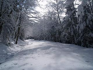
Maybe I'll head all the way to the ski area and do Skyline. It was looking cloudy and dark in that direction, so I hated to leave the blue sky and sun. One more shot as I passed Skykomish. I turned off on the Foss River Rd. FS 68 and it was plowed!.....Hmmm, wonder how far. Once past the homes it kept on going, so cool. Past the trestle and there's a road grader plowing out the parking area. What great timing! I gave the driver a thumbs up as he finished up and headed back down the road and all was quiet.
The 12 inches of new was shiny in the bright sun. I grabbed my snowshoes thinking any second a bus load of people would come pulling in or worse one of those skinny skiers to muck up the untracked snow..... The snow was starting to bomb off the trees, so I had to keep an eye out above. I really didn't need snowshoes as the underneath base was rock hard, but it was nice not struggling in the deep fluff.
The road follows above and alongside the Foss River, so the cascading water and new snow made for a chorus of sound. Several warning saw horses and downed trees mark the recent storm damage. I hung a left when I reached the junction of FS 6830 that heads up to Tonga Ridge. I was thinking I'd climb up a couple miles and find a lunch spot and take in the views. Clouds and some light snow started to fall and where did my blue sky go?.....I could see it was still blue back down the valley, so my ambition wasn't running high as I climbed higher. Everything was clouded in towards Malachite.
About the 1 mile marker are some concrete barriers and a large road closed sign. I could see where the creek overflowed the road, but the damage looked to be minimal. Snow here was only the new. (2,000 ft) This area gets good southern exposure, so it must have melted out with the long warm spell we had. I continued on for another 1/4 mile and made that my turn around. The clouds and dark skies were not looking favorable.
4 miles and about 1,000 ft. gain. so that was enough in the new fluff. Back to my car and the sun was shinning brightly and it was clear to the north. Maybe I can get up the Beckler now. Nope it's still snowed in. Maybe the Miller. No it's way too deep without 4x4. As I poked back down US 2 I turned off on to Index Creek Rd. I've never been on this road. It was plowed, so crossing the river on the old bridge was easy. What a cool old single lane bridge!
On the other side I pulled off and walked out on the bridge with my camera. I snapped a few pics of Baring Mt and walked across the snow covered center. I felt a sickening sinking feeling and must have jumped 3 ft. The bridge has a wire mess center! As I walked back to my car I noticed several spots where the mess was broken and open to the river below.
I headed back west and tried to get up the Mt. Index rd, but that hadn't been plowed yet, so I turned around at the turn off to the Lk Serene parking lot. There was one car parked on the side of the road. Back out to 2 it's a short distance to the Forks of the Sky state park. This is the site of a former private campground and is being held for a future use. There's a nice trail that drops about 1/4 mile to the river and several overlook spots on the river. The 12 inches of new was untracked, so I snapped a few pics and headed on home. What a gorgeous day to play in the snow. Here are a few pics. The snow was starting to bomb off the trees, so I had to keep an eye out above. I really didn't need snowshoes as the underneath base was rock hard, but it was nice not struggling in the deep fluff.
The road follows above and alongside the Foss River, so the cascading water and new snow made for a chorus of sound. Several warning saw horses and downed trees mark the recent storm damage. I hung a left when I reached the junction of FS 6830 that heads up to Tonga Ridge. I was thinking I'd climb up a couple miles and find a lunch spot and take in the views. Clouds and some light snow started to fall and where did my blue sky go?.....I could see it was still blue back down the valley, so my ambition wasn't running high as I climbed higher. Everything was clouded in towards Malachite.
About the 1 mile marker are some concrete barriers and a large road closed sign. I could see where the creek overflowed the road, but the damage looked to be minimal. Snow here was only the new. (2,000 ft) This area gets good southern exposure, so it must have melted out with the long warm spell we had. I continued on for another 1/4 mile and made that my turn around. The clouds and dark skies were not looking favorable.
4 miles and about 1,000 ft. gain. so that was enough in the new fluff. Back to my car and the sun was shinning brightly and it was clear to the north. Maybe I can get up the Beckler now. Nope it's still snowed in. Maybe the Miller. No it's way too deep without 4x4. As I poked back down US 2 I turned off on to Index Creek Rd. I've never been on this road. It was plowed, so crossing the river on the old bridge was easy. What a cool old single lane bridge!
On the other side I pulled off and walked out on the bridge with my camera. I snapped a few pics of Baring Mt and walked across the snow covered center. I felt a sickening sinking feeling and must have jumped 3 ft. The bridge has a wire mess center! As I walked back to my car I noticed several spots where the mess was broken and open to the river below.
I headed back west and tried to get up the Mt. Index rd, but that hadn't been plowed yet, so I turned around at the turn off to the Lk Serene parking lot. There was one car parked on the side of the road. Back out to 2 it's a short distance to the Forks of the Sky state park. This is the site of a former private campground and is being held for a future use. There's a nice trail that drops about 1/4 mile to the river and several overlook spots on the river. The 12 inches of new was untracked, so I snapped a few pics and headed on home. What a gorgeous day to play in the snow. Here are a few pics.
 Starting up the road. 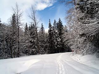 Looking back down the road. 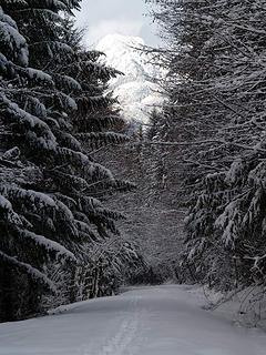 About mile post 1. 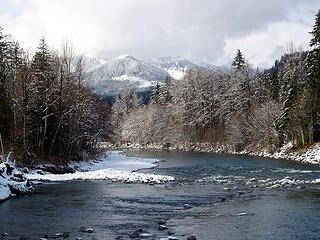 Skykomish River near Baring 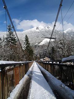 Old Single Lane Bridge on the Sky. 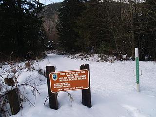 New State park near Index 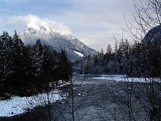 Baring Mt near Index 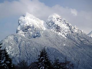 Close up of Baring Mt
You call some place paradise, kiss it goodbye......Eagles
You call some place paradise, kiss it goodbye......Eagles
|
| Back to top |
  
|
|
Sabahsboy
Member

Joined: 18 Jul 2006
Posts: 2484 | TRs | Pics
Location: SW Sno County |
|
Sabahsboy
Member
|
Fri Mar 02, 2007 7:30 pm Tonga road
|
|
|
What is your evalutation for repairs on this road? Seems I read that the damage was low on the road and you may have walked beyond that washout.
Photos look enticing. Of course, it is raining, now! Great shots of Baring!
|
| Back to top |
|
|
GeoHiker
Rocky Walker
Joined: 26 Feb 2005
Posts: 6033 | TRs | Pics
Location: Off the Deep End |
|
GeoHiker
Rocky Walker
|
Fri Mar 02, 2007 7:46 pm |
|
|
I think I did cross the washed out area. From what I could tell the creek overflowed the road and ran down about 100 ft. There were concrete barriers placed about every 30 ft. to divert the water back into the ditch. It didn't look like any of the road washed out and it would be an easy fix. The road was snow covered, but there wasn't any ruts or deep washed areas that I could see.
People have been driving the road above where I turned around. When I was up there about a month ago the road was solid ice so you could easily drive on top of the frozen snow. Someone had driven to the Trout Lake turnoff. I could see where 4x4's pulled off and sank into the snow. There were some deep wheel ruts in spots.
There are some trees down across the road, but nothing that couldn't be easily removed with a chain saw. Snocats have been going up to the Maloney Ridge communication site, so that road stays packed down most of the winter.
You call some place paradise, kiss it goodbye......Eagles
You call some place paradise, kiss it goodbye......Eagles
|
| Back to top |
|
|
Sabahsboy
Member
Joined: 18 Jul 2006
Posts: 2484 | TRs | Pics
Location: SW Sno County |
|
Sabahsboy
Member
|
Fri Mar 02, 2007 8:42 pm Tonga Ridge access
|
|
|
Thank you, GeoHiker! Sounds like smart strategy by Forest Service or some agency to salvage the road. This is a popular place in the summer and deserves to be open for the families that hike the ridge trail.
I have never driven beyond the cut-off to Tonga trail and almost did so last autumn....I'd hate to say I so narrowly missed the opportunity. The road ends, per the maps, and has access to trails to Tonga from the east and Deception Creek Tr. and to Fisher Lake. The latter is a place I'd like to go...see the road and views over Skykomish and up Beckler plus the adventure to Fisher Lk.
Probably had not been on Tonga access road for decades but for a x-c ski trip in late '80's. Friends decided on Foss River road for skiing and I took the "high road". Gosh...there are so many places to visit, summers and winters.
|
| Back to top |
|
|
GeoHiker
Rocky Walker

Joined: 26 Feb 2005
Posts: 6033 | TRs | Pics
Location: Off the Deep End |
|
GeoHiker
Rocky Walker
|
Fri Mar 02, 2007 8:59 pm |
|
|
That's a nice area to explore. The road that goes east isn't travelled like years past, so there are some excellent side roads that lead to great camping spots. Many of those roads are up for closure, so I hope they leave that area alone. So few logging areas that are still open for travel anywhere along US 2.
You can access Deception Creek and above, but it's a climb, so I don't think you save much by going in that way. The regular trail starts at 4400 ft. and is a great hike past Mt. Sawyer with some awesome views and berry fields.
You call some place paradise, kiss it goodbye......Eagles
You call some place paradise, kiss it goodbye......Eagles
|
| Back to top |
|
|
Sabahsboy
Member
Joined: 18 Jul 2006
Posts: 2484 | TRs | Pics
Location: SW Sno County |
|
Sabahsboy
Member
|
Mon Mar 05, 2007 7:57 pm Tonga and Mt. Sawyer
|
|
|
Yes...I know well how nice Tonga Ridge is. I was looking over the Green Trails map last night and decided that the hike from the usual TH is just as valid and though a bit longer, saves the difficult and long road access to the terminous above Deception Creek. Fisher Lake still looks inviting...and a chance to see Terrace Mountain up close. Several folks wrote of Fisher Lake last summer...as I recall, there was some confusion about the trail (splitting and dead ending and some steep or scramble spots). We were at Mt. Sawyer summit late season, 2005 and again for the flowers in 2006. Maybe not Paradise Meadows, but pretty nice!
|
| Back to top |
|
|
Quark
Niece of Alvy Moore

Joined: 15 May 2003
Posts: 14152 | TRs | Pics
|
|
Quark
Niece of Alvy Moore
|
Mon Mar 05, 2007 8:40 pm |
|
|
I think I'm the only loser in Washington that hasn't been to Tonga Ridge area.
"Skykomish River near Baring" is a beauiful photo. I love the faint rose color of the trees, and you can even seem them reflected in the wide, slow-moving part of the River.
That's cool about the new State Park, too. 
"...Other than that, the post was more or less accurate."
Bernardo, NW Hikers' Bureau Chief of Reporting
"...Other than that, the post was more or less accurate."
Bernardo, NW Hikers' Bureau Chief of Reporting
|
| Back to top |
|
|
Sabahsboy
Member
Joined: 18 Jul 2006
Posts: 2484 | TRs | Pics
Location: SW Sno County |
|
Sabahsboy
Member
|
Mon Mar 05, 2007 9:13 pm Tonga conga
|
|
|
Aw, Quark, you'll make it there! Great view from Sawyer...of Daniel and Hinman. Very nice view to north and Glacier. So, do go on a clear day or it would not be worth the visit. Autumn colors are pretty good.
|
| Back to top |
|
|
|
|
You cannot post new topics in this forum
You cannot reply to topics in this forum
You cannot edit your posts in this forum
You cannot delete your posts in this forum
You cannot vote in polls in this forum
|
Disclosure: As an Amazon Associate NWHikers.net earns from qualifying purchases when you use our link(s). |


