| Previous :: Next Topic |
| Author |
Message |
Yana
Hater


Joined: 04 Jun 2004
Posts: 4212 | TRs | Pics
Location: Out Hating |
|
Yana
Hater
|
 Sun Sep 16, 2007 8:23 pm |
|
|
Cast of Characters: Dicey, Amy, Jeanine (sp?), and moi.
We drove to the trailhead on Friday evening with the hope of car camping and getting an early start in the morning. Things began ominously when we missed the turnoff off Mosquito Lake Road, but we back tracked and quickly rectified the situation, finding FR 38 in short order but not without some confusion.
Expecting a quiet evening, we were surprised by the arrival of a large group of campers armed with various coolers and other fun items. Luckily, they chose to camp across the river, which drowned out any noise they may have been making.
We retired early to our various chosen sleeping locales. I decided to try sleeping in my car, which turned out surprisingly restful. Dicey had not had much fun in her bivy sack outside, where she had been molested by a mouse for most of the early morning hours. Initial investigation revealed that the dastardly creature had somehow snuck into her pack (serving as a pillow at the time), chewed through her food bag and found some yummy trail mix. However, it was later discovered that it had also chewed a prodigious hole in her bivy sack as well.
We set out on the gated road on our bikes, where I felt a bit daunted by the fact that everyone else had spiffy and useful mountain bikes, whereas I had a cheap, rusty piece of junk. Then, just to prove some sort of point, the chain on my bike fell off about 300 yards up the road. Later, my bike refused to switch to the lowest gear without some help from Amy. While this might sound bad, I actually decided to just walk up and push the bike for most of the way. It was much more efficient for me and not much slower than riding given the steepness of the grade.
After about 2.5 miles, there is an intersection where the route stays right - the various descriptions dicey and I had suggested an overgrown, brushy road, but this has been recently cleared and is now a very large gravel road replete with large earth moving machinery. The grade lets up here, and we were able to bike most of the next 2.5 miles to the final turn off - this road is actually brushy (as advertised) and much narrower, but still in good shape. The road makes a switchbacking ascent, where I just put my head down and didn't stop until it finally dead ended at a clearcut. Ostensibly, there is a perfect view of the west ridge of North Twin Sister from here - our chosen route. However, all we could see were low clouds. Oh well. At least the trail to the ridge was easy to find.
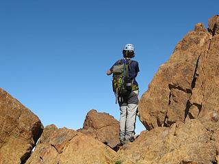
Due to a bizarre series of events, we misplaced Jeanine for about an hour on this stretch, but finally all of us gathered at the "trailhead," stashed our bikes, and trudged up through blueberries to the ridge. Initially, the ridge is timbered, but soon opens up and becomes rocky and the scrambling fun begins. And is it ever fun! The rock is solid, very grippy, and has super jugs at every turn.
Amazingly enough, around 5200' we found ourselves surrounded by blue skies, having left the low clouds below us.
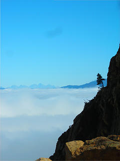 Morning on North Twin Sister 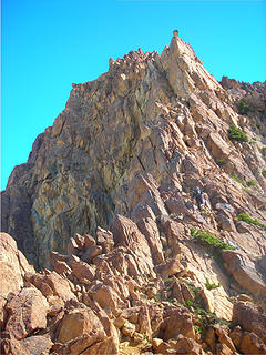 Amy on Ridge 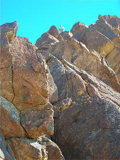 Jeanine on ridge 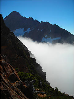 South Twin Sister and Fog 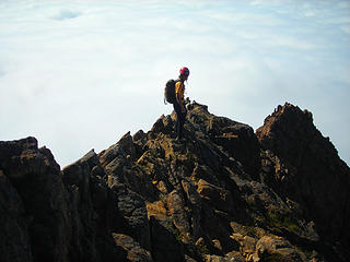 Carla on the gable 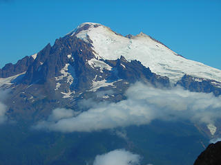 Baker 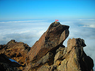 Blame Canada! 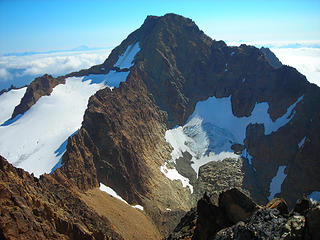 South Twin Sister 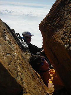 Carla and Amy on the Summit 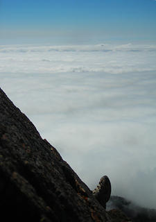 Summit Foot Shot 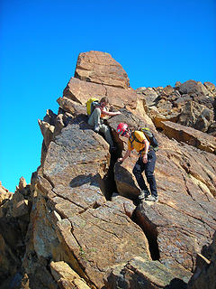 Descending the summit 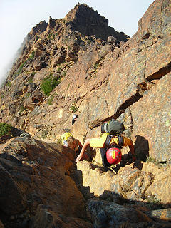 Descent Gully Fun 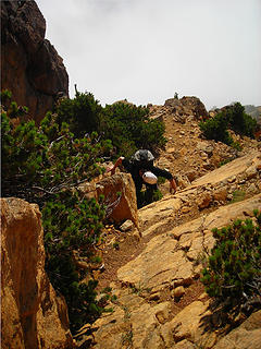 Amy on Descent 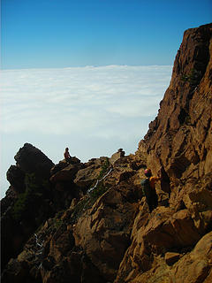 Descent 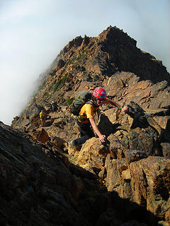 Carla Descending 
PLAY SAFE! SKI ONLY IN CLOCKWISE DIRECTION! LET'S ALL HAVE FUN TOGETHER!
PLAY SAFE! SKI ONLY IN CLOCKWISE DIRECTION! LET'S ALL HAVE FUN TOGETHER!
|
| Back to top |
  
|
|
Tazz
Member

Joined: 27 Apr 2005
Posts: 7902 | TRs | Pics
|
|
Tazz
Member
|
Sun Sep 16, 2007 8:35 pm |
|
|
|
| Back to top |
|
|
Magellan
Brutally Handsome

Joined: 26 Jul 2006
Posts: 13116 | TRs | Pics
Location: Inexorable descent |
|
Magellan
Brutally Handsome
|
Sun Sep 16, 2007 9:19 pm |
|
|
Great TR Yana. Another one bites the dust. Was Dicey the only one with a brain bucket? Did any rocks cut loose? How many feet worth of scrambling is there? Way to get after it.
|
| Back to top |
|
|
Yana
Hater
Joined: 04 Jun 2004
Posts: 4212 | TRs | Pics
Location: Out Hating |
|
Yana
Hater
|
Sun Sep 16, 2007 9:44 pm |
|
|
| Magellan wrote: | | Great TR Yana. Another one bites the dust. Was Dicey the only one with a brain bucket? Did any rocks cut loose? How many feet worth of scrambling is there? Way to get after it. |
I too had a helmet. The ridge was very solid, but off the ridge there were some loose rocks in the gullies. Generally much less loose than most of the cascades, though. Umm... There was lots of scrambling. Perhaps about 1800' vertical or so.
PLAY SAFE! SKI ONLY IN CLOCKWISE DIRECTION! LET'S ALL HAVE FUN TOGETHER!
PLAY SAFE! SKI ONLY IN CLOCKWISE DIRECTION! LET'S ALL HAVE FUN TOGETHER!
|
| Back to top |
|
|
Yana
Hater
Joined: 04 Jun 2004
Posts: 4212 | TRs | Pics
Location: Out Hating |
|
Yana
Hater
|
Sun Sep 16, 2007 9:51 pm |
|
|
PLAY SAFE! SKI ONLY IN CLOCKWISE DIRECTION! LET'S ALL HAVE FUN TOGETHER!
|
| Back to top |
|
|
Slim
This space for rent

Joined: 31 Aug 2004
Posts: 561 | TRs | Pics
Location: Falling off a turnip truck |
|
Slim
This space for rent
|
Sun Sep 16, 2007 9:56 pm |
|
|
| Yana wrote: | | and attempted to put the rest of the group to sleep by reading the geological description of the area from the Beckey guide. |
The rock is Twin Sister's dunite - very cool stuff indeed. Mostly made up of olivine, the same mineral as the gemstone peridot.
Great pictures and TR 
"Lean mean money-making-machines serving fiends"
"Lean mean money-making-machines serving fiends"
|
| Back to top |
|
|
Yet
Member

Joined: 23 Apr 2005
Posts: 2634 | TRs | Pics
Location: Happily Ever After |
|
Yet
Member
|
Sun Sep 16, 2007 10:34 pm |
|
|
Very nice rocks! Enjoyed your TR, Yana. Your pictures are coolness, too. When I grow up, I want to go there.
|
| Back to top |
|
|
Matt
Tea, Earl Grey, Hot

Joined: 30 Jan 2007
Posts: 4308 | TRs | Pics
Location: Shoreline |
|
Matt
Tea, Earl Grey, Hot
|
Sun Sep 16, 2007 10:45 pm |
|
|
When you dragged Dicey as far as the Yellow Aster tarns, were the meadows starting to turn color yet? I was thinking of trying Tomyhoi one of the next couple weekends to catch the colored meadows.
As beacons mountains burned at evening. J.R.R. Tolkien
As beacons mountains burned at evening. J.R.R. Tolkien
|
| Back to top |
|
|
Tazz
Member
Joined: 27 Apr 2005
Posts: 7902 | TRs | Pics
|
|
Tazz
Member
|
Sun Sep 16, 2007 10:48 pm |
|
|
|
| Back to top |
|
|
Yana
Hater
Joined: 04 Jun 2004
Posts: 4212 | TRs | Pics
Location: Out Hating |
|
Yana
Hater
|
Sun Sep 16, 2007 10:49 pm |
|
|
| Matt wrote: | | When you dragged Dicey as far as the Yellow Aster tarns, were the meadows starting to turn color yet? I was thinking of trying Tomyhoi one of the next couple weekends to catch the colored meadows. |
It's a bizarre mix. There are still blooming flowers here and there interspersed with fall color. Near the tarns, most of the blueberry bushes are a lovely red color. It was hard to get a good feel for it overall as visibility was poor. And I mean poor:
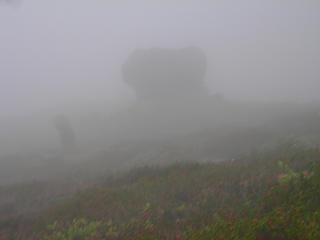 Phantom
PLAY SAFE! SKI ONLY IN CLOCKWISE DIRECTION! LET'S ALL HAVE FUN TOGETHER!
PLAY SAFE! SKI ONLY IN CLOCKWISE DIRECTION! LET'S ALL HAVE FUN TOGETHER!
|
| Back to top |
|
|
dicey
custom title

Joined: 11 May 2004
Posts: 2870 | TRs | Pics
Location: giving cornices a wider berth |
|
dicey
custom title
|
Sun Sep 16, 2007 11:18 pm |
|
|
Thanks for writing the TR Yana!
What a super fun route, everything I'd hoped for, plus some. Don't underestimate the value of bringing a bike up here. Ending a trip with adrenaline vs throbbing feet is something I'm not used to, but could easily grow accustomed to!
After careful consideration and recent trip experimentation, I've decided that it is actually more time efficient to keep all party members present and accounted for, than to go looking for them later  Some of my pics:
 Yana checks out the view 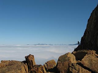 Cloud blanket below 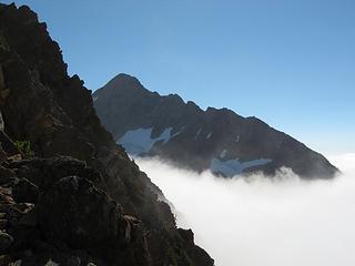 south twin comes into view 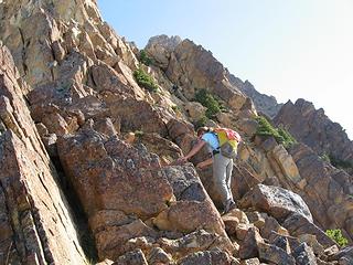 Jeanine scrambling 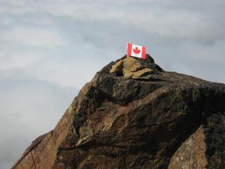 North Twin Sister summit 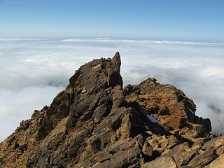 Looking down 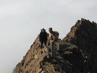 descending into the clouds 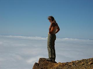 Standing at the edge of clouds
|
| Back to top |
|
|
Justus S.
Member
Joined: 17 Nov 2004
Posts: 1298 | TRs | Pics
Location: WA |
Looks like a sweet trip. Thanks for the report and pics.
|
| Back to top |
|
|
peppersteak'n'ale
Member
Joined: 28 Aug 2003
Posts: 1996 | TRs | Pics
|
Great TR, looks like an absolutely fun time (especially like those "sea of clouds" pics ) Did you ever show those Canadians who's who and knock that thing off the north summit once and for all 
|
| Back to top |
|
|
Spotly
Member

Joined: 06 Jan 2004
Posts: 3723 | TRs | Pics
Location: Spokane Valley |
|
Spotly
Member
|
Mon Sep 17, 2007 5:10 am |
|
|
Nice TR. And nice shoes on Dicey too 
|
| Back to top |
|
|
Guiran
Member
Joined: 03 Mar 2004
Posts: 621 | TRs | Pics
Location: University of Washington |
|
Guiran
Member
|
Mon Sep 17, 2007 7:45 am |
|
|
Wow, that looks fun. 
|
| Back to top |
|
|
|
|
You cannot post new topics in this forum
You cannot reply to topics in this forum
You cannot edit your posts in this forum
You cannot delete your posts in this forum
You cannot vote in polls in this forum
|
Disclosure: As an Amazon Associate NWHikers.net earns from qualifying purchases when you use our link(s). |


 great tr and pics lady!! Good stuff. from now on you or dicey have to write the reports. i suck at writing compare to you two.
 nothing drags that girl! good stuff!!!


