| Previous :: Next Topic |
| Author |
Message |
Justus S.
Member


Joined: 17 Nov 2004
Posts: 1298 | TRs | Pics
Location: WA |
August 16, 2008
Destinations: Bulls Tooth (6840+), Doughgob, and Lemool (6284)
I had been wanting to visit all the lakes and peaks in the Bulls Tooth area for quite some time. I have looked over to it from so many different perspectives. Well, I finally made the trip.
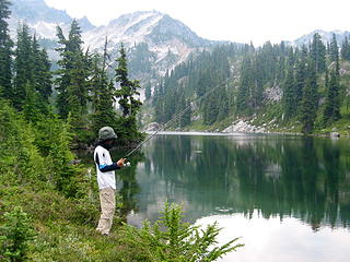
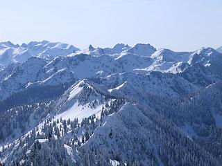 Bulls Tooth area1 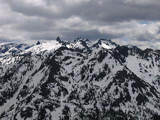 Bull Tooth area2 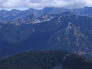 Bulls Tooth area3 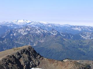 Bulls Tooth area4 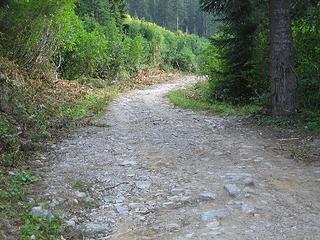 road 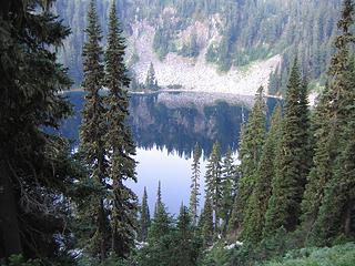 Josephine from above 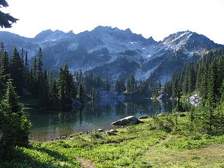 Lower Chain and Bulls Tooth 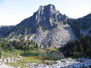 upper Chain 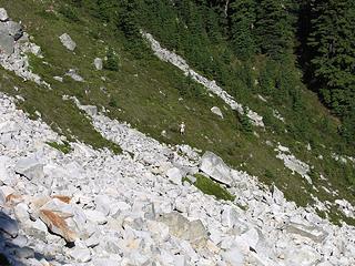 Traversing above the Chains 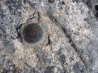 BM 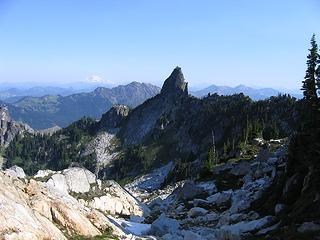 Bulls Tooth Spire from near Bulls Tooth 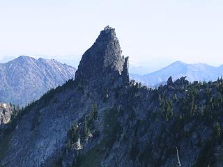 zoom of Bulls Tooth Spire 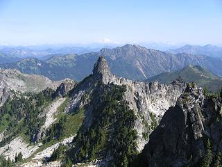 From Bulls Tooth 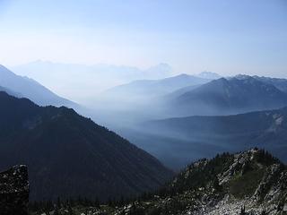 Looking toward the chants, smoke filled valleys 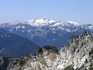 Daniel 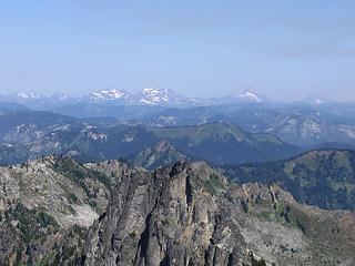 Cristos and Sloan 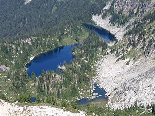 Chains 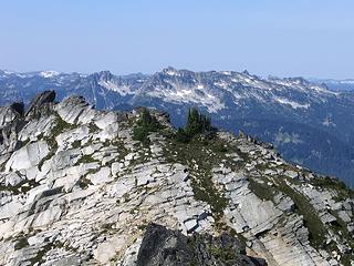 Looking toward Thunder 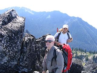 some toothy grins on Bulls Tooth 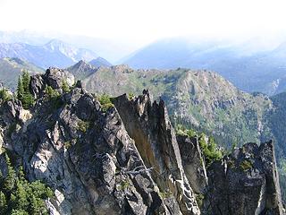 Doughgob from Bulls Tooth 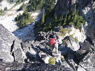 Dropping down from Bulls Tooth 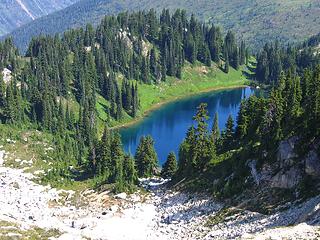 zoom 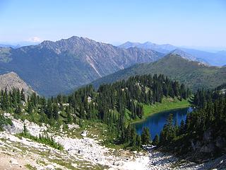 Doelle from saddle 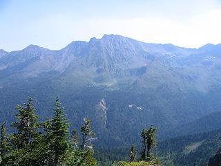 Chiwaukums 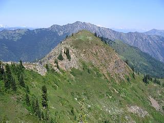 Doughgob summit2 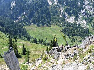 Green Valleys 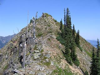 Mike heading up Doughgob 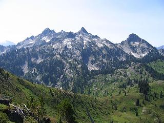 Bulls Tooth from Doughgob 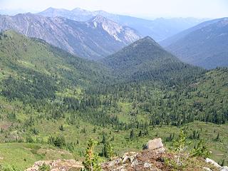 mule creek valley 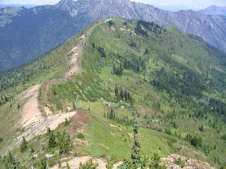 green ridges 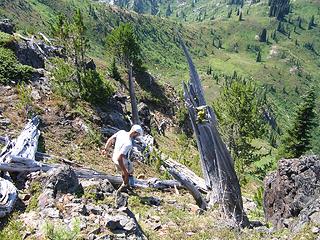 heading down 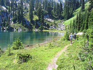 Doelle Lakes 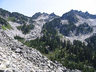 Bulls Tooth from on the descent to the Chains 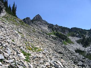 Looking at the spire 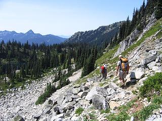 hiking back to the Chains 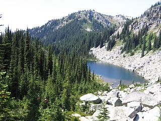 Chains and Lemool 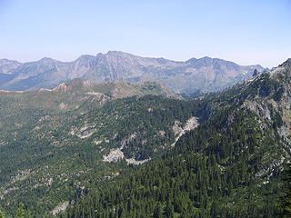 Chiwaukums 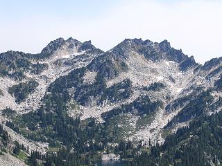 Bulls Tooth(left of center) from Lemool 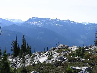 toward Thunder 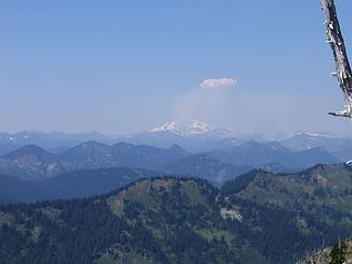 Fire flaring up near Glacier Pk 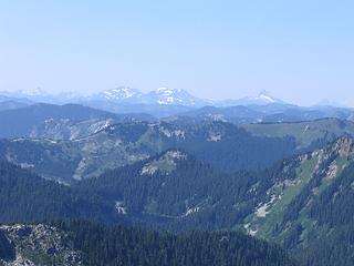 Monte Cristos and Josephine 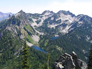 Chains and Bulls Tooth from Lemool  Iron on Lemool 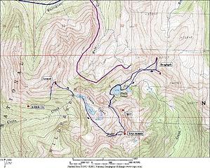 map of area
|
| Back to top |
  
|
|
Opus
Wannabe

Joined: 04 Mar 2006
Posts: 3700 | TRs | Pics
Location: The big rock candy mountain |
|
Opus
Wannabe
|
 Mon Aug 18, 2008 8:11 am |
|
|
That's such a nice little set of lakes. I went up there last summer. Did you guys get to the tooth with the register or the one USGS calls the true summit? I found the register last year and despite it being in place for a few years there were very few entries.
|
| Back to top |
|
|
cartman
Member
Joined: 20 Feb 2007
Posts: 2800 | TRs | Pics
Location: Fremont |
|
cartman
Member
|
Mon Aug 18, 2008 9:44 am |
|
|
Great pics, Justus. That's really nice terrain and scenery--looks like it would be an ideal Sept. trip.
|
| Back to top |
|
|
puzzlr
Mid Fork Rocks

Joined: 13 Feb 2007
Posts: 7220 | TRs | Pics
Location: Stuck in the middle |
|
puzzlr
Mid Fork Rocks
|
Mon Aug 18, 2008 10:18 am |
|
|
Great report Justus. 13 hours is a long time to be hiking on a hot day like that!
|
| Back to top |
|
|
Get Out and Go
Member

Joined: 13 Nov 2004
Posts: 2130 | TRs | Pics
Location: Leavenworth |
| Quote: | | One plus to doing this as a day trip, we didn't have to lug heavy packs up this section. |
 That stretch was a toughie on the overniter for my son and I a couple weeks ago. That stretch was a toughie on the overniter for my son and I a couple weeks ago.
| Quote: | | fish greeted us as they where jumping for their morning meal |
  Middle Chain Lake
"These are the places you will find me hiding'...These are the places I will always go."
(Down in the Valley by The Head and The Heart)
"Sometimes you're happy. Sometimes you cry.
Half of me is ocean. Half of me is sky."
(Thanks, Tom Petty)
"These are the places you will find me hiding'...These are the places I will always go."
(Down in the Valley by The Head and The Heart)
"Sometimes you're happy. Sometimes you cry.
Half of me is ocean. Half of me is sky."
(Thanks, Tom Petty)
|
| Back to top |
|
|
Andy D.
Member

Joined: 19 Apr 2004
Posts: 209 | TRs | Pics
Location: Bow, WA |
|
Andy D.
Member
|
Mon Aug 18, 2008 10:54 am |
|
|
Nice work Looks like a fun trip. I was wondering how bad that Mill Creek Rd was, thanks for the info.
|
| Back to top |
|
|
Mike Collins
Member
Joined: 18 Dec 2001
Posts: 3100 | TRs | Pics
|
| Quote: | | Did you guys get to the tooth with the register or the one USGS calls the true summit? I found the register last year and despite it being in place for a few years there were very few entries. |
The USGS marks the map incorrectly as Sylvester named it. He described the Bull's Tooth as "...a great fang on the jawbone of Icicle Ridge." The triangulation benchmark is located on one of the highpoints on the ridge as 6807. This is not the true "Bull's Tooth." . We touched the benchmark as well as the higher point identified by Jeff Howbert as "Bull's Tooth" at elevation 6840+. The true Bull's Tooth was climbed by Trailcat and written up with wta.org several years ago. We signed the PVC register and count it as reaching the peak identified with the Back Court list. We did not climb the Bull's Tooth named by Sylvester which is referred to as "Bull's Tooth Spire" in Justus' photo.
|
| Back to top |
|
|
Opus
Wannabe
Joined: 04 Mar 2006
Posts: 3700 | TRs | Pics
Location: The big rock candy mountain |
|
Opus
Wannabe
|
Mon Aug 18, 2008 5:18 pm |
|
|
Thanks for the info! There are so many teeth up there it's very confusing. I'm glad I muddled my way up to the one with the register, though I didn't find the marker. When I first arrived at Chain lakes I was sure "Bulls Tooth Spire" was the correct one despite my compass bearings. So much so that I went to the notch between Chain and Doelle to get a better look at it.
|
| Back to top |
|
|
Mike Collins
Member
Joined: 18 Dec 2001
Posts: 3100 | TRs | Pics
|
Read Trailcat's writeup with wta. The true Bull's Tooth involves exposure not found on the Back Court highpoint. Bull's Tooth looks exactly as it sounds. It is the isolated spire off from the main ridge.
|
| Back to top |
|
|
wildernessed
viewbagger

Joined: 31 Oct 2004
Posts: 9275 | TRs | Pics
Location: Wenatchee |
Nice pics, a single summit is not enough ?, I don't think I will ever understand the Bulls Tooth controversy, "Bull Tooth is not the real Bulls Tooth". 
Living in the Anthropocene
Living in the Anthropocene
|
| Back to top |
|
|
Mike Collins
Member
Joined: 18 Dec 2001
Posts: 3100 | TRs | Pics
|
It gets more confusing...Today I went to the Suzallo Library to look at maps. I was looking for any possible mistake with the name "Doughgod Creek." Jeff Howbert must have thought the name was a typo with the intent being "Doughgob Creek." Not so at all. Doughgod Creek was named exactly that by A.H. Sylvester. I researched three different dictionaries of western words. Doughgod is the term used for dough fried in a pan by miners and foresters. It is probably a corruption of the word "doughgood". One map from 1934 actually had the name Dogwood Creek for this same creek. The name Doughgod was on a 1927 map though so it is the first name given for the previously unnamed watercourse.
|
| Back to top |
|
|
Get Out and Go
Member
Joined: 13 Nov 2004
Posts: 2130 | TRs | Pics
Location: Leavenworth |
It's a vortex of confusion, I tell you.  Don't forget the pronunciation debate of "Doelle". Don't forget the pronunciation debate of "Doelle".
"These are the places you will find me hiding'...These are the places I will always go."
(Down in the Valley by The Head and The Heart)
"Sometimes you're happy. Sometimes you cry.
Half of me is ocean. Half of me is sky."
(Thanks, Tom Petty)
"These are the places you will find me hiding'...These are the places I will always go."
(Down in the Valley by The Head and The Heart)
"Sometimes you're happy. Sometimes you cry.
Half of me is ocean. Half of me is sky."
(Thanks, Tom Petty)
|
| Back to top |
|
|
Justus S.
Member
Joined: 17 Nov 2004
Posts: 1298 | TRs | Pics
Location: WA |
This little tidbit of info from Howbert's site.
| wrote: | | The name chosen for Point 6172 in the Back Court list is in fact 'Doughgob', not 'Doughgod'.
As explained by John Roper: Doughgod Creek has appeared as such since the 1901 Chiwaukum quad. However, Hitchman says, apparently incorrectly, 'In 1918 or 1919, it was named by Forest Supervisor A. H. Sylvester, for the camp bread which was cooked in frying pans by prospectors, sheepherders, and foresters'. At any rate, that dough sounded more like a gob than a god to Jeff and me, so a little alteration was made in the spelling.
Plus the map contours for this landform look a lot more gob-like than god-like ....
Lemool is the word in Chinook jargon for mule. ] |
|
| Back to top |
|
|
Mike Collins
Member
Joined: 18 Dec 2001
Posts: 3100 | TRs | Pics
|
Western Words": A Dictionary of the Range, Cow Camp, and Trail by Ramon Adams lists doughgod as "A slang term for biscuit."
The American Thesaurus of Slang by Lester Berrey in 1942 lists doughgod as "biscuits made of fermented bread."
A Dictionary of the Old West 1850-1900 by Peter Watts lists doughgods as "a cowboy name for biscuits or a loggers name of camp bread."
Rather than banter about what sounds right I went to the library, blew the dust off some dictionaries, and looked up the word. I also reviewed the maps extant for that area. The 1901 map which I looked at was actually printed in 1927. The topography was done in 1901. Sylvester was in Washington in 1897 working as a topographer. It is possible that Hitchman had his dates wrong. It is also possible that with the later printing the name was added onto the previously unnamed watercourse. The book which is authored by Hitchman was compiled by people after his death. The redactors who sifted through his notes may have made an error too. The fact remains that doughgod is a word which is albeit antiquated but at one time was in the parlance of people working outdoors. Doughgob is a modern fabrication.
|
| Back to top |
|
|
|
|


